The City of New Berlin,
Wisconsin conducted an Urban Ecological Analysis (UEA) to map and
analyze the benefits of trees and green spaces. The presentation
will show: 1) the methodologies used to conduct the analysis; 2)
the benefits of the City’s trees in terms air pollution
removal, energy conservation and storm water retention; 3) how
current development regulations effect trees; and 4) how the
analysis help to alter the regulations to enhance the development
of the City. The City used Arcview, Image Analysis, Spatial
Analysis and American Forest’s CITYgreen software to perform
the analysis.
The City closely followed the suggested
American Forests Urban Ecosystem Analysis Process: First,
identify policy issues. Second, acquire necessary GIS data
such as aerial photos, property lines, etcdetermine
ecostructures and select sample sites. Fourth, conduct field
inventory. Fifth, digitize trees, buildings, and .
Third, impervious surfaces and input data. Sixth, run
CITYgreen analysis. Seventh, estimate citywide results.
Eight, present results.
Identify Policy Issues
A New Berlin Park and Recreation
Survey Report was prepared in November 2000. This
survey found that 84% though old growth woodlands should be
preserved. In addition, 80% preferred mostly natural
parks. This is a indication that the citizens of New
Berlin want to preserve trees
GIS Data Acquisition
The City is fortunate to have most of
the GIS data layers needed by the analysis. The City already
possessed property, street, surface water, soil, zoning, land
use, slope and building footprint maps in addition to
relatively current aerial photography.
However, satellite photography is needed
to infer the site analysis to the entire city. The City
purchased multispectral satellite photography from Space
Imaging Inc. The photo was acquired on July 16, 2000.
The multispectral image contains four separate bands: red,
green, blue, and near infrared. This allowed the City to find
the areas of vegetation by using the Normalized Difference
Vegetation Index (NDVI) using Arcview’s Image Analysis
Extension. Areas with vegetation will have high NDVI
values. Water-based elements like clouds and lakes have
negative values. Roads, bare soil, and buildings
usually have near zero values.
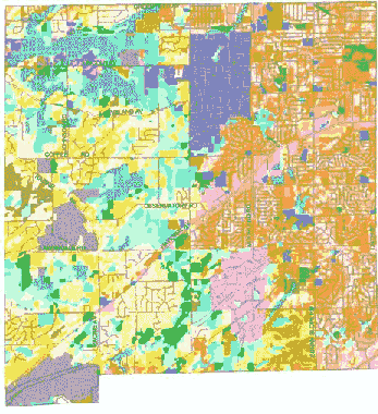
Ecostructures
The next step of the Urban Ecological
Analysis is to select sample sites that are representative of
different land use and land cover characteristics. CITYgreen
referees to these as “ecostructures”.
Ecostructures are formed when land cover
data is combined with other data representing land use,
neighborhoods, or watersheds. These Ecostructures stratify
the City into basic ecological components (i. e. single
family, high-density housing - high-density tree canopy,
etc.). .
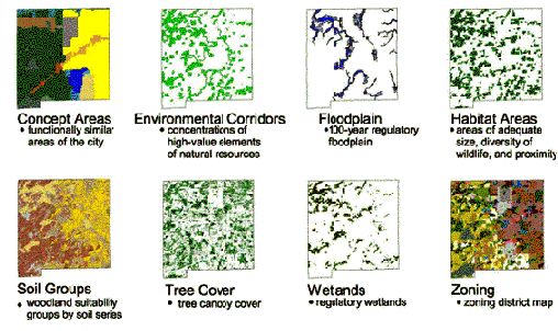
Eight layers were chosen to be used to determine the
ecostructures: Planning Concept Areas, Environmental
Corridors, Floodplain, Habitat Areas, Tree Soil Groups, Tree
Cover, Wetlands, and Zoning. The Growth &
Development Master Plan identified twelve Concept areas that
are functionally similar areas of the city. Environmental
Corridors were previously identified areas that contain
concentrations of high-value elements of natural
resources. Floodplain is the 100-year regulatory
floodplain. Habitat Areas were previously identified as areas
that contain a good diversity of wildlife. Soil Groups
identified the soil series woodland suitability groups. Tree
Cover identifies areas with tree canopy cover. Wetlands are
mapped regulatory wetlands. Zoning is the official zoning map
of the City.
The Eight
Layers
|
|
These eight layers were merged together by doing a
“union” operation. This resulted in more than three
thousand unique combinations of the layers. Obviously this is
much more detail than necessary and a methodology was used to
determine similar combinations. The coverage was converted to
a 100x100’ grid. This process alone reduces the
number of unique combinations by half due to the smallness of
some of the combinations. A statistical correlation was then
done to determine which layers had similar characteristics.
For example: poorly drained soils was correlated with the
wetland layer and could be considered one layer instead of
two. This was done until there were only thirty groups left.
Similarity was determined by using the statistical
correlation and local insight as guides. The process
continued until there were only thirty combinations that were
reasonably different.At the end of the process it was decided
to merge two of the quarry-related groups together.
Each of the combinations is an ecostructure with different
land use and land cover characteristics. Staff then created
an ecostructure classification map.
City-Wide
Ecostructures
Classification Map
|
|
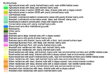
Ecostructure
Detail
|
|
Ecostructures
Classifications
|
|
Inventory
From the twenty-nine ecostructures identified, twenty-nine
sites were randomly selected. On closer examination of
the sites and given time and budget constraints, only the
sites in the developed areas of the City would be inventoried
on-site. Several sites, such as the quarry and agricultural
sites had few trees and they were inaccessible. It was also
felt that there was more interest in determining the impact
of trees in residential, commercial, and industrial areas,
rather than in farm lands, parks and quarries.
The City worked
with a local consultant, Geographic Marketing Advantage from
Franklin, Wisconsin to inventory a total of 15 study areas.
Each of the 15 study areas was chosen from a series of
identified “Ecostructures”. The consultant
ground-truthed each site using aerial photography as a base.
At each site, the consultant located all of the trees and
identified them on the one-foot resolution aerial photos.
This method was found to be more locationally accurate than
locating with GPS. At best, GPS provided an accuracy of
around ten feet, while the aerial photos proved to be
accurate within five feet. The consultant, using datasheets,
collected information on each tree including species, DBH,
diameter class, height class, health, ownership, potential
conflicts, and groundcover. The consultant then entered this
information into a database.
Staff then began performing the study area analysis using
CITYgreen. Staff digitized the locations and sizes of each
tree in the study area using the datasheets. Buildings and
impervious surfaces were drawn onto the study area using
aerial photos and existing GIS data layers.
Site Analysis
When all the map features were digitized and the field
data entered into CITYgreen, staff prepared the site
statistics. This includes site, tree, building, and
impervious surface statistics. The Findings section lists the
relevant statistics for each site.
Once this was done CITYgreen then analyzed the
environmental benefits of the trees on each site. Staff then
preformed analysis or carbon storage and sequestration, air
pollution removal, energy conservation, changes to stormwater
runoff calculations, and modeled future benefits.
Carbon Storage and Sequestration
CITYgreen estimated the carbon storage capacity and
the annual carbon sequestration rates of trees within a
study area, using formulas adapted from US Forest Service
research. CITYgreen references feature data about tree
canopy cover to make its estimates. CITYgreen also looks
at trunk diameter information recorded in the tree
attribute table, calculating the average diameter
distribution for the site.
Air Pollution Removal
CITYgreen estimates the annual pollutant removal
capacity of trees within a study area, using removal
rates established by the US Forest Service research in
Milwaukee, Wis. Dollar benefits estimates produced by
CITYgreen are based on actual and external costs
associated with a pollutant once it enters the
atmosphere, as documented by the US Forest Service.
CITYgreen references feature data about the tree canopy
cover to make its estimates.
Energy Conservation
CITYgreen estimates the direct shading benefits trees
provide to residential buildings within a study area,
calculating the kilowatt-hour savings and solar savings
for the study site and per household. Each house is
estimated to have $200 in annual cooling costs. CITYgreen
references attribute data about a tree's species and size
and combines it with information about canopy shape, leaf
persistence and shading attributes. CITYgreen uses
features data to determine the proximity of trees to
buildings and to find out if a tree is on the right side
of a house to provide shade. The energy savings analysis
is applied only to trees that are within 35 feet of
buildings. Energy conservation is not computed for
commercial buildings.
Storm Water Runoff Reduction
CITYgreen estimates the change in stormwater runoff
calculations within a study area, using curve numbers for
urban and suburban soils recommend by the USDA Natural
Resource Conservation Service. The software employs
methods documented in Technical Release 55: Urban
Hydrology for Small Watersheds, commonly known as
"TR-55," to estimated the flow of water over
land within the study area boundary. CITYgreen
illustrates the impact of tree canopy and vegetation on
storm water runoff, time of concentration (in hours), and
peak flow for a study area. CITYgreen estimates the
change in amount of water that would have to be managed
if all trees within a study area were removed. These
values are only for illustration purposes, and are not
intended to be a substitute for reliable engineering site
analysis.
The storm water runoff analysis needed additional
information about the site. The soil hydrologic group
(very pervious, somewhat pervious, somewhat impervious,
very impervious) was identified using the existing GIS
soil map and database. The average percent slope of the
site was measured using existing GIS elevation data
layers. A three inch storm event was used for analysis.
For comparison, the official City 2-year 24-hour storm
event is 2. 7 inches. A Type II Natural Resources
Conservation Service Rainfall distribution was used for
every analysis. CITYgreen stormwater analysis may not be
used for determination of compliance with the Stormwater
Management Plan.
Modeling Future Benefits
CITYgreen can estimated the future benefits of trees.
The software estimates the future growth of trees within
a study area. Looking the tree's size, height, diameter,
and species growth rate a new modeled tree layer is added
that will show what the tree canopy will be in the
future. This new "future" tree layer can then
be used to run the same analysis processes described
above. This can then be used to compare future benefits
of the existing urban forest with existing benefits.
In addition, when detailed landscaping plans are
submitted for a proposed development. The relevant
information about the trees can be entered and the
benefits can be estimated for the time at planting and
the future.
City-Wide Analysis
Two different methods were used to infer to the results to
the rest of the City. The first is to infer the site results
to the ecostructure through averaging. The second is to use
the Normalized Difference Vegetation Index (NDVI) to compute
the estimate. The results for both methods are presented,
however the NDVI is more complete and assumed to be more
accurate in most cases.
Estimation by Averaging
Many CITYgreen studies infer the sample sites to the
rest of the area by finding the average of the
"value" per acre to compute a "rate",
such as average number of trees per acre, average carbon
storage per acre, average storm water benefits per acre,
etc. This "rate" (average value per acre) is
then multiplied by the total acres in the ecostructure.
The common exception to this is the energy analysis.
Instead of finding the average savings per acre, the
savings per household are usually computed. This
"rate" makes much more sense to the reader.
However, when the estimates were computed on both per
acre and a per lot basis, the estimates differed by as
much as 80%. This method also places very heavy emphasis
on identifying costructures. Changing how ecostructures
are identified results in significant changes in the
results. In addition, there is no way to infer results to
ecostructures that were not sampled.
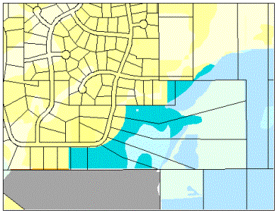
Brightness shows
higher NDVI values
and thus denser
vegetation.
(Bare soil shows dark) |
 |
NDVI Regression Estimation
The City attempted to find a better method to infer
the results. One method was to use the satellite photos
as a base for the CITYgreen regional analysis module.
However, the IKONOS photos (4 meter pixel), it was
discovered are not compatible with CITYgreen software.
SPOT photos (30 meter pixel), which are compatible with
CITYgreen, were not obtained since IKONOS has a factor of
56 times the resolution of SPOT photos. This low
resolution is not suitable for a total study of 37 square
miles.
The Esri's Arcview Image Analysis extension can
compute the Normalized Difference Vegetation Index
(NDVI). NDVI is a common method to compute the relative
health and density of vegetation. The NDVI would be used
to infer the results from the individual sites to the
City as a whole.
The average NDVI value was found for each site. The
various characteristics of each site (% canopy, # of
trees, carbon storage per acre, runoff, etc.) was
determined. A simple-linear regression (least-squares
method) was then used to fit a line through each of the
site values. The characteristic was considered the
dependent variable and the NDVI value is the independent
variable. The line is determined by: characteristic =
m * NDVI + b where (m = slope & b
= intercept as determined by regression). It was
found that the regression equation was able to account
for almost 50% to 90% (R Squared) for the differences
between the sites.
This method has the advantage over the averaging
method in that the tree value can be computed for
anywhere in the city based on actual site observation
(the satellite). The detail is only limited by the
resolution of the satellite photograph and the ability to
compute a NDVI. Each site does not have to be consistent
throughout an ecostructure. Ecostructures are not
necessary for estimation, but can be used to compare
different areas, such as residential verses commercial.
It would be possible, and enlightening, to compare values
based on different factors such as current land use,
zoning district, or even city council district.
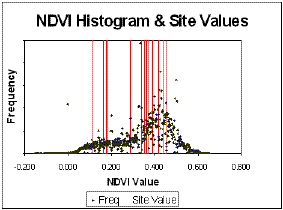
The frequency of
NDVI is plotted
against the NDVI
values for the
sample sites.
Since with the
highest NDVI
values were not
sampled, these
areas of the City
are most likely
underestimated.
|
 |
It must be noted that since NDVI values vary from week
to week based on the season, no "one" formula
can be used. The "correct" m and b
values must be determined for every image since they will
vary from image to image. For statistics involving a
percent, such as canopy cover, the regression was
performed on the observed percent. For other statistics,
such as number of trees, the rate per acre was computed
and the regression was performed on this rate, such as
number of trees per acre.
There are some limitations to this method. Sample
sites with a full range of NDVI values should be
inventoried. This will help to minimize statistical
error. Areas with healthy and dense vegetation, such as
agricultural land and golf courses, are overestimated.
These areas will have high NDVI values that do not
necessarily correlate with urban forest canopy. One
possibility is that these areas would be estimated
independently of the remaining area with strategic
sampling.
Forest & Site Composition
Site Analysis
Site statistics, such as total area, canopy area,
impervious area, building area, and number of homes were
gathered by aerial photography, GIS data layers, and
ground truthing at each site. Tree statistics, such as
species identification, size, location, and health were
gathered by aerial photography and ground truthing at
each site. The results of each site can be found in.
Analysis summaries of each site are shown in Figure 1.
It is not surprising to find that the residential
sites had the highest percentage tree canopy and least
building and impervious surface cover. However, the
Business Park and Commercial sites had many more trees
per site, which is not surprising since these sites are
much larger. All sites were equally diverse with an
average of 5.6 species of trees. It is interesting that
urban residential sites a higher average DBH than rural
residential sites, but rural residential sites had a
higher average height class. Business Park and Commercial
site trees' were much smaller than residential site
trees. It should also be noted that none of the Business
Park and commercial sites violated maximum 75% buildings
and impervious surfaces coverage requirement while the
average DBH is the required minimum.
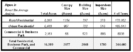
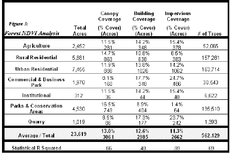
City-Wide Analysis
City-wide analysis of the urban forest characteristics
were computed by both the Site Average analysis, Figure
2, and the NDVI analysis, Figure 3. This
discussion primarily covers the NDVI analysis. The Site
Average analysis values are presented for comparison.
Over 23,000 acres was part of the analysis. The urban
residential ecostructure is the largest ecostructure in
the City.
Canopy Size: The City has an average canopy
cover of 13%. The tree canopy covers more than 3000
acres. Parks and conservation areas had the highest
average canopy cover, 16.5%. While urban residential
areas had the most canopy coverage, 886 acres
Building Size: Not surprisingly,
Commercial & Business Park areas had the highest rate
building cover, 17.7%. However it was surpassing to see
that the quarry and agricultural areas also had high
estimates of building coverage as computed by the NDVI
analysis. This is due to NDVI values for exposed soil and
buildings are almost identical. It should be noted that
this estimation has the lowest statistical certainty of
any rate computed by the NDVI analysis.
Impervious Area: Again Commercial &
Business Park areas had the highest rate impervious
cover, 24.7%. However urban residential areas had the
most in terms of acreage, over 1000 acres of impervious
cover.
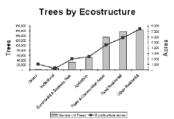
Number of Trees: It is estimated that there are
over 560,000 trees in the City. Over half of these trees
are in residential areas. Almost a quarter of the City's
trees are in parks and conservation areas. Quarries, not
surprisingly have the fewest trees.
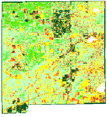
Many of the
City's Parks
have a dense
canopy |
 |
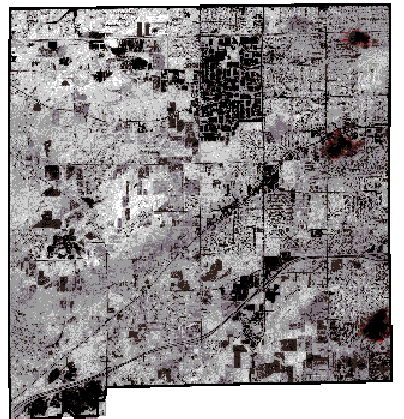
Black - No Tree Cover
Red - Little Tree Cover
Yellow - Medium Tree Cover
Green - Heavy Tree Cover
|
|
This graph shows
that the number of
trees in a ecostructure
area closely parallels
the size of the ecostructure.
It also quickly shows
which areas have
more or less than the
average.
|
 |
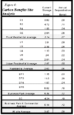
Carbon Benefits
Site Analysis
CITYgreen estimated the carbon storage capacity and
the annual carbon sequestration rates of trees for each
site. The results of each site are shown in Figure 4.
At first glance it may be surprising that the Business
Park and Commercial sites had the highest amounts of
carbon storage and rates of sequestration per site.
However, some of the sites are large and have many
younger trees that store carbon and high rates.
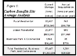
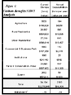
City-Wide Analysis
City-wide estimates carbon storage and sequestration
were computed by both the Site Average analysis, Figure
5, and the NDVI analysis, Figure 6. This
discussion primarily covers the NDVI analysis. The Site
Average analysis values are presented for comparison. The
carbon storage benefit is estimated at $22 per ton for
both carbon storage and sequestration.
Carbon Storage: The trees in City store over
94,000 tons of carbon valued at over $2 million. Over
half the carbon storage is in the residential areas,
another quarter of the storage is in the park and
conservancy areas. Urban and rural residential areas
store nearly equal amounts of carbon.
Annual Carbon Sequestration: The trees in City
sequester over 2100 tons of carbon valued at over
$46,000. Over half the carbon sequestration takes place
in the residential areas, another quarter of the
sequestration is in the park and conservancy areas. Urban
and rural residential areas sequester nearly equal
amounts of carbon.
Whenever possible,
existing trees are
preserved
|
 |
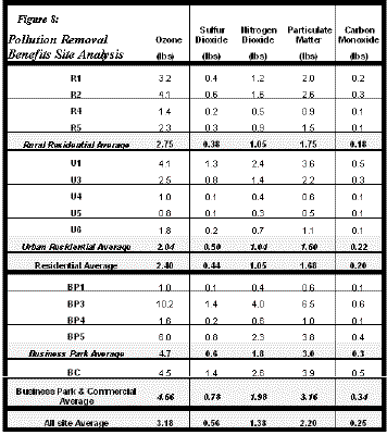
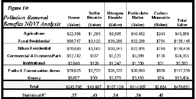
Pollution Removal Benefits
Site Analysis
CITYgreen estimated the annual removal rates for
ozone, sulfur dioxide, nitrogen dioxide, particulate
matter, and carbon monoxide. The results of each site are
shown in Figure 8.
Much like the carbon sequestration analysis, the
commercial and business parks sites had the higher
amounts of removal of pollutants per site. This is mostly
likely due to these sites having younger, smaller trees
that remove pollutants at higher rates.
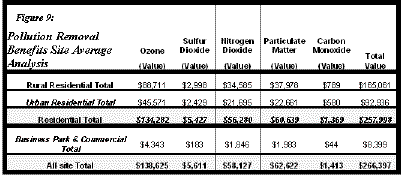
City-Wide Analysis
City-wide estimates value of pollution removal by both
the Site Average analysis, Figure 9, and the NDVI
analysis, Figure 10. This discussion primarily
covers the NDVI analysis. The Site Average analysis
values are presented for comparison. The dollar benefits
estimates produced by CITYgreen are based on actual and
external costs associated with a pollutant once it enters
the atmosphere as documented by US Forest Service
research in Milwaukee.
Pollution Removal: City trees remove over
$478,000 worth of pollutants each year. Urban residential
areas removed the most pollutants, followed by rural
residential areas, and parks and conservation areas.
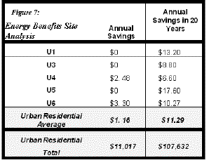
Energy Benefits
Estimates for the energy benefits of trees were
computed by Site Average analysis, Figure 7. NDVI
analysis was not performed since the energy savings is
mostly computed by the position of trees relative to the
building. The NDVI values would have little correlation
with this. Urban residential sites were studied since
they typically were smaller lots with more trees. Rural
residential sites, while often having more trees,
typically had trees farther from the homes and thus
didn't provide energy benefits. In addition, the
CITYgreen analysis only computes residential savings, not
commercial savings and thus no analysis for those
ecostructures were computed.
Annual Savings: Trees provided energy benefits
on only two of the sites sampled. This is most likely do
to the city being a relatively new community with new
homes and young trees. However, this is not to say that
the savings is not significant, over $11,000 is saved in
cooling costs each year by trees.
Annual Savings in 20 Years: The savings
provided by trees is expected to increase by a factor of
ten in twenty years. One of the benefits of CITYgreen is
that it can "grow" trees based on current size,
species and health condition. When the trees on the urban
residential sites were aged 20 years, it was found that
the average annual savings increased from $1.16 to $11.29
per home. This translates into savings of over $107,000
each year just in the urban residential areas. This
clearly shows it pays to maintain healthy and long-living
trees.
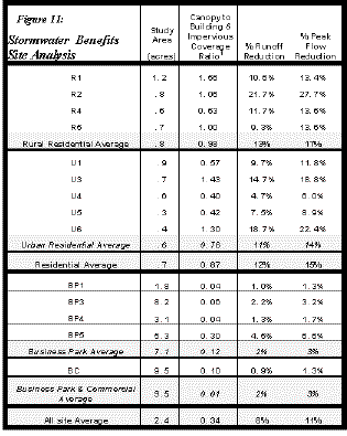
Storm water Benefits
Site Analysis
CITYgreen estimated the benefit of trees due to the
change in initial abstractions for calculating storm
runoff. This is done by comparing the site with trees and
then without trees to provide the difference.
The sites with the higher ratios of canopy to building
and impervious cover had the greatest change of runoff,
peak flow, and volume. On average, the rural residential
sites had more storm water benefits than urban
residential sites. The commercial and business park sites
had nearly identical rates of reduction.
City-Wide Analysis
City-wide estimates of the storm water benefits of
trees was not performed. The City felt that the methods
used by CITYgreen made too broad of assumptions that
reduced the value of the results. These assumptions may
lead to missinterpreted of the results.
City of New Berlin Policy
Current Zoning Ordinance
The present revision of the City of New Berlin Zoning
Ordinance was adopted in January 1993. It contains
specific guidelines on the preservation and maintenance
of the urban forest. These polices should be kept in mind
when looking at the results of the analysis. The
following is a summary of these Zoning Ordinance
requirements:
Limits to tree cutting in lower-density and
multifamily residential districts and (Rural Estate R-1,
Suburban R-2, Low-Density R-3 & R-4, Two Family Rd-1
and Multi-Family Rm-1):
- Lots shall not be clear-cut, no more than 10,000
square feet (20,000 in R-1 and R-2 districts) of
natural vegetation shall be removed during
construction.
Lot coverage and Open Space requirements for
Commercial and Business Park zoning districts:
- Landscaped areas shall occupy a minimum of 25% of
the lot area
- Buildings and impervious surfaces can cover a
maximum of 75% of the lot area
Woodland Preservation requirements:
- It is City policy to preserve significant natural
forest and woodland areas in the City.
- redit is given for existing trees in satisfying
landscaping and screen requirements
- Deciduous trees five inches or larger in caliper
and coniferous trees ten feet or taller must be
preserved unless it will unduly restrict
development of the site
- Trees that were destroyed without approval must
be replaced
- Development must occur outside the woodland when
practical
- If the entire site is woodland, the development
will be placed to optimize the number of existing
trees that will be preserved
- Utilities are placed to minimize disturbance
- Easements are required to restrict further
disturbance of woodland
- A variety of compatible tree species shall be
used for landscaping or reforestation
Landscaping requirements:
- Landscaping is required in all districts except
residential and agricultural
- One tree is required every 30 feet of public
street frontage
- The minimum size of newly planted trees is:
Deciduous 2 � DBH caliper, coniferous 6 feet
tall, and ornamental trees 1 � DBH caliper.
Parking Lot Screening and Landscape Island
requirements:
- All parking lots (other than those agriculture
and residential districts) must be screened from
residential uses they border
- Landscape islands must total at least 5% of the
surfaced parking area.
- Landscape islands shall consist of trees, shrubs,
flowers and other similar plantings.
- The preservation of existing trees can be
included in the minimum landscaped area
requirement.
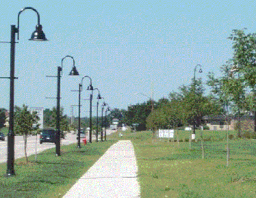
Parking lot
landscaping
|
 |
Growth and Development Master Plan Update
Recommendations
This is a brief overview of the proposed new City of
New Berlin Zoning Ordinance. This ordinance revision is
being conducted as part of the GDMP update process. The
document reviewed was considered the final draft of the
ordinance and only minor changes will likely be made.
Some of the changes made in the language of the ordinance
are a result of the UEA and increase awareness of the
urban forest. Very significant changes have been made to
the landscaping ordinance. The City expects the ordinance
to be adopted by the spring of 2001. Again, these revised
polices should be kept in mind when looking at the
results of the analysis. The following is a summary of
the new Zoning Ordinance requirements:
Woodland and Tree Protection
- The purpose is to preserve the aesthetic
qualities preserve the natural environment;
enhance the developed environment; control
erosion, slippage and runoff; protect wildlife
habitat; and conserve energy.
- A "Limits of Development" (LOD) is
approved by the City as part of the approval
process. No trees may be removed outside the
approved LOD. The maximum LOD for residential
uses is 60% for nonresidential it is 75%
including driveways.
- Deciduous trees greater than 5 DBH or conifers
taller than 10 feet that are inside the LOD shall
be preserved or replaced within similar sized
trees (the ordinance is specific of size and
numbers of trees that are suitable replacements)
- For a strip of trees within 50 feet and
paralleling all navigable water bodies: no more
than 30% of the length of the strip can be
clear-cut; a clear-cut opening cannot be greater
than 30 feet; and the remaining trees shall leave
sufficient cover for buildings.
- Trees cannot be removed for the sole purpose of
providing open views to or from structures except
for safety reasons
The ordinance goes into detail about protecting trees
during construction inside the LOD regarding runoff, root
zones, and utility trenches
- Existing trees greater than 4 DBH of acceptable
quality can be used for landscaping or buffering
requirements
Landscaping and Buffering
The landscaping section has been significantly
expanded, only the basic overview is presented.
- Landscaping is required in all nonresidential
development and multifamily dwellings
- A landscaping plan is required
- Installation
- One tree for every 1000 square feet of lot area
covered by impervious surfaces except parking
lots (this is in addition to parking lot
landscaping requirements) is required
- 60% of the required landscaping shall be in the
front yard.
- A landscaping installation compliance security is
required to insure compliance with the ordinance
- Only native or adapted trees can be used, a list
of over sixty acceptable tree species is included
with the ordinance
- To insure species mix, the ordinance lists the
maximum percentage of any one species based on
the total number of trees on the site
- The minimum sizes of newly planted trees
are: Deciduous 50% 4" DBH, 50% 2" DBH;
Evergreen 50% 8 feet tall, 50% 6 feet tall; and
ornamental trees 2" DBH
- The installed trees must meet the American
Association of Nurseymen specifications for
Number 1 Grade trees (B-grade or park-grade trees
are not permitted)
Street trees.
|
 |
Trees are to be located to not extend beyond the lot
line once it has reached it mature size
- Credit is given for preserving existing trees
within the LOD
- The ordinance goes into detail about proper
method of installation
- Maintenance
- A landscaping maintenance compliance security is
required to insure adequate maintenance for three
years
- The ordinance goes into detail about property
methods of maintenance and lists required
maintenance practices
Parking Lot Landscaping
- All parking lots with five or more spaces must
have perimeter landscaping
- One tree is required for every 20 lineal feet of
parking surface adjacent to an arterial street
(30 feet for non-arterial streets or when the
parking lot is adjacent to the side or rear lot,
40 feet when walls or fences are used),
- Trees should be grouped instead of evenly spaced.
- The tree planting area between the parking lot
and street is a minimum of ten feet (eight feet
for between the parking lot and access drives)
- Should be semi-opaque during winter
- All parking lots with 20 or more spaces must have
interior parking landscaping in additional to
perimeter landscaping
- For every 2500 square feet of parking lot area
one tree will be planted
- Landscape island must account for 10% of the
parking area
- The landscape island must allow for adequate root
aeration
- Plantings are to be arranged to maximize shading
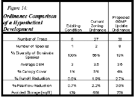
Ordinance Comparisons
A site in the business park that recently need to
improve its landscaping was randomly selected to compare
the requirements of the current and proposed Zoning
ordinance. This site is 3.57 acres, the building and
parking lot cover just under 75% of the site. These
comparisons are shown as Site EXP in.
Existing Conditions: There are only six threes
of the same species on the site that does not meet
current landscaping requirements.
Current Zoning Ordinance: To gain approval of
any proposal, the landscaping must be updated to meet
current requirements. These requirements require one tree
for every 1000 feet of frontage with a minimum size of
2.5 DBH for deciduous and 6 feet tall for coniferous. In
this example, 26 trees in total would be required.
Proposed GDMP Updated Ordinance: The proposed
GDMP ordinance would require 1 tree for every 1000 feet
of frontage (its not on an arterial) and an additional 1
tree for every 3600 square feet of open space. Half of
the deciduous trees must be at least 4 dbh, the other
half must be at least 2 dbh or greater. Half of the
coniferous must be at least 8 feet the other half must be
at least 6 feet. No more than 40% of the trees can be the
same species. In this example, 36 trees would be
required.
Note: CITYgreen
stormwater analysis
cannot be used
for compliance
with the Stormwater
Management Plan.
|
 |
After completed the UEA, staff have a several
recommendations. The recommendations fall under three
categories: How the report can be used as a urban forest
baseline, what changes can be made to the development
process, and improvements in CITYgreen software.
Zoning and Subdivision Ordinances, Development
Policies and Site Planning Guidelines Revision
The proposed GDMP modifications to the landscaping
requirements will increase tree canopy coverage. This
modification should be formally adopted. This will
significantly increase tree canopy in commercial and business
park areas.
The use of CITYgreen analysis methods should be
incorporation into development review of proposals were
landscaping is a primary concern, especially when
preservation of existing trees is an issue.
Although the City does not require landscaping for
residences, the City should promote planting of trees in a
manor that will provide greater energy savings.
Model Baseline
This report serves as a baseline for future residential,
commercial, and business-park development in the City. For
conditions citywide, the use of satellite photos should be
used in the future to track changes against year 2000
conditions. Also, additional sites in the institutional,
agriculture, and conservation lands should be surveyed. This
will allow for more accurate estimations of citywide
conditions.
As more sites are sampled and better estimated are made
using NDVI regression and and land uses the ecostructure map
should be updated.
CITYgreen (v3.0) Software
The software should be modified to be able to use IKONOS
imagery directly for analysis.
A method to estimate the energy benifits of trees on
commercial structures should be developed.
To be able to compare CITYgreen analysis perform in one
study to another study, exact methods to identify
ecostructures should be developed. Exact methods to infer
sample sites to estimate city wide conditions also need to be
developed.
Not available in HTML version.