The College of Natural Resources at Utah State University and the USDA/APHIS have developed the Millville Research Facility into a premier research station. We will provide the Facility with a GIS database system to assist in updating and maintaining of the facility's Master Plan by developing GIS spatial data using ArcView and ArcInfo, compiling FGDC metadata, conducting QA/QC, researching existing utilities mapping with RDBMS, and implementing ArcIMS and the SQL-RDBMS. The RDBMS may expand to include additional research. Esri's ArcSDE will connect the IMS and RDBMS. An ArcView class and an ArcIMS workshop will be taught to train facility managers.
United States Department of Agriculture
Animal and Plant Health Inspection Service
And
Remote Sensing & GIS Laboratories
College of Natural Resources
Utah State University
Research Conducted By:
Pamela J. Pratt
Executive Summary
The College of Natural Resources at Utah State University and the United States Department of Agriculture APHIS have developed the Millville Research Facility into a premier research station. The objective of this work is to provide the Facility with a GIS database management system to assist in updating and maintaining the facility's Master Plan by developing GIS spatial data using ArcView and ArcInfo, compiling FGDC compliant metadata, conducting QA/QC, researching existing utilities mapping with Relational Database Management System, and implementing Internet Map Server and a SQL-RDBMS. The RDBMS may expand to include additional research. Esri's Spatial Database Engine may connect the IMS and RDBMS. Facility managers will attend an Esri certified ArcView course and an application specific ArcIMS workshop developed under this scope. The final product will allow the planning and construction of new structures on the facility based on existing facilities, infrastructure, and environmental concerns. The GIS database system will also enable the facility to better manage the existing infrastructure and protect the research from loss or damage.
The College of Natural Resources would like to better manage their wildlife research facility. Presently, data is not managed well. CNR would like all MRF data to be housed in one place. This led to the research question of "Which multi-user database will be capable of handling the needs of CNR and the wildlife facility? And, will the RDBMS work well with ArcIMS and SDE? If so, how will they function together with the amount of data that will be managed and displayed?" This will be basic, state-of-the-art research.
The methods of data collection are through the use of Global Positioning Systems, requests for hardcopy and softcopy spatial and tabular data, interviews with facility personnel, and technical papers and articles.
The findings have not been concluded at this time due to the possibility that MRF may use Oracle or Microsoft's SQL Server. The decision on whether to use Oracle or SQL Server will be made in late Fall 2001. This research is not complete as of this time. It will be complete by May 2002. The plan is to conduct the literature review, review the previous Master Plan, continue interviews with facility personnel, build the prototype, test, and implement the GIS database system.
Acronyms
APHIS - Animal and Plant Health Inspection Service
CNR - College of Natural Resources
Esri - Environmental Systems Research Institute, Inc.
FGDC - Federal Geographic Data Committee
GIS - Geographic Information Systems
GPS - Global Positioning System
IMS - Internet Map Server
MRF - Millville Research Facility
QA/QC - Quality Assurance / Quality Control
RDBMS - Relational Database Management System
SDE - Spatial Database Engine
SQL - Structured Query Language
USDA - United States Department of Agriculture
USU - Utah State University
Introduction
The basis of this research is to determine if a GIS database management system will assist the Millville Research Facility in better managing their data and facility. The study will look at Esri's ArcIMS, ArcSDE, and two relational database management systems as the design of the GIS database system. The RDBMSs that will be reviewed are Oracle and Microsoft's SQL Server. Both are multi-user databases with large data storage capacity. Which will serve the facility the best? This question will be addressed by looking at different variables associated with the software.
This research was initiated through a contract with the College of Natural Resources, the Vice President of Research at USU, and the USDA. The study was initiated because the Millville Research Facility requested the collection of several GIS data layers to assist in the updating of the facility Master Plan. Upon review of the tabular data for the facility, it was determined that a larger, secure database management system would be required. A proposal was written to CNR and the USDA to research and implement a large-scale GIS database system for the site.
Problem Statement
CNR would like to better manage their wildlife research facility and its data. They have data in multiple databases, some data is not managed, and some data is not collected at all. CNR would like to collect all the spatial and tabular data and research into one manageable database with a spatial component. This would allow the reduction of redundant data and save money for both the College and the USDA by creating an efficient, well designed database system that will answer questions that facility personnel have about the site.
Research Question
Which multi-user relational database management system will provide the most efficient data handling and storage capabilities for the Millville Research Facility, Oracle or SQL Server? Will both of the RDBMSs function well with Esri's ArcIMS and SDE? If so, how will they function together with the amount of data that will be managed and displayed?
This will be basic, state-of-the-art research conducted in an exploratory manner to determine the correlations between the software involved. This research will be conducted in a natural, non-contrived environment.
Data Collection Methods
GIS data has been collected for the facility over the past year. The data was collected using Trimble's ProXRS GPS unit and OmniStar's real-time differential correction subscription. The data was post processed using Pathfinder Office and Esri's ArcView. The data layers were QA/QC-ed and FGDC compliant metadata was compiled on each data layer. The data layers were then posted on the facility's IMS where facility personnel can access it. Facility personnel provided a text list with electrical lines, telephone lines and poles, gas lines, water lines information and attributes. This list included every piece of information about the facility that could be put together by facility personnel (see Appendix A). This information has not been included in the GIS data on the IMS at this time. The information will be house in the RDBMS and accessed through ArcIMS and SDE.
Data Analysis Results
After collecting and reviewing the GIS data, it was determined that the amount of attribute data involved dictated a more robust method of data management than the typical ArcInfo data structure. Also, more GIS data would need to be collected along with all the attribute data. Research into the functionality of ArcIMS, SDE, and a relational database was required. Work began on designing an entity relationship model to help determine the relationships between the infrastructural components. This would help determine the size of the RDBMS required. Additional information will be provided under this section as research is gathered on Oracle and SQL Server.
Research Plan
The plan for conducting this research is to review the technical literature to determine the methods that others have used to put a system like this together. The software manufacturer web pages will also be reviewed for technical content and descriptions of the software capabilities and shortfalls. The 1998, 1999, and 2000 Esri User Conference proceedings have been searched for technical workshops to assist in understanding SDE and how it functions with IMS and a RDBMS. Published white papers will also add useful information to this research. Technical journals have been reviewed for projects completed or underway which are similar to the MRF project. These journals include, but are not limited to, GeoWorld, ArcNews, GeoSpatial Solutions, GeoInfo Systems, ArcUser, and Government Technology. Review of the previous facility Master Plan will assist in determining other categories of data that may need to be collected. Towards the middle of this project, software testing will be conducted to determine the capabilities of the RDBMSs. A prototype will then be developed and tested. The wildlife research facility personnel will be involved in the final decision and will also provide additional information that may be included in the database.
Preliminary Information Gathering and Investigation
Unstructured Interviews
Conversations with Mr. Chuck Gay, Assistant Dean of CNR, have resulted in refining the direction of the project. Continued communications will occur throughout the length of the project to ensure that the user needs are addressed.
Meetings and discussions with Mr. Fred Knowlton, Research Professor, CNR, initiated the list of text information on which the database design is being built (see Appendix A). Continued meetings with Mr. Knowlton will assist in further developing the user needs assessment so that an efficient, useful GIS database management system will be developed for the site.
Interviews with Mr. Russ Mason will be conducted to determine other data needs and research that may be added to the database system.
On-site interviews will occur with organizations along the Wasatch Front who have implemented IMS, SDE, and an RDBMS. The objective during these interviews is to learn how others have made the implementation work for their project, the problems, and what not to do.
The Literature Review
The literature review helps define the variables and provides the framework to proceed further (Sekaran, 2000). Initially, the published and unpublished materials are identified and reviewed. The relevant materials are parsed out, gathered and reviewed once more. The literature review is then written. In this literature review, previous Esri conference proceedings will be used along with technical journals. In addition, the industry web pages will be reviewed for content and usability.
Koeppel (2001) states that ArcIMS revolutionizes the way users access and interact with Internet mapping. It is the only software that enables users to integrate local data sources with Internet data sources for display, query, and analysis using a web browser. He also states that ArcSDE provides the gateway to relational database for multiuse and distributed GIS systems enabling ArcIMS to work directly with spatial data managed in a RDBMS. Esri states that ArcSDE is a GIS gateway that facilitates management of spatial data in relational database management systems. Esri also states that ArcSDE is the gateway for storing and managing a multi-user geodatabase stored in a database management system and allows joint multi-user editing and provides transacted views of a geodatabase. ArcSDE supports Oracle and SQL Server.
Clark (2001) writes that federal firefighting agencies coordinated with private industry to create the Geospatial Multi-Agency Coordination (GeoMAC) group. This project developed an Internet application based on ArcIMS, ArcSDE, and Oracle8i. ArcSDE served the data to ArcIMS and the IMS served the maps to the Internet.
Torrieri and Holland (2000), in their GeoSpatial Solutions article, discuss the U.S. Census Bureau's American FactFinder (AFF) web site. The site uses ArcIMS, ArcSDE, and Oracle RDBMS. This site serves up the data from the 2000 Census.
Corbley (2000) writes that a Massachusetts town provides it property data online. The system runs on Intergraph Corp's Modular GIS Engine (MGE) using Microsoft SQL Server where the tabular assessor data are stored. Periodically, the Assessor's office transfers its data over to SQL Server from its main Oracle database. This ensures that the GIS parcel data is regularly updated. No mention of SDE is made. Corbley also writes in the Esri ArcNews Spring 2001 issue that Ottawa County, Michigan, uses ArcIMS with Microsoft SQL Server database that is managed by ArcSDE.
The City of Anaheim, CA uses ArcIMS, ArcSDE, and Oracle8i to solve its electric services requests as discussed in ArcNews, Spring 2001 issue.
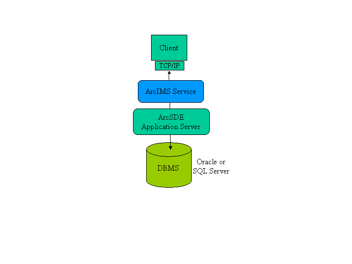
The Spring 2001 issue of ArcNews discusses the ArcSDE Configuration to be as follows for the Internet:
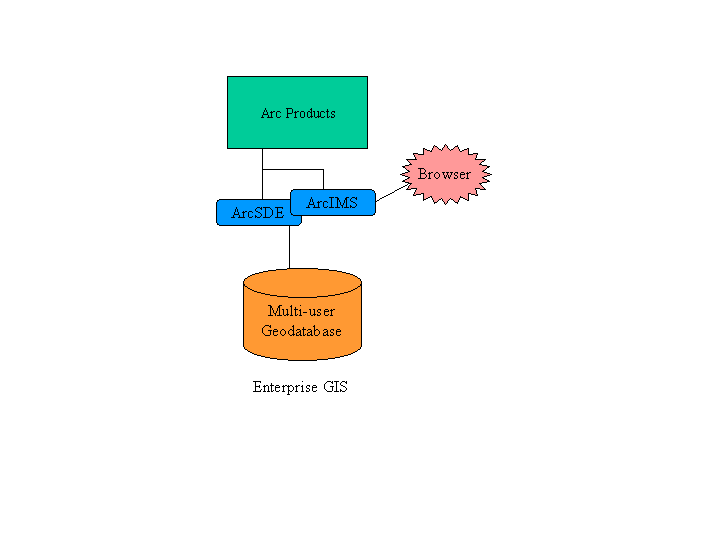
The same issue also describes how the system can be deployed as an enterprise GIS:
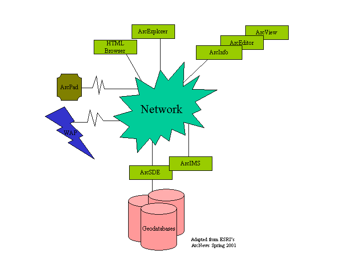
And finally, the ArcGIS solution from ArcNews Spring 2001:
Background information
The 265-acre Millville Research Facility was established in 1972 with funding from the Animal and Plant Health Inspection Service. The primary objective was to facilitate research on the biology and management of coyotes and other predators. It is located approximately 7 miles south of Utah State University among agricultural farmlands (Anderson, 1993). Since it's establishment, it has become a centralized, state-of-the-art fisheries and wildlife research facility. The major types of programs at the facility are ungulates, predators, small mammals and birds, fisheries restoration, stream ecology, wetlands management, education and public outreach, wildlife rehabilitation, and habitat restoration (Anderson, 1993).
Managerial philosophy
The philosophy is that all information be documented as soon as possible as facility personnel begin to retire.
Theoretical Framework - System Development Life Cycle
The theoretical framework delineated here is specifically designed to assist the Millville Research Facility in managing their data and facilities. There is a gap between the actual and the desired ideal states (Sekaran, 2000) of the facility's data management system. Thus, a GIS relational database management system model is under construction. The model will be updated throughout the design phase of the project.
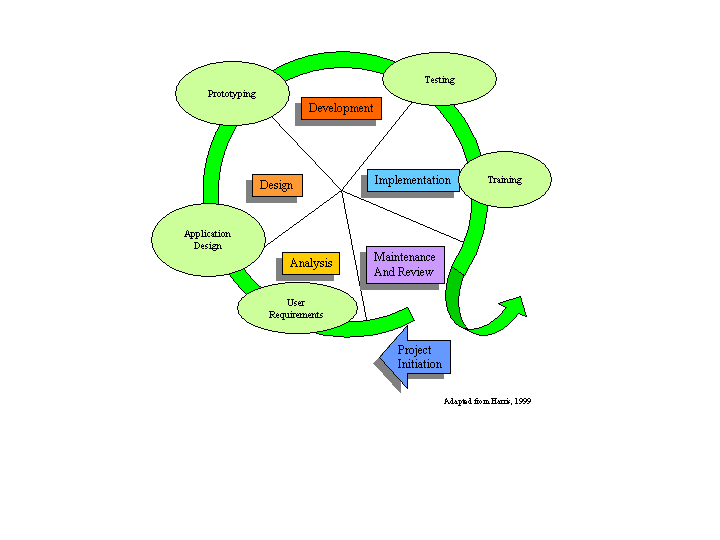
The System Development Life Cycle (SDLC) should be designed to be flexible, adaptable, compatible, and expandable - it should be able to change based on new technologies (Harris, 1999). There are five parts to the SDLC: analysis, design, development, implementation, and maintenance and review.
Analysis
The basic information processing requirements of any project are the driving force behind the design of the information system. These basic information requirements are: relevancy, accuracy, timeliness, usability, affordability, adaptability, and accessibility (Harris, 1999). The information must be relevant to the tasks at hand; the information must be accurate and timely so that managers can use the information for decision-making; the information must be affordable and useable so that the data owners can use the data to make the required decisions. The information must be adaptable to the changing information technology environment and it must be accessible for quick supply or retrieval. These requirements can be addressed and managed through the use of a relational database with a well-defined data model. Fact-finding and diagnosis will be an on-going process throughout the scope of this project. Industry research, online research, interviews with facility personnel, and document reviews will be included in the final version of this research paper.
The Relational Database
A relational database is a collection of files that are tied together by common fields (Harris, 1999). A relational database is being designed for the facility that will assist in managing the data for the site. The database will house the attributes for the spatial data along with non-spatial tabular data. In order to effectively engineer the GIS database management system for the Millville Research Facility, several relational database factors must be understood and implemented. Regardless of the RDBMS chosen for the MRF, the data model will remain the same.
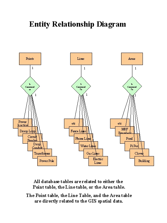
Data models apply an understanding of the properties of data and its uses in the data processing system (Schmidt, 1999). The data model is a picture of the organization plan for the data that flows into, through, and out of information system that focuses on the files of the system (Harris, 1999). The data model documents the entity relationship diagram by defining the Predicates, Classes, and Superclasses of the information system (Schmidt, 1999). The MRF data model will also evaluate the States in which the Classes may transfer. The data model is concerned with one primary objective: find out what data a business works with when the business does what it does (Schmidt, 1999). The basic premise of data modeling is to separate data from the processes. There are two reasons for this: 1) business knowledge properly captured in the database can radiate consistency throughout the applications that rely on it; and 2) the structure of data changes less frequently than the processes change (Schmidt, 1999). In particular, data models do not address the issue of how the data is processed or stored, only what data will be processed and stored.
The Entity Relationship Diagram (ERD) shows the system data files at rest (Harris, 1999). The ERD comprises five ingredients: entities, attributes, relationships, cardinality, and linkages (Harris, 1999). The entity is the data file; the attributes are the items (fields) selected to represent the real world; relationships describe how the data files interact with each other; cardinality is the specific type of relationship the files display in the real world; and linkages are the fields or attributes that the files have in common (Harris, 1999). Appendix B shows the MRF ERD in detail.
Normalization describes the process whereby each file in the database is redesigned so that every attribute within the file is dependent on only the key field for that file. There are two rules: 1) no repeating groups should exist within any file; 2) all many-to-many relationships should be transformed into two one-to-many relationships (Harris, 1999). Appendix C lists the tables for the MRF GIS database systems in 3rd normal form.
The data flow diagram focuses on what the people and procedures do to transform data into information (Harris, 1999). Data flow diagrams identify the data in the system, whether the data is being received or sent and whether it is a data store or data flow. Data stores keep data for later use. The data flow depicts how the information is transported from one place to another (Harris, 1999). The data flow diagram is presently under construction.
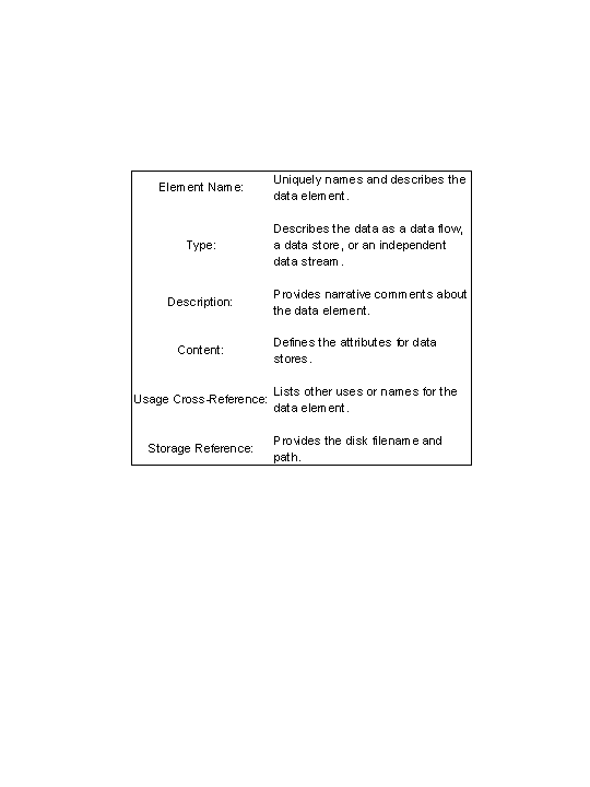
The data dictionary is an ordered catalog of data element names and their definitive characteristics (Harris, 1999). The dictionary will keep the GIS database system designer from duplicating file names or renaming a file in a different part of the system. Entries into the dictionary will have the general appearance at right:
Components of every information system include trained personnel, procedures, software, hardware, and data (Harris, 1999). All computer systems have been designed to assist people in some way. The procedures provide operating and usage instructions for the information system. The software is defined as a series of computer instructions designed to perform a certain task. The hardware consists of all the tangible components of the computer and its peripherals. The data is the system input and information is the system output. The data can be tabular, spatial, or a combination. The geography ties the information systems together from all over the world.
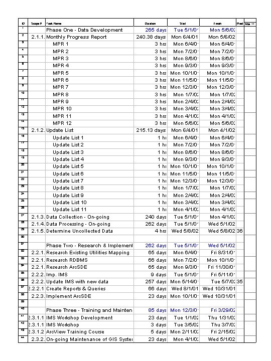
Project Management involves the scope and budget for the entire project. This includes hardware and software costs, costs for labor and sub-contracting, reporting, status tracking, and the project dictionary. The project dictionary is similar to the data dictionary but instead logs all the documents for the project. This dictionary may end up in the RDBMS. See Appendix D for the project Gantt chart.
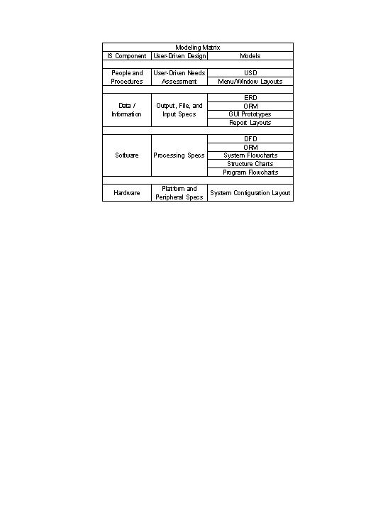
GIS Database System Design
The data model is used in the design phase to assist in the development of the GIS database system prototype. The relational database design is under development and will be evaluated and possibly revised. The models shown in the Modeling Matrix below provide the basis for the design specifications and prototypes that will launch the formal development phase of the SDLC (Harris, 1999). At this time, only the ERD has been developed (see Appendix B). Further analysis and design will occur to develop the User's System Diagram (USD), the Object Relational Model (ORM), and the Data Flow Diagram (DFD). These diagrams and subsequent layout designs will be built in the design phase of the project. At the conclusion of the design phase, a design report and presentation will be created with the following information (Harris, 1999):
1) Overview of the New System Design - DFD, ERD, ORM, USD, User Interface Design
2) Hardware and Software Specifications - cost estimates
3) Cost/Benefit Analysis
4) Project Budget
5) Project Status Report
6) Appendices - Input and output prototype samples
As yet, it has not been determined how new information will be input into the GIS database management system. Several options are available: 1) the information will be input by the person generating the information; 2) the information will be input by a data entry clerk; or 3) the information will be input by the GIS database system designer. Some further analysis and discussion is required on this issue due to the opportunity for corruption of data when multiple people have access to the database. This decision can be made by using Harris' eight design evaluation criteria:
1) End-user orientation
2) Understandability
3) Expandability
4) Security
5) Execution speed
6) Expense to develop
7) Time to develop, and
8) Accessibility
GIS and database reports will be designed for the end user. Analysis of the interviews with facility personnel will dictate the information required on a regular basis. This information will then be designed into a report that can be generated when needed. The data dictionary will be updated with all new documents generated. Forms, reports, and files will be designed with security, speed, and efficiency in mind.
A prototype will be developed for the GIS database system. It will be fully functional and will encompass the basic design for all reports and queries. The general design and functionality will be built and presented for review and comments. Prototype development is a part of the design phase and the development phase.
Development
Development of a GIS database management system prototype will take place in this phase. Prototyping is a model or pattern of a product (Harris, 1999). ArcIMS will be fused with SDE and a RDBMS. The RDBMS will be chosen based on the variables evaluated in section five. The prototype will be fully functional, as all aspects of it will be used in the final implementation. The prototype will assist in further refining the needs of the facility and will begin the training of the personnel involved in the process. The personnel will become familiar with the product and become well versed in the capabilities of the software thus enabling them to request changes to the overall design of the final product. The prototype will also funnel design changes into this phase of the process instead of post implementation. The prototyping steps that Harris suggests are:
1) Identify prototyping candidates such as user interfaces, master and transaction file maintenance, and simple processing functions,
2) Build the prototypes with tools such as 4GL, graphics, and presentation software
3) Test the prototypes to ensure that they can easily be accessed for demonstrations
4) Prepare a prototype USD to identify the parts of the system that are prototyped
5) Collaborate with the user to evaluate the prototype and make changes where necessary
6) Transform the prototype into a working system.
The prototype will apply the ERD, DFD, and USD models along with the report and GUI designs.
Implementation
Implementation of the GIS database management system will pull the final, revised design prototype into the preliminary implementation. Any minor changes needed at this time will be made and incorporated into all documentation. Final implementation will occur by May 2002. This will include a MRF web page with a link to the ArcIMS map server that will access SDE and a RDBMS. The implementation will also include reports, popular queries, and data entry forms. The RDBMS will be in 3rd normal form and will have triggers and input controls on all tables. Documentation will also be finalized with the data dictionary and training materials.
The system documentation is a collection of information that provides a detailed history of the system development life cycle (Harris, 1999). It will include the history of the development of the system and comments by the system designer.
Training documentation and a one-day training session will be developed upon completion of the implementation of the IMS with SDE and the RDBMS. Harris suggests incorporating the following information in the training manual:
1. Training objectives
2. Schedule of training activities
3. Information system overview including a narrative, the system diagrams (USD), and the menu tree
4. Outline of instructor demonstrations
5. Outline of hands-on activities
6. Quick reference guide
7. Copies of handouts and overheads
8. Questions and answer notes.
A Procedures manual, sometimes called a User's Guide, will also be developed for this project. This manual will contain detailed instructions about the GIS database management system and how to obtain assistance. Harris lists the following as a procedures manual table of contents:
1) Information System Description
2) System Operating Instructions
3) System Input And Output Samples
4) Emergency And Security Instructions
5) Appendix A. 4GL Software Specifications
6) Appendix B. Platform Specifications
7) Appendix C. System Error Messages
8) Appendix D. Definitions
Maintenance & Review
After implementation, a review process will be held in which the users may describe problems or issues that have arisen. Software version upgrades will occur and testing will be conducted to ensure that no errors have been introduced with the new versions. Data will continue to be updated at a level and scale to be determined at a later date.
Theoretical Framework - Variables
The variables that affect the RDBMS decision must be clearly identified, defined and labeled. This section of the theoretical framework is a conceptual model of how one theorizes or makes logical sense of the relationships among the several factors that have been identified as important to the problem (Sekaran, 2000). The theoretical framework discusses the interrelationships among the variables that are deemed to be integral to the dynamics of the situation being investigated (Sekaran, 2000). Sekaran states that the five basic features for all theoretical frameworks are:
1) The variables
2) How the variables are related
3) The nature and direction of the relationships
4) Why we expect these relationships to exist
5) A schematic diagram of the framework
From the theoretical framework, testable hypothesis can be developed to examine whether the theory formulated is valid or not. The variables are any measurable concept or item that can take on differing values. There are four types of variables - dependent, independent, moderating, and intervening, which can be discrete (gender) or continuous (age) (Sekaran, 2000).
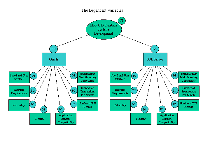
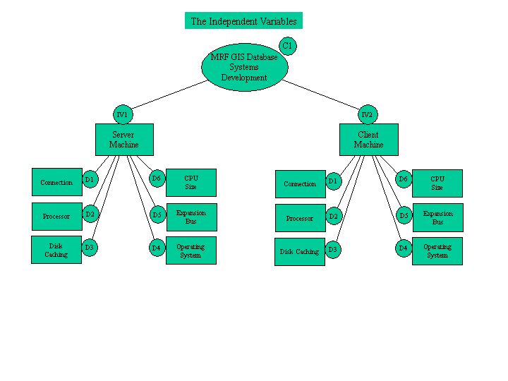
The variables have been determined by the nature of the research. In this case, the dependent variables are the two RDBMSs that are under review. The independent variables have been determined to be the computer systems upon which the GIS database management systems are run. In this case, there are two independent variables because the computer system running the ArcIMS, SDE, and RDBMS will have an effect on how fast the information is served to the client whose system will determine how fast it can receive and process the information. These variables are related in such a way that if Oracle is chosen and the server is not robust enough to handle the software, the system performance will not be optimal and the client side will become frustrated. If SQL Server is chosen and the facility has too much data, then the system will not perform efficiently for the site. If the hardware does not perform optimally, the software cannot perform optimally. If the hardware operates under top performance conditions, then the software should be expected to operate at its top performance level. These variables are inextricably linked due to the nature of the relationships between software and hardware. The hardware must be capable of running the software in an efficient, speedy manner; otherwise, the hardware must be upgraded. The software must be loaded on to hardware in order to perform its function. Two schematic diagrams can be reviewed on the following pages. The first addresses the Dependent Variables and the second addresses the Independent Variables. At this time, no moderating or intervening variables have been identified.
The Dependent Variable is of primary interest in research. The Dependent Variable is the main variable that lends itself as a viable factor for investigation. Through the analysis of the Dependent Variable, it is possible to find answers or solutions to the problem (Sekaran, 2000). Each variable has dimensions, or broad characteristics that are typical of the variable and can be measured. If the dimension of a variable is not measurable, the dimension is further broken down into elements which are then measured.
Dependent Variable - Oracle
Dimension 1 - Speed and user interface
Dimension 2 - Resource requirements (disk and RAM)
Dimension 3 - Reliability
Dimension 4 - Security
Dimension 5 - Application software compatibility
Dimension 6 - Number of records db can store
Dimension 7 - Number of transactions per minute (TPM)
Dimension 8 - Multitasking and multithreading capabilities
Dependent Variable - SQL Server
Dimension 1 - Speed and user interface
Dimension 2 - Resource requirements (disk and RAM)
Dimension 3 - Reliability
Dimension 4 - Security
Dimension 5 - Application software compatibility
Dimension 6 - Number of records db can store
Dimension 7 - Number of transactions per minute (TPM)
Dimension 8 - Multitasking and multithreading capabilities
The Independent Variable influences the dependent variable in either a positive or negative way (Sekaran, 2000).
Independent Variable- Computer system on which the GIS database system runs (Server side)
Dimension 1 - Connection
Dimension 2 - Processor
Dimension 3 - Disk caching
Dimension 4 - Operating System
Dimension 5 - Expansion bus
Dimension 6 - CPU size
Independent Variable- Computer system the client accesses the IMS from (Client side)
Dimension 1 - Connection
Dimension 2 - Processor
Dimension 3 - Disk caching
Dimension 4 - Operating System
Dimension 5 - Expansion bus
Dimension 6 - CPU size
The Moderating Variable has a strong contingent effect on the Independent-Dependent variable relationship. It modifies the original relationship between the Independent and Dependent variables (Sekaran, 2000). At present, no Moderating Variables have been identified.
The Intervening Variable has a temporal affect on the variable relationships. No Intervening Variables have been identified at this time.
Research Design
The type and nature of this study is basic, state-of-the-art research to learn more about ArcIMS, the Spatial Database Engine, and two RDBMSs. The information gathering on ArcIMS and SDE is a descriptive study with an exploratory twist. The research on Oracle and SQL Server is exploratory in nature. The entire Millville Research Facility GIS Database Management System is exploratory in nature.
The purpose of the study is part descriptive and part exploratory. Descriptive studies are undertaken in order to ascertain and be able to describe the characteristics of the variables of interest in a situation (Sekaran, 2000). They describe relevant aspects of the phenomena of interest from an individual, organizational, industry-oriented, or other perspective. Studies that present data in a meaningful form thus help to 1) understand the characteristics of a group in a given situation, 2) think systematically about aspects in a given situation, 3) offer ideas for further probe and research, and 4) help make certain simple decisions about the issue (Sekaran, 2000). Exploratory studies are undertaken when not much is known about the situation at hand, or when no information is available on how similar problems or research issues have been solved in the past (Sekaran, 2000). They are generally undertaken to better comprehend the nature of the problem. Exploratory studies are important for obtaining a good grasp of the phenomena of interest and for advancing knowledge through good theory building and hypothesis testing (Sekaran, 2000).
Data collection methods are through the use of Trimble GPS units, hard and soft copy data sets, on-site meetings and interviews. White papers, technical workshops, and training courses will also assist in the development of data to determine which RDBMS will best suit the facility. Data collection will continue throughout the project timeframe through the use of primary data sources.
This study is being conducted in a non-contrived, field study setting. This means that the RDBMS testing will occur in a typical office setting with typical office equipment and software. It is a correlational type of investigation. In a correlational study, the researcher is interested in delineating the important variables that are associated with the problem (Sekaran, 2000). There will be no manipulation or control by the researcher in this study.
Temporal aspects or the time horizon is cross-sectional because the RDBMS data will be gathered just once. However, the time horizon for the entire project and the collection of GIS data is longitudinal at 12 months. The level at which data will be analyzed or the unit of analysis is a dyad of software packages. However, when ArcIMS and SDE are included in the study, the unit of analysis moves to the group level.
The variables will be measured through the testing of the software using the data model designed in the analysis and design phase of the SDLC. During testing, additional variables may become apparent while others may be deemed unnecessary.
Conclusions
After conducting the abbreviated literature review, searching the Esri User Conference proceedings, and developing the System Development Life Cycle, it becomes very apparent that much work remains to be conducted. The User Systems Diagram will need to be developed along with the Data Flow Diagram and the Object Relational Model. Interviews and meetings with other organizations who have implemented a system similar to the MRF GIS database management system still need to be held. The testing of the RDBMSs will take place in Fall 2001. Training of system designer personnel will also occur, both at the 21st Annual Esri User Conference and through individual training courses.
It has become apparent that ArcIMS and ArcSDE will function well together. It seems that both Oracle and SQL Server will also work well with these two Arc software packages. The decision will be made using Harris' eight design evaluation criteria. Utah State University maintains a site license with Esri which will allow the use of ArcGIS and all the associated components. USU also has a site license agreement with both Microsoft and Oracle. This will allow for a minimal payment towards the license and should not hinder the decision-making process.
Additionally, many similar projects have incorporated Automated Mapping/Facilities Management (AM/FM) software into the design of the system. This type of software may facilitate the capture of the spatial and tabular data for the Millville GIS database management system. The AM/FM component may be an additional variable that could be added to this research. Additional information gathering is required before actually including it as a variable in the research.
Finally, the GIS Database Management System training course must be developed along with training materials and project documentation. Project completion is scheduled for May 2002.
Please visit the RS/GIS Laboratories web page at: www.gis.usu.edu
You may reach me via email at: pjp@cnr.usu.edu
Ms Pratt is Project Director in the Department of Geography and Earth Resources' Remote Sensing and GIS Laboratories, College of Natural Resources, Utah State University.
Acknowledgments
I would like to thank Chuck Gay for obtaining the funding and providing the support for this project. I would also like to thank my major professor, Dr. David Paper, Assistant Professor, Business Information Systems, Utah State University, for teaching me about research and assisting me in compiling this document. I thank the Remote Sensing & GIS Laboratories, CNR, for the use of their equipment and space. And, last but certainly not least, I thank my husband, Mr. Glen Lyon, Applications Engineer for Campbell Scientific, Inc. for standing beside me and supporting me through this process.
References
Sekaran, Uma (2000). Research Methods for Business A Skill Building Approach. Third Edition. New York, NY: John Wiley and Sons, Inc.
Anderson, David T. (1993). Master Plan: Conceptual Design and Master Planning for the Fisheries & Wildlife Research Center, College of Natural Resources, Utah State University. Logan, UT: Department of Landscape Architecture and Environmental Planning, Utah State University.
Schmidt, Bob, Warren, David (Ed.). (1999). Data Modeling for Information Professionals. Upper Saddle River, NJ: Prentice-Hall.
Harris, David (1999). Systems Analysis and Design for the Small Enterprise. Second Edition. Orlando, FL: Harcourt Brace & Company.
Environmental Systems Research Institute, Inc. (1999-2000). Introduction to ArcSDE. Redlands, CA.
Esri, Inc. (2001). Intersecting Technologies Create Location Services. ArcUser, April - June 2001, 10-12.
Koeppel, Ian (2001). Location Services are Here Now. ArcUser, April - June 2001, 14-17.
Clark, Timothy E. (2001). GIS Provides Critical Support for Wildfire Response. ArcUser, January - March 2001, 18-20.
Torrieri, Nancy, and Holland, Jennifer (2000). Census Sense, Part 3 Enabling an Annual Census. GeoSpatial Solutions, November 2000, 38-42.
Corbley, Kevin (2000). Government That Works. GeoWorld, December 2000,40-42.
Corbley, Kevin (2001). Ottawa County, Michigan, Sets Fair Fees for Online GIS Products. ArcNews Spring 2001, 22.
Esri, Inc. (2001). GIS In Action. ArcNews Spring 2001,10-11
Appendix A: Millville GIS Database Systems Tabular Data List
Physical features:
Irrigation risers on Millville Canyon irrigation line
Diversion box on Millville Canyon irrigation line
Water diversion points on Millville-Providence Canal
Gates to all of the animal pens
10 at rabbit pens
3 at each set of Clover pens
6 at Pi pen
3 at South-40 pens
Electrical:
Lines
Overhead, 2-phase
Underground, 2-phase
Underground, 3-phase
Overhead, 3-phase
Electrical points
Power poles:
1. Power pole
2. Power pole, w/ transformer, drop conduit
3. Power pole, w/ drop conduit to Admin. Bldg. Transformer
6. Well head, circuit breaker box
7. Power pole
8. Power pole
9. Power pole
10. Power pole, w/ transformer, drop conduit to Clover 11, droop loop to Pi Pen Bldg.
11. Power pole
12. Power pole
13. Power pole w/ junction
14. Power pole w/ transformer, droop loop to Clover 3
15. Drop conduit, outside breaker box with main feeds to Clover 3 & via drop conduit to Clover 4 & 5, inside breaker box for Clover 3
16. Power pole
17. Power pole, w/ transformer, droop loop to South-40 Tower
18. Drop conduit, inside breaker box
Transformers:
2. Transformer, drop conduit (3-phase) to Research support building;
2. Drop conduit to caretaker residence
3. Drop conduit (3-phase) to Transformer by Administration/research building
4. Transformer (pedestal)
10. Transformer, droop loop to Pi Pen weather head; 10. drop conduit to Clover complexes 7-12
14. Transformer, droop loop to Clover 3 weather head
17. Transformer, droop loop to South-40 weather head
Electric meters:
4. Electric meter for administration/research bldg.
5. Electrical meter for pumps for fish ponds
15. Electric meter for Clovers 3 - 5
18. Electric meter for South-40 Tower
26. Electric meter for Clovers 7 - 12
27. Electrical meter for Pi Pen
28. Electric meter for Research support building
29. Electric meter for Caretaker residence
Circuit breaker boxes:
23. Outside breaker box for main feeds to Clovers 7, 8, 9; Outside breaker box for Clover 8
24. Outside circuit breaker box for Clover 10
25. Outside circuit breaker box for Clover 12
26. Outside breaker box for main feeds to Clovers 10, 11, 12; Outside breaker box for Clover 11
21. Outside circuit breaker box for Clover 7
22. Outside circuit breaker box for Clover 9
28. Inside circuit breaker box for Clover 5
29. Inside circuit breaker box for Clover 4
15. Outside breaker box for main feeds to Clovers 3, 4, and 5; Inside circuit breaker box for Clover 3
Telephone:
Lines:
1. 25 pair (?) Trunk line comes from west (Hollow Road) to Pedestal (T1)
2. Underground line from pedestal T1 to Research support building
3. Underground line from along outside of RSB to west corner and then to pedestal by caretaker residence
4. Underground line from T1 pedestal to Administration/research building at unknown location (Blue Stake can identify)
Telephone points:
T1. Main telephone pedestal
T2. Telephone pedestal for caretaker residence
T3. Telephone pedestal for Research support bldg.
T4. Telephone pedestal for Administration/Research bldg.
Natural Gas
Lines:
Sizes undefined
Locations only approximate (need blue stake)
Points:
G1. Natural gas meter for caretaker residence
G2. Natural gas meter for Research support building
G3. Natural gas meter for Administration/research building
Water Features:
Lines:
See maps for locations, sizes, and types
Need to use GPS to map irrigation line from Millville Canyon
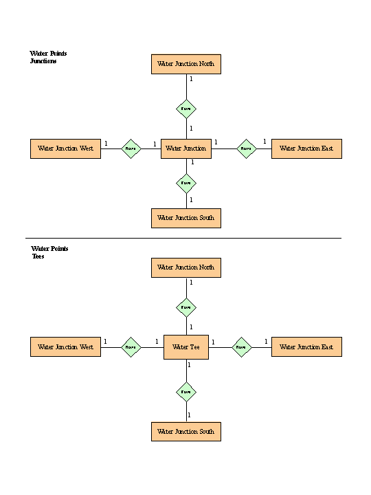
Water points:
Junctions:
1. 6" PVC
north 6" PVC
east 4" PVC with valve
south 4" PVC
west 6" PVC
2. 4" PVC
north 4" PVC stub & cap
east 4" PVC with valve
south 4" PVC with valve
west 4" PVC
3. 4" PVC
north 4" PVC stub & necked down to air relief valve
east 4" PVC
south 2" PVC
west 4" PVC
4" PVC
north 4" PVC stub & cap
east 4" PVC with valve
south 4" PVC with valve
west 4" PVC
5. 4" PVC
north 4" PVC stub & cap
east 4" PVC stub and necked down to air relief valve
south 2" PVC with valve
west 4" PVC
6. 4" PVC
north 4" PVC
east 2" PVC with valve
south 4" PVC
west 4" PVC stub and cap
7. 4" PVC
north 4" PVC
east 4" PVC capped (?)
south 4" PVC
west 4" PVC
8. 4" PVC
north 4" PVC
east 2" PVC with valve
south 4" PVC
west 4" PVC stub and capped
9. 4" PVC (don't know if this exists or what it is)
10. 4" PVC
north 4" PVC
east 2" PVC stub with valve
south 4" PVC
west 4" PVC stub and capped
11. 4" PVC
north 4" PVC
east 4" PVC
south 4" PVC stub and capped (?)
west 4" PVC stub and capped (?)
12. 6" PVC
north 4" PVC with valve
east 6" PVC
south 2" PVC with valve
west 4" PVC (with valve?)
13. 2" PVC
northeast 1" PVC with valve to Clover 7
southeast 2" PVC
southwest 1" PVC with valve to Clover 9
northwest 2" PVC
14. 2" PVC
north 1" PVC with valve to Clover 10
east 2" PVC
south 1" PVC with valve to Clover 12
west 2" PVC
15. 4" PVC Tee
east 4" PVC
south 1" PVC with valve to Clover 5
west 4" PVC
16. 4" PVC Tee
north 1" PVC with valve to Clover 3
east 4" PVC
west 4" PVC
17. 4" PVC Tee
east 4" PVC
south 1" PVC with valve to Clover 4
west 4" PVC
18. 4" PVC Tee
north 2" PVC with valve
east 4" PVC
south 2" galvanized with valve
west 2" galvanized with valve
Water delivery points:
1. 4" fire hydrant: 1.5" stub and valve (for eventual line to rabbit pens)
2. 1" hydrant and shutoff valve for Clover 7 "lixit" line
3. 1" hydrant and shutoff valve for Clover 8 "lixit" line
4. 1" hydrant and shutoff valve for Clover 9 "lixit" line
5. 1" hydrant and shutoff valve for Clover 10 "lixit" line
6. 1" hydrant and shutoff valve for Clover 11 "lixit" line
7. 1" hydrant and shutoff valve for Clover 12 "lixit" line
8. 1" hydrant
9. Shutoff valve for P>i Pen "lixit" line
10. 1" hydrant
11. 1" hydrant
12. 1" hydrant
13. 1" hydrant
14. 2" stub and capped (for hookup to 3 watering troughs)
15. 1" hydrant and shutoff valve for Clover 5 "lixit" line
16. 1" hydrant and shutoff valve for Clover 3 "lixit" line
17. 1" hydrant and shutoff valve for Clover 4 "lixit" line
18. 1" hydrant
19. 1" hydrant
20. 1" hydrant
21. 1" hydrant
22. 1" hydrant
23. 1" hydrant
24. 1" hydrant
25. 4" fire hydrant
26. 1" hydrant
27. 1" hydrant
28. 1" hydrant
29. 1" hydrant
30. 1" hydrant
31. 1.5" valve for east kennel flush line
32. 1.5" valve for west kennel flush line
33. 1.5" valve for abandoned line heading southwest (toward residence)
34. Abandoned water meter under fence
35. 1" hydrant inside bio-energetics pen
36. 1" hydrant
37. Water reservoir w/ three 6" valves
1 valve (normally closed) drains from reservoir floor into overflow pit
1 valve (normally open) services the culinary water supply for facility (using this valve leaves about 7,000 gallon emergency reserve
1 valve (normally closed) accesses reserve 7,000 gallons to culinary system
Septic tanks:
1. South of Research support building
2. East of Kennel 1 (two tanks in tandem)
3. East of Kennel 2
4. West of Caretaker residence
5. North of Administration/research building
6. Immediately west of Pi pen observation building
Appendix B: Entity Relationship Diagram
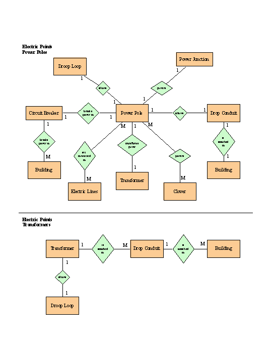
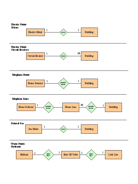
Appendix C: Normalized Tables
Power Pole TableAppendix D: Project Gantt Chart