This study identifies how the Regional Public Transportation Authority (RPTA), in Phoenix, AZ, employed GIS to analyze the effects of consolidating multi-city public paratransit systems that have inconsistent zone areas, hours of operation and fare requirements. GIS was used in this project to identify the "winners" and "losers" of potential zone and fare changes resulting from the consolidation. The analysis was instrumental in guiding the regional project team in developing reasonable alternatives. This study will illustrate how GIS tools can be used to solve specialized public transportation problems.
The Phoenix metropolitan area has a population of over 3 million, with a geographic land area of 9,226 sq. miles. There are 26 different incorporated communities within this area. Due to the many geographic and political boundaries that exist, the delivery of public transportation services is difficult for the transportation service providers and confusing for passengers. To help unify the public transit systems in the region, the Valley Metro identity was created in 1993. Public transportation services provided under the Valley Metro identity include fixed route bus, paratransit (a.k.a. dial-a-ride) service, vanpool, and regional rideshare programs.
While public transportation in the Phoenix metropolitan area is comprised of many different sub-modes, this paper focuses only on paratransit service, which is also known as dial-a-ride. The Valley Metro Dial-a-Ride Policies and Procedures Manual describes paratransit as a form of "public transportation service designed to provide mobility to the elderly and persons with disabilities, including the complimentary service component as part of the Americans with Disabilities Act of 1990. Paratransit is a shared ride door-to-door service that serves passengers in a number of different ways including advanced reservations, recurring/repetitive trips, and demand response transportation" (Valley Metro, pg. 4).
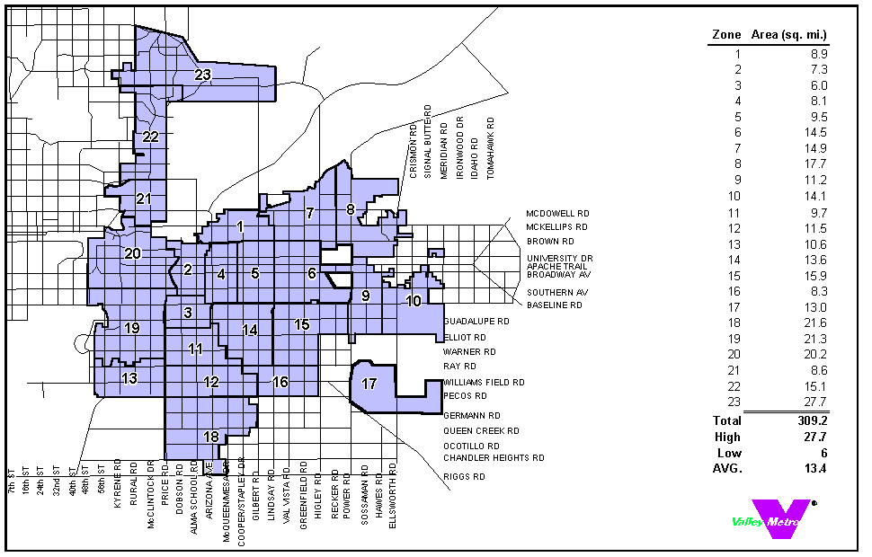
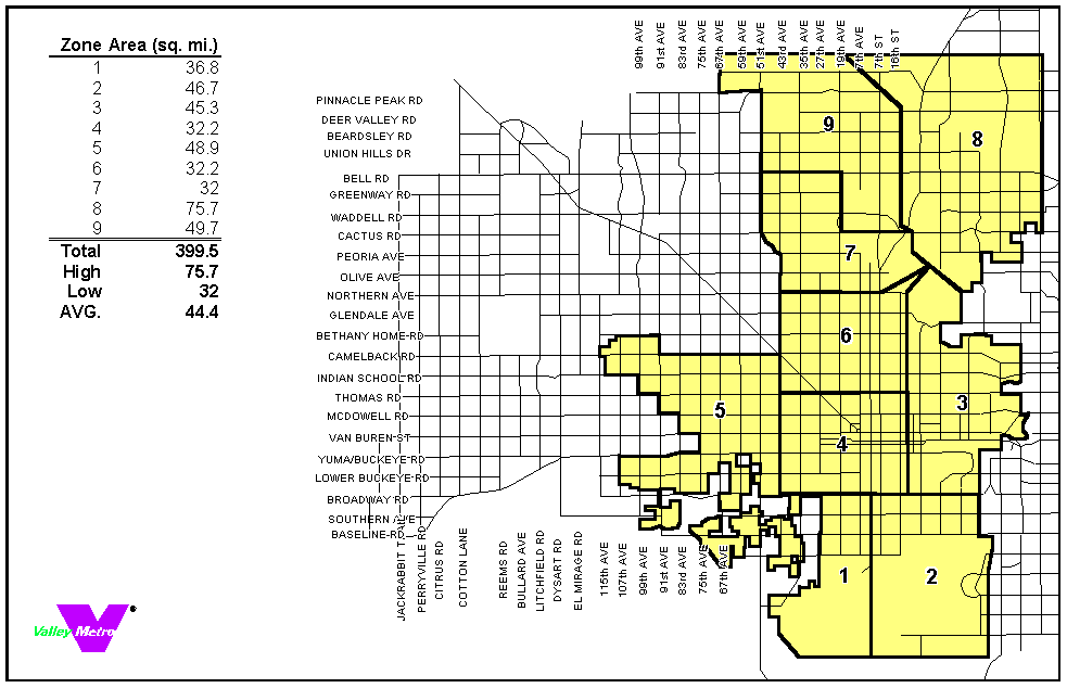
Valley Metro is sub-divided into several local paratransit systems. Each local paratransit system operates within it's own service area, which are typically based upon jurisdictional boundaries. This division of service requires passengers to make multiple transfers and connections to travel to destinations beyond their local community's borders. The two paratransit systems analyzed in this study are identified as the East Valley Dial-a-Ride (EVDAR) and the Phoenix Dial-a-Ride (PHXDAR). EVDAR is unique from PHXDAR because it is comprised of five different communities, while PHXDAR is based upon a single jurisdiction. Figures 1 and 2 illustrate the service area and zone boundaries of EVDAR and PHXDAR respectively.
Although EVDAR and PHXDAR operate under the Valley Metro identity, each are administered separately and have different operating characteristics. Both systems are sub-divided into zones, which are used to determine fares and to calculate maximum ride time. However, both EVDAR and PHXDAR evolved prior to the creation of Valley Metro, resulting in inconsistent zone sizes and fares. Since fares are based upon the number of zones in which a passenger travels, the EVDAR and PHXDAR charge different fares to compensate for the variation in zone size.
The purpose of this study was to analyze the effects of implementing a uniform zone and fare structure between the EVDAR and PHXDAR paratransit systems. Geographic Information System (GIS) technology was used in the analysis to determine the effects of either re-aligning or consolidating zone boundaries and implementing a uniform passenger fare structure based upon typical travel patterns.
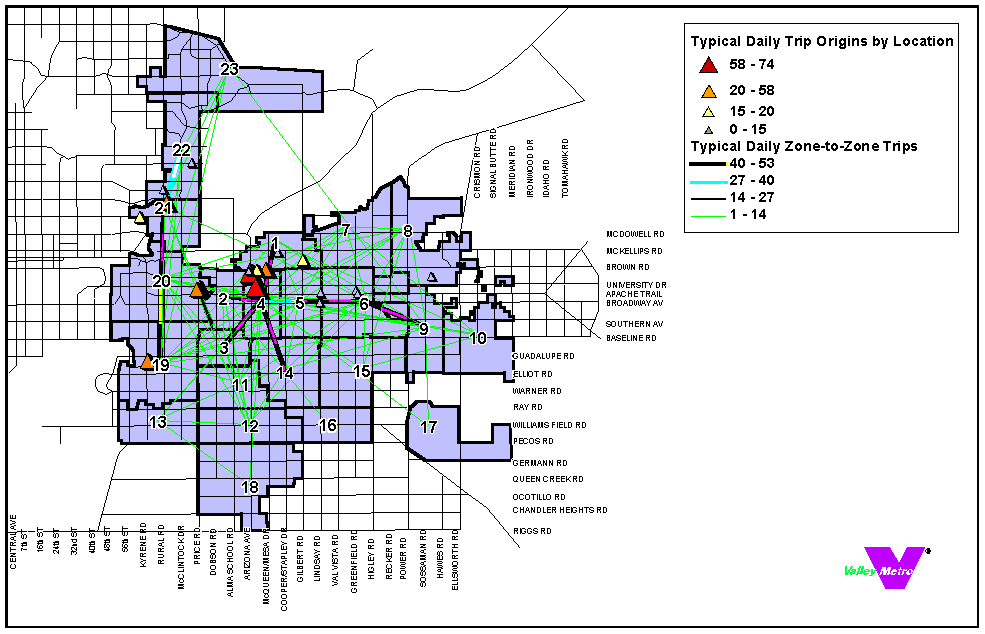
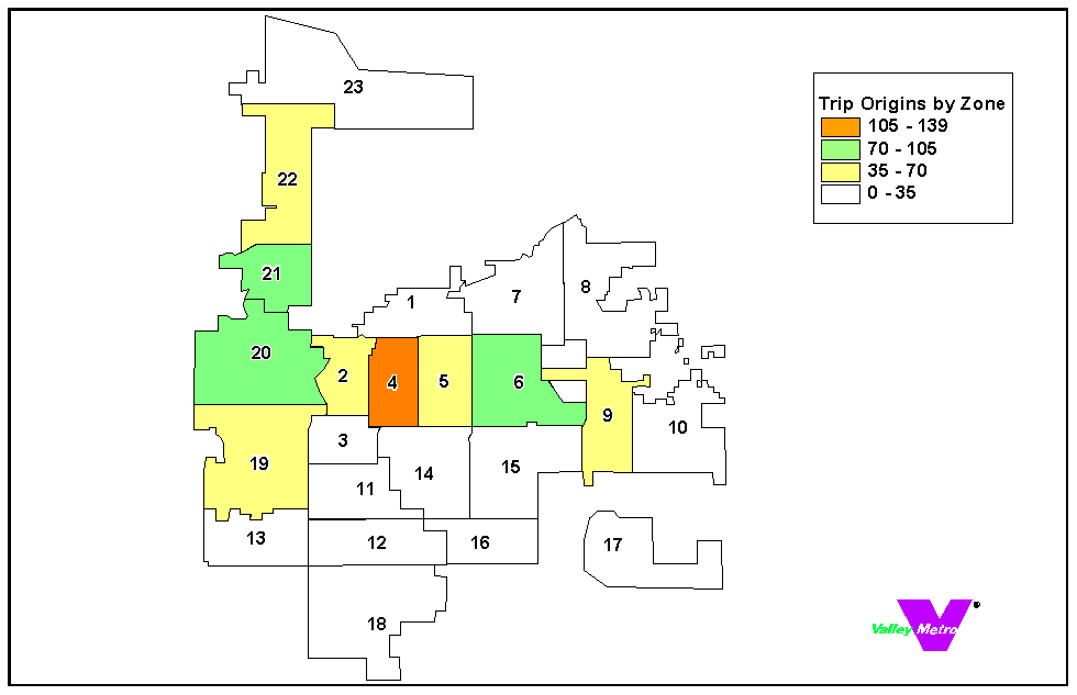
The passenger travel pattern data used in this report was generated from actual trips that were provided by EVDAR and PHXDAR on January 20th, 2000. Additional days were not used in this analysis because the sample data represented a typical operating day. EVDAR provided electronic passenger travel data obtained from their computer aided dispatch system. During the time of the study PHXDAR did not have electronic data available, therefore passenger travel information had to be entered into a computer database manually. Origin and destination data were plotted using Esri's ArcView GIS to show travel patterns within and between zones. In addition, hypotenuse lines (as the crow flies) were displayed in GIS to help planners and decision-makers visualize typical travel patterns. Figures 3 & 4 illustrate typical EVDAR passenger travel patterns, within the existing zone system. Figure 3 is a GIS map that highlights zone of origin, while figure 4 illustrates points of origin within zones and zone-to-zone travel activity. Based upon these findings, alternatives concerning zone re-alignment and consolidation were developed. Furthermore, trip patterns were used to analyze the effect of zone alternatives upon passenger fares and agency revenues.
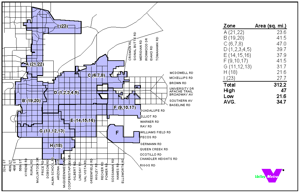
Currently, EVDAR and PHXDAR are the only paratransit providers in the region that operate zone-based systems. Because of the variation in zone size, it would be difficult to develop a consistent fare structure between the two systems unless the average zone sizes were similar. The project team (see acknowledgements) originally proposed two alternatives for zone re-alignment within the East Valley Dial-a-Ride only. Each of the alternatives were based on increasing the size of the zones within the EVDAR to more closely match the size of the zones in the PHXDAR. Additional criteria such as travel patterns and jurisdictional boundaries were considered. Of the two alternatives created, only one was advanced for additional analysis. The preferred alternative (Figure 5), having an average zone size of 34.7 square miles, was used in additional analyses to determine the effects of restructuring fares. This alternative, which favors zone consolidation over re-alignment, was selected for further review based upon passenger travel patterns identified using GIS, while remaining cognizant of political boundaries.
The results of the zone consolidation for the EVDAR system were not surprising. With an increase in overall zone size and a reduction in the total number of zones, the project team expected that the total revenue collected and the average revenue collected per trip would decrease. The GIS analysis indicated that existing total daily revenue was approximately $1,200, while projected revenue under the proposed zone system would only generate about $960. Likewise, the average revenue collected per trip reduced from approximately $1.50 to $1.20. Due to agency concerns regarding loss of revenue, alternative fare structures were evaluated.
Just as zone sizes are dissimilar between the regional paratransit systems, so are the fare structures that each administer. The demand response fare for EVDAR is currently $1.00 for the first zone, plus $.50 for each additional zone traveled, while PHXDAR's fare is $1.20, plus $.60 for each additional zone. Table 1 illustrates the inconsistent fare structures among all of the Valley Metro paratransit providers, including EVDAR and PHXDAR. Table 2 identifies the farebox recovery, shown as a percentage of operating costs, of each of the Valley Metro paratransit systems in Fiscal Year 1999. Originally, six passenger fare alternatives were analyzed. The impact of revenue was determined based upon each of the passenger fare alternatives. Two alternatives were identified for further consideration. Table 3 illustrates the impact of the alternative fare and zone changes upon agency revenue and individual passenger fares.
|
Senior |
ADA |
General Public |
Students |
AVG. Collected Fare FY99 |
||||
|
Dial-a-Ride |
Base Fare |
Zone Fare |
ADA Fare |
Base Fare |
Zone Fare |
With Transfer |
Base Fare |
|
|
East Valley |
$1.00 |
$0.50 |
$2.00 |
--- |
--- |
--- |
--- |
$1.31 |
|
El Mirage |
$0.75 |
--- |
--- |
--- |
--- |
--- |
--- |
$0.64 |
|
Glendale |
$1.00 |
--- |
$2.00 |
$2.00 |
--- |
--- |
$1.00 |
$1.07 |
|
Paradise Valley |
--- |
--- |
$2.50 |
--- |
--- |
--- |
--- |
NA |
|
Peoria |
$1.00 |
--- |
$2.00 |
$3.00 |
--- |
--- |
$1.00 |
$1.18 |
|
Phoenix |
$1.20 |
$0.60 |
$2.40 |
$2.40 |
$1.20 |
--- |
--- |
$1.82 |
|
SCAT |
$2.50 |
--- |
$2.50 |
$2.50 |
--- |
--- |
--- |
$2.28 |
|
Surprise |
$1.00 |
--- |
--- |
$1.00 |
--- |
$1.25 |
$0.00 |
$0.95 |
|
Average |
$1.21 |
$0.55 |
$2.23 |
$1.98 |
$1.20 |
$1.25 |
$0.67 |
$1.52 |
|
High |
$2.50 |
$0.60 |
$2.50 |
$2.50 |
--- |
--- |
$1.00 |
$2.28 |
|
Low |
$0.75 |
$0.50 |
$2.00 |
$1.00 |
--- |
--- |
$0.00 |
$0.64 |
Table 1 Notes: Guadalupe and Maricopa County have been excluded from this chart because their fares are on a donation basis only. Glendale, Peoria and Surprise offer discount fares to students age 6 -12 (13 in Glendale).
|
Dial-a-Ride |
FY 1999 Farebox Recovery |
|
East Valley |
11.2% |
|
El Mirage |
4.5% |
|
Glendale |
6.2% |
|
Paradise Valley |
NA |
|
Peoria |
9.2% |
|
Phoenix |
6.8% |
|
SCAT |
28.4% |
|
Surprise |
9.7% |
|
Average |
9.6% |
|
High |
28.4% |
|
Low |
4.5% |
|
East Valley DAR |
Phoenix DAR |
||
|
Based on Current Fares |
Existing Zones |
Proposed Zones |
Existing Zones |
|
Sample Size (1) |
795 |
795 |
140 |
|
Intra-Zone Trips |
289 |
515 |
86 |
|
Percent Intra-Zone |
36.4% |
64.8% |
61.4% |
|
Total Revenue Collected |
$1,193.50 |
$961.50 |
$207.00 |
|
Avg. Rev. Collected/Trip |
$1.50 |
$1.21 |
$1.48 |
|
Trips with no Passenger Fare Change |
NA |
412 |
NA |
|
Trips with a Passenger Fare Increase |
NA |
0 |
NA |
|
Trips with a Passenger Fare Decrease |
NA |
383 |
NA |
|
Proposed Fare Increase: $1.25 first zone plus $.50 each additional zone (Based on current fixed route base fare) |
Passenger could pay up to $.25 more, or save up to $1.25 |
Passenger could pay up to $.05 more, or save up to $.15 |
|
|
Trips with no Passenger Fare Change |
0 |
0 |
0 |
|
Trips with a Passenger Fare Increase |
795 |
412 |
86 |
|
Trips with a Passenger Fare Decrease |
0 |
383 |
54 |
|
Total Revenue Collected |
$1,392.25 |
$1,160.25 |
$207.50 |
|
Avg. Rev. Collected/Trip |
$1.75 |
$1.46 |
$1.48 |
|
Proposed Fare Increase: $1.20 first zone plus $.60 each additional zone (Based on Current Phoenix DAR Fare Structure) |
Passenger could pay up to $.40 more, or save up to $1.60 |
||
|
Trips with no Passenger Fare Change |
0 |
1 |
140 |
|
Trips with a Passenger Fare Increase |
795 |
412 |
0 |
|
Trips with a Passenger Fare Decrease |
0 |
382 |
0 |
|
Total Revenue Collected |
$1,432.20 |
$1,153.80 |
$207.00 |
|
Avg. Rev. Collected/Trip |
$1.80 |
$1.45 |
$1.48 |
The project team used GIS to project how much each passenger would pay and the amount of total revenue that would be collected based upon the proposed fare and zone changes. GIS was used to calculate how many zones a passenger would traverse under the existing and proposed zone structures, based upon the existing travel patterns previously discussed. Using the GIS data points, the fare that a passenger would have to pay and the amount of total revenue that the agency could collect was derived. Because a transit demand model was not used, this analysis assumed that ridership would remain constant regardless of fare or zone changes. Therefore, the results indicate the effect of the proposed changes for existing passengers only.
The project team evaluated two fare alternatives using the proposed zone re-alignment within EVDAR and the existing zone structure in PHXDAR. Therefore, all EVDAR results presented in this section reflect the analysis of the proposed zone system only. The first fare alternative reviewed was a $1.25 base fare (first zone) plus $.50 for each additional zone, which is modeled after the existing regional fixed route bus fare. For EVDAR, the analysis showed that 383 passengers could pay less than what they currently pay and 412 passengers could pay more for the exact same trip. Some passengers could pay up to $.25 more or save up to $1.25 per trip, based upon existing travel patterns within the proposed zone system. The estimated total daily revenue collected under this alternative would be similar to revenues under the existing system. A similar pattern was shown within the PHXDAR system. Fifty-four passengers could pay less than what they currently pay and 86 passengers could pay more. Some PHXDAR passengers would pay up to $.05 more or save up to $.15 per trip. Like EVDAR, the estimated total daily revenue collected under this alternative would be similar to what is currently collected.
The second fare alternative reviewed was a $1.20 base fare plus $.60 for each additional zone, which is the same as the existing PHXDAR fare structure. The fare analysis for EVDAR shows that 382 passengers would pay less than what they currently pay, 412 passengers would pay more, while one passenger would pay the same fare. Some passengers could pay up to $.40 more or save up to $1.60 per trip. The estimated total daily revenue collected under this alternative would be similar to revenue collected today.
This study provided tangible answers to several questions regarding the impacts that would be encountered if the EVDAR and PHXDAR paratransit systems were modified. The results of the study indicate that consolidating the EVDAR zones would result in a more efficient system for passengers by reducing the average revenue collected per passenger per trip from $1.50 to $1.20. On the other hand, daily revenue collected by EVDAR would decrease from approximately $1,200 to $960. It was determined that by consolidating the existing EVDAR zone system, the fare policy would need to be restructured to maintain agency revenue.
Two fare alternatives were reviewed, and the agency revenue and passenger fare impacts were identified. The first fare alternative reviewed was a $1.25 base fare plus $.50 for each additional zone, which is modeled after the existing regional fixed route bus fare. This alternative resulted in projected agency revenue that would be similar to current revenues for both EVDAR and PHXDAR. The second fare alternative was based upon the existing PHXDAR fare structure ($1.20 first zone plus $.60 for each additional zone). The amount of revenue generated for each paratransit system was nearly the same as the first alternative. Under both alternatives some passengers would be required to pay a slightly higher fare per trip, while others would realize a savings.
This was the first project in the region that was conducted using real passenger travel data and GIS to analyze the potential impacts of implementing significant paratransit system changes. GIS enabled the project team to quickly analyze various alternatives and provide outputs that were easy for decision-makers to visualize and understand. The proposed alternatives presented herein have not been implemented. However, based upon this study, it is recommended that the EVDAR consider a consolidated zone structure. In addition, an appropriate action based upon revenue needs should be taken concerning the establishment of a consistent fare between EVDAR and PHXDAR.
Valley Metro. Valley Metro Dial-a-Ride Policies and Procedures. Phoenix, AZ; September 2000.