i-MapNJ Application Integrates NJDEP's NJEMS and GIS Using ArcIMS
Abstract
1. Introduction
2. GIS Tools and Regulated Site Data
3. NJDEP's Preparation for i-Map Project
4. i-MapNJ Design Decisions
5. i-MapNJ System Architecture
6. i-MapNJ Application Production
7. i-MapNJ General Workflow and Components
8. NJEMS Site Searches
9. Future i-MapNJ Enhancements
Acknowledgements
Appendix A - i-MapNJ Main Toolbar Functions
Appendix B - i-MapNJ Map Tools Functions
Appendix C - GIS Layers Used in the i-MapNJ Application
Appendix D - Site Search Examples
Authors Information
Abstract
The New Jersey Department of Environmental Protection has developed i-MapNJ, an ArcIMS Intranet application, that enables NJDEP
staff to view and perform basic GIS analyses on permitting and enforcement data residing in NJDEP's New Jersey Environmental
Management System (NJEMS). Previously, NJDEP staff using Oracle based NJEMS data for permitting and enforcement activities
have not had the benefit of being able to use GIS tools to support decision-making. At the same time, the NJDEP's GIS user community
has not had the opportunity to use NJEMS data. i-MapNJ provides NJDEP staff the ability to perform both NJEMS and GIS data queries
and display the spatial relationships of NJEMS sites with respect to each other and in relation to other GIS mapped data layers.
back to top
1. Introduction
Like many state environmental agencies in the U.S., the New Jersey Department of Environmental Protection (NJDEP) has
been using its environmental data resources with GIS to assist in the development of sound environmental protection policies.
Serving the most densely populated state in the nation, NJDEP is challenged to accomplish this while the state is facing
development pressures that threaten the natural resources NJDEP is charged to protect. In order to most accurately
characterize the environmental quality of a study area, the interrelationships of many factors affecting the environment must
be analyzed. NJDEP needed to be able to provide its environmental analysts with the capability to easily pull environmental
data from many sources and, at the same time, give them simple GIS tools that would enable more intelligent decision-making.
In the past, it hasn't always been an easy task to integrate much of the critical environmental and facility data needed for a
more complete analysis into a GIS environment.
The NJDEP has been using GIS technology for developing sound environmental protection initiatives for many years.
Historically some NJDEP programs have not been able to take advantage of this great resource or have not been able to use
it to its potential. Among the reasons was that GIS software is not always easy to master, especially for new or not-so-frequent
users. Additionally, staff were not able to easily integrate the up-to-date critical program environmental data needed because
it existed in various databases throughout the NJDEP. For some programs, the infrequent use did not justify the cost of
GIS software and staff training that would help cultivate GIS growth in the program.
Several NJDEP database development initiatives and technology advances in the last few years have made integration of this
critical data possible and have provided easy to learn GIS program interfaces which can serve both novice and savvy GIS
users. In 1995, NJDEP began work on developing the New Jersey Environmental Management System (NJEMS) as a
fully integrated permitting, enforcement, and agency activity environmental database system. In 1999, with assistance from
the US Environmental Protection Agency (EPA), NJDEP installed and began to maintain the NJ STORET water quality
database. The development of Esri's ArcSDE (Spatial Database Engine) allowed data in these Oracle based tables to be
spatially enabled, providing the gateway to the critical environmental data stored in these database management systems.
Finally, with the arrival of Esri's ArcIMS, NJDEP could now work on developing a customized client that was web-browser
based, easy to learn, and inexpensive to deploy throughout the agency.
In 2000, NJDEP contracted with American Management Systems (AMS) to develop the i-MapNJ ArcIMS application.
i-MapNJ is NJDEP's flagship ArcIMS MapService. The i-MapNJ application currently allows users in NJDEP to execute
site searches relating to permitting, enforcement, and agency activities from NJDEP's New Jersey Environmental Management
System (NJEMS). i-MapNJ is designed in such a way to enable users at all levels of GIS sophistication to perform site
searches and basic spatial analysis. All results from the site searches can be displayed with a number of GIS data layers,
including digital orthophotography, land use, hydrography, roads, and watersheds. Further analysis can be performed using
GIS tools in the i-MapNJ Map Tools toolbar.
With the completion of the i-MapNJ application, the NJDEP has achieved the goal of providing nearly everyone in the
department the capability, on their own desktop, to pull up a map image that integrates regulatory and environmental
information for the purpose of improving the NJDEP's environmental decision-making process. Before issuing a permit for a
new major air facility, permitting staff can easily view a map showing other air facilities in the same area, and what they are
emitting. During a pre-application meeting with a developer, NJDEP staff can, at their desktop, easily pull up a map view
showing the locations of wetlands and other land use classes, known contaminated sites, and other GIS layers that might be
of interest. The developer can then get an early indication of the regulatory process ahead.
In the i-MapNJ application's second phase, scheduled for development during the summer and fall of 2001, NJDEP will be
working with AMS to bring enhanced functionality, including the integration of new data sources such as NJ STORET water
quality data. Since NJDEP is responsible for sharing information with the public and regulated community, future plans also
include taking a modified version of the i-MapNJ application out to the Internet.
back to top
2. GIS Tools and Regulated Site Data
The NJDEP began using Esri's ArcInfo Geographic Information System in 1987. In these early years, the GIS could only be
mastered by unique individuals willing to spend time learning the command driven system. With the release of ArcView, with its
graphical user interface, GIS became much easier to use and appealed to a much broader user base. Still, significant training
was necessary to get users comfortable with the software and mapping concepts. Staff within the NJDEP's Bureau of
Geographic Information and Analysis (BGIA) recognized that ArcIMS and ArcExplorer based GIS applications, though not
providing the full arsenal of GIS tools, could suit the needs of many more NJDEP users. Training would still be necessary, but
it would not be as lengthy. Development of custom applications using these products could also significantly reduce the cost
for ArcInfo and ArcView licenses and maintenance.
On the data side, NJDEP spent significant resources on GIS data development. Land use, soils, watersheds, digital
orthophotography are just some of the fundamental layers that have been updated in the last several years. These are relatively
static layers that change little on a week to week basis and might have an update cycle of five to ten years. In contrast, a GIS
layer of NJDEP regulated sites, once developed, would have to be updated very frequently. Historically this layer had been
very difficult to produce and maintain. One would have to obtain data from several regulatory programs and attempt to
meaningfully integrate them somehow. Among the problems include different site names for the same site, address differences,
multiple records for the same site, spatial coordinate consistency (coordinate systems, degree of accuracy, completeness), and
linkage to permit and discharge data. Even if these issues could magically go away, within a very short time the data would be
outdated. It wasn't until the development of NJEMS with its Site Masterfile that NJDEP could deliver a live integrated
regulated site table with accurate site locations that could be accessed with GIS.
back to top
3 NJDEP's Preparation for i-MapNJ Project
Several very important tasks needed to be carried out by NJDEP before i-MapNJ could become a reality. In order to provide users of the
application accurate site locations, NJDEP decided to use GPS technology as the means to acquire high quality spatial coordinates.
These coordinates would have to be stored in database tables with other site data in an integrated multi-media permitting and enforcement
database management system. NJDEP had to have an Intranet access entry point established that would grant any user in NJDEP access
to the application. Finally, BGIA had to begin the transition from a simple file sharing GIS data model to an enterprise GIS data model
involving the use of ArcSDE.
3.1 GPS of Site Locations
In 1993, NJDEP began the task of collecting accurate locations of its regulated sites. The capturing of site coordinates was
performed using GPS to establish a site's main entrance or front door location. The GPS data was differentially corrected and further
processed to produce site coordinates with a 2 to 5 meter accuracy range. In the years between 1993 and 2000, over 70,000 site locations
were collected. Having these very accurate locations was going to be critical for the i-MapNJ application and would provide a spatial
accuracy advantage over geocoding with addresses especially in the more rural areas of the state.
3.2 NJEMS
At about the same time the GPS work was being carried out, NJDEP was embarking on a major database
development initiative that would integrate and track permitting, enforcement, and agency activities across all NJDEP
programs. NJDEP, working with American Management System (AMS), developed the New Jersey Environmental
Management System (NJEMS). NJEMS is designed with a Site Masterfile component at its core
(see Figure 1, below) that contains common data elements for sites present in all media
programs' databases. As of June 2001, programs using NJEMS included: Air Enforcement, Hazardous Waste Enforcement,
Water Enforcement, Right-To-Know Enforcement, Air Permitting, Wastewater Permitting, Underground Storage Tanks
Permitting, and Emission Statements. In the near future, NJEMS will be ready for additional programs such as Lab
Certification, Site Remediation, Land Use Enforcement, Land Use Permitting, Solid Waste Enforcement, Release
Prevention Enforcement, Hazardous Waste Permitting, Solid Waster Permitting, Watershed Management, Safe Drinking
Water, Water Allocation, and Well Permitting.
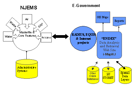
Figure 1: NJDEP IT Framework.
Among the fundamental data elements in the Site Masterfile are the x and y coordinate location and coordinate
system fields. The majority of the site coordinates were collected using GPS and were stored in the New Jersey
state plane coordinate system. A much smaller number of sites had coordinate values obtained by the individual
NJDEP permitting programs and were stored in UTM and other coordinate systems. One of the important tasks
in the i-MapNJ application would be how to deal with site locations stored in different coordinate systems and in
different units coming from the same source table in Oracle.
3.3 ENDEX
In 1997, staff in NJDEP's BGIA began developing the Environmental Data Exchange (ENDEX) web site. The goal of ENDEX was to provide
both NJDEP staff and the general public a means to access and share environmental information. The concept has since been broadened
beyond environmental data and has evolved into the NJ Spatial Data Clearinghouse. The BGIA and Rutgers University developed the NJ
Environmental Digital Library (NJEDL). The NJEDL is an online repository of environmental literature and multimedia related to New Jersey.
The repository includes documents and reports, scientific studies, photographs, videos and maps. In addition to registering spatial data and
making GIS data available, BGIA plans to manage the production of interactive mapping applications, such as i-MapNJ, and make them
accessible through ENDEX and the NJ Spatial Data Clearinghouse sites.
3.4 ArcSDE
In early 2000, staff in NJDEP's BGIA attended ArcSDE training to understand the benefits of using GIS data in the ArcSDE format,
learn how to load existing GIS data layers into the ArcSDE format, and become familiar with ArcSDE requirements. BGIA is
implementing ArcSDE in order to support its future enterprise GIS strategy within the agency. The i-MapNJ application would require
GIS layers in ArcSDE format. NJDEP identified the data layers critical to the i-MapNJ application and BGIA prepared them for ArcSDE.
In some cases, the layers that were in county tiles had to be appended to into a state-wide layer. Since ArcSDE demands error-free
topology, in a few cases some layer editing was performed. After some investigation, it was decided that serving the digital orthophoto
images from an image directory would be a better solution for NJDEP than storing images in ArcSDE.
back to top
4. i-MapNJ Design Decisions
In early 2000, BGIA began making plans for using Esri's ArcSDE and ArcIMS to develop i-MapNJ as a prototype
web-browser based application that would provide basic GIS capabilities to the NJEMS application. Working with AMS
in the planning and design phases, BGIA realized that although this would be designed for NJEMS initially, it needed to be
built in such a way that it could later easily accommodate linking to data from additional database systems. Furthermore,
since future plans called for deployment of the application on the Internet, a logical system architecture solution needed to be
developed which would first serve the Intranet, then with minor modifications the Internet. Many issues had to be considered
in the architectural design. Among them:
- Choice of ArcIMS viewer (HTML/Java Standard/Java Custom)
- Server platform (NT/Solaris)
- Choice of Web application environment (Java/Active Server Pages)
- Location of critical data (NJEMS and GIS)
- Software licensing
- Existing NJ Office of Technology standards for serving web applications
- Physical locations and availability/accessibility of servers
- Firewalls
The following section describes some of these issues and the choices taken by NJDEP for the i-MapNJ application.
4.1 ArcIMS Viewer
The ArcIMS software provides developers the choice of using one of several client-side viewers. The choices considered by BGIA
included the HTML based viewer and the two Java based viewers. Since i-MapNJ is eventually going to be both an Intranet and
Internet application, BGIA opted to go with the HTML based viewer. With the HTML viewer, all processing work (map rendering) is
done on the application server and is sent to a client's web browser as an image. This is an advantage the HTML viewer has in an
Internet situation over a Java based viewer, where a map view is reconstructed on the client's end and requires a user to download the
Java Runtime Environment (JRE) and ArcIMS Java viewer components. Both the Java Custom and HTML viewers allow developers to
customize the look and feel of the application. The Java Standard and Custom viewers do provide some additional functions beyond
the capabilities of the HTML viewer. After careful consideration, BGIA felt that the absence of these functions, would not greatly
impact the application's overall purpose.
4.2 Server Platform
The NJDEP purchased two NT server machines, one to run the Web Server and the ArcIMS Application Server, the other to run
the ArcIMS Spatial Server. There was some debate between going with the Solaris or NT operating systems. Up until this time,
NJDEP's GIS servers (administered by BGIA) had traditionally run using the Solaris operating system. For this project however, BGIA
opted to go with servers running NT for several reasons. First, since there was a fairly short deadline to get the first phase completed,
NJDEP needed to purchase the servers in a relatively short amount of time. NT servers are typically less expensive, and therefore the
justification process is less onerous. While a Solaris solution would have been the more traditional choice for NJDEP's GIS, given the
cost and justification process, it would have been difficult to meet the deadline. In addition, the New Jersey Office of Information and
Technology's (NJOIT) Office of GIS had success developing their ArcIMS site using NT servers.
4.3 Web Application Environment
The i-MapNJ application would be making database calls to Oracle tables (NJEMS and GIS ArcSDE). An
application environment would be needed to make these calls, and the options NJDEP considered were Java and
Active Server Pages (ASP). NJDEP opted to go with ASP for several reasons. The Java option would have required
the use of a separate application server that would have unnecessary added cost and would have meant that BGIA
might have had difficulty administering the application server. Currently all NJDEP e-government application servers
are managed and maintained by administrators from the NJOIT. The BGIA staff has traditionally administered their
own servers and wanted to continue to be self-reliant. The ASP option was favored as a less expensive option that
would allow BGIA to maintain the servers, easily allow for testing application performance for both Intranet and later
Internet through firewalls, and had been piloted by NJOIT's Office of GIS.
4.4 Location of Critical Data
The NJEMS Oracle tables currently reside on servers maintained by NJDEP Office of Information Resources Management (OIRM)
staff. The GIS data, in ArcSDE format, resides on NJDEP's GIS server maintained by BGIA staff. Considerations were made for
minimizing Oracle instances (requiring separate ArcSDE licenses) where possible. There were several solutions NJDEP considered
as to where the data would reside for this application. There were Oracle/ArcSDE compatibility issues as well. NJEMS data were
being maintained on the OIRM NJEMS server running Oracle 7.3.3, whereas the GIS ArcSDE data layers were being maintained on the
GIS server running Oracle 8.1.5 and ArcSDE 8.02. The solution preferred by NJDEP was to copy the NJEMS Sites table that was
created specifically for the i-MapNJ application to the GIS server. This table contains basic site information including site ID, name,
address, and coordinate data. The table could then be spatially enabled using ArcSDE and could link to other NJEMS tables on the
NJEMS server using the site IDs found in the Sites table and in NJEMS tables. Database links established between the Sites table on
the GIS server and NJEMS tables on the NJEMS server would enable access to the critical site environmental data. Since the sites'
information in NJEMS are dynamic, updates to the Sites table are fed from NJEMS using a site loader routine developed by AMS.
NJDEP plans to establish similar links to databases such as NJ STORET in development efforts scheduled for summer and fall, 2001.
back to top
5. i-MapNJ System Architecture
Since NJDEP plans to eventually make the i-MapNJ application available, in some form, to outside users as an Internet
application, the system's architecture had to be designed to easily accommodate the porting of the application outside of
NJDEP's firewall. The current architecture design serves the i-MapNJ application only on NJDEP's Intranet. With some
minor changes to the architecture, the application will be able to run as an Internet application. The New Jersey Office of
Information and Technology is working with NJDEP's BGIA to build the necessary infrastructure to support the i-MapNJ
as an Internet application.
There are five basic tiers that make up the current i-MapNJ architecture. The tiers do not necessarily correspond to machines, but to places
where specific system processes are carried out. Included is the client or user's PC (Tier 1), the Web Server (Tier 2), the Web Application
Server (Tier 3), the ArcIMS Application Server and ArcIMS Spatial Server (Tier 4), and the data storage tier including both the NJEMS Database and the GIS
Database servers (Tier 5).
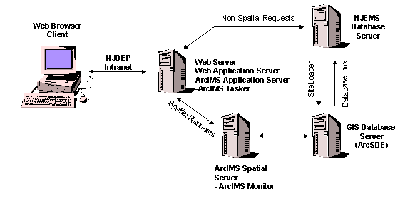
Figure 2: i-MapNJ Architecture.
5.1 Tier I - Client
Microsoft Internet Explorer and Netscape web browsers are the standard web browsers used by staff in NJDEP. The
ArcIMS HTML viewer was chosen since it is customizable and has the least restrictive hardware requirements. The
HTML viewer has some advantages over the ArcIMS Java viewers that will come into play when the application
comes to the Internet. The Java Standard viewer is not customizable. The Java Custom viewer has some advantages
over the HTML viewer, but is best suited for Intranet applications. Both Java based viewers require more processing
work to be done on the client's end. The Java viewers also require a (one time) download of the Java Runtime
Environment (JRE) and ArcIMS Java viewer components. It was perceived that there could be some serious
performance hits taken on the client's side when the application reached the Internet if NJDEP chose to develop
i-MapNJ using the Java Custom viewer. In addition, at the time NJDEP reached its decision on which viewer was
going to be used, Netscape browsers did not support Java 2 applets used by the Java Custom viewer. Since AMS
was going to use JavaScript for some NJDEP required customization of the HTML viewer, it was understood that
staff using older versions of these browsers would have to update them in order for i-MapNJ to fully function properly.
5.2 Tier II - Web Server
The NJDEP ArcIMS Web Server is located inside NJDEP's firewall on NJDEP's Intranet. The web server software is Microsoft
Internet Information Server (v.4.0), running on the Windows NT 4.0 Server operating system. The Web Server communicates with
the Web Application Server for non-spatial data queries (involving NJEMS data) and the ArcIMS Application Server for spatial
queries (involving GIS layer data). The communication between the Web Server and the ArcIMS Application Server is accomplished
via a Java servlet engine.
5.3 Tier III - Web Application Server
The Web Application Server is responsible for handling the non-spatial data retrievals of NJEMS data from the NJEMS database
server. The Web Application Server is running Microsoft Transaction Server 2.0 and is located on the same NT machine as the
Web Server and the ArcIMS Application Server.
5.4 Tier IV - ArcIMS Application Server
The ArcIMS Application Server runs as an NT service on the same machine as the Web Server and Web
Application Server and handles incoming requests from the Web Server. The ArcIMS Application Server uses a Java
servlet engine (ServletExec v3.0) as a connector to provide the communication link between the Web Server and the
ArcIMS Application Server. All spatial queries involving GIS layers and data are passed by the Web Server to the
ArcIMS Application Server, using the servlet connector.
5.5 Tier IV - ArcIMS Spatial Server
NJDEP has one ArcIMS Spatial Server running on a separate NT machine from the Web Server and ArcIMS
Application Server. The ArcIMS Monitor NT service is running on this machine, tracking the state of the ArcIMS
Spatial Server. The Spatial Server enables the access and bundling of maps and data in the appropriate format prior
to the information being sent to the Web Server. The i-MapNJ MapService is a process running on the
ArcIMS Spatial Server which instructs the ArcIMS Spatial Server how to render the map (layers, symbols, etc.)
when a request is received. It is an image map service, which returns a JPEG map image that a user sees when running
i-MapNJ.
5.6 Tier V - NJEMS Database Server
The NJEMS Database Server manages the NJEMS data. The NJEMS data tables includes core site data
(IDs, coordinates) and business data (agency activity, discharged parameters, program interests, permit violations,
etc.). Several Oracle data views were created to allow the i-MapNJ application to access NJEMS data more
efficiently. A special SITES view was produced specifically for the i-MapNJ application that contains NJEMS ID,
site name, address, coordinate, and coordinate system for each site record. The NJEMS data is not spatially enabled
with ArcSDE on the NJEMS Database Server.
5.7 Tier V - GIS Database Server
The GIS Database Server manages the ArcSDE GIS data layers. Over twenty GIS layers were reproduced in
ArcSDE format and included in the i-MapNJ application. For more information on the layers included, see Appendix
C. The SITES layer is special since it is produced and updated from the SITES view on the NJEMS database server
every fifteen minutes using a site loader program developed by AMS. On the GIS database server the SITES table
is spatially enabled using ArcSDE.
back to top
6. i-MapNJ Application Production
Work on the i-MapNJ application began in July 2000. AMS worked closely with BGIA staff to develop a work proposal that would attempt
to achieve all of the functionality in NJDEP's vision for the application. Since AMS had developed NJEMS for NJDEP, AMS had great
familiarity with the locations of critical data elements that would be used in the application. BGIA staff had the responsibility of providing
AMS everything necessary to complete the project. This included preparing the GIS layers in ArcSDE format, answering technical questions,
providing feedback, and organizing system testing before final delivery. Working with staff from various NJDEP programs, the fundamental
NJEMS site search types were identified.
6.1 Technical Issues
ArcIMS 3.0 and ArcSDE 8.0 were relatively new products, and the success of the project depended on both
BGIA and AMS acquiring a high level of understanding of these products and their capabilities. Making this more
difficult, NJDEP and AMS were under a tight deadline to complete the application by October. Several of the
functions demanded by BGIA for i-MapNJ needed to be "explored" by both AMS and BGIA to see if they were in
fact possible given the limits of ArcIMS - specifically the HTML viewer. There is very good documentation that
comes with the ArcIMS software. With its open architecture, ArcIMS allows for the development of customized
tools that can extend an application's capabilities even further. With assistance from Esri on several software technical
issues, AMS was able to implement most of the functionality that was to be "explored" by AMS and BGIA for the
i-MapNJ application.
AMS met with NJDEP staff at several stages to provide a glimpse of the application as it was being developed. Much discussion was
held on how to guide users through the search criteria that would allow them to retrieve NJEMS site data. A wizard approach was
settled on that would present only search criteria relevant to the particular search that was being performed. GIS layer symbols were
selected and changed several times in an attempt to eliminate confusion when certain layers were visible at the same time.
6.2 System Testing and Delivery
System testing began in late September 2000. Approximately thirty people from various NJDEP programs
participated in the testing phase. Test scripts were developed beforehand for testers to follow. This was to insure that
all of the application's functions would be tested. Testers included NJDEP staff that came from programs that used the
NJEMS application on a daily basis, most of whom had little exposure to viewing familiar sites in a GIS environment.
Testers also included a good number of people who worked regularly with ArcView or ArcInfo GIS. The testing
phase afforded the opportunity to work out bugs, and elicit comments from the testers. Many suggested minor
enhancements were added, while others were logged for future enhancement consideration.
Testing was completed and the final i-MapNJ software build was delivered to NJDEP in the middle of October. Since the application
was built to run against a development version of NJEMS initially for testing purposes, AMS assisted BGIA in transitioning i-MapNJ
to the production version of NJEMS in January 2001.
back to top
7. i-MapNJ General Workflow and Components
7.1 Launching the Application
The i-MapNJ application can be accessed in two ways. The application can be launched by users while working
within the NJEMS application by clicking on the GIS tool on the NJEMS main toolbar or selecting the "GIS" menu
item under the NJEMS application's Tools menu option.
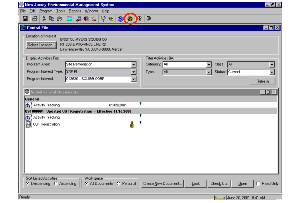
Figure 3: Launching i-MapNJ from NJEMS Using i-MapNJ Tool.
The application can also be launched by users from the NJDEP's Environmental Data Exchange (ENDEX) Intranet
site. In either instance, the user's default web browser is opened, and the application is launched. Users launching the
application from NJEMS already have an NJEMS site of interest (based on the site the user currently has selected
within NJEMS) and are presented with a map view of the site, at a view extent of 1 mile wide. Visible in the map
view is the site's location with a unique symbol along with an aerial orthophoto image. Users can then click on the
Find Sites button to perform a multi-site search and/or click on the Layers button to add GIS data to the view.
Users launching the application from the ENDEX Intranet site are also taken to the i-MapNJ viewer, but since there
is not an initial NJEMS site of interest, the application instead displays a map of the state of New Jersey. Users can
then click on the Find Site button to search for an NJEMS site by ID, locate an address (NJEMS site or not), or
locate an X-Y coordinate (in NJ State Plane coordinates). Alternatively, users may attempt a multi-site search by
clicking the Find Sites button at the bottom of application's window. They may also click on the Layers button to
add GIS data layers to the view.
7.2 Application Navigation
Users can easily navigate through the application's screens and pop-up windows. The i-MapNJ application is
made up of several visual elements. The map viewer frame contains the map view that renders the map graphics that
include GIS data layers, scale bar, and north arrow.
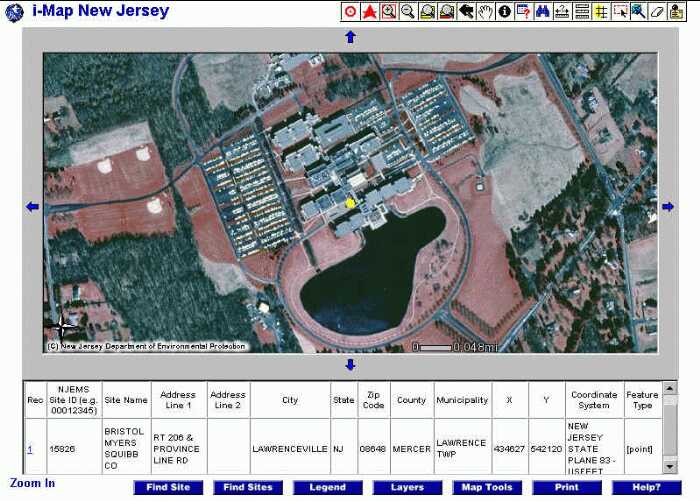
Figure 4: i-MapNJ Application Screen.
The application's map window enables users to display search results along with additional GIS data. GIS data are
drawn using symbols that are predefined by the developer in the i-MapNJ MapService's AXL file. Various GIS
data layers can be made visible by the user by checking a layer's checkbox in the map layers window. Certain GIS
data layers have scale dependencies, which prevent them from appearing at small map scales. Layer scale
dependencies are set by the developer in the MapService's AXL file.
The tabular data frame displays data from NJEMS retrieved from the NJEMS searches or data associated with
features from an active GIS layer that have been selected.
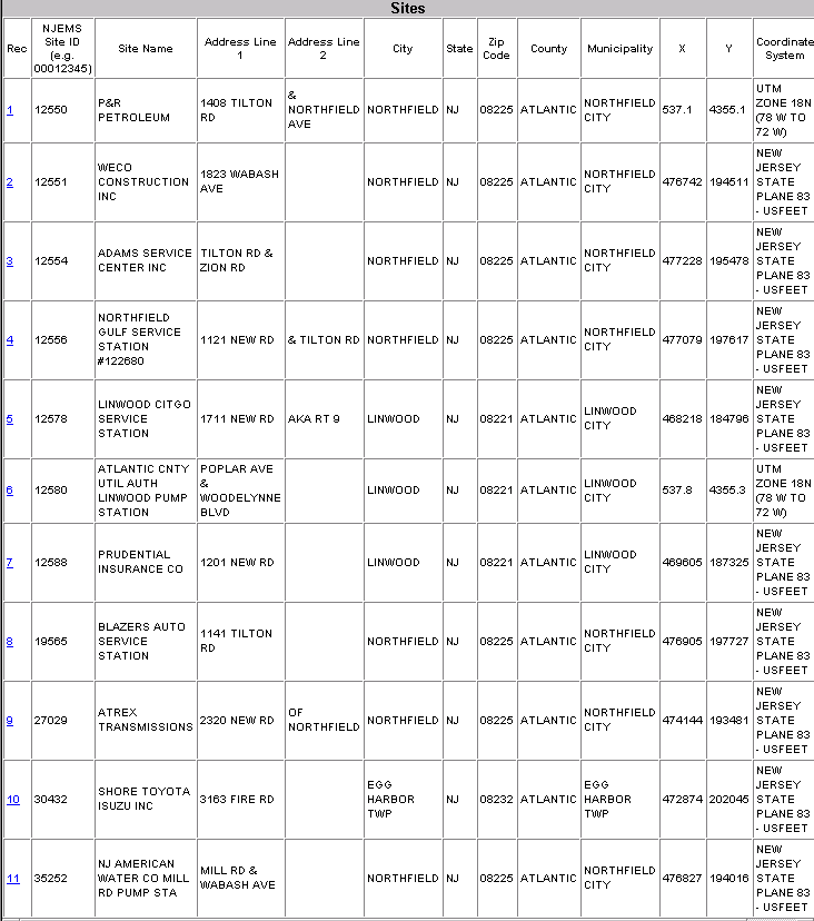
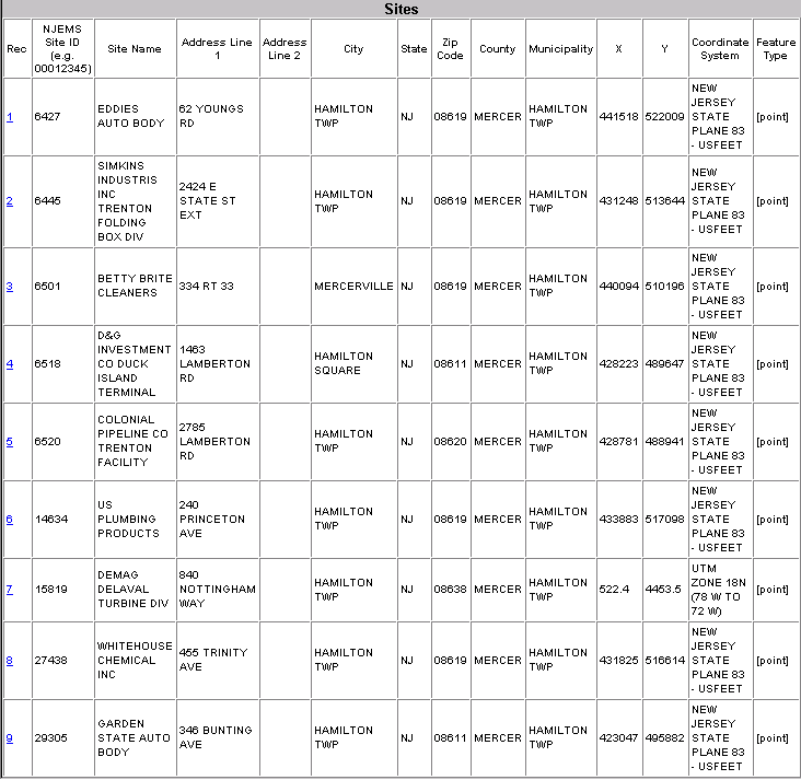
The tabular data retrieved from NJEMS searches include Rec (record number), NJEMS Site ID, Site Name, Street
Address Line 1, Street Address Line 2, City, State, Zip Code, County, Municipality, X-Coordinate (Easting),
Y-Coordinate (Northing) and Coordinate System. The tabular data related to features from an active GIS data layer
are specific for each GIS layer.
The i-MapNJ application's main toolbar allows users to activate the application's major functions including site
searches, the display of a map legend, the display of GIS layers, the enabling of a map toolbar, map printing, and
application help. The main toolbar's functions are further defined in Appendix A.
7.3 GIS Data Layers
When users click on the Layers button, a new window opens listing the currently available GIS layers for display.
GIS data may be made visible by clicking in the checkbox next to the layer's name, then clicking on the Refresh Map
button. Many layers can be made visible at the same time. Refer to Appendix C for a list of GIS data layers included
in the application.
Only a single layer can be designated as the active layer. By making a layer active, the user then can perform actions
using map tools (Identify, Query, Buffer, Select by.) on that layer.
7.4 Map Tools
When users click on the Map Tools button, the Map Toolbar appears. Users needing to perform some basic GIS
analysis find these tools useful. Most of these are default tools provided by the ArcIMS HTML viewer out of the box.
Several where created as custom tools by AMS. For detailed descriptions of tool functionality, refer to Appendix B.
7.5 Print
When users click on the Print button, i-MapNJ provides a Print Map frame. The user may enter a custom title for a
map, and the frame provides a Create Print Page button that when clicked on produces a print page of the map
graphics (including title and legend) which can be sent to the user's printer.
7.6 Help
The Help button provides answers to frequently asked questions and help related to the main toolbar and map
tools functions.
back to top
8. NJEMS Site Searches
The search types within the i-MapNJ application are designed to retrieve either a single site or multiple sites from NJEMS. The single site
queries provide for locating an NJEMS site (or any location of interest) by entering an NJEMS Site ID or a Program Interest Facility ID, locating
a site by address, or locating a New Jersey State Plane Coordinates (NAD 83 datum, survey feet units). The multiple site queries allow users to
retrieve sites having one or more NJDEP program interests, sites based on NJDEP agency activity criteria, permit violations criteria, or
discharged parameter criteria. The multiple site queries also allow the user to limit the retrieved set of sites to a specific geographic area. The
geographic area can be a radial range where the user specifies a radius distance from a designated NJEMS site (or any location of interest), or
the area can be defined by a GIS polygon that represents a county, municipality, or watershed.
8.1 Single Site Searches
Single site searches can be performed using NJEMS Site IDs, street address, or NJ State Plane Coordinates. For an example, see
Appendix D.
8.1.1 NJEMS Site and Program Interest IDs Search (NJEMS ID)
If a user wants to search for a specific NJEMS ID, they may enter either the NJEMS Site ID or Program Facility ID (Preferred ID
Number) in the NJEMS ID textbox. If the Site ID box is checked, all NJEMS site records will be checked for a match on Site ID. If the
Program Facility ID box is checked, only NJEMS site records belonging to the designated Program Interest will be searched (faster!).
If the ID is found, the application presents the map view with the NJEMS site associated with the ID uniquely symbolized. If the ID
is not found, the application will indicate that the ID does not exist and that no sites were found within NJEMS.
8.1.2 Address Search
A user may alternatively attempt to search for an NJEMS site by entering a street address. The application provides a window
with address fields in which the user may enter an address. The application normalizes the address (i.e. uppercase the address and
replace address names with U.S. Postal abbreviations) and searches for the address against known NJEMS Sites. If found, the
application presents the map view, zoomed to the site's coordinate (value stored in NJEMS), with the site uniquely symbolized, along
with some basic NJEMS data describing the site in the tabular data view. If there is no matching address in NJEMS, the application is
designed to attempt to estimate the location using the ArcIMS address matching function. In this situation, the address ranges that
are coded to the road segments that make up the TIGER roads GIS layer are used as the basis to estimate the location of the entered
address.
8.1.3 New Jersey State Plane Coordinate Search (X-Y Coordinate)
Users may alternatively search for a location by entering an X-Y coordinate pair in the New Jersey State Plane Coordinate
System (NJSPCS), in US Survey Feet units, referenced to the NAD 83 horizontal geodetic datum. The application will render the map
with the X-Y point centered in the map viewer with a view width extent of 1 mile.
8.2 Multi-Site Searches
As mentioned previously, the multi-site searches available through this application allow the user to retrieve multiple
sites that meet selection criteria specific to the type of search. The multi-site searches allow retrievals based on agency
activity , discharged parameter, program interest, and violation. These retrievals can be constrained to sites within a
specific distance (radial search) of an NJEMS site or other point of origin, or to sites which fall within a specific
municipality, county or watershed. For examples, see Appendix D.
8.2.1 Establishing a Point of Origin for a Radial Search
In order for a user to perform a radial search for NJEMS sites, a point of origin must first be established. This will
most often be the location of an NJEMS site of particular interest, but could also be any address or New Jersey State
Plane Coordinate. The point of origin can be the coordinate of an NJEMS site passed to the application from NJEMS,
or the location established during a previous single site search. A point of origin can also be established using the Set
Point of Origin tool from the Map Tools toolbar. With an established origin point and a radius distance (in miles)
entered by the user, the application can determine which NJEMS sites meeting the entered selection criteria fall within
the defined buffer.
8.2.2 Designating a GIS Polygon for a Spatial Search
In addition to performing a radius search about some established point of origin to retrieve a subset of
NJEMS sites, a user may instead designate a specific polygon from one of three GIS layers that are available
to spatially constrain the NJEMS retrieval. The GIS layers from which specific polygons can be selected
include New Jersey counties, municipalities, and watersheds. With this designated polygon selected by the
user (example: Atlantic County), the application can determine which NJEMS sites meeting the entered
selection criteria fall within the GIS polygon.
back to top
9. Future i-MapNJ Enhancements
The completion of the i-MapNJ application's first phase was a milestone for NJDEP. As programs from around the
department witnessed the power of linking NJEMS and GIS using ArcIMS and ArcSDE, many new ideas emerged. For
many working with the NJEMS application, a great need is to enable i-MapNJ to "drill down" to data elements below the
existing site-level elements currently available. NJEMS enables users to view data on the "subject item" level. Subject items
include wells, intakes, discharge points, emission stacks, etc.). NJDEP still needs to collect good location coordinates for
many of these features.
The first phase demonstrated that NJDEP could build an ArcIMS application integrating agency activity, permitting and
enforcement data from the NJEMS DBMS. The next logical step on the data side would be to integrate additional sources of
environmental data. The NJ STORET water quality database is one of the most likely candidates since it currently resides on a
server at NJDEP in an Oracle based DBMS. Having the NJ STORET data would greatly add to the application's value as an
NJDEP analysis tool. i-MapNJ could begin to show how permitting and agency activities are impacting the water quality in a
given area. One of the issues that will have to be dealt with is how parameter data is treated when coming from multiple data
sources. Parameter data will not always be reported in a consistent fashion, and it will be crucial to develop a system whereby
like parameters known by different names, formulas, or codes are matched in an appropriate fashion.
Many users suggested additional GIS data layers should be added to the application. Though this is probably among the
easiest enhancements to carryout, it can be difficult with many layers to assign map symbols that will be clear and distinct.
The capability to easily export tabular data or generate customized reports and maps are other enhancement features high on
NJDEP's list. With NJDEP's use of the HTML viewer, exporting of tabular data for use with an external desktop application
is not a simple process. Users want to be able to take the tabular results and export the data to a spreadsheet or table that
they can then use for further analysis, perhaps in a sophisticated model.
back to top
Acknowledgements
The development of the i-MapNJ ArcIMS application required the vision, support, and feedback from many individuals within
the New Jersey Department of Environmental Protection. Special thanks to:
Irene Kropp
Larry Thornton
Andy Hendrickson
John Fleming
Patrick Meola
Thanks also to the many NJDEP staff, including the NJEMS Core Team members, that provided comments and feedback at
different stages of development and during testing.
The authors wish to thank all at American Management Systems that participated in the i-MapNJ application project's
management, planning, and development. Special thanks to:
Jeffrey Adams (Project Manager)
Matthew White
Sarah Campen
Marie Chenu
Clay Goldwein
Gary Singer
The authors would also like to thank the following Esri staff for their support at various stages of the project:
Archie Minix
Deepti Dev
Frank Xia
Vince Angelo
Chris Cappelli
Dave Wrazien
Peter Bottenberg
All of your efforts have helped make i-MapNJ a great success.
back to top
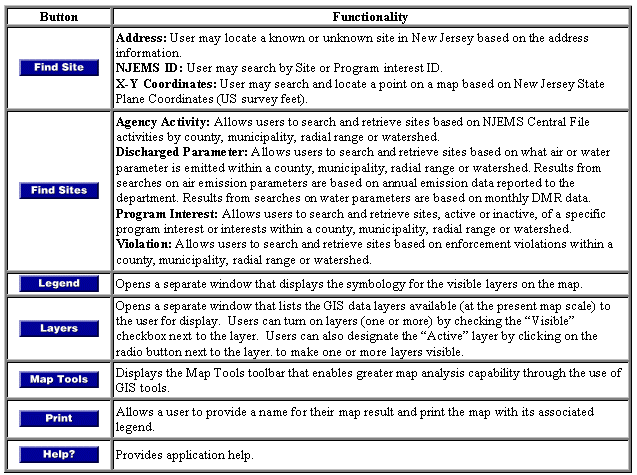
Appendix A - i-MapNJ Main Toolbar Functions
The following table summarizes the function of each tool:
Table A-1: i-MapNJ Main Toolbar Functions
back to top
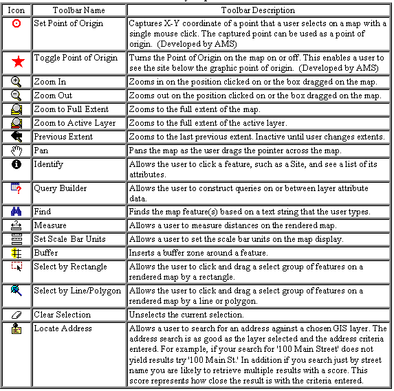
Appendix B - i-MapNJ Map Tools Functions
The following table summarizes the function of each tool:
Table B-1: i-MapNJ Map Tools Functions
back to top
Appendix C - GIS Layers Used in the i-MapNJ Application
The entire list of GIS layers available in the application includes:
CAFRA Boundary
Congressional Districts
Counties
Known Contaminated Sites
Land Use (1995)
Legislative Districts
Municipalities
NJ State Boundary
Orthophotography (1995/97)
Pinelands Management Area
Public Community Water Supply Wells
Quarter Quads
Roads (source NJDOT)
Roads (source TIGER)
Sites (NJEMS)
Soils
State Planning Areas
Streams
Surface Water Intakes
Water Bodies
Watershed Management Areas
Zip Codes
back to top
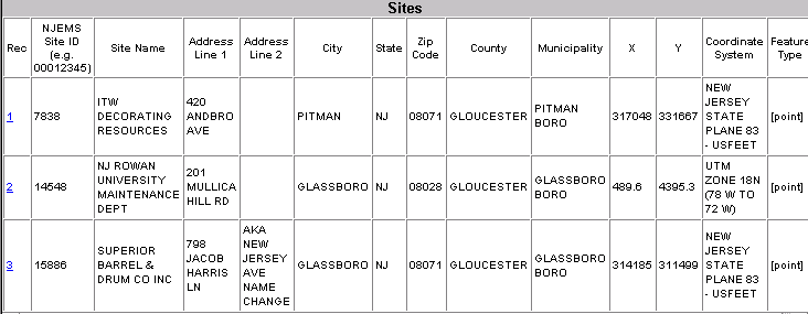
Appendix D - Site Search Examples
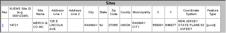
The following is an example of single site search from the i-MapNJ application. The yellow
circle symbol represents the location of the site from the search. In this
example, a unique NJEMS site ID was used to search for the site, producing the following map and tabular
data displays.
Single Site Search (with NJEMS site ID)
NJEMS ID: 14721
Figure D-1: Single Site Search Map View
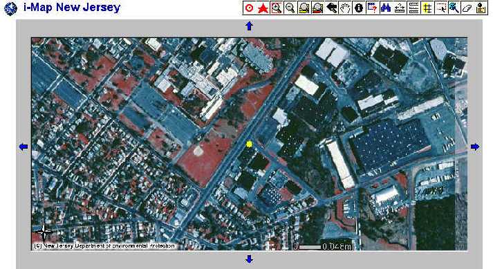
Table D-1: Single Site Search Results Table
back to top
The following are some examples of NJEMS multi-site searches from the i-MapNJ application. Each example lists the search
parameters entered to produce the respective map and tabular data displays. The red stars in the examples represent the
origin point for a radial search. The yellow circles represent the locations of NJEMS sites that met the search criteria, and
correspond to the site records listed in the tabular data display. The black polygon outlines on the maps are county
boundaries, red dashed lines are municipal boundaries, and the dark pink shaded polygons represent the spatial GIS polygon
that was designated in the search.
Agency Activity Search (with search radius)
Program Type: Air
Program Interest Status: Active
Spatial Search Type: Radial Range
Range (miles): 10
Activity Class: Air Enforcement Action
Time Period From: January 1, 2000
Time Period To: December 31, 2000
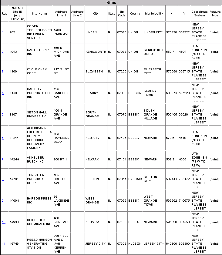
Figure D-2: Agency Activity - Radial Search Map View
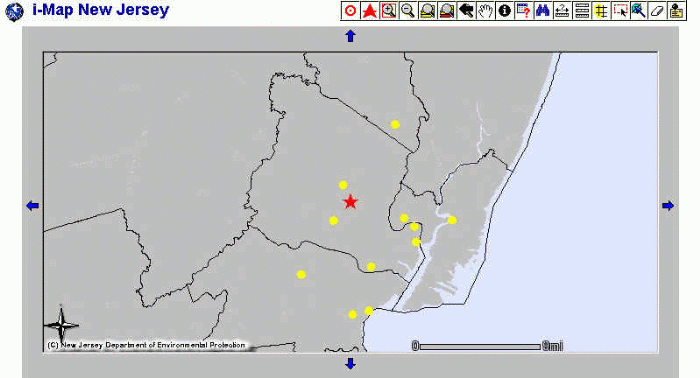
Table D-2: Agency Activity - Radial Search Results Table
back to top
Agency Activity Search (with GIS polygon)
Program Type: Water Quality
Program Interest Status: Active
Spatial Search Type: Watershed
Watershed: North and South Branch Raritan
Activity Class: Discharge to Surface Water
Time Period From: January 1, 2000
Time Period To: June 30, 2000
Activity Type: Surface Water Renewal Permit Action
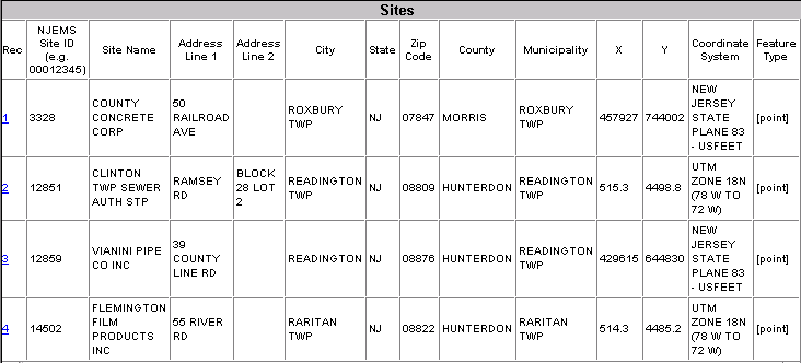
Figure D-3: Agency Activity - GIS Polygon Search Map View
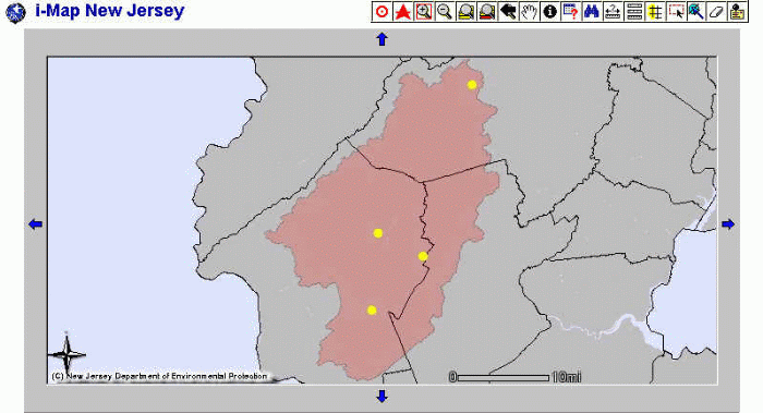
Table D-3: Agency Activity - GIS Polygon Search Results Table
back to top
Discharged Parameter Search (with search radius)
Program Type: Air
Program Interest Status: Active
Spatial Search Type: Radial Range
Range (miles): 5
Regulated Parameter: VOC(total)
Time Period From: 1999
Time Period To: 2000
Figure D-4: Discharged Parameter - Radial Search Map View
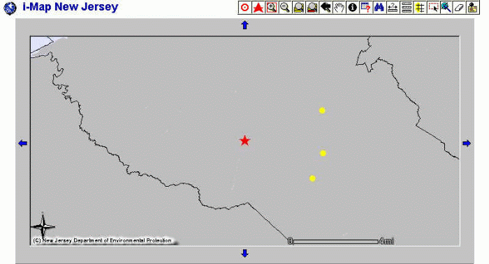
Table D-4: Discharged Parameter - Radial Search Results Table
back to top
Discharged Parameter Search (with GIS polygon)
Program Type: Water Quality
Program Interest Status: Active
Spatial Search Type: Watershed
Watershed: Assiscunk, Crosswicks, and Doctors
Regulated Parameter: Solids, Total Dissolved
Time Period From: December 1, 2000
Time Period To: December 31, 2000
Figure D-5: Discharged Parameter - GIS Polygon Search Map View
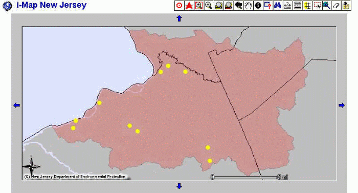
Table D-5: Discharged Parameter - GIS Polygon Search Results Table
back to top
Program Interest Search (with search radius)
Program Type: Site Remediation
Program Interest Status: Active
Spatial Search Type: Radial Range
Range (miles): 5
Figure D-6: Program Interest - Radial Search Map View
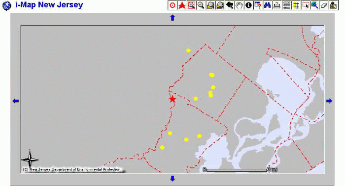
Table D-6: Program Interest - Radial Search Results Table
back to top
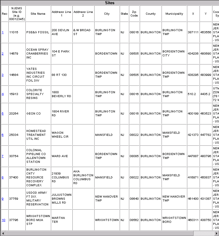
Program Interest Search (with GIS polygon)
Program Type: Hazardous Waste
Program Interest Status: Active
Spatial Search Type: Municipality
Municipality: Hamilton Township, Mercer (County)
Figure D-7: Program Interest - GIS Polygon Search Map View
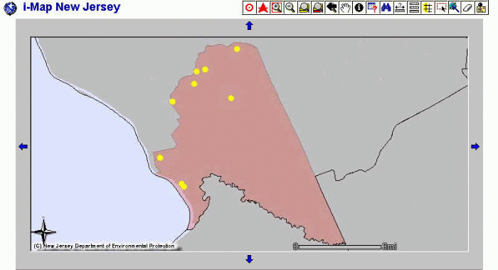
Table D-7: Program Interest - GIS Polygon Search Results Table
back to top
Violations Search (with GIS polygon)
Program Type: Water Quality
Program Interest Status: Active
Spatial Search Type: Watershed
Watershed: Upper Passaic, Whippany, and Rockaway
Time Period From: January 1, 2000
Time Period To: December 31, 2000
Violation Status: Pending
Violation Type: Numeric Viol Max Conc
General Rule: All
Figure D-8: Violations - GIS Polygon Search Map View
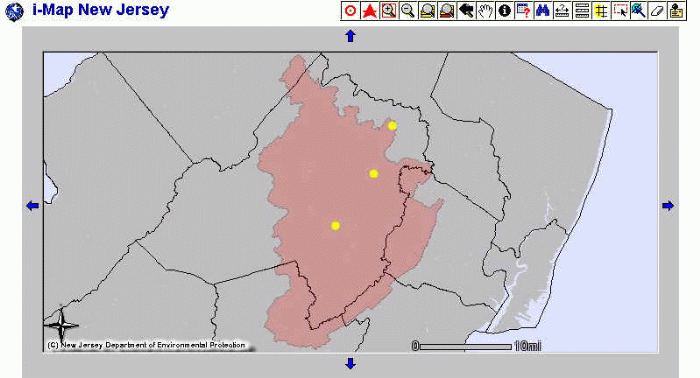
Table D-8: Violations - GIS Polygon Search Results Table
back to top
Authors Information
Lou Jacoby
GIS Specialist I
New Jersey Department of Environmental Protection
Bureau of Geographic Information and Analysis
PO Box 428
Trenton, NJ 08625-0428
(609) 984-2243
cjacoby@dep.state.nj.us
John Fleming
GIS Specialist I
New Jersey Department of Environmental Protection
Bureau of Geographic Information and Analysis
PO Box 428
Trenton, NJ 08625-0428
(609) 984-2243
jfleming@dep.state.nj.us
Larry Thornton
GIS Manager
New Jersey Department of Environmental Protection
Bureau of Geographic Information and Analysis
PO Box 428
Trenton, NJ, 08625-0428
(609) 984-2243
lthornton@dep.state.nj.us
Andrew C. Hendrickson
GIS Specialist II
New Jersey Department of Environmental Protection
Bureau of Geographic Information and Analysis
(Currently:)
Spatial Database Administrator
Verizon Wireless
180 Washington Valley Road
Bedminster, NJ 07921
(908) 306-7338
andrew.hendrickson@verizonwireless.com
back to top