Linda Beale, Hugh Matthews, Phil Picton, Ken Field

Linda Beale, Hugh Matthews, Phil Picton, Ken Field
The project aims to develop, test and apply a GIS system for modelling access for wheelchair users in urban areas. It will work as a decision support and mapping tool for urban planners, and as a guidance device to help wheelchair users assess and select optimal routes through the urban environment. The study employs social science techniques to investigate and quantify urban barriers, and computer technologies to translate these into an operational route assessment and modelling package, using dynamic segmentation and network analysis techniques. This tool is to be applied and tested in Northampton, U.K.
Project Aims
The project aims to develop, test and apply a GIS-based system for modelling access for wheelchair users in urban areas, both as a decision support and mapping tool for planners, and as a guidance device to help wheelchair users to assess and select optimal routes through the urban environment. Accordingly, the system has been designed to:
Access and mobility are important dimensions of quality of life. For wheelchair users, everyday trips are often fraught with problems (Centre for the Environment for the Handicapped, 1986a, 1986b; Imrie, 1996; Matthews and Vujakovic, 1995a) with many barriers, imperceptible to the able-bodied, hindering or totally restricting mobility (Palfreyman, 1991). For example, long inclines without a resting place, high kerbs or uneven surfaces may prove to be insurmountable barriers. Some of these problems can be anticipated or avoided if wheelchair users have good information about access and mobility options. There is a need for an information system that is sensitive to the disparate requirements of an individual user and is based firmly on the perceptions and experiences of the disabled themselves. Furthermore, such a system should be readily updateable so as to incorporate the often temporary but, nonetheless, severe changes that occur in the urban landscape. With traditional paper-based maps and information sources, these requirements are not easy to meet. Using a Geographical Information System, however, it is feasible to capture and integrate the relevant information at a high level of spatial resolution, to model either individual routes or access surfaces using multi-criteria assessment (MCA) techniques and to present the results in an easy-to-understand map form. Within this framework, network analysis tools provide the capability for interactive route modelling.
Method
The study has employed and integrated two contrasting methodological approaches: social science techniques for investigation and quantification of the factors which need to be considered in modelling access to the urban environment by wheelchair users; and GIS to translate these into an operational route assessment and modelling package.
In order to define the factors that actually determine access and mobility for wheelchair users, four hundred wheelchair users were contacted from across Northamptonshire, a county in the East Midlands of the U.K., and invited to complete a postal questionnaire. To further explore the emergent issues a number of focus groups were convened and wheelchair users were taken into an urban environment for on-site observations. Aggregation of these results provided an overview of the features that most impede and, therefore, require inclusion within the GIS database.
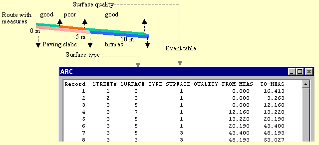
Pavement centrelines provide the basis for the linear route system, with each identified barrier type being linked to this coverage. For the purposes of this research a pavement network was used as a cover to form a network layer of all possible routes around the town centre. This network coverage was derived using Ordnance Survey Land-Line data which is an enhanced vector data set, where features are represented as points and lines that are digitised and specifically coded to show 37 layers including detail and text. A number of issues arise when attempting to demarcate pavements as a range of different features defines pavement edges (e.g. building outlines, walls, road edges). In order to provide consistency, pavement centrelines were manually extracted using the Ordnance Survey Land-Line data as a backdrop. This removed the need to alter the original data whilst, allowing the designer to use local knowledge to derive a network that best represented the general flow of pedestrians around the town centre.
Figure 1. Identified urban barriers to wheelchair access
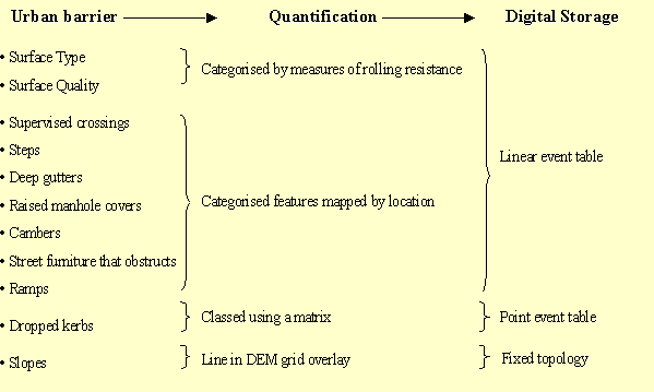
Barriers that are prohibitive or which hinder wheelchair access, such as surface type, quality, camber and slope, are found at different locations along a pavement, with the start and end points rarely coinciding. Linking these features to a linear network necessitates splitting them into a great number of arc segments. Furthermore, this arc coverage would require segmentation should the pavement features alter over time. Using dynamic segmentationä , however, allows all attributes to be stored separately within event tables (INFO files), so that attribute data are separate from the arc node topology. Attributes are associated with the line coverage, and are independent of the beginning and ending of arcs, therefore, any attribute can be updated without modifying the underlying co-ordinate data. All events are linked to routes using linear measures along these routes (coded in the section table).
Figure 2. Event tables
All database construction was carried out using ARC/INFO to benefit from increased functionality. The direction of the route is significant as a number of attributes are direction dependent (e.g. slopes). Arcs were orientated following a pre-determined rule base that distinguished between the two sides of the street. Route barriers were determined along pavements on both sides of a street following the arc direction. Assigning routes by street names allows for ease of data collection and any subsequent update of this attribute data.
Linear features, such as surface type and quality were measured along each road by using field surveys techniques. To quantify the difficulty in travelling over various surfaces the resistance that each surface exerts was measured using a spring balance. Drop kerbs, showing sections where a road may be crossed, were classed using a matrix. These point features were collected in the field using ArcPad. The drop kerbs were then stored as turntable data, thereby allowing the direction of traverse to be significant.
Slope within the urban area was a key feature for wheelchair access. Using a 10m resolution of the study area the slope values were derived using SLOPE function, again within ARC/INFO. The directionality of the route is significant to the slope, with a rising gradient causing greater problems to wheelchair mobility. An AML was, therefore, constructed that assigns a slope value to each arc, within the overlaid arc cover, based on relative positions of the x, y co-ordinates of the FNODE and TNODE. This allows slope value to be added only if the arc direction follows the general direction of slope.
The System
A goal for the user interface was to create a simple, straightforward structure that could be used by inexperienced users, and would be sensitive to the mobility needs of each user. The MAGUS interface was created using Avenue and Dialog Designer to lead the user through the steps required to determine wheelchair accessible routes. A main menu is visible throughout use of the system. All the scripts for the interface are contained within the project and upon initiating the MAGUS system all the required data are loaded into the main view and the legends are set.
The network analysis extension within ArcView enables the modelling of spatial networks, providing the tools to determine paths through linear network systems. Networks of this sort are ideal as they can be used to represent real-world structures such as roads or paths. The network links are modelled as arcs with the attributes being maintained in a network coverage arc attribute table.
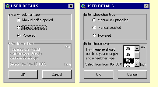
Figure 3. User details
 The accessibility
of each route is determined by the calculation of impedance. Impedance
is the ‘cost’ expressed in terms of barrier weightings, associated with
each street route or turn. Weightings were determined in two ways: 1) the
perceptions of wheelchair users and, 2) direct measurements e.g. rolling
resistance. Any feature upon a route that prevents wheelchair access is
assigned a negative impedance value, thereby prohibiting route determination.
Impedance values are calculated, within the virtual table, based upon user
specifications and selected route option. Among the criteria that are used
to start up the route planning procedure is 'type of wheelchair'.Three
categories of wheelchair are recognised: 1) manual self-propelled 2) manual
assisted 3) powered. Furthermore, each user is required to provide an assessment
of their relative fitness or capacity to travel, employing a weighting
scale of 10 (low level of fitness/poor ability to travel) to 100 (high
level of fitness/good ability to travel).
The accessibility
of each route is determined by the calculation of impedance. Impedance
is the ‘cost’ expressed in terms of barrier weightings, associated with
each street route or turn. Weightings were determined in two ways: 1) the
perceptions of wheelchair users and, 2) direct measurements e.g. rolling
resistance. Any feature upon a route that prevents wheelchair access is
assigned a negative impedance value, thereby prohibiting route determination.
Impedance values are calculated, within the virtual table, based upon user
specifications and selected route option. Among the criteria that are used
to start up the route planning procedure is 'type of wheelchair'.Three
categories of wheelchair are recognised: 1) manual self-propelled 2) manual
assisted 3) powered. Furthermore, each user is required to provide an assessment
of their relative fitness or capacity to travel, employing a weighting
scale of 10 (low level of fitness/poor ability to travel) to 100 (high
level of fitness/good ability to travel).
Two possible methods of route selection have been incorporated:
1) an optimal route based on a' from-to' destination or 2) all wheelchair
accessible routes outwards from a specified location (service network).
Figure 4. Possible route type selection
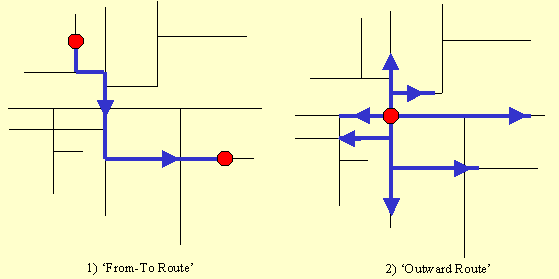
Once the route type is selected the urban area is drawn in the main view and three further dialogs appear to facilitate destination input. A number of other layers from Land-Line data are also automatically drawn in the main view including buildings and street names. Selecting a ‘from-to’ route allows the user to find the best pathway between two locations, or the best route between several locations (A>B; A>B>C etc). The user may specify the point locations, to be visited, by ‘clicking’ at the appropriate points on the pavement line or, by entering the address. A pop-up message box allows the user to select whether these points are to be visited in the order of input or whether they wish the best visiting sequence to be determined. Selecting an ‘outward route’ allows all wheelchair accessible streets within a specified distance, from a point, to be identified.
If a 'from-to route' is selected the user can choose from any combination of a number of route options:
Figure 5. The MAGUS system
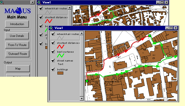
The output routes are automatically displayed on the main menu, where the user can zoom into or out of the routes. Both name and colour differentiate each type of route whilst, direction of travel is shown by arrows. The user may also select to view the barriers that would be encountered upon that route or, display and print directions for the route.
Testing and validation
The qualitative data derived from wheelchair users own experiences have informed the needs of the GIS-based system throughout the initial stages of development. The trial GIS-based route finding model is nearing completion and future work will entail 1) the refinement of the MAGUS system and interface and, 2) the refinement of feature weightings within the system through a rigorous process of testing and validation with wheelchair users. It is anticipated that the system will be made available both within local councils to assist planners and, at designated public information points e.g. libraries - although ideally, it is hoped that the work can be extended in order to develop a transportable system for wheelchair users.
Acknowledgements
This research is supported by the EPSRC (Engineering and Physical Science Research Council) as part of the EQUAL (Extending Quality Life) initiative. The project team is grateful for the support and assistance provided the Northamptonshire Council for Disabled People and Northamptonshire County Council.
References
Centre for the Environment for the Handicapped, 1986a, The external environment and the experiences of disabled people, Centre for the Environment for Handicapped, London.
Centre for the Environment for the Handicapped, 1986b, Pedestrianised Areas, Centre for the Environment for Handicapped, London.
Imrie, R, 1996, Disability and the City, London, Paul Chapman.
Matthews and Vujakovic, 1995a, Private worlds and public places: mapping the environmental values of disabled people, Environment and Planning A, no. 27, pp 1069-1083.
Palfreyman T, 1991, Access and the space that links buildings, Access
by design, no.56, pp 13-16.
Author Information
Linda Beale, Hugh Matthews, Ken Field
The Graduate School
University College Northampton
Boughton Green Road
Northampton NN2 7AH
United Kingdom
Tel. +44-(0)1604-735500
Fax. +44-(0)1604-791114
Phil Picton
School of Technology & Design
University College Northampton
St Georges Avenue
Northampton NN2 6JD
United Kingdom
Tel. +44-(0)1604-735500
Fax. +44-(0)1604-792650