The GIS Department of Houston Community College has written laboratory exercises suitable for the first year of GIS courses. The exercises along with the required data sets are provided on CD-ROM. The exercises, most of which use ArcView, are based upon interviews with our GIS user community. They emphasize problem solving skills for typical workplace GIS. These exercises are available to any instructor who registers with HCCS. Users are asked to pay shipping and handling and to provide feedback upon their use. Included with the student exercise are an instructor's version and an example of the completed product. One sample exercise will be distributed with this talk with others available for examination. This work was supported by National Science Foundation along with efforts of a dozen other GIS instructors from around the country.
For the past three years the authors, along with Sydney Elliott of the Houston Community College System (HCCS) and Dr. Gary Jeffress of Texas A&M University at Corpus Christi (TAMUCC) have written 40 laboratory exercises targeted for two semesters of introductory college-level Geographic Information Science (GIS). The project was supported in part by the National Science Foundation (NSF DUE 9850344) and HCCS. Opinions expressed are those of the authors and not necessarily those of the NSF or HCCS.
The laboratory exercises apply GIS principles and are intended to supply abundant hands-on problem solving of typical workplace applications with data sets commonly used in the workplace. These exercises and the courses are not software tutorials, although approximately 3 weeks of each course is set aside for a software tutorial. We assume that the student has some familiarity with the basic button-pushing operations and the software specific terminology when they begin our exercises. We use the ArcView tutorial by Esri to carry out this first step.
This paper does not address the GIS principles that should be included in an introductory course, but we do note the following especially for those about to initiate a new program in GIS. GIS is such a new area in education that a general consensus of principles and concepts to be taught in an introductory course has yet to emerge. We consulted the following sources in developing our curriculum: 1) The Core Curriculum for Technical Programs project developed by the National Center for Geographic Information Analysis. 2) The introductory college level texts published by Demers, K. C. Clark, and Heywood et al. A workshop on " Core Elements of an Introductory Course in Geographic Information Science (Systems)" held in Houston Texas in February of 2000 developed a series of suggestions for an introductory course published at our web site.
Beginning courses in GIS are presently found from freshman to graduate levels in the College-University sequence. The exercises could be used at any college or university level, as long as it is the beginning course. At many colleges GIS is considered as a sub-topic within a major discipline. Even within a given university GIS may be introduced at the undergraduate level in one department such as Geography, and taught only at the graduate level in another department such as Forestry. A few universities such as Texas A&M at Corpus Christi and many community colleges on the other hand are often treating GIS as a separate discipline, we follow this approach.
We began instruction in GIS 3 years ago. To date most of our students are older than the typical undergraduate and have worked for several to many years. We anticipate that the number of more typical undergraduates (18 to 22 years old) will increase as GIS becomes better known. According to two colleagues the number of typical undergraduates began to increase after their programs had been running for 5 years (Pers. Comm. Q. Lotti, Alexandria Technical College and R. Schubert, Roane State Community College).
Some students are already trained in various disciplines such as Geography, Civil Engineering, Environmental Science, and Marketing. They may come to us as new college graduates from schools lacking GIS programs or with few to many years in the workplace practicing the discipline they were trained for. For them, GIS is a tool to be applied to discipline related problems, and a lower level certificate typically is their goal.
At HCCS we complete about 25 exercises in our first year of GIS/GPS. The current list includes 15 additional exercises so other instructors could pick and choose to suit their situation. Most of the exercises use ArcView 3x or, in the case of some GPS exercises, no GIS software at all. More details about the department, the authors, the NSF project, and the exercises are found on our web site swc2.hccs.cc.tx.us/gis/index.html. As this is written the data sets, totaling several hundred megs, are not available for download.
The exercises were developed and tested through consultations with our advisory board. This group of 20 active GIS users represents a variety of businesses and government agencies. We interviewed them to determine how GIS was used in their business, along with the data required. They also provided appropriate data sets to us or, when the data were confidential, pointed us toward a substitute data set. The exercises are intended to mimic the early experience a new GIS graduate might meet in the workplace. That is the supervisor, who may not know the software well, gives the technician a task and directs them to the necessary data. All of the exercises emphasize problem solving in GIS and are not the GIS tutorials typically found in books or on web sites.
Each exercise is intended to run 1-2 hours, meaning that it can be completed within the class period. The experience and ability of our students varies considerably, ranging from beginners to workplace veterans, no degrees to Ph.D., and computer novices to computer experts. Consequently the individual completions can vary from an hour to as much as 3 hours. Students print their output in 8.5x 11 format rather than larger wall displays. In part this reflects the practical problem of plotter speeds and getting everyone finished on time.
Sixteen college instructors from eight states have attended weeklong workshops on the exercises in the summers of 1999 and 2000. Although some had taught GIS for one or more years, some had never taught GIS and a few had only a rudimentary knowledge of GIS software. These instructors worked through as many of the exercises as possible in the time available. They provided criticisms and ideas that greatly improved the package.
Many of the participants then used various exercises in their own classrooms and continue to provide valuable feedback. We have now used most of the exercises in our introductory classes for the past three years. We estimate that 300-400 students (our students + students of our college partners) have been exposed to and tested the exercises over the past three years.
ne major revision was made after our first workshop. The exercises presented to our partners included only a Student Version. Our college partners recognized that some GIS instructors are themselves beginners and would not be able to work with the Student Version without training. To address that concern we have also included an extensively annotated Instructor Version of the exercises. This version includes various notes on how to complete certain sections as well as an example of a completed map or other graphics for each exercise.
In our classroom we post several examples of student's final results for each exercise from previous semesters. This provides the students with some idea of where they are going and reflects some reality of the workplace; typically a practitioner of GIS must have a clear picture of the final product when starting a project. None of the examples are identical so students see that there are different approaches to the same problem. Each example solution could be improved upon and some have obvious flaws.
Our goal is to produce students who can solve problems when they enter the workplace. We could have written our exercises in a detailed step-by-step tutorial format, but we intentionally provide fewer and fewer explicit directions as students progress through the exercises. Students are increasingly urged to go back to earlier lessons, to ArcView help, to their textbook, and to the web, to find software solutions. We also encourage students to work together to foster teamwork and networking. These are important workplace skills well documented in the study by the Secretary's Commission on Achieving Necessary Skills (SCANS). Our 20 member Advisory Board consisting of employers from both the private and the public sector also endorses this approach. Forcing students to become self-reliant is perhaps one of the most difficult skills an instructor can learn, but in our view our students would in the end be poorly served by the tutorial approach.
The exercise which follows, "Expanding Your Business to Texas", was based on a project carried out by the Houston-Galveston Area Council (H-GAC). This Council of Government is a principal agency in a consortium of other government agencies and private sector members in the Greater Houston Area that have pooled their spatial data sets. H-GAC is mainly taxpayer supported, but also performs contract work for outsiders. A West Coast grocery chain seeking to expand their business to Texas had approached the H-GAC. H-GAC provided several potential locations in part based upon a list of demographic criteria describing a population that the chain felt would support their store.
In our first effort we attempted to use the H-GAC data and recreate a simplified version of the original project. We concluded that the greater Houston area data set would overwhelm most college computers. ArcView however, contains a set of TIGER DATA (1990 Census) that includes the State of Texas. We recast the original project as the expansion of a retail-clothing store to Texas choosing several demographic criteria available in the ArcView data set. This was a major advantage in that we no longer had to be concerned with releasing proprietary data. Secondly, in order to make the exercises more relevant, instructors can develop their own regional set from the ArcView data and change the title to "Expanding Your Business to HERE". This would be a difficult if not impossible task for most beginning GIS instructors if they had to rely on the original TIGER files.
We introduce the exercise with something like the following. "You are the sole GIS analyst for a company in Denmark, which sells expensive children's clothing. The boss walks in one day and announces that the board has decided to expand to Texas. Your company business plan calls for one store in a town with a population of more than 25,000. Your competition is already in all of the cities with more than 500,000 population with multiple locations including their suburbs. Therefore you will not try to enter those areas. You are handed a CD of demographic data and told that there need to be at least 12 locations for the expansion to be viable. Just before departing the boss says to figure out where the warehouse should be located, and, by the way, don't include any city in poverty."
GIS activities include both graphic and non-graphic database queries. To begin with there is no specific Texas data, only data for the entire USA in the ArcView data set. In addition, the data are a generalized census set but have too many rows and too many columns to realistically examine. The students will have to reduce the data set to a manageable size. To review this the instructor specifically has to stop those students who normally hit "Print" since a printed copy runs about 200 pages. Also layers may be needed that are not part of the analysis. In this case the analysis requires that some localities be chosen on the basis of certain demographic criteria, and showing the cities will make no sense without including a highway network. Non-graphic problem solving activities include: "What defines a suburb?" "How do I define cities in poverty?' "Where do I locate the warehouse?"
After the analysis has reduced the list of cities to 15, then the student should examine the data before printing the map. The data set includes �cities� and other �census designated places�. In this instance a military base meets the criteria, but obviously we would not be locating a store there. Some students will discover that the list can be sorted by the number of school age children, which is a field in the data. Some students will realize that Austin is the largest city with population just under 500,000. However, these data are from the 1990 and Austin's population has greatly increased since then. Perhaps the student's report should at least note that Austin might not fit our company business plan.
A final note about this exercise is that the answer is exact in this sense. Everyone should end up with the same map of Texas cities that meet the criteria set out by the boss. Locations for the warehouse and the presentation cosmetics should vary.
This work was supported by National Science Foundation along with efforts of sixteen other GIS instructors from around the country. The exercises were developed and tested through consultations with our 20 member advisory board Sydney Elliott of the Houston Community College System (HCCS) and Dr. Gary Jeffress of Texas A&M University at Corpus Christi (TAMUCC) were COPI�s
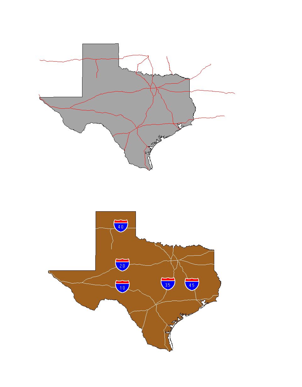
This exercise is for locating towns in which to open new retail establishments. It uses the census data and is completely generic for location. Basic functions are repeated queries using both database and graphics criteria. Any GIS software should be able to complete this exercise. Data Sets: From data delivered with ArcView, states, highways, counties, and major cities. The cities database includes population and demographic data. Software Used: ArcView 3.1
After completing this lab the student should be able to � Take a very large, complex graphics and attribute database created for many other purposes and using repeated queries reduce it to the few locations meeting the established criteria. � Prepare a map and attribute table for presentation of results.
You operate a chain of retail establishments stocking merchandise for school-age children. You have targeted Texas as your next expansion area. Your chief competitor is already well established in Texas. Their market strategy is to enter all large cities with multiple locations. Your strategy is to stay away from them and attempt to dominate your market place.
1: Create a new project called TxLocations and populate it with a new database which includes these 3 themes. � State of Texas � Major cities in Texas � Major highways in Texas (Why is this a problem? You can be creative with your graphics colors or alternatively use the geoprocessing wizard to cut off the highways at the Texas border) NOTE: The lesson of the highways, which are not indexed by state, was that sometimes you can find the data, but not get exactly what you wanted. The trick of setting colors, in this case making the highways white on a pastel background, in order to make things visible or invisible is an old trick still frequently used. Alternative technique for handling the highways. ArcView3.2 includes functionality to clip one theme using the properties of another. Look under Theme>Select by Theme. You can clip the highway file using the Texas shapefile as a sort of cookie-cutter.
2. Label the highways using the interstate marker.
3. Open the cities theme table. Turn off the extraneous attributes: shape, city fips, (fips is federal information processing standard) state fips, state name, state city, type, capital, elevation.
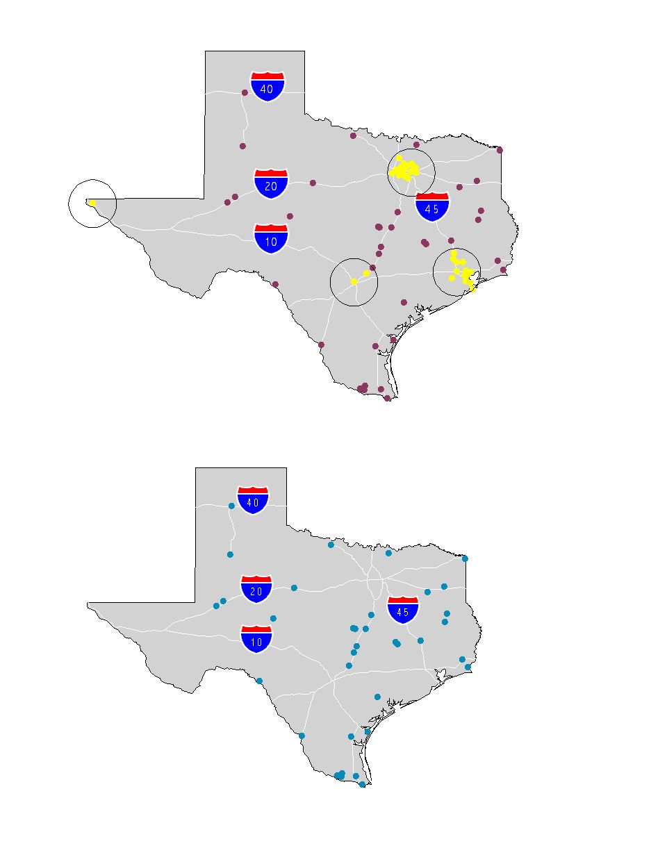
4. Identify all Texas cities with greater than 500,000 population. This criteria finds Houston, Dallas, San Antonio and El Paso. Buffer them at a distance of 50 miles. This is the area in which you will not open stores.
5. Select all cities with populations greater than 25,000, which is the minimum number to support your store. Now eliminate the cities greater than 500,000 as well as those below 25,000. Next eliminate all selected cities which lie within the 50 mile buffer zones. One way to do this is to select all cities in the buffer and reverse the selection.
6. Turn off the buffers which are no longer needed. Also remove unselected cities. Only have mapped cities which meet your population and geographic (competition there) criteria.
7. Another criteria of the population which will support your stores is that they cannot be mostly in poverty. The best criteria in this database for identifying wealth is median value of homes. Select only cities with values above $55,000 and eliminate the rest from your map.
8. Now you have identified all of the potential locations for stores from the census database. Like any good GIS analyst, you actually look at your data before you create a report. Looking at the 15 identified cities, you find an anomaly. Fort Hood, a military base, was incorrectly identified as a city. Eliminate Fort Hood from your selection.
9. Project your Texas map so that you can add distance units and a bar scale.
10. Change the symbol for the selected cities to something larger and bold. Label the cities with their names. Move text around for aesthetic purposes. Change colors as needed, also order of layers.
11. Construct your table so that you only show the 14 selected city names, with total population, and school age population. Sort the table by maximum school age population.
12. Review your geographic distribution of proposed locations. Identify a possible site for your Texas warehouse such that delivery times to all locations would be optimum. Label this location. It should be very close to one of the major highways. Note: there is optional GIS software to do this analysis, but you do not have it. This is an "eyeball" selection with no one correct answer.
Layout and print your map along with city table and scale bar.

Clark, K. C. , Getting Started with Geographic Information Systems, Second Edition, Prentice Hall, Upper Saddle River, NJ, 1999. De Mers, M. N., Fundamentals of Geographic Information Systems, First Edition, John Wiley & Sons, New York, 1997 Heywood, I., Cornelius, S., and Carver, S., An Introduction to Geographical Information Systems, First Edition, Addison Wesley Longman, New York, 1998