Authors: David T. Hansen, Barbara Simpson, Chris Curlis,
Jeff Milliken
The U.S. Fish and Wildlife Service and the U.S. Bureau of Reclamation are involved in the development of a habitat monitoring project for the Central Valley of California. As part of the project, a habitat base map is to be developed for 1993 based on existing digital data for land cover and land use. This will serve as a basis for monitoring change for 2000 and beyond. Basic methods follow techniques used in the California State Change Detection Project by the California Department of Forestry and Fire Protection and the U. S. Forest Service.
An initial step in this process is the development of a land cover or habitat legend that can integrate the available digital data and that will be consistent with other mapping efforts in California. The California Wildlife Habitat Relationships (WHR) system was selected. It was applied to six source databases for the 1993 time period. In the process of assigning WHR categories, values for uncertainty were assigned to the source legends. The six source databases were merged using spectral polygons generated from 1993 satellite imagery. This generated a combined code of WHR categories from the six sources.
These combined codes were examined to assign a WHR category to the various code combinations. In addition to assigning a WHR label, uncertainty values were assigned based on the source of the primary label and the matching of labels between sources. Code combinations carry an overall confidence value in the label assignment for use with the 1993 database.
The U. S. Fish and Wildlife Service (USFWS) and the U.S. Bureau of Reclamation (USBR) are involved in a joint program to map and monitor habitat in the Central Valley of California. Simpson and others describe this cooperative effort in a presentation and paper at this conference (Simpson, et. al., 2001). The objective for the organizations is to develop a tool to monitor habitat and land cover change. The California Department of Forestry and Fire Protection (CDF) and the U.S. Forest Service (USFS) have developed a State-wide change detection project for the areas surrounding the Central Valley (Levien and others, 1998). One objective for the Central Valley habitat project is to integrate methods and legends into the CDF and USFS State wide project. The habitat monitoring project is divided into three phases. These three phases are further discussed by Hansen (Hansen, 2001).
The first phase is to develop a land cover base map for 1993. This is a key year for the two organizations in evaluating changes in land cover and habitat. During this phase, an initial habitat legend or classification system was developed. This legend is based on the California Wildlife Habitat Relationships System (WHR) as initially described by Mayer (Mayer and others, 1988). WHR identifies general vegetation communities for California. It is in common use. Cross walks exist for WHR and other vegetation and land cover classifications used in the state. WHR is one of the classifications used in the State-wide change detection project by CDF and USFS. There are active efforts within California through the auspices of the California Biodiversity Council to coordinate vegetation and land cover mapping programs. One current objective for subcommittees working with the Council is coordination of mapping legend development that is in conformance with the National vegetation classification system (FGDC, 1997).
The base map for 1993 has been constructed from existing digital data sets of land cover, land use, and vegetation data layers. Six digital databases representative for the year 1993 were selected for processing. For each of the six sources a uniform theme was compiled. Source legends were evaluated and recoded into a WHR category with a two digit code. The six sources were merged or integrated using spectral polygons generated from 1993 satellite scenes for the project area. The spectral polygons generated from the satellite scenes have a minimum size delineation of 1.0 hectares (2.5 acres). Two digit WHR codes based on each data source were assigned to each spectral polygon. This process generated a combined 12 digit code representing the two digit WHR codes captured from each source. This processing is being presented in a paper at this conference by Curlis (Curlis and others, 2001). The twelve digit combined codes were then evaluated to assign a final WHR code based on the various code combinations.
Legend development and assignment of WHR codes consisted of three steps.
Since the process involved recoding existing land use and land cover legends into a new code, we wanted to recognize the uncertainty in the code assignment. This was done both in the initial recoding of the source legends and when an overall WHR code was assigned to the twelve digit code combination. The uncertainty for the overall WHR code of the 1993 base theme consists of two parts.
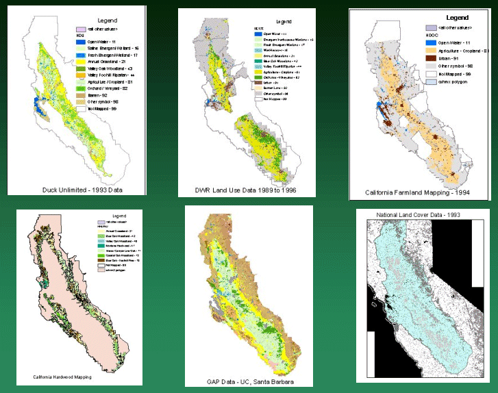
Legends from six separate data bases were evaluated and assigned to a WHR category. The six databases are:
Wetland Mapping by Ducks Unlimited (DU)
This is land cover mapping developed by Pacific Meridian and Ducks Unlimited for the California Department of Fish and Game (Ducks Unlimited, 1997). It is based on image processing of satellite scenes for the winter and summer of 1992 and 1993. Minimum mapping units for this data was about 1 to 2 hectares (2.5 to 5 acres) depending on land cover type. Chief focus for this mapping was to identify wetland habitats. It covers most of the area for the 1993 project base map. This data is a primary source for major WHR categories of:
1. Water
2. Barren
3. Riparian
4. Grassland
5. Orchards / Vineyards
6. Cropland
7. Wetlands
Land Use Mapping by California Department of Water Resources (DWR)
This is detailed crop mapping at a scale of 1:24,000. Some other land cover types are also covered including urban (DWR, 1993). Available DWR mapping for the time period 1989 to 1995. This mapping only covers a portion of the area of the 1993 base map. This data is a primary source for major WHR categories of:
1. Water
2. Urban
3. Barren
4. Grassland
5. Orchards / Vineyards
6. Cropland
Mapping of Farmland by the California Department of Conservation (DOC)
This is part of the farmland monitoring program by the Department of Conservation (DOC, 1994). Every two years, aerial photography is evaluated and active farmland mapped with a minimum mapping unit of 4.0 hectares (10 acres). The data used for this project are the farmland maps available for 1994. This database covers only a portion of the area for the 1993 base map. This data is a primary source for major WHR categories of:
1. Water
2. Urban
3. Cropland
Mapping of California Hardwoods by Pillsbury (HDWD)
Compiled data of hardwood mapping by Pillsbury and others from the early 1980's and updated in 1990 using satellite imagery by the California Department of Forestry and Fire Protection (Pillsbury, 1991). Source scale varies from approximately 1:24,000 to 1:58,000. This data covers a broad time frame and covers only portions of the project area identifying only hardwood types and mixed savannah. This data is a primary source for labels where there is agreement on WHR categories of:
1. Woodland
2. Grassland
California GAP Database (GAP)
This is mapping of major vegetation of land cover categories on a statewide basis. It was developed by the University of California, Santa Barbara as part of the National GAP program (Ca. Department of Fish and Game, 1998). The database is largely based on 1990 satellite scenes supplemented with 1:58,000 scale aerial photography. Target resolution is 1:100,000 with a 40.0 hectare (100 acre) minimum mapping unit. This data is a primary source for labels where is agreement on WHR categories of:
1. Water
2. Urban
3. Barren
4. Woodland
5. Shrub / Scrub
6. Grassland
7. Orchards / Vineyards
8. Cropland
9. Wetlands
National Land Cover Data (NLCD)
This is the recently released land cover mapping by the U.S. Geological Survey (USGS, 2000). The data for California is based on 1993 satellite imagery with a minimum resolution of 30 meters. Each 30 meter pixel carries a label for land cover. The legend for this data follows a modified Anderson system and is more general than the other sources. It is generally used to support labels from other sources except where no other data is available.
Based on the individual review of the legends from the six sources, an initial overall legend was developed. GAP provided the initial full set of WHR codes since it carries WHR as part of its legend elements. Legends from the other five sources were evaluated and assigned to one of the WHR categories or to a general category of other symbol. Several categories in NLCD are more general than the set of WHR codes. To recognize this, the overall 1993 legend is in a hierarchy following the National vegetation schema. As each source legend was reviewed and assigned a WHR code, an uncertainty value from 0.5 to 0.9 was assigned. These values are identified in the metadata for each of the sources along with the source legend value and assigned WHR category. The six source databases carry the original legend value, a two digit code for the WHR category, and an uncertainty value. Table 1 shows the structure of this legend with the WHR categories, the two digit code, and sources carrying these categories.
|
Major Category |
WHR Category (Code) |
Source Data |
|
Water |
Open Water (11) |
DU, DWR, DOC, NLCD |
|
Estuarine (12) |
GAP |
|
|
Riverine (13) |
GAP |
|
|
Lacustrine (14) |
GAP |
|
|
Urban - Developed |
Urban (91) |
DWR, DOC, GAP, NLCD |
|
Barren |
Barren (92) |
DU, DWR, GAP, NLCD |
|
Deciduous Forest |
____ (41)* |
NLCD |
|
Blue Oak Woodland (42) |
DWR, HDWD, GAP |
|
|
Valley Oak Woodland (43) |
DU, HDWD, GAP |
|
|
Valley Oak Riparian (44) |
DU, GAP, DWR |
|
|
Desert Riparian (45) |
GAP |
|
|
Valley Foothill Hardwood (46) |
GAP |
|
|
Montane Hardwood (47) |
HDWD, GAP |
|
|
Montane Riparian (48) |
GAP |
|
|
Evergreen Forest |
____ (51)* |
NLCD |
|
Closed Cone Pine Cyprus (52) |
GAP |
|
|
Juniper (53) |
GAP |
|
|
Pinyon - Juniper (54) |
GAP |
|
|
Douglas Fir (55) |
GAP |
|
|
Eastside Pine (56) |
GAP |
|
|
Jeffrey Pine (57) |
GAP |
|
|
Ponderosa Pine (58) |
GAP |
|
|
Redwood (59) |
GAP |
|
|
Red Fir (61) |
GAP |
|
|
Lodgepole Pine (62) |
GAP |
|
|
Subalpine Conifer (63) |
GAP |
|
|
White Fir (64) |
GAP |
|
|
Mixed Forest |
____ (71)* |
NLCD |
|
Interior Canyon Live Oak (71) |
HDWD, GAP |
|
|
Coastal Oak Woodland (72) |
HDWD, GAP |
|
|
Blue Oak - Foothill Pine (73) |
HDWD, GAP |
|
|
Klamath Fixed Conifer (74) |
GAP |
|
|
Sierran Mixed Conifer (75) |
GAP |
|
|
Montane Hardwood Conifer (76) |
GAP |
|
|
Shrub Land |
____ (30)* |
NLCD |
|
Coastal Scrub (25) |
GAP |
|
|
Alkali Desert Scrub (26) |
GAP |
|
|
Desert Scrub (27) |
GAP |
|
|
Sagebrush (28) |
GAP |
|
|
Low Sagebrush (29) |
GAP |
|
|
Chamise Redshank Chaparral (31) |
GAP |
|
|
Mixed Chaparral (32) |
GAP |
|
|
Montane Chaparral (33) |
GAP |
|
|
Alpine Dwarf Shrub (34) |
GAP |
|
|
Bitterbrush (35) |
GAP |
|
|
Non-Natural Woody |
Orchards / Vineyards (82) |
DU, DWR, GAP, NLCD |
|
Herbaceous Upland |
Annual Grassland (21) |
DU, DWR, HDWD, GAP, NLCD |
|
Perennial Grassland (22) |
GAP |
|
|
Planted / Cultivated |
Cropland (81) |
DU, DWR, DOC, GAP, NLCD |
|
Wetland Areas |
Emergent Herbaceous (15)* |
DWR, NLCD |
|
Woody Wetlands (19)* |
NLCD |
|
|
Wet Meadows (18) |
DWR, GAP |
|
|
Fresh Emergent Wetland (17) |
DU, DWR, GAP |
|
|
Saline Emergent Wetland (16) |
DU, GAP |
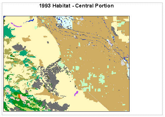
WHR categories marked with an asterisk are not recognized in the WHR system and represent general groupings for a vegetation type. In addition, every source except GAP had source legend categories that did not fit into any WHR category. These were assigned a code of 98. As can be seen in the table, only a few WHR categories have values from multiple sources. Most of the woodland and shrub categories are limited to one or two sources. Figure one shows the extent of mapping within the project area for each of the six sources. Only GAP and NLCD cover the entire study area. As explained in Hansen, the effect of limited extent for all six databases is less than might be expected (Hansen, 2001). The main focus area for the project is the Central Valley floor that is largely covered by the land cover mapping by DU for 1993. For long term habitat monitoring, data from the CDF/USFS State-wide change detection project will be incorporated for the coast ranges and the Sierra Nevada range.
As described by Curlis, the correlated habitat legend from each source was assigned to spectral polygons. The study area was divided into 58 processing areas of approximately the same size to generate these spectral polygons. For each processing area, an overlay operation was run against each of the six sources. This captured the two digit WHR legend value from each source. The result was a twelve digit combined code. To assign an overall WHR category to these code combinations, a series of Arc Macro language (AML) scripts were prepared. Initially for setting up the AML scripts, about 20 percent of the 58 processing areas were randomly selected and coded. These were reviewed against aerial photography for 1993 to identify problems in the coding process.
After this review, all processing areas were coded using the AML scripts and a summary INFO table was prepared. The summary table was again reviewed with the series of AML scripts and final adjustments made to coding. This summary table contains 15,713 unique combinations of codes from the six sources. The table identifies the step in the AML scripts that assigned a WHR category. Table 2 contains the summary statistics for major groups of the WHR categories assigned to the 1993 base map
|
Major Category |
Subcategory (Two digit WHR Codes) |
Hectares |
Acres |
|
Water |
Open Water (4) |
250,100 |
618,000 |
|
Urban - Developed |
Urban (1) |
664,000 |
1,641,000 |
|
Barren |
Barren (1) |
26,950 |
66,600 |
|
Forest |
3,281,200 |
8,108,300 |
|
|
Forest |
Woodland - Riparian (3) |
18,900 |
46,800 |
|
Forest |
Woodland - Other (22) |
3,262,400 |
8,061,500 |
|
Shrub land |
Shrub - Scrub (10) |
579,700 |
1,432,400 |
|
Non-Natural Woody |
Orchard / Vineyard (1) |
901,200 |
2,227,000 |
|
Herbaceous Upland |
Grassland (2) |
2,353,200 |
5,815,000 |
|
Planted / Cultivated |
Cropland (1) |
3,566,400 |
8,812,900 |
|
Wetlands |
Wetlands (4) |
88,400 |
218,400 |
These scripts assigned both a WHR category based on code combination and uncertainty values. Uncertainty values were assigned based on the main source for the WHR label and the number of matches in the code combination. An overall uncertainty value represents uncertainty based on the primary source of the label and uncertainty based on the number of data sources that agreed. These uncertainty values are:
Figure 3 displays the combined uncertainty in label assignment for a portion of the Central Valley. More intense shades represent greater certainty in the label assignment based on the number of sources that agree for that area and the source of the primary label.
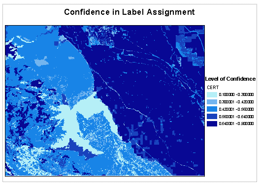
Table 3 represents the percentage of total acres where the combined uncertainty in label assignment is greater than 0.50 for major groups of the WHR categories. Values greater than 0.5 represent greater confidence in the label assigned for the 1993 habitat database.
|
Subcategory Group of WHR Codes |
Total Acres |
Uncertainty Values > 0.5 |
Uncertainty values > 0.7 |
Uncertainty Values > 0.8 |
|
Open Water |
618,000 |
94% |
79% |
56% |
|
Urban |
1,641,000 |
90% |
72% |
56% |
|
Barren |
66,600 |
11% |
10% |
1% |
|
Woodland - Riparian |
46,800 |
52% |
14% |
0% |
|
Woodland - Other |
8,061,500 |
33% |
14% |
7% |
|
Shrub - Scrub |
1,432,400 |
3% |
0% |
0% |
|
Orchard / Vineyard |
2,227,000 |
92% |
66% |
63% |
|
Grassland |
5,815,000 |
77% |
4% |
0% |
|
Cropland |
8,812,900 |
92% |
86% |
79% |
|
Wetlands |
218,400 |
97% |
73% |
22% |
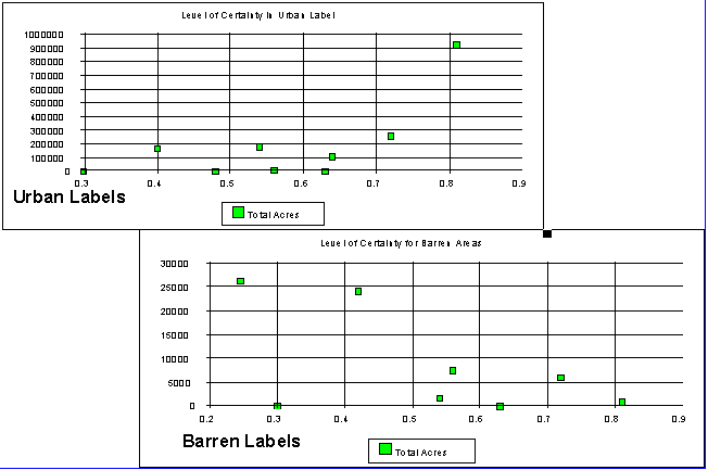
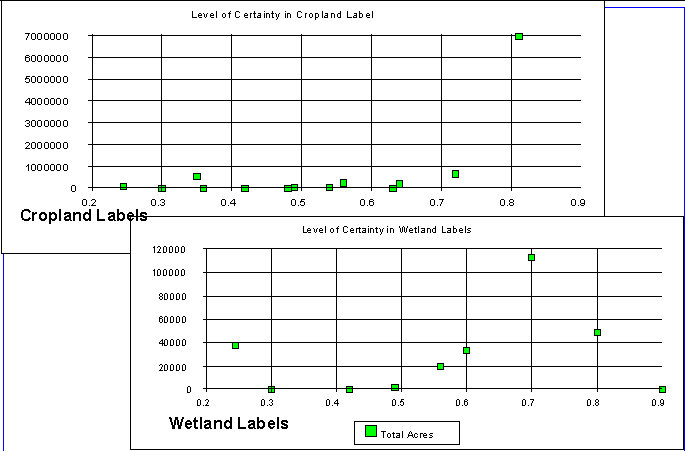
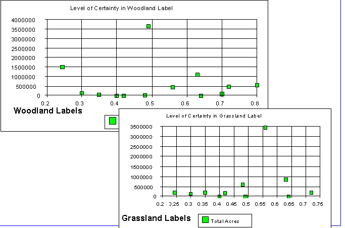
As could be seen in Figure 3 and Table 3, some areas and groups of WHR categories have very low certainty values or relatively high levels of uncertainty. Graphically, these are displayed in three figures at the end of this paper (Figures 4, 5, and 6). Higher values represent greater confidence in the label assignment for the 1993 habitat database. Where the combined value greater than 0.8, three sources agree and the primary source is from DU, DWR, or DOC. Where the combined value greater than 0.5, two or more sources agree and one of these sources is DU, DWR, or DOC.
The confidence in label assignment depends heavily on the mapping from the DU, DWR, and DOC databases. These databases are concentrated on the Central Valley floor where most the agricultural land, urban areas, and wetlands are identified. Barren areas are an exemption to this. Barren areas had limited matches in the six sources. In the initial review of the processing areas, conflicts were identified between mapping of barren areas in the DU database compared to other sources. This is apparent in the low level of confidence for assignment of barren to the 1993 habitat database.
Areas outside the floor of the Central Valley, generally have low levels of confidence in label assignment for the 1993 habitat base map. While the confidence in the label assignment for 1993 is low for these areas, change detection data developed by CDF and the USFS will replace this mapping as the monitoring program progresses. Data from CDF and USFS will improve the quality of the land cover and habitat designations for these portions of the study area.
In addition, for WHR categories that are not identified in these three primary sources, the confidence level will depend heavily on the source uncertainty value for that WHR category. This affects many of the natural vegetation categories identified on the Central Valley floor. They represent key areas for investigation as the monitoring program progresses.
The habitat database for 1993 consists of six themes representing the original source databases and a polygon theme with a vegetation code based on the WHR system. The themes for the source themes carry the original legend values and the assigned WHR code. Documentation identifies the uncertainty in that label assignment. The 1993 habitat database contains attributes identifying the combined code captured from the six sources, the WHR code assignment based on that combined code, and uncertainty values for that label assignment. The uncertainty values consist of two parts identifying the uncertainty associated with the primary source for the label and on the number of matches with other sources.
Identifying the level of confidence in label assignment along with the label is assisting in the review of the 1993 database as well as for preparing phase three of the project. The label assignment is presently under review with aerial photography for that time period and with available mapping of habitat or land cover. Areas having lower confidence in label assignment can be easily identified for review. In phase three, areas of change between 1993 and 2000 are being identified for field visits or photo interpretation. Identifying areas that have a low confidence in the 1993 label assignment can assist in ranking change areas for review. The 1993 legend is under revision by USFWS and USBR in preparing for phase three. The variation in uncertainty for the WHR categories in the 1993 legend should assist in this revision. The level of confidence for labels of an area will assist in incorporating other land cover databases to identify other habitats of interest not currently in the WHR system.
California Department of Conservation (DOC), Division of Land Resource Protection, A Guide to the Farmland Mapping and Monitoring Program , California Department of Conservation, Sacramento, CA., 1994, http://www.consrv.ca.gov/dlrp/FMMP/pubs/guide.html.
California Department of Fish and Game, University of California Santa Barbara, November, Gap Analysis of Mainland California, an Interactive Atlas of Terrestrial Biodiversity , CD-Rom, California Department of Fish and Game, Sacramento, CA., 1998.
California Department of Water Resources (DWR), Statewide Planning Branch, Division of Planning, Standard Land Use Legend , California Department of Water Resources, Sacramento CA., July, 1993.
Curlis, Chris, Jeff Milliken, Barbara Simpson, David Hansen, Putting Puzzles Together When the Pieces Don't Fit; Data Integration, Twenty First Annual Esri International User Conference, San Diego CA., July, 2001.
Ducks Unlimited (DU), California Wetland and Riparian Geographic Information System Project, Final Report, California Department of Fish and Game, Natural Heritage Division, Sacramento, CA. January 17, 1997.
Federal Geographic Data Committee (FGDC), Vegetation Subcommittee, National Vegetation Classification Standard , U.S. Department of Interior, Federal Geographic Data Committee, Washington, DC., June, 1977.
Hansen, D. T., Defining Cooperative Geospatial Projects Between Organizations, Spatial Methods for Solution of Environmental and Hydrologic Problems: Science, Policy, and Standardization, ASTM STP 1420, D.T. Hansen, V. H. Singhroy, R. R. Pierce, A.I. Johnson, Eds., American Society for Testing and Materials, West Conshohocken, PA, 2001.
Levien, Lisa M., Chris S. Fischer, Peter D. Roffers and Barbara A. Maurizi, April 1998, Statewide Change Detection Using Multitemporal Remote Sensing Data, Seventh Forest Service Remote Sensing Applications Conference, Nassau Bay, Texas.
Mayer, Kenneth E., and William F. Laudenslayer, Jr. Editors, A Guide to Wildlife Habitat of California, California Department of Forestry and Fire Protection, Sacramento CA., October, 1988.
Multi-Resolution Land Characteristics Consortium, NLCD Classification System (NLCD), URL: http://www.epa.gov/NLCD/classes.html, U.S. Environmental Protection Agency, September 7, 2000.
Pillsbury, N. H., et. al., Mapping and GIS Database Development for California's Hardwood Resource , California Department of Forestry and Fire Protection, Sacramento CA., 1991.
Simpson, Barbara, Chris Curlis, Jeff Milliken, and, David Hansen, Framework Land Cover Monitoring of California's Central Valley , Twenty First Annual Esri International User Conference, San Diego CA., July, 2001.
USBR staff would like to acknowledge the assistance of Elena
Robisch and Bart Prose as well as other members of the U. S. Fish and Wildlife Service
in this project.,
U.S. Fish and Wildlife Service,
2800 Cottage Way;
Sacramento, CA, 95825-1998.
David T. Hansen
Barbara Simpson
Chris Curlis
Jeff Milliken
MPGIS
U.S. Bureau of Reclamation
Mid Pacific Region
2800 Cottage Way
Sacramento, CA. USA 95825-1898
Phone: (916) 978-5268
FAX: (916) 978-5290
Email: dhansen@mp.usbr.gov