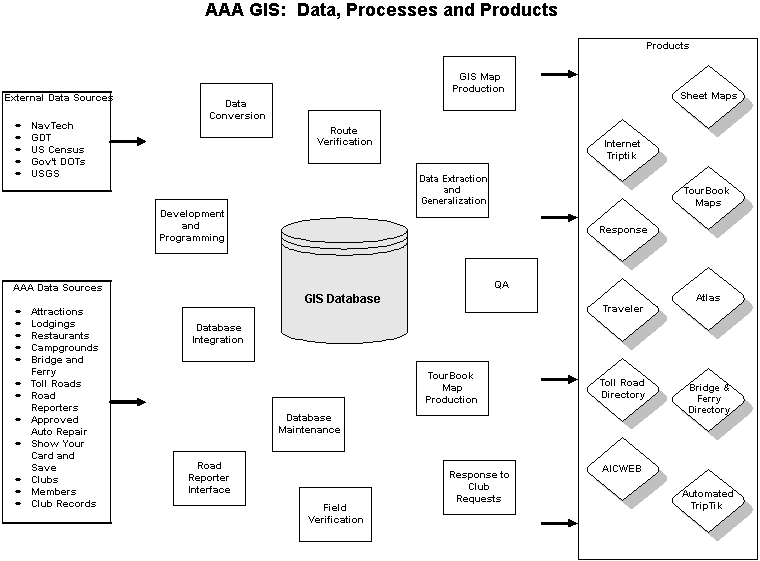
Figure 1: AAA’s GIS Master Database Processes
INTRODUCTION
AAA, formerly known as the American Automobile Association, is a thriving organization that strives to provide quality service to its members. AAA has been in the business of helping its membership and the traveling public since 1902. AAA is more than just an "emergency road service" company. It offers travel-related services, road safety education initiatives, financial services and products, and several types of publications to its forty-four plus million members in the U.S. and Canada. Assistance is readily available through its 1,152 offices, which are independently run by the 11 CAA clubs and 71 AAA clubs.
In the early days of the last century, as membership increased, so did the need to provide maps and related highway information to the motoring public. AAA’s first map was produced in 1911. Traditional inking and scribing cartographic methods were used until the first CAD-based system was implemented in 1989. At that point, the main focus was simply to produce and publish the existing paper maps using a computer system.
During that period, AAA was also in the process of building a North American database, based on the existing state map series. A major challenge with building the database was finding a cost-effective way to add attributes to the data. It was also important to have the ability to produce new products more efficiently and to provide our customers with more choices in the way our information could be delivered. This effort was hampered by the fact that other departments within AAA had developed separate databases to support different core programs such as book publishing, marketing and emergency road service. If AAA was to continue to gain additional efficiencies from further automation, it needed to build an intelligent, enterprise-wide GIS system. Therefore, in 1996 AAA implemented a GIS as an integral component of its map publishing strategy.
AAA’s GIS ENVIRONMENT TODAY
The GIS Master Database contains all the features required to generate AAA core map products. This includes the spatial datasets and their related attribute information as well as the items used for symbology, allowing the existing customized applications to classify, extract, generalize and plot the features on a given map product.
It is built on a foundation of Navigation Technologies (NavTech) and Geographic Data Technology (GDT) data. Additionally, the Master Database is enhanced with the AAA value-added features and attribution.
Figure 1 illustrates the complexities involved in creating and maintaining
a single-source, database-driven cartographic production environment. Some
of the challenges include: integrating multiple source third party and
AAA value-added data; managing a large spatial database, and ensuring data
quality for all the products generated from the database.
Figure 1: AAA’s GIS Master Database Processes
Currently, the Master Database itself resides in an Informix Spatial Database Engine (SDE) database. This environment allows multiple GIS users to carry out daily tasks including map production, database update and maintenance from within a single data source. We hope to transition to ArcSDE 8.1 later this year.
The following lines include a few highlights of AAA’s GIS database*:
Just as Esri is continually moving forward with its software design and architecture, AAA is also embracing changes on how it utilizes GIS for database maintenance, data integration and map production. The first step in this process involved becoming an ArcGIS 8.1 Beta site. During the past eight months or so, AAA decided to take a closer look at the new desktop applications to find out if they could benefit the existing map production methodologies.
The first application that ArcGIS could potentially benefit was the map design and compilation process. The main objective of this test was to determine if ArcGIS could be used as a tool for the design of AAA’s sheet maps, which include the CitiMapÔ series, as well as the state maps published by the company.
TRADITIONAL MAP DESIGN
The design stage is the vital first step in the process of creating a new map or significantly altering an existing one. Once completed, it is used to solicit customer input from the local clubs as well as management approval. Approved designs are used as guidelines by the GIS Production staff. At this stage, technicians are ready to create the individual map views and their respective extent polygons that will later become part of the map border. The technicians also utilize map generalization techniques to extract data from the master SDE database.
In order to achieve its objective, the design must communicate the most important features of the map. It also provides the precise map view dimensions as well as their respective scales for the cartographers to produce the maps.
AAA sheet maps are organized into five distinct
series: Street, Vicinity, State, Regional, and Country. The series are
based on pre-determined scale ranges and geographic detail of the area
being mapped. These products are restricted to four particular paper sizes:
19", 23.5", 25" and 36". This limited selection optimizes printing efficiency
and helps to keep production costs down. Together, the map type and the
available paper sizes provide the framework that allows the designer to
begin assembling a new map.
The procedure used before ArcGIS 8.1 was a hybrid of manual and automated cartographic techniques. During the manual component of this process, the designer used a customized legal size paper template to sketch out the map contents and its pertinent attributes, such as view dimensions and scale. Once these basic steps were completed, the GIS came into play.
The map designer utilized traditional command line workstation ArcInfo functionality to clip out a section of data from the database. These steps involved:
If in the end not enough room was available for all of the necessary elements on a particular design, the entire process was repeated on another template using a different scale or map orientation that had a better chance of producing the needed result.
Once the designer finished a layout that met all needs of both the clubs and staff, it was time to finalize the design by manually adding elements that highlighted the map’s important features. The highlights included a selection of highway shields to indicate the main road network, labels indicating the name and scale of each map element, place names to indicate city locations and map extent, and measurements for each map frame and the paper size itself. Depending on the map, additional features such as state and/or city boundaries and the coloring of main roads to highlight them would be added as well. At that point, completed designs were submitted for internal review. This first draft frequently underwent major revisions that allowed for new concepts and ideas to be considered for the design. Approved designs were then sent to the Clubs for their feedback. Their comments were also taken into account and sometimes required a complete redesign
The main disadvantage of using this process was that changes required a complete re-work of the design from start to finish. An occasional minor revision could be handled by altering the original design. At times, however, several redesigns were required before obtaining final endorsement.
Only after being approved by both AAA’s management and the Clubs were they duplicated and sent to the GIS staff to start the actual production work. As one can imagine, this was a very labor-intensive and time consuming process that allowed for very little time for revisions and updates. Having this in mind, and given the promise of an easier user experience using a robust Windows-based GIS interface, AAA decided to make the map design and compilation process its first test for the new Esri ArcGIS platform.
USING THE DESKTOP TOOLS
The ArcMap 8.1 desktop application was used extensively for this project from the first beta up to the pre-release version (build 570). Our initial goals were to streamline the map design process and to test the performance of the new desktop tools in a real production environment. Ultimately, we would like to make ArcMap the software solution to our sheet map production.
In the early stages of the 8.1 beta program, ArcMap’s performance in rendering large line coverages was not good. This was also true when identifying a feature using the Identify Tool. At that point, we dealt with sluggish performance issues as well as frequent software crashes. We also experienced problems with ArcSDE for Informix and using Maplex-generated annotation layers, and decided to concentrate our efforts on just making map designs.
In other words, we felt comfortable using the desktop tools for the design process, but actual map production was going to continue on the 7.x workstation environment. Despite some technical limitations in the early beta versions, it is fair to say, however, that the application has evolved tremendously until the final 8.1 release ArcMap’s performance is now more than adequate on a Pentium III platform with a 900 Mhz CPU and 256MB of RAM.
The same issues discussed in the previous section need to be taken into account when dealing with designing a map with ArcMap: level of geography to display, map scales, number of insets, to name a few. Once these issues have been identified and addressed, the compiler can use ArcMap’s out-of-the-box functionality to create the map design from start to finish. The following is a summary of the procedures that are now implemented at AAA for sheet map design and compilation:
The map in Figure 3 was
the design initially submitted to the Washington state AAA club for their
approval. The main feature was the large Downtown inset map of Seattle,
WA. It also contained two other homogeneous elements – a row of street-style
downtown/airport maps along the bottom and a row of Seattle-area national
park maps arranged vertically to the left of the map. Indexes of the various
elements were placed in between these groupings to separate and define
the maps.
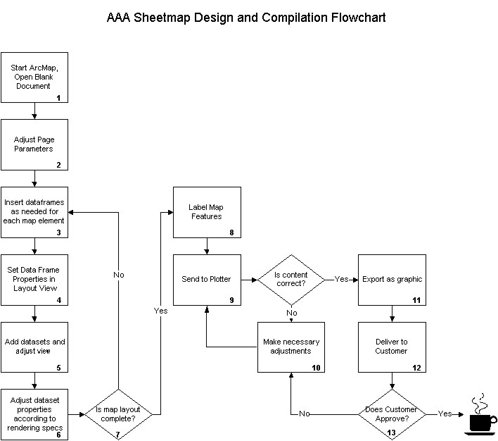
Figure 2: Simplified map design workflow using ArcMap
The club’s comments were as follows:
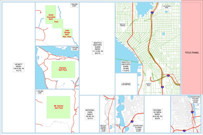
Figure 3: Original Seattle Visitor’s Guide design
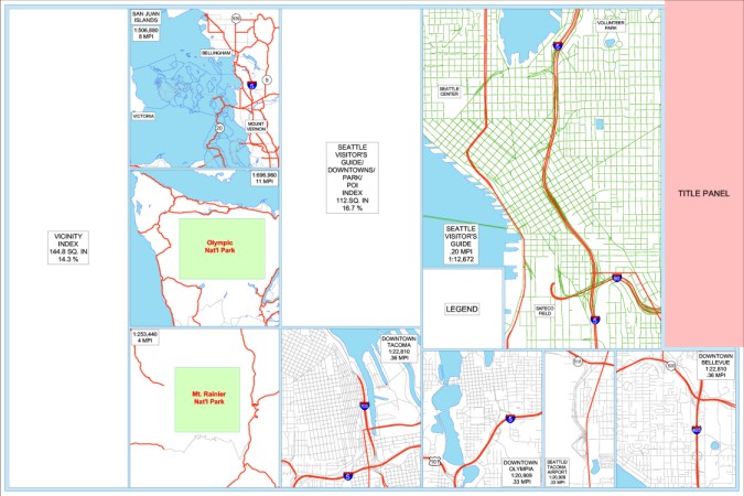
Figure 4: Seattle Visitor’s Guide design after Club recommendations
For request #3, the designer moved the Tacoma data frame next to the Mt. Rainier inset so that he could gain the extra space needed from the Seattle Visitor’s Guide index to capture the harbor area. For request #4, the designer added a view in the rectangle previously used for the Tacoma/Olympia index and shifted it to the right to be in the correct geographic location. The Visitor’s Guide index was re-sized to incorporate the additional indexes for the Tacoma/Olympia and National Parks maps.
Finally, Figure 5 shows the final published product that is now available to all AAA members at their local club. It is important to note, however, that the actual map production is still being done in ArcInfo 7.x.
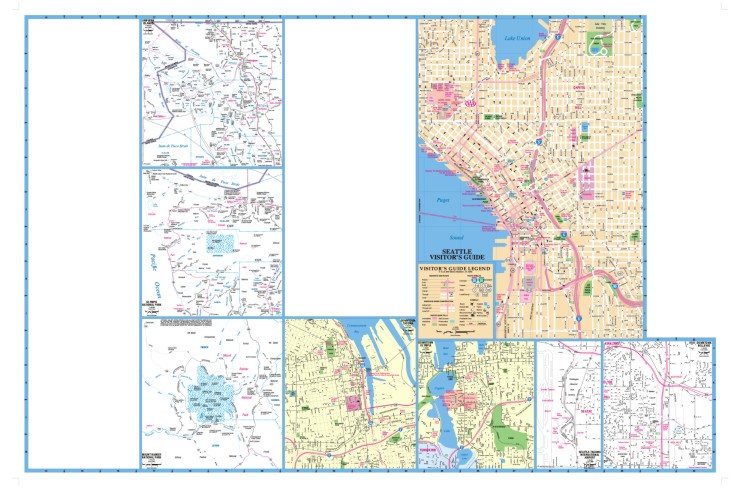
Figure 5: Published Seattle Visitor’s Guide map
KEY BENEFITS OF THE DESKTOP TOOLS
It would be hard not to recognize the tremendous progress that map designers and compilers have made using the desktop tools. The key benefits of using the desktop tools for map design and compilation are:
- Out-of-the-box functionality: there is no customization is required for this particular purpose.
- Increased productivity:
As more users become familiarized with the desktop tools interface and functionality, we expect to generate additional designs using this methodology. Our long-term goal is to take the design process a step further and produce all sheet maps from start to finish on the ArcGIS platform. We will continue to work closely with Esri and communicate to them what works well in a large map production environment and also, what enhancements are necessary to improve the software. For example, the ability to export MXD files to industry standard graphic formats such as Adobe’s .AI is an exciting advance to ArcMap. We look forward to having this functionality incorporated into the ArcGIS 8.1 core product once it is released as part of service pack 1.
Furthermore, we anticipate eventually producing all of the 600 plus AAA TourBookTM maps using ArcGIS technology. This will include map design, data generalization and extraction and product output. The improved TourBook maps will begin to be available to AAA members starting the first quarter of next year.
We hope to have some more insights to share with the GIS user community in the upcoming years. As we all know, "a picture is worth a thousand words." What makes this type of cartography interesting is all of the work that goes on behind the scene, and ArcGIS helps to make that a bit easier. So far, the results have been promising.
ACKNOWLEDGEMENTS
The authors would like to thank the following AAA Associates for their contribution to this endeavor: Miguel Garriga, Tim Kidwell, Hari Koduru and Donna Woods.
| Paulo O. Duarte | Michael L. Camarano |
| GIS Analyst | Cartographer |
| AAA GIS Development & Support | AAA GIS/Cartography |
| 1000 AAA Dr. MS 56 | 1000 AAA Dr. MS 56 |
| Heathrow, FL 327460-5063 | Heathrow, FL 327460-5063 |
| 407.444.8145 | 407.444.8018 |
| pduarte@national.aaa.com | mcamarano@national.aaa.com |