The Mississippi Emergency Management Agency (MEMA) has decided to utilize Geographic Information Systems (GIS) technology in combination with Hazard United States (HAZUS), an earthquake loss estimation program used for emergency preparedness, response and recovery planning, and disaster response operations. An agreement between the Mississippi Automated Resource Information System (MARIS) and MEMA will allow personnel from both agencies to join efforts during the preparation and response to an emergency. The focus of the partnership is to enhance the Earthquake Program, but future releases of HAZUS will include a wind and flood module. HAZUS is a PC-based GIS software package that uses census tract data and other various data layers to determine damage computed from historic and random earthquake scenarios.
This paper focuses on the purpose, data development, expansion and implementation of HAZUS software. HAZUS is the next logical step for the field of Emergency Management Agencies (EMA). HAZUS is a PC-based software package that was originally designed to be an earthquake loss estimation tool for Emergency Management. This software merges the technology of GIS and EMA. Through this partnership, users are able to quickly utilize data that will produce reports and maps during an emergency.
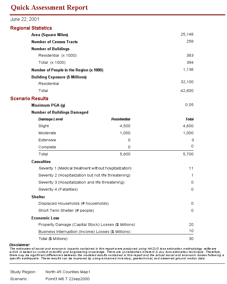
In simplest terms, HAZUS uses census data, compares it to an earthquake event, runs an analysis of a given area or point based on proximity to the earthquake, magnitude, soil types, and many other variables, and generates a report. Figure 1 The report gives estimations (based on the available census data) of how many lives could potentially be lost, different types of casualties, building stock damage, direct and indirect economic losses, etc. HAZUS essentially gives the fastest and best possible educated guess. When trying to communicate with areas that are without communication or in the "black", hours or even days can go by before a proper damage assessment can be successfully completed, assuming that the areas damaged are even going to be accessible. The information is not going to be 100% accurate or flawless; however, the information and generated reports are going to be close enough to give the executive staff members or any decision maker accurate enough information to make intelligent judgments.
Although HAZUS was originally designed to determine earthquake losses based on available data, it has now become apparent that the software has many other valuable uses. The inherent GIS capabilities that were developed inside of HAZUS bring a new dimension to the EMA field. GIS allows users to convert paper maps into a digital format. The advantage is that the digital maps can be edited rather than working with hard copy paper maps. Each feature (polygon, point or line) is dynamically linked to a record in a database, giving the map some "intelligence". The big difference in digital maps and paper maps is that the user has the ability to pick and choose different map layers that they want to view, which is ideal for conducting analysis in which maps are required. Some disadvantages of paper maps are that they have many potential problems such as storage, missing information, inaccessibility when needed, and wear and tear. Sharing data and maps can be quite difficult if different agencies are not using the same software or hardware platforms. Through GIS, multiple formats and standards are recognized, which makes GIS an invaluable asset in any type of situation that requires an analysis for a given area or region.
Given the fact that EMA uses so many different mapping formats, it is logical that EMA organizations start to use the vast mapping resources GIS has to offer. The ability to use layering in mapping procedures is critical when it comes to saving time and properly allocating resources in order to get the most "bang for your buck" when dealing with finite assets. GIS and EMA should be a partnership made in heaven. In the past few years, this has become more and more evident. Moving Emergency Operations Centers (EOC) from magnetic erase boards and hanging maps to digital projectors and easily updated computer screens is definitely the EMA of the 21st Century.
A topic that is of vital interest to HAZUS users is the procurement of accurate, reliable data. This should not be a critical problem if the user started collecting the data. Since it is possible to import entire databases into HAZUS provided that there is a unique ID or related field, the possibilities and sources are virtually infinite. In Mississippi, the (MARIS) group maintains a vast amount of data for the state that is free and accessible through the Internet. Some of their data includes: aerial photos for the entire state, scanned topographic maps (USGS 7.5 Quads), Roads, Water, Political Boundaries, etc. Mississippi Department of Transportation (MDOT) has excellent road and bridge data that includes database information about the age, type, conditions, and inspection dates of these layers. (MEMA) has a great deal of data that is maintained on site. Computer Aided Management of Emergency Operations (CAMEO), which maintains a list of all hazardous materials that are required to be reported to the state, is an excellent source of information that can easily be mapped and taken into consideration when doing analyses of potential hazards. This list maintains locations, quantities, types, and much more information about hazardous materials in the state. The NFIP maintains an outstanding source of repetitive loss structures and FIRM maps that can easily be overlaid into a digital map. There are countless agencies and accessible databases that can be transformed into a map layer to be applied to any desired application that the user chooses. Cooperation has been excellent when requesting copies of data and databases that some agencies have literally spent years developing.
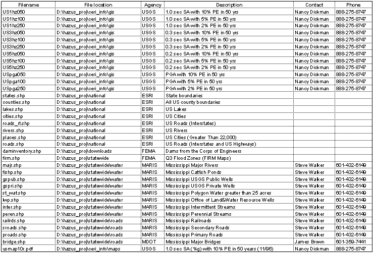
One critical problem that must be addressed early in the data collection phase is storage and management. Take into consideration early on that there will be some files that take up enormous amounts of space. Once the user starts collecting additional data layers for potential HAZUS uses and applications, there needs to be some mechanism for managing the data. Consider dedicating file folders, making hard copy maps by layer and compiling them in a 3-ring binder that can be quickly browsed and accessed. Each page in the binder should have a complete file directory defining where it is located in the computer. Maintaining hundreds of different layers makes it virtually impossible to remember where all files are located. Figure 2 Additionally, less qualified and inexperienced people unfamiliar with the HAZUS software will find it easier to select maps by viewing a hard copy of it and telling the operator what it is they need to see. This will minimize the amount of people that need to be trained to run the HAZUS software as well. If properly organized, HAZUS should be completely mobile. The data layers and metadata relating to those layers can be copied to CD-ROM, transferred to laptops and operated in the field or in a remote location.
Currently a wind and flood model is being developed by the Federal Emergency Management Agency (FEMA) and should be released in 2002. The wind model will allow users in the Atlantic and Gulf Coast regions of the United States to estimate hurricane winds and potential damage and loss to many types of buildings. The flood model is capable of assessing riverine, coastal, and alluvial fan flooding. Significantly, the earthquake, wind, and flood models will all estimate the following: direct and indirect economic losses, debris generation, at-risk populations, building stock damage, sheltering requirements, etc. The concept is solid, as it takes a given study region and applies a different disaster using the same variables, making HAZUS an ideal platform for numerous EMA software types to follow suit.
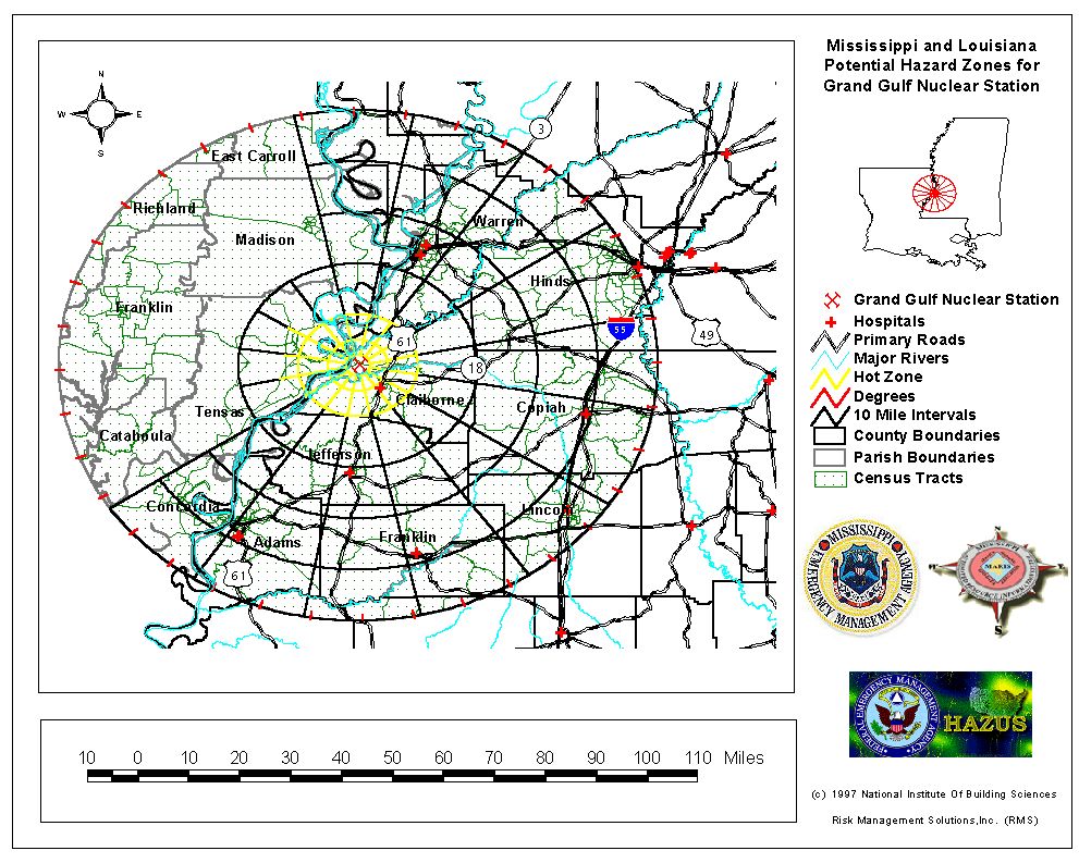
Manipulating the application, Mississippi has experimented with nuclear power plants by applying the same principles of loss estimation to it. By taking a selected area that has a nuclear power plant, in this case Grand Gulf Nuclear Station, and using the census tract data to perform an analysis of the affected or potentially affected area, it is possible to predict and track potential radiation hazards that may be present. Figure 3 An assortment of data layers were chosen and mapped, for example: degree intervals, distance intervals, county lines, state lines, primary and secondary roads, and census tracts. With the provided data, additional information would be wind speed and direction, weather conditions, amount of hazardous release, and a few other variables that are required to plot potential fallout areas. The result would highlight the areas that need to be evacuated or isolated. This theory would be absolutely critical when it comes to planning an effective response. The same technology that the US Military uses when it plots a downwind nuclear, biological, or chemical hazard would be an ideal addition for HAZUS. This addition would require little effort. The same principle is used by the Areal Locations of Hazardous Atmospheres Evaluation (ALOHA) software, which is primarily used by first responders and EMA personnel. By using the given characteristics of a specific hazardous material and taking the same meteorological variables into consideration, it generates a plume around the affected area.
Combining these EMA disaster application software capabilities simplifies the use and greatly expands their functionality. HAZUS should be the standard used to run these multiple applications as it provides the most comprehensive tools available. The amount of money saved on training alone would justify the cost for hardware. The HAZUS software itself is free. Additionally if everyone was using HAZUS as their standard EMA software, the proficiency would be dramatically increased since the user would be primarily working with the same software. This would also increase the user community, which enables users to share ideas and expand skills beyond their own experiences.
On September 3, 2000, there was a 5.2 magnitude earthquake in Napa Valley, California. HAZUS ran the scenario based on its available data and came up with a $90,000,000 estimate shortly after the event. The original Preliminary Damage Assessment (PDA) that was conducted came in around $65,000,000. Since earthquake damage totals tend to rise with further inspections that occur in the months following an earthquake, the state has viewed the immediate post-event estimate produced by HAZUS to be quite accurate. There are a few holes or incomplete data fields in the software, which leaves it up to the user to acquire the information. There has been much discussion about the usefulness of HAZUS for a given community, state, or region because of these gaps. These gaps or holes are not necessarily a problem when it comes to running HAZUS, which will be discussed later.
The HAZUS software can be most effectively implemented by allowing the individual state to maintain the software and generate the data layers. The state will get the desired data from the local level, maintain a copy of it, and generate a usable data layer that can be used in HAZUS. The state will then send the local level a copy of the layer that was generated, thus eliminating the need to have a skilled GIS professional on staff at the local level. The state should also send a copy of the data layer to its FEMA Region where it can be maintained as well. The FEMA Region should send a copy of its data layer to FEMA Headquarters.
For a response, HAZUS can be an ideal tool for an Operations Section, considering the speed and conveniences the software has to offer. When responding to an earthquake in a "black" area where communications are nonexistent, the user can start coordinating resources and assets. This provides a general idea of what is going to be needed and can be predetermined. If a bridge has an X% survival estimate that HAZUS has assigned it based on the provided data by the Department of Transportation (DOT), then an adequate idea can be achieved of what bridges and other critical facilities need to be inspected for usability and assigned a priority order listing based on whatever variables the user deems necessary. Additionally, DOT can provide updated data on bridge and road inspections to the HAZUS user, and the user can map safe and accessible pathways through the affected area in order to get whatever aid may be needed to any given point safely. By doing this, it is possible to print the map that the user has generated and distribute it to any given party, thereby maintaining a uniform flow of information.
Planning sections of EMA's can definitely use the HAZUS software to run the "What IF" scenarios. For example, if an at-risk community wanted to know how a specific magnitude earthquake would affect them, then a scenario could be generated with the desired data and a planning analysis could easily be achieved. The result of such an analysis without actually experiencing the event has the potential to save lives, property, and preserve the economic matrix of the community itself by identifying shortfalls and taking proper steps to mitigate potential hazards. Additionally, the report that HAZUS generates is an excellent source of information to give local legislators, governor's staff, or any inquiring political entity needing specific information on what they are potentially facing, because the census tract boundaries are so precise.
Training and Exercise Sections could use the HAZUS software to generate excellent and accurate training scenarios for disaster-specific events. A map can be queried by a specific point, giving a clear understanding of the current situation. When a regional exercise is being conducted that may cross state lines, the ability for all concerned agencies and organizations to be looking at the same maps is highly desired in order to minimize or eliminate communication problems.
Mitigation Sections can use this to help identify repetitive loss structures with the National Flood Insurance Program (NFIP). By taking the database that the NFIP maintains on repetitive loss structures and filtering them through a street addressing software program, it is possible to map an entire database. This concept can be applied to any database form having a street address field, regardless of the size of the database. Currently the NFIP is digitizing the Flood Insurance Rate Maps (FIRM). Many of these FIRM maps are complete. By selecting a study region, overlaying a census population, and adding the overlaying FIRM map, one can easily see approximately how many individuals are going to be affected. The additional applications for any section of an EMA are too numerous to mention.
Transferring data from the state level to the federal level should not be a difficult goal to achieve. FEMA Regions and Headquarters already have GIS professionals on staff. The real problem would be from the States. If FEMA would authorize and fund one GIS position per state for all 50 states, then this goal could be achieved. The partnering of an "Operator" (a GIS tech) and a "USER" (a qualified EMA person who understands the EMA concept and can interpret the HAZUS reports) would be the optimal candidates to run the HAZUS program for a state. It would cost approximately $100,000 per state, which would be somewhere around $5,000,000 annually. Consider a mandate requiring the states to be responsible for all the equipment necessary to run the HAZUS program. In most states, this equipment already exists. The basic requirements to run HAZUS are a standard PC with a large hard drive (approximately 10 - 20 Gigabytes), some supplemental software and a large plotter for printing maps.
The data collection phase is one of the most important aspects of using the HAZUS software. Accurate, reliable data is the core of the database, or "brain" of the system. Bad data equates to inaccurate results. Therefore, acquisition procedures must be standardized and maintained in order to achieve the maximum benefits of the software. Also, data organization is a critical factor. Accurate data is almost worthless if it cannot be retrieved in a quick and organized manner. During a disaster, political entities need information immediately, so having an organized structure for the data layers is a must.
The HAZUS software is expandable. This capability allows developers the opportunity to combine future technology with the existing interface. The wind and flood models will enable EMAs to utilize HAZUS with a broader variety of disasters. The HAZUS interface is unencrypted, allowing the operator to modify any desired model. The HAZUS developers should also consider the addition of a plume model in order to fully utilize the analysis of hazardous materials.
Lastly, imagine a disaster situation where the local, state, and federal levels of government were all looking at a given disaster plotted on different maps. Although the maps would include all the same data, the amount of confusion that would be involved and the sharing of the information would literally be overwhelming. In that same scenario, using standard software such as HAZUS, maps can be easily shared and analyzed. HAZUS can and will simplify most aspects of EMA if properly used and maintained. Moving EOCs from an erasable marker board to digital projections, automated reports and fast, accurate maps is the result of this type of implementation. HAZUS can and will work for all states and most disasters. With the proper data management, it can inevitably result in the saving of lives and the protection of property.
The authors of this paper would like to acknowledge and thank the following people, agencies, and organizations for their assistance in the support and development of this project: MARIS and Staff, MEMA and Staff, MS DOT, MS Department of Education Office of Safe and Orderly Schools, FEMA Headquarters and Regions IV and IX, Dr. Kenneth Taylor, Jim Buika, Joe Rachael, Grand Gulf Nuclear Power Plant and the EOC Staff, MS Department of Radiological Health and Staff, Dr. Pao-Chiang Yuan of Jackson State University, John Ingargiola, GDT, Paul Davis, Stephen Pate, Central United States Earthquake Consortium and Staff, National Earthquake Hazards Reduction Program, Claire Drury, Elizabeth Lemersal, and all the instructors and developers of the HAZUS software.
Patrick Wanker
Earthquake Program Manager, Mississippi Emergency Management Agency
Phone: 601-960-9976
Fax: 601-960-9983
email: Jwanker@aol.com
Author Link
Rusti Liner
GIS Project Manager, Mississippi Institutions of Higher Learning
MARIS Technical Center
Phone: 601-432-6360
Fax: 601-432-6893
email: rustil@ihl.state.ms.us
Author Link