E-Government and Internet Mapping Solutions using Geographic Information Systems (GIS)
Prepared for the Esri International User’s Conference
July 7 – 13, 2001
San Diego, California
Written by: Ravi Nigudkar (Independent Consultant)
&
Don Hoag (Deloitte Consulting)
Title:*
Abstract:*
Introduction:*
Methodology:*
Deloitte Consulting-Client GIS Team Creation:*
Figure 1: GIS Project Team Organization Chart*
GIS Mapping Solutions Project Phases:*
Figure 2: GIS Mapping Solutions Project Phases*
GIS Project Tools:*
Project Workplan:*
Project Timeline:*
Figure 3: Tactical Phases for Implementing GIS Tools*
Standards Adherence and Creation:*
Project Design and Development:*
State Of Pennsylvania Department of Public Welfare:*
Figure 4: DPW Operating Environment Diagram*
Enterprise Data Warehouse Integration:*
Current Environment:*
Figure 5: GIS Mapping Production/Development Environment*
User Workgroups:*
Geocoding Software Integration:*
Needs Assessment:*
Necessary Features of Geocoding Systems:*
Selection Criteria and Assessment:*
Observations:*
Figure 6: Geocoding Results with Relaxed Conditions*
Figure 7: Geocoding Results without Relaxed Conditions*
Maps Developed:*
Childcare Providers in ArcIMS:*
Figure 8: Childcare Providers ArcIMS Application County Zoom Level*
Figure 9: Childcare Providers ArcIMS Application Zip Code Zoom Level*
Figure 10: Supplemental Childcare Providers County Hyperlink Report in ArcIMS*
Figure 11: Supplemental Childcare Providers Zip Code Hyperlink Report in ArcIMS*
Employment and Training Programs in ArcIMS:*
Figure 12: Employment and Training Program ArcIMS Application*
Figure 13: Supplemental ETP County Hyperlink Report in ArcIMS*
Personal Care Homes in RouteMap IMS:*
Figure 14: Personal Care Homes Initial Map View ( ) in RouteMap IMS*
Figure 15: Personal Care Homes Find Feature ( ) in RouteMap IMS*
Figure 16: Personal Care Homes Route Feature ( ) in RouteMap IMS*
ETP and Childcare Providers in RouteMap IMS: *
Figure 17: ETP
and Childcare Providers Map Customized in RouteMap IMS *
Office of Income Maintenance Philadelphia Information Map
in ArcIMS: *
Figure 18: OIM
Philadelphia Information ArcIMS Application *
Figure 19: OIM
Philadelphia Information District Map by Cash *
Figure 20: OIM
Philadelphia Information Zip Code Map by Food Stamps *
Documentation: *
Portal
Implementation: *
Figure 21:
Portal Implementation for Offices at the Department of Public Welfare *
Benefits: *
Conclusion: *
References: *
Title:
E-Government and Internet Mapping Solutions
using Geographic Information Systems (GIS)
Abstract:
E-government solutions require mapping of welfare and
provider data by agencies that provide public services. These maps then
facilitate reports, studies, and policy development. This paper illustrates the
use of GIS in the realm of Internet technology for providing mapping solutions.
County/State welfare offices want to analyze welfare data and understand the
performance measures and distribution of providers and services. County managers
would like to spatially (via maps) ascertain from their data the performance of
different welfare and social services provided by different counties. The paper
describes the implementation of time-tested projects developed on ArcIMS and
RouteMap IMS platforms.
Introduction:
With the advent of the Internet and the explosive growth
in Internet commerce, the concept of electronic government as well as the use of
the Internet to serve as means of carrying out government business could not be
ignored by agencies of the local, State or even the Federal government. Many
State and Local government agencies in the United States began to concentrate on
e-government initiatives in an effort to ‘modernize’ and ‘reinvent’ their
governments. So what is E-government?
E-government means using digital technology to enable
citizens, taxpayers and browsers to access information and services from a given
governmental entity, such as an office, department, bureau, commission or
agency. The websites or portals enable contacts between the e-government entity
and the stakeholders in e-government. These stakeholders generally include the
public, the vendor community, and officials from other state/local or federal
governmental entities.
Currently many state and local governments use
time-consuming, labor intensive, paper-based procedures for accepting and
processing applications that have anything to do with government policies and
business. The e-government ‘initiative’ reduces this long drawn processing of
information by electronically strengthening the relationship between the public
and state through effective and efficient information exchange, while reducing
the cost of that information delivery. The ‘initiative’ involves increased
collaboration within different government organizations as well as the public.
The solutions for e-government ‘initiatives’ would depend on the use of
innovative technologies that can be deployed via the Web. Typically an
e-government ‘initiative’ includes services such as online tax filing (for state
or personal property taxes), registration of motor vehicles, applying for
business and other licenses, searching for property within the flood zone
insurance program (FIRM), and other citizen commentary and code enforcement.
In each of these examples, there is a geographic
component associated with information delivery or exchange of data. The digital
technologies and the solutions based on them include GIS and XML. Geographic
Information Systems (GIS) are a electronic information systems that analyzes,
integrates, and displays information based on its location. GIS is a powerful
visual display tool that presents the results for an analysis via a map using a
wide variety of scales. GIS is a technology that can create "on-demand" maps for
the user to enable visualization and exchange of data, whose common attributes
are associated to a place and geography.
In the past, GIS data had to be modified for different
GIS applications. However, the increased capacity in data storage technologies
and the integration of large-scale legacy systems into Enterprise Data
Warehouses (EDW), coupled with more powerful desktop computers, allows major GIS
vendors to focus on developing software that will access data without
time-consuming modifications. Increased accessibility will allow the user to
perform spatial analysis of once-separate datasets, previously stored and
maintained in legacy systems. More importantly, the State and County managers
can now analyze their information using GIS tools through a visual medium.
The Extensible Markup Language (XML) is an important
emerging technology that has proven to have a significant impact on the Internet
information exchange. The process of connecting different systems has been made
simpler, thus allowing the exchange and delivery of information much easier. The
XML technology has solved the most pervasive problem: data exchange. It is
emerging as an universal data exchange communication standard capable of moving
information across different platforms and different applications to funnel all
data exchanges. XML finds its use in GIS. The government agencies involved in
the e-government initiative also see XML’s potential to cure its on-going data
integration woes.
The Department of Public Welfare for the Commonwealth of
Pennsylvania has extensive welfare data by several Program offices on the
citizens of the Commonwealth.
Some of that data includes the location and distribution
of Childcare centers and vocational facilities of youth, for Office of Child,
Youth, and Family Services (OCYFS), and information on Employment and Training
sites (ETP) for the Office of Income Maintenance (OIM). In addition, data on
Retirement homes, welfare recipients’ Personal Care homes, and Nursing
facilities are also stored on the Enterprise Data Warehouse (EDW) for the Office
of Social Program (OSP). This data is accessed by county caseworkers and welfare
administrators for evaluating the effective quality of the instituted welfare
programs of the Commonwealth.
This paper describes in detail how the GIS team created
the GIS Portal and applications for implementation of an enterprise-wide
comprehensive GIS mapping solution those incorporating spatial data requirements
for different Program Offices while accommodating their different needs.
Methodology:
Health and human services agencies today are faced with
tougher challenges than ever before. Many of these challenges stem from
government’s increasing focus on performance and outcome management – requiring
agencies to orient toward customer service, to produce measurable program
improvements, and in some cases, even to make a lasting change in the lives of
their clients. And agencies are making progress toward these goals. But they’re
finding that one of the biggest challenges to surmount involves the management
of information – and the ability for time-crunched leadership and management to
quickly and easily find the information they need among the silos of data
dispersed across agencies throughout the state. Consolidated information is
critical to helping health and human services agencies successfully improve
their performance, and the outcomes of their clients.
Deloitte Consulting is in a strong position to
incorporate GIS into the modern public sector enterprise and allow these
agencies to find and use their information. Health and human services agencies
are increasingly turning to GIS to help them display, explore, and understand
the huge amounts of information that face them. These GIS solutions have helped
agency personnel make better-informed decisions, increase their ability to
analyze and use information, and ultimately improve program effectiveness across
all the agencies a GIS solution supports.
Deloitte Consulting has worked with welfare, employment
and training, child welfare, childcare, and health agencies to build GIS
solutions that integrate various aspects of the programs. In order to
effectively manage the integration process, we’ve found it makes sense to start
with the most critical information, and then add related information in stages.
This allows our consultant-client teams to quickly see the results of their
efforts; it also allows us to quickly incorporate their feedback into future
iterations of GIS solutions.
We’ve found that technology alone does not make an
effective GIS solution. It is imperative that a GIS solution be built with an
unyielding focus on the people who will ultimately use it. This means that the
end-users must be intimately involved every step of the way, so in the end the
GIS solution will fit the particular information needs of the agency.
We work side-by-side with our clients to identify the
types of information they need to analyze in order to better manage their
programs and improve client outcomes. This information is organized into three
tiers: themes, critical success factors, and measures. Themes are the general areas an agency needs to focus
on in order to reach its overall goals. For example, an agency charged with
moving people from welfare to work might identify promoting "personal
responsibility" as one theme they want to work toward with their clients.
Because it would be very difficult to quantify a theme
such as personal responsibility in a given client, the next step is to determine
the main conditions that support the theme. These conditions are called critical success factors. In the case of the personal
responsibility theme, critical success factors include quantifiable client data
such as average education level and employment trends. Finally, measures provide the broad foundation of basic
information "slices" or "views" used for reporting and analysis. In our example,
measures may include demographic information such as gender and other factual
information such as the programs a client is currently enrolled in.
Because different people within an agency need different
types and levels of information, our mapping solutions typically support several
ways by which users can interact with their data. These range from simple color
ramping and ad hoc report generation, to analytical GIS maps that identify
meaningful patterns in the data, to advanced decision-support functions. Users
access these tools via client/server and Web-based or browser-based
navigation.
Deloitte Consulting devises methods and tools that can
benefit our clients by increasing the efficiency of a GIS team. When Deloitte
Consulting approaches GIS at our client’s site there are four main areas that
initiate all GIS solutions. These four areas are the creation of a joint
Deloitte Consulting-Client GIS Team, developing the GIS Mapping Solutions
Project Phases, adhering or creating Standards, and developing the strategy for
implementing E-Government solutions.
Deloitte Consulting-Client GIS Team
Creation:
Deloitte Consulting works hand-in-hand with our clients
to create the most viable solution possible for the client’s needs. In order to
do so, Deloitte Consulting develops a GIS team comprising of Deloitte Consulting
practitioners and client personnel. This team is responsible for all the GIS
work involved at the client site. Deloitte Consulting will initially lead the
effort and incorporate all the necessary tools and knowledge while gradually
transferring those tools and knowledge to the client. At the end of the
engagement, the client will be able to self-sustain their GIS work. The GIS team
will be responsible for taking mapping requests, managing the resources
allocated to those requests, and completing all the necessary steps to include
the map in the "production" environment.
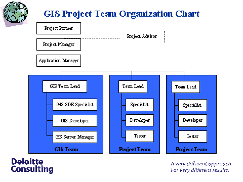
Figure 1: GIS
Project Team Organization Chart
In order for the group to take mapping requests, the GIS Team needs to incorporate two
formal request structures. The first form is accepting requests from user
workgroups. Workgroups are generally created in technical environments to test
the inclusion of new data into a system, to take user requests, and develop
applications. Workgroups tend to focus on their area of specialty and are
capable of generating GIS requests based on their own data. A less formal method
of gathering requirements will come from this group, where GIS team members will
illicit mapping requests from workgroup members.
A more formal method of procuring GIS requests is the
creation of a Data Processing Service Request (DPSR). Variations of DPSRs exist
in every IT department of organizations, but the essential functionality is for
a person or department to generate a request for technical/informational
service. DPSRs can be implemented over the Local Area Network (LAN) as a web
form, submitted directly to the servicing department in question, or exist as a
verbal commitment later described on paper. An existing DPSR can easily be
adapted to fit the needs of the GIS team. This document formalizes the structure
of requests for GIS services because the author of the DPSR must collate a
certain amount of information in the format required by the DPSR and the form
implies ownership of the GIS services provided.
A second responsibility of the GIS team is the management of resources allocated to GIS service
requests. Ideally, GIS resources are devoted to tasks that add the greatest
value to the organization. Deloitte Consulting has found through extensive
project experience that the best model to follow when devoting GIS resources is
the 10/30/60 framework. The framework attempts to categorize the types of
requests to the GIS team, generated by user workgroups, into three categories:
Ad Hoc, Static, and Dynamic. Furthermore, the framework guides the GIS Team’s
devotion of resources based on the types of projects undertaken, the amount of
data involved in creating the projects, and the number of users of the final
maps.
Ad Hoc requests are those requests where the type of
project fulfills a limited need because the business question the map answers is
limited in scope, the amount of data utilized in the map is often small, and the
number of users specified on the DPSR is low. The number of maps generated by
these requests is lower than other request types (usually only one map). Also,
the maps created should be less functional in nature; these maps would require
less effort to develop, are usually not refreshed with new data, and are not
entered into the data warehouse environment. These types of requests should
require only 10% of the GIS Team’s resources.
Static requests are those requests where the type of
project fulfills a larger need with a wider scope, the amount of data utilized
in the map is larger than Ad Hoc requests, and the number of users specified on
the DPSR is higher than Ad Hoc requests. The number of maps generated by these
requests is higher than Ad Hoc requests. Also, the maps created have moderate
functionality since their use is a static view of data; these maps require more
effort than Ad Hoc requests to develop, are usually minimally refreshed with new
data, and are entered into the data warehouse development area and possibly the
production area. These types of requests should require up to 30% of the GIS
Team’s resources.
Dynamic requests are those requests where the type
of project fulfills the largest need with the widest scope, the largest amount
of data is utilized in the map, and has the largest number of users specified on
the DPSR for the organization. These types of requests will generate the most
maps of the three types. Also, these maps will have the most advanced
functionality since their use is a dynamic view of the organization’s data;
these maps require the most effort to develop, are refreshed with current data
on a regular schedule, and are entered into the data warehouse development area
and then migrated to the production area.
The third responsibility of the GIS team is to move the
map to the production environment. Technical
projects often develop two logical environments into their work plan. The
environments are almost identical in every way, but their uses differ widely.
Often, technical staff will store these environments on different servers in
order to reduce conflict between applications. The two logical environments are
the development (or staging area) and the production environment.
The development environment
is a staging area for all new applications and data. Application development
requests are processed first in the development environment. This environment
possesses an identical structure to the production environment so that
developers may test new applications and data without disruption of the normal
services in production. Application development and testing may include load
balancing, customizing user interfaces, stress testing, and incorporating new
data into a previous production unit. No end users have access to the
development environment.
The production environment
is the final area for all tested applications and data. Finalized applications
are stored in the production environment after the appropriate user group signs
off on the application or data. End users have access based on their user class
to the production environment.
GIS Mapping Solutions Project
Phases:
In order to develop the most robust and capable
applications GIS development must follow an iterative process. Iteration allows
the developers to explore the user’s requirements and culminate those requests
into a working application. The ultimate goal of any GIS development project in
the Health and Human Services area is to create the most useful application
possible that benefits the largest amount of people. In order to attain this
goal the GIS development team must follow five phase when approaching a new GIS
project.
Strategy is the first phase in the GIS Mapping
Solutions Project. The strategy phase determines the scope of work that the
project will undertake and defines the goals needed to guarantee success of the
project. When the scope and goals are properly defined at the onset of the
project the final outcome of the process will better represent the needs of the
users. This phase would determine the audience of the mapping solution, the
interaction the user group would have with the application, and the means of
access for users.
Design is the second phase in the GIS Mapping
Solutions Project. Here, the GIS team will determine the detailed user
requirements and begin creating the initial view of a mapping solution that
meets the requirements. Detailed user requirements are obtained through
interaction with user workgroups, but might also come from commonly used
documents, frequently used web pages, and internal operational programs. The
initial design serves as a high-level guide to the mapping application that will
be developed and involves the input from multiple user types.
Develop is the third phase in the GIS Mapping
Solutions Project. In this phase the developers will create a fully functional
mapping solution that the users will test. This map should adhere to the designs
developed in the previous phase.
Deploy is the fourth phase in the GIS Mapping
Solutions Project. After developing the mapping solution, the GIS Team will
deploy the mapping solution over the internet through a GIS portal communication
medium. This portal will give access to the proper user group while providing
the necessary functionality determined in the initial phases.
Manage is the fifth phase in the GIS Mapping
Solutions Project. In managing the mapping solution the GIS Team can identify
any issues that surface through implementation. Training on the mapping solution
also comes out of this phase as increased numbers of users interact with the
map. Also, the GIS Team will monitor the system for potential enhancements and
any change in requirements through interactions with greater technology and the
user workgroups. Iteration occurs at every step in the process as the
requirements change and the necessary functionality changes.
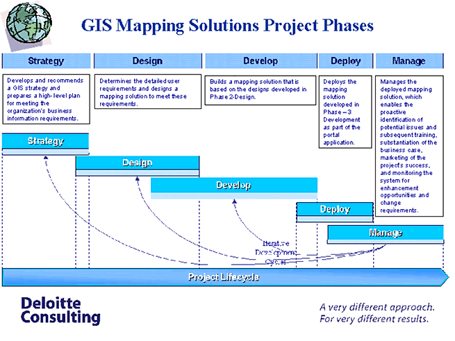
Figure 2: GIS
Mapping Solutions Project Phases
GIS Project
Tools:
The examples below are necessary components of any GIS
project. The two documents set a generic work plan for each mapping project
given to the GIS Team. Also, a phased timeline describes the implementation of
GIS initiatives in an organization.
Project
Workplan:
|
ID |
|
|
Task_Name |
Duration |
Predecessors |
|
1 |
Map |
|
|
113 days |
|
|
2 |
|
Development |
|
29 days |
|
|
3 |
|
|
Requirements Gathering |
21 days |
|
|
4 |
|
|
Create Project Folder on Development
Server |
1 day |
|
|
5 |
|
|
Prototype Development |
21 days |
4 |
|
6 |
|
|
User Design Signoff |
7 days |
5 |
|
7 |
|
Production |
|
63 days |
2 |
|
8 |
|
|
Design ETL Process |
21 days |
|
|
9 |
|
|
Data Validation |
21 days |
8 |
|
10 |
|
|
Develop Production Documentation |
7 days |
9 |
|
11 |
|
|
User Implementation Signoff |
7 days |
10 |
|
12 |
|
|
Complete Documentation |
7 days |
11 |
|
13 |
|
ArcIMS Map Migration |
|
21 days |
7 |
|
14 |
|
|
Convert shape files to an axl file |
3 days |
|
|
15 |
|
|
Create website in ArcIMS designer |
3 days |
14 |
|
16 |
|
|
Customize website |
10 days |
15 |
|
17 |
|
|
Migrate Documentation |
5 days |
16 |
Project
Timeline:
Figure 3:
Tactical Phases for Implementing GIS Tools
Standards Adherence and
Creation:
Any standard created for the Department of Public
Welfare in the State of Pennsylvania is based on the standards defined by the
National Spatial Data Infrastructure.
Executive Order
12906 calls for the establishment
of the NSDI, defined as the technologies, policies, and people necessary to
promote the sharing of geospatial data throughout all levels of government, the
private sector, the non-profit sector, and the academic community. Several
agencies act as agents to the NSDI to develop and promote standards including
PASDA, PAGIC, and the FGDC.
The Pennsylvania Spatial Data Access (PASDA) is Pennsylvania’s official geospatial
information clearinghouse and the Commonwealth’s node on the NSDI. The
Pennsylvania Geospatial Information Council (PAGIC)
is an organization established by a Memorandum of Agreement on June 10, 1999,
between the Commonwealth of Pennsylvania agencies, boards and commissions, the
Legislative Office of Research Liaison, and participating partners consisting of
statewide associations and nonprofit organizations. The Federal Geographic Data
Committee (FGDC) coordinates the development of the NSDI that encompasses
policies, standards, and procedures for organizations to cooperatively produce
and share geographic data. The 17 federal agencies that make up the FGDC are
developing the NSDI in cooperation with organizations from state, local and
tribal governments, the academic community, and the private sector.
Currently, there are a few States with laws surrounding
the realm of GIS. As an example, the State of Texas has very specific laws on
GIS information about projection, about metadata, and about map presentation.
The State of Pennsylvania has defined several similar laws about GIS information
and Deloitte Consulting is committed to following those standards where they
exist.
However, there are instances where Deloitte Consulting
is assigned to State GIS projects that either do not have standards in place or
are not aware that standards exist. In these cases it is imperative that
Deloitte Consulting inform the client of the current standards or discuss the
creation of standards in the Strategy phase. All shape files used for the
mapping projects were projected in the recommended projects as suggested by
these governing bodies. Also, metadata collection was based on standards
developed by the FGDC.
Project Design and
Development:
After discussion of Deloitte Consulting’s GIS
Methodology the next logical area to talk about is the application produced
after following the above steps. The first area described in the sections below
is the structure of the EDW. This diagram displays the flow of information as
data enters the EDW. Included in the diagram are any applications that interface
to the EDW. Also included in this section is a description of GIS integration
with the data warehouse. This description includes information about the current
environment at DPW and the user workgroups established to gather
requirements.
Several of the maps created in the Public Sector from
the above methodology are also discussed in this section. These maps include the
ArcIMS Childcare Providers map, the ArcIMS Employment and Training Program map,
the RouteMap IMS Personal Care Homes map, the RouteMap IMS ETP and Childcare
Providers map, and the ArcIMS Office of Income Maintenance Information
map.
State Of Pennsylvania Department of Public
Welfare:
The Department of Public Welfare for the State of
Pennsylvania began creating a Data Warehouse five years ago after realizing that
a central repository for welfare information was a necessity. After the creation
of that warehouse the State realized that to analyze that information they would
need several tools. One of those tools is GIS. Deloitte Consulting found Data
Warehouses to be a natural starting point for developing GIS tools for several
reasons.
In order to fully understand the methodology Deloitte
Consulting used to develop and deploy GIS tools there is a need to describe the
framework of the warehouse developed at DPW. Figure X below, diagrams the
current environment at the DPW. Included in the diagram are applications not
directly associated with GIS, but play a factor in the overall systems
design.
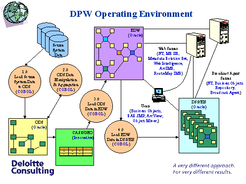
Figure 4: DPW
Operating Environment Diagram
Enterprise Data Warehouse
Integration:
Deloitte Consulting’s approach to GIS is evolving with
the creation of Enterprise Data Warehouses. Data Warehouses lend themselves well
to GIS and Deloitte Consulting found that State clients naturally progressed to
a maturity level where they were comfortable with their warehouse and willing to
view data in maps. However, Deloitte Consulting does not feel that State
governments are compelled to develop an entire Data Warehouse to pursue their
GIS efforts. Essentially, any State agency that has a centralized repository of
spatial data can implement E-Government GIS solutions.
Integration with the EDW serves as a major boost to GIS
development at the DPW. The EDW establishes the initial standards on data
quality from every program office that requests a map. These standards reduce
the effort on the part of the GIS team to secure data and verify that the
information is correct. Two components of the EDW environment lend to a reduced
time frame in creating GIS solutions to business questions. These two components
combine to generate all the data necessary for developing a mapping solution.
The first component is the Development-Production environment currently existing
at the DPW. The second component is the user workgroups developed for each
Program Office at DPW.
Current Environment:
The Department of Public Welfare’s current environment
includes two logical areas developed through the necessity based on the
requirements of their enterprise data warehouse. Similarly, this environment is
applicable to the services that will be developed from GIS tools. These two
functional areas are the "Development" and "Production" areas. Essentially, the
two areas are the same in terms of logical structure, however their purposes
have slight contrasts. Figure X depicts the interaction between the functional
areas and the user workgroups.
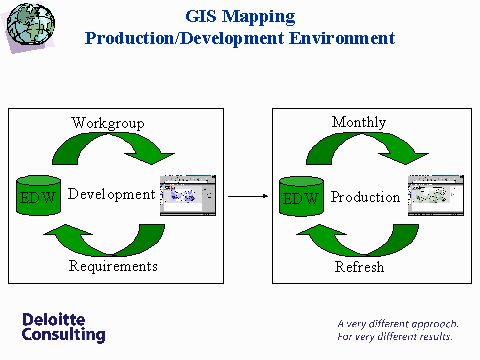
Figure 5: GIS
Mapping Production/Development Environment
The Development area exists to test all data and
applications before moving that system to Production. The GIS Development area
begins with a request from the user workgroup. The requirements derived from
that request are implemented in a "test" map located on a Development area
server. Workgroup users have access to this server and begin their interaction
with the GIS tool.
When the users and the GIS team finalize all their
requirements and validate the data included in the map, the application is
migrated to the GIS Production area. The Production area is located on a
different server than the Development area and each map is automatically
refreshed with the most current data on a set time frame. All users have access
to the GIS Production maps.
User
Workgroups:
One of the first components of the Data Warehouse
environment is the user group. User workgroups meet with the Data Warehousing
team and request that data be entered into the warehouse. User workgroups also
request services from the Data Warehousing team including cubes, reports, and
maps. These services allow the users to access their information from the
warehouse in a useful form and fashion.
The user workgroups meet with the warehouse staff and
determine data requirements. This process defines various amounts of information
including data types, table size, access speed requirements, and data source
location. Often, the requirements gathering process is iterative and can last an
extended period depending on the amount of information in question.
After determining the data requirements the Deloitte
Consulting staff on the warehouse project will use the Informatica
Powermartâ software to develop
transformation logic. Transformation logic essentially defines a process of
creating the data source, any data transformations, and data target locations.
The warehouse team refers to this as the Extraction, Transformation, and Loading
process or ETL. The ETL process for any given user group should clearly and
accurately place the users data and requirements into the warehouse.
After information is added to the warehouse the GIS
developer has the responsibility of transposing the information to a map.
Deloitte Consulting uses the data provided by Esri on the county level in
Pennsylvania as a starting point for shape file creation. The original outline
of the State of Pennsylvania is used while determining the data that will enter
the map. This information is relayed from the user requirements meetings.
ArcView scripts are created on the GIS Webmaster’s machine with the SQL connect
extension that allows the ArcView script to communicate through an ODBC to the
Oracle 8i Data Warehouse. The Oracle 8i client must be installed on the client
machine in order to ensure that the connection works correctly.
The script then calls a login to the database and runs a
SQL query from the table source created by the ETL process mentioned above. The
script will then join the information from the table in the warehouse to a
temporary table in the ArcView project. The script will begin to create new
fields in the shape file and calculate the values for those new fields based on
the values in the joined fields. This effectively refreshes the map for a
specific month based on the table in the warehouse. When the calculation in
complete the script removes the join and saves the
project.
Geocoding Software Integration:
An essential portion of integrating GIS into the Public
Sector is the use of geocoding software to maximize the effectiveness of stored
address information in the warehouse or another central information repository.
Integration of the geocoding software into the Enterprise Data Warehouse
operating environment involves individuals that understand the data as well as
the proper tools to geocode address information. The DPW team implemented the
following strategy for maintaining the accuracy of geocoded address data
elements:
HOUSE NUMBER – required information
STREET NUMBER – required information
STREET NAME – required information
ZIP CODE – required information
ZIP+ 4 – relaxed data
Needs
Assessment:
While providing mapping solutions to the Office of
Mental Retardation (OMR) of DPW, the consulting team experienced first hand the
difficulties involved in developing accurate point thematic maps while using zip
code data on HMO addresses. All geocoded points stacked up at the centroid
location of the zip code polygon. It became clear that a more accurate geocoding
software tool was required such that it will perform the geocoding operation on
the actual street address and not be limited to the use of a zip code or the zip
+ 4 data.
Further more, it became clear that address data and
attribute information from several program offices (OMR, OCYFS, and OIM) such as
licensing facilities, HMO’s, and day-care centers had considerable inaccuracies.
These inaccuracies included misspellings, variations in identifying different
entities (Medicaid recipients, Day Care Centers, HMO provider addresses and
corresponding recipient data), and incorrect information.
Welfare data on recipients and providers stored in the
Data Warehouse archives activities related to disbursement funds. Increasingly,
the Department of Public Welfare (DPW) wished to determine the distribution of
State and Federal funds for these recipients and providers. The addresses for
both the recipient and the provider generate from different program offices, yet
this information alone is insufficient to pinpoint exact locations of these
parties.
The geocoding software by INNOVATIVE SYSTEMS, Inc.
called Innovative Dictionary System was primarily being used for accurately
identifying recipients, licensing facilities and managed care organizations
through verification, matching, standardization, and geocoding of their
addresses in spite of errors, misspellings, and variations.
Innovative Dictionary System was selected by DPW as the
preferred software due to its strong address geocoding and standardizing
capabilities. Approximately 6,000 childcare facilities in PA were address
matched and geocoded with an accuracy of more than 89% match during the
demonstration for DPW. In addition, this geocoding software allowed easy
inter-operatibility between UNIX and NT platforms.
Necessary
Features of Geocoding Systems:
|
Enhanced Knowledge Base |
|
Processing capabilities should be based on a
proprietary knowledge repository of more than 2.5-million name and
address-related words, and more than 100,000 word
patterns. |
|
Accept Any Fixed-Length Input
Record
|
|
The Innovative Dictionary System offers the
flexibility to process a wide variety of customer record
formats. |
|
Allow User-Defined Error And Review
Codes |
|
The Innovative-Dictionary System enables you to
pre-select a series of data conditions to be flagged as errors, or
requiring further review. These records can then be automatically
processed through the Innovative-Review™ Productivity
Tool. |
|
GUI Setup Wizard |
|
The Innovative-Dictionary System's GUI Setup
Wizard, with helpful descriptions of all dictionary options, makes it easy
to tailor the system's parameters and error flags to your needs. It
includes a test parser, as well as interfaces to the Innovative-Review
Productivity Tool. |
|
Address Standardization |
|
The process by which the address in a record
corrected to meet specific pre-defined formats that is structured around
the user needs, USPS carrier route codes and naming conventions for street
and house number. |
|
Address Matching |
|
The process where the input/raw address data is
compared with the USPS standard address ranges for that particular address
record. Verifying the existence of an address with numbers and names to
the corresponding exact numbers and names for a particular address makes
the match. |
|
Address Geocoding |
|
The process by which addresses are assigned a
Latitude and Longitude value corresponding to their actual location on a
map. |
|
Software Capabilities |
Observations |
|
Address Scrubbing |
100% |
|
Modularity |
The address matching, geocoding components can be
broken up into separate modules and installed on different platforms or
computers |
|
Streamline process |
Process – from Delivery of address tables to the
Data Warehouse as extracts, to the complete geocoded tables in the ORACLE
Warehouse with address standardization |
|
Address Geocoding |
89% of addresses were geocoded |
|
ZIP + 4 Capabilities |
Geocoding of address records at the ZIP +4 level
was handled well |
|
Online/Batch processing |
Geocoding capabilities can be extend to a batch
process or as an online method |
|
Integration |
The software allows easy integration with existing
hardware and software platforms. |
|
API Customization |
Customizable application interfaces allows
different data capture applications developed as front-end
tools. |
Selection Criteria and
Assessment:
Observations:
The geocoding accuracy of address data elements improved
with more restrictive conditions/criteria as seen from these results. As a
result of this analysis it was decided by the GIS team that all program offices
had to have their data corrected and standardized once for all by using the
geocoding procedure outlined earlier thus accurately identified the
corresponding address data elements of recipients, providers and licensing
facilities. The geocoded data sets were then used for developing customized maps
in ARCIMS and RouteMap IMS applications.
The results of the geocoding process are shown below
when House number, street name, and zip code were relaxed. Only 16% did not
match in this case.

Figure 6: Geocoding Results with
Relaxed Conditions
The next result set of the geocoding process show when
House number, street name, and zip code fields are required. Here, 38% did not
match.
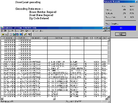
Figure 7:
Geocoding Results without Relaxed Conditions
Maps
Developed:
Childcare
Providers in ArcIMS:
The first map described in this paper is the Childcare
provider map. The Office of Income Maintenance attended their user group meeting
and approached Deloitte Consulting with the task of developing a map that
displayed the relative concentrations of Childcare providers in a County view
and a Zip code view, while providing the address of these providers as
additional information. The GIS development team determined that the views were
possible in the same map as scale dependent layers and that ASP pages could be
utilized to extract the addresses directly from the warehouse. Set upon the
task, the development team began piecing together the location of the data in
the warehouse from the workgroup.
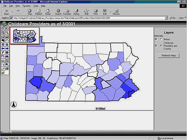
Figure 8:
Childcare Providers ArcIMS Application County Zoom Level
The completed map is represented above in figure X. The
map utilizes the default window formatting of ArcIMS as a starting point. The
intent is that the GIS team will slowly transition the State government users
over to GIS usage since they had no previous experience. After a maturing
process the users will begin to see a more customized map with the Departments
logos and other amenities.
A few of the functional uses for this map are the dark
outline indicating service areas, color gradation eliciting density of
providers, hyperlinking functions, and querying functions. The dark outline
represents a requirement of the user workgroup. Often, State governments will
designate "areas" or "zones" to target enforcement of policies or measure
performance for programs. Childcare falls into one of these categories of Human
Services and Pennsylvania is easily broken into major areas of monitoring. The
greatest distributions of people in the state exist in two counties, namely
Allegheny and Philadelphia counties where the cities of Pittsburgh and
Philadelphia exist, as seen in the darkest shadings on the map in figure X. The
outlines in the map show the conceptual boundaries of these areas as the State
views them. The color gradation was discussed above.
Also, built into the map is a scale dependent layer that
changes the view of the map when zoomed closer to an area of interest. In the
Childcare Providers map the zip code view is scale dependent and becomes visible
when the user zooms into a county. In figure X below, the concentration of
Childcare Providers is shown for the Zip Code level. The functional use of the
map is similar for the County Zoom Level and the Zip Code Zoom
Level.
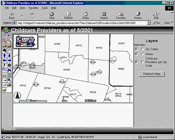
Figure 9:
Childcare Providers ArcIMS Application Zip Code Zoom Level
The hyperlinks built into the map are direct links to an
ASP page on the server that returns the childcare provider information for the
county selected. The shapefile on which the map is built contains this link for
every county. The hyperlink button on the map merely takes that link and calls
the ASP on a new page. The data retrieved by this link comes directly from the
warehouse. The resultant information is displayed in the format as given in
figure X, below.
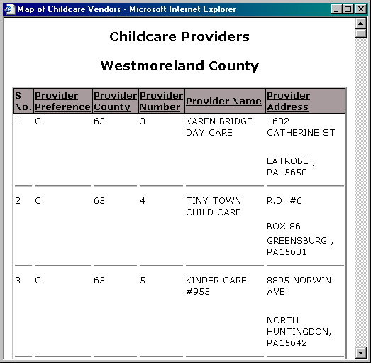
Figure 10:
Supplemental Childcare Providers County Hyperlink Report in
ArcIMS
This result set serves a few services to the map users.
First, this result allows users to retrieve address information for constituents
in the event that clients request that type of data. Second, State workers are
often asked for mailing labels by several sources in order to elicit responses
from registered childcare providers. This page allows State employees to quickly
produce that information. Thirdly, this information can be plotted on another
map and used to compare the client’s address to the address of the provider on
the map.
Similarly, a Zip Code Level Hyperlink Report is
available when users zoom to the Zip Code level and make the Zip Code Layer
active. Where the above report lists the Childcare Providers by a user selected
County, the report shown in figure X below shows Childcare Providers for a
selected Zip Code.
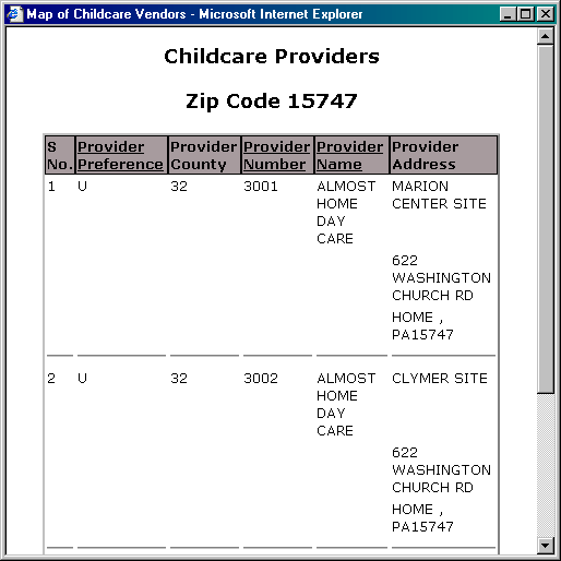
Figure 11:
Supplemental Childcare Providers Zip Code Hyperlink Report in
ArcIMS
Employment
and Training Programs in ArcIMS:
The second map described in this paper is the Employment
and Training Program (ETP) map. After presentation of the Childcare Provider
map, OIM approached Deloitte Consulting with the ETP project. Similar to the
Childcare Providers map, the ETP project was concerned with the location of
several sites across the State of Pennsylvania. The proposed ETP map would
display the relative concentrations of ETP sites in a County view while
providing the address of these providers as additional information. The GIS
development team determined that ASP pages could be utilized to extract the
addresses directly from the warehouse.
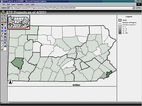
Figure 12:
Employment and Training Program ArcIMS Application
The completed map is represented above in figure X. The
map utilizes the default window formatting of ArcIMS as a starting point. A few
of the functional uses for this map are the dark outline indicating service
areas, color gradation eliciting density of providers, hyperlinking functions,
and querying functions. The dark outline represents a requirement of the user
workgroup. The greatest distributions of people in the state exist in two
counties, namely Allegheny and Philadelphia counties where the cities of
Pittsburgh and Philadelphia exist, as seen in the darkest shadings on the map in
figure X. The outlines in the map show the conceptual boundaries of these areas
as the State views them. The color gradation was discussed above.
The hyperlinks built into the map are direct links to an
ASP page on the server that returns the employment and training program
information for the county selected. The shapefile on which the map is built
contains this link for every county. The hyperlink button on the map merely
takes that link and calls the ASP on a new page. The data retrieved by this link
comes directly from the warehouse. The resultant information is displayed in the
format as given in figure X, below.
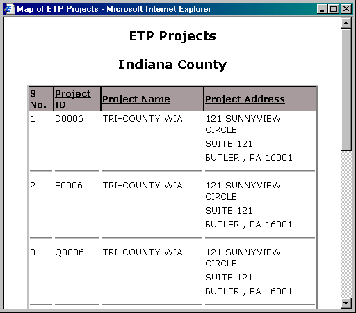
Figure 13:
Supplemental ETP County Hyperlink Report in ArcIMS
Personal Care
Homes in RouteMap IMS:
The third map described in this paper is Personal Care
Homes (PCH) map. The PCH Map represents DPWs maturity in utilizing GIS tools.
Similar to the Childcare Providers and ETP map, the PCH project is concerned
with the location of several sites across the State of Pennsylvania. The
proposed PCH map would display the relative locations of PCH sites across the
State. However, the PCH map utilizes two new technologies incorporated to the
EDW environment.
The first technology is the Geocoding Software that
accepts the address information for Personal Care Homes in the State as input
and outputs the geocoded location of the data. The second technology is RouteMap
IMS as a mapping tool. RouteMap provides a standard view of data on a map, an
ability to find the address and locations of certain data points on the map, and
the ability to route between these data points and other addresses on the
map.
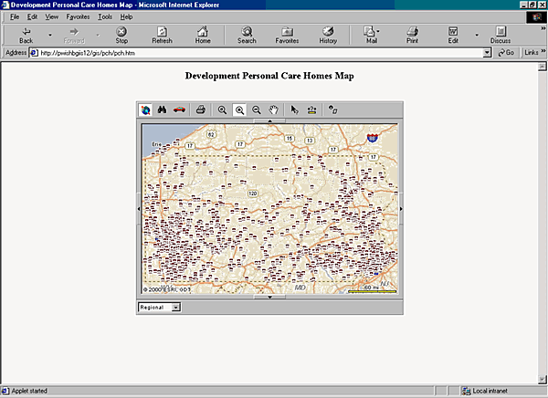
Figure 14: Personal Care Homes Initial
Map View () in RouteMap IMS
The initial map view shows the user any information
added to the map and a general area of interest. In figure X above, the State of
Pennsylvania is shown with several locations labeled with an icon. In this view
users can print the shown map ( ), zoom to the fullest extent
of the map (
), zoom to the fullest extent
of the map ( ), zoom into a particular area (
 ),
zoom out of a particular area (
),
zoom out of a particular area ( ), pan the screen to another
area (
), pan the screen to another
area ( ), identify one of the features on the map (
 ), measure the distance between two objects (
 ), and select any number of items on the map
[retrieving their information] (
), and select any number of items on the map
[retrieving their information] ( ).
).
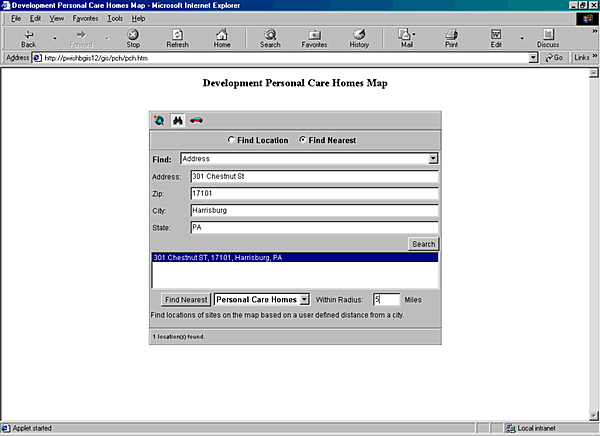
Figure 15: Personal Care Homes Find
Feature () in RouteMap IMS
The Find view shown in figure X allows the user to
search for a particular address on the map and any data points located within a
specified distance to the user’s address. There are two screens on the find
view. The first view is a ‘Find Nearest’ function with the functionality
described above. The second screen allows the user to find a specific address
and place that address on the map.
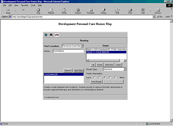
Figure 16: Personal Care Homes Route
Feature () in RouteMap IMS
The Route view shown in figure X allows the user to
input addresses into the form and find the Quickest or Shortest routes between
the addresses. A user may enter multiple addresses at one time and also may
search for other data points added to the map. In the PCH map the user can
search and add a start address, then search and add a PCH address, then search
and add another address, and possibly search and add another PCH address. Next,
the user can press the ‘Find Route’ button and the map will return a mapped
route to take with the written directions.
ETP and
Childcare Providers in RouteMap IMS:
The fourth map described in this paper is the ETP and
Childcare Providers RouteMap IMS map. With the release of the newest version of
RouteMap IMS came advancement in the capability of Health and Human Services
mapping solutions. As seen in previous maps, ETP and Childcare Provider data
were displayed in relative concentrations to their county or zip code, while
links returned the actual addresses for those providers. Members of the user
workgroup were anxious to give users in the community the ability to find the
locations of these sites relative to their own address. RouteMap IMS 2.0 allows
the capability to enter your own address as a start location, but also map a
route to multiple stops from different geocoded data sets.
The ETP and Childcare Providers map gives Internet users
(not only DPW Intranet users), the ability to locate their own address as well
as the route, distance, time, and directions to multiple ETP sites and Childcare
facilities. Also, the GIS Team began to experiment with customization of the
RouteMap user interface because the team felt the user workgroups and GIS user
population were maturing in their use of maps. The ETP and Childcare Providers
map gives a customized view of the information, while retaining all the
functionality of the previous maps.
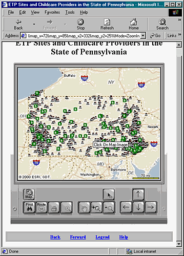
Figure 17:
ETP and Childcare Providers Map Customized in RouteMap
IMS
Office of
Income Maintenance Philadelphia Information Map in
ArcIMS:
The fifth map described in this paper is the OIM
Philadelphia Information map. After the GIS Team developed the Childcare
Providers map and the ETP Projects map, OIM users began to mature in their
general GIS knowledge and use. On recommendation of the users, the GIS Team was
asked to develop a map based on the welfare reimbursement programs of Cash, Food
Stamps, and Medical Assistance. Each of these programs contains several
sub-categories of information that define the distribution of welfare to
recipients in the State of Pennsylvania.
The proposed map for OIM would display one the three
programs with the user having the ability to change the measures on the map. The
first map, shown in Figure 18 below shows the layout for Philadelphia County. In
meeting with the user group and gathering requirements, the user group decided
that two views of the data were necessary for the creation of this map. The
views are explained in greater detail below.
The initial screen gives the user a choice of data
views. On the left of the screen is a pull-down menu that allows the user to
choose the view they desire; either Administrative District or Zip Code.
Philadelphia County is the only view available so far, because of a large data
migration issue. The workgroup decided that an initial view of Philadelphia
would be beneficial until the GIS Team could resolve the data
issue.
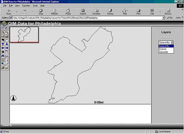
Figure 18:
OIM Philadelphia Information ArcIMS Application
The first view is Administrative Districts as defined by
OIM. The shapefile created for this view was developed from the initial zip code
shape file on the Esri data CD. Initially, the Administrative Districts were
only shown on paper and the shapefile used above needed to be developed.
This view contains three layers to view information
based on the program the user wishes to view; Cash, Food Stamps, or Medical
Assistance. On every layer there are five measures that change the relative
concentrations for the associated Districts in Philadelphia County. These
measures are the Number of Cases, the Number of Budgets, the Number of
Recipients, the Benefit Issuances, and the Benefit Amount. This view is shown in
Figure 19, below.
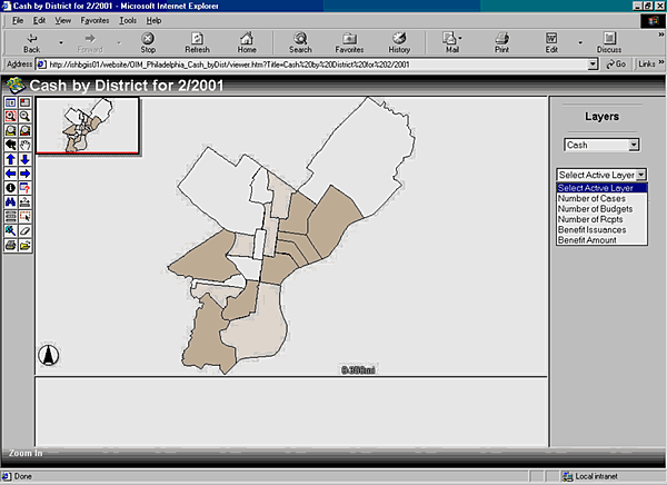
Figure 19: OIM Philadelphia
Information District Map by Cash
The second view is Zip Code view of the same area,
namely Philadelphia County. The shapefile created for this view was taken from
the zip code shape file on the Esri data CD. This view contains the same three
layers as the Administrative Districts view and users can view information based
on the program they wish; Cash, Food Stamps, or Medical Assistance. On every
layer there are five measures that change the relative concentrations for the
associated Zip Code in Philadelphia County. These measures are the Number of
Cases, the Number of Budgets, the Number of Recipients, the Benefit Issuances,
and the Benefit Amount. This view is shown in Figure 20, below.
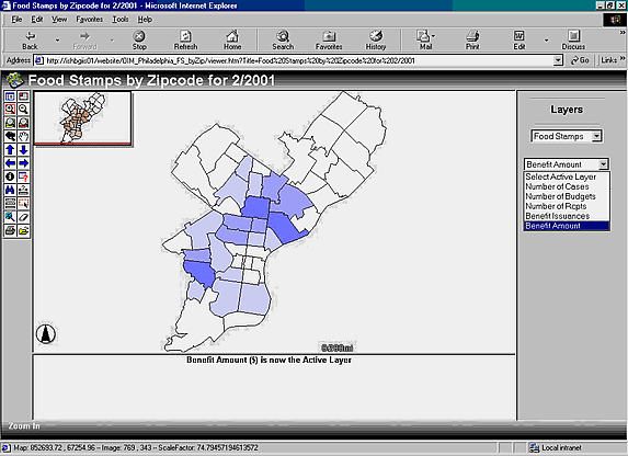
Figure 20:
OIM Philadelphia Information Zip Code Map by Food Stamps
Documentation:
Documentation is an essential component of the EDW
E-government GIS tools. Accompanying the creation of every map are five
documents that describe the steps taken to create that map. The documents
developed include the Data Extraction Procedures, the Metadata Development, the
Customization Documentation, the User Refresh Manual, and the Website Flow
Diagram. The development of Documentation serves two main purposes for the
Department of Public Welfare. These purposes include the ability to recreate a
mapping solution in the event that the map is lost from the system and the
transfer of knowledge from Deloitte Consulting practitioners to the client.
Portal
Implementation:
The final phase in the creation of e-government
solutions coupled with GIS technology is the implementation of a portal. Portals
are traditionally defined as information delivery pages or websites. The portal
perpetuates the dissemination of information regardless of format or type and
integrates this data from multiple sources. Of course, there are many systems
that allow for the integration of data, however, portals serve as a ‘one-stop’
delivery mechanism over a system independent medium; the Internet. The strength
of a portal lies in the comprehensive integration of all the components in its
delivery systems. This includes tools, applications, contents, and other
interface features presented on the website.
The most poignant examples of portals in the marketplace
are Excite, Yahoo, CNN, or MsNBC. Information from different sources on weather,
news, stocks, and consumer products is accessible through a single location
tailored to the users’ needs. Comparably, integrated search engines allow these
portals to connect to more information sources in a seamless process, thus
extending the users’ access from a single location. In the case of GeoSpatial
portals such as GISCafe, Geocommunity, or TenLink, information portrayed to
users is specific to the GIS industry. These portals include information on data
sources, on white papers, on employment, on business news, and on many other
areas.
However, portal technology depends heavily on the
ability to traffic data into your website so users can use your applications.
Accessing, retrieving, and displaying data over a GIS portal is even more
dependent on the transfer of data from multiple sources in multiple formats. A
technology has emerged in the marketplace that allows an efficient processing
and storing of data, usable in all GIS tools. The eXtensible Markup Language
(XML) is becoming the foundation for data transfer over the web, including
applications in e-commerce. XML allows an organizations to defines the format
and type of data they receive/transmit over a common connection while parsers
associated with XML allow organizations to process data they receive.
Esri has taken a lead in adapting this technology to
their current products. ArcIMS already possesses XML processing capabilities; in
fact it is the heart of their current Internet Mapping Server software. AXL
files are the Arc eXtensible Language files that describe the shapefiles used in
an ArcIMS mapping. These files use properly coded XML tags to define all aspects
of a shapefile and parts of its presentation including ramping color, ramping
ranges, shapefile location, shapefile fields used, and much more. This link from
ArcIMS to XML is the ridge that allows data to be taken from a source to a
mapping to a portal.
Currently, E-government portals relay information about
government business, including local town meetings, Department of Motor Vehicles
Licensing forms, Internal Revenue Service taxing districts, and the proceedings
of the last meeting of Congress. However, these portals could include urban
planning maps, zoning regulation maps, location and direction to Childcare
Providers in your area, concentration of Health Maintenance Organizations (HMOs)
across your State, and much more. Portals will also include further interactive
components that allow citizens to pay taxes, collect information on
unemployment, and provide feedback to their local or state government entities.
However, E-government portals with GIS components allow the dissemination of
spatial information in addition to more common textual/content information. Maps
provide a strong visual approach in providing effective information.
After carefully examining the mapping needs of different
Program offices like the OCYFS, OMR, and OIM, it became clear to the GIS team to
define and design the GIS portal for the Pennsylvania Department of Public
Welfare that would encompass all the unique information delivery requirement of
the different program offices.
OCYFS was primarily concerned in identifying day-care
centers, licensing facilities such as retirement and nursing homes in order to
determine optimum routes to and from a facility. The RouteMap application
software would have to be integrated for this purpose within the portal. On the
other hand, OIM spatial data requirement meant display through polygon thematic
maps information on the disbursement of welfare funds by County and Region. OMR
(Office of Mental Retardation) required maps that provided a percentage count on
medical provides by region and county with the Commonwealth of Pennsylvania.
Both these mapping applications required ArcIMS incorporation within the
Portal.
The design of the portal would include assigning unique
id (Identification Numbers - based on type of mapping project request and the
Program Office) for each of the different program offices and making the data
readily available after request are made through the use of DPSR (Data
Processing Service Request). The DPSR forms would also be an integral part of
this GIS portal, shown in Figure X below. Thus users from the respective Program
Office’s will be able access their maps (created in either ArcIMS or RouteMap
IMS) for any kind of data analysis, statistical evaluations, or preparing a
general report. These reports could be created using different parameters and
different spatial references (at the Regional, the County, or the State
level).
Figure 21:
Portal Implementation for Offices at the Department of Public
Welfare
Benefits:
The GIS Portal implementation Strategy for DPW has been
a beneficial undertaking both for the managing project partners (Deloitte
Consulting DPW staff and Independent Consultants) as it has allowed easy access
to real and historical information from the Enterprise Data Warehouse. The
‘One-Stop’ Information Delivery page as part of the E-government GIS solution
allows more than one program office to access information on more than one
dimension about its business data (related to welfare) from the Warehouse
simultaneously. Besides, historical data, current information by Region, County,
City, or State can also be presented in a map.
Furthermore, the extension of some maps to the general
public benefits the constituents of the State of Pennsylvania. Particularly in
the RouteMap IMS maps, we see viable portal applications that large communities
of users can access. The demand for these applications is evident when
considering the surge of the Internet and the current websites developed by the
Office of Occupational and Labor Market Information, Delaware Department of
Labor.
Conclusion:
It is justifiable to believe that as more and more
services are offered to the citizens by Local, State, and Federal government
agencies, the need for the analysis and the evaluation of geographically related
data will require some form of mapping solution. Most likely the delivery of
spatial information that can be shared both internally within government
agencies and externally with the population at large will be done via the
Internet. Designing and developing GIS Portals will constitute an integral part
of the total E-government solution.
References:
Greene, R. W., (2001). Open
Access: GIS in e-Government. California, Esri Press.
Harder, Christian, (1998). Serving Maps on the Internet:
Geographic Information on the World Wide Web. California, Esri Press.
GeoMAC Wildland Fire Support
Retrieved June 11, 2001 from the World Wide
Web:
http://wildfire.usgs.gov
The Office of Occupational and Labor Market Information,
Delaware Department of Labor
Retrieved June 11, 2001 from the World Wide
Web:
http://www.oolmi.net/Career_Directions.asp
The Federal Geographic Data Committee
Retrieved June 21, 2001 from the World Wide
Web:
http://fgdc.gov/
Pennsylvania Spatial Data Access
Retrieved June 21, 2001 from the World Wide
Web:
http://www.pasda.psu.edu/
The Pennsylvania Geospatial Information Council
Retrieved June 21, 2001 from the World Wide
Web:
http://www.pagic.psu.edu/
Waxman, Andrew, (2000, January). Esri ArcIMS 3.0 – An
Application Developer’s Perspective.
Retrieved February 21, 2001 from the World Wide
Web:
http://spatialnews.geocomm.com/newsletter/2000/22/arcims.html
State Service Commission, Govt of New Zealand, New
Zealand E-government Programme – Structure.
Retrieved May 19, 2001 from the World Wide
Web:
http://www.e-government.govt.nz/context/structure.html
Korzeniowski, Paul (2000) The
XML Factor, Federal Computer Week
Retrieved May 20, 2001 from the World Wide
Web:
http://www.fcw.com/supplements/B2G/2000/b2g-factor-08-28-00.asp
Langlois, Greg (2001) Map
Migrations: Geography Markup Language takes advantage of XML’s, Federal
Computer Week
Retrieved May 20, 2001 from the World Wide
Web:
http://fcw.com/fcw/articles/2001/0423/tec-map-o4-2301.asp
Natoli, James (1997), Geographic
Information Systems; The wave of the future for Information Analysis - New
York State Office of Technology
Retrieved May 19, 2001 from the World Wide
Web:
http://www.oft.state.ny.us/policy/tp_9618.htm