Generalization of Multiple Scale Maps from a Single Master Database
Miguel Garriga, Geoff Baldwin
Abstract: This paper describes some of the work being
done on map generalization at the American Automobile Association (AAA).
AAA produces various map products at different scales for our members,
including detailed city maps, vicinity maps, regional maps, and atlases.
Our goal is to maintain all of the required geographic data in a single
master database and to generate all of our map products from this one database.
A closely related goal is make updates only once, directly to the master
database, and to have those changes automatically appear in all derived
maps the next time they are produced.
Introduction
This paper describes map generalization as it is being practiced
at the American Automobile Association (AAA) for production of maps at
various scales. We use both UNIX Arcinfo and the newer ArcGIS 8.1 desktop
software for the NT. The main focus of this paper is Automated Extraction,
the technique we use to pre-select which features should appear on a particular
map product.
This paper is an update to a presentation given at the
1998 Esri User Conference, "Producing Multiple Scale Maps from a
Single Master Database" , available online at: http://www.Esri.com/library/userconf/proc98/PROCEED/TO350/PAP327/P327.HTM.
That paper described AAA's approach to map generalization at the start
of our GIS map development effort. This update describes some of the changes
in our generalization philosophy, and what our current thinking is for
the future of map generalization at AAA.
Objectives for GIS Map Production - Mission Statements
GIS was brought to AAA with the following expectations and
objectives:
-
Create a seamless, nationwide master database to support
all map production needs
-
Produce multiple map products from a single master database
-
Update features only in master database, synchronize changes
to all map products
-
Cartographic edits only on map products, not the master database
-
Yearly updates to map products will be able to re-use last
year's work, and also include all changes to the master database that might
affect a given map product.
-
Support electronic travel-related products, such as the Internet
Triptik.
Other organizations using GIS for Cartography may share some
or all of these goals. Individually, these goals seem logical and workable.
No one objective seems that difficult, but taken together they form quite
a challenge.
Ideal - Live Generalization of product from master database
An ideal generalization solution for AAA would be one where
the master database contains detailed data and all map products are "live"
views into that data. All generalization would occur on the fly, with no
duplication of data. The system would not create new generalized datasets,
but would make on the fly display calculations to display features from
the master database according to specific rules for the desired map product.
The map would be a specialized way of looking at the master data, without
actually containing data.
To summarize, an ideal generalization environment for
us would be as follows:
-
The source data would be stored in a seamless nationwide
(worldwide?) database such as SDE
-
A map could be generalized on the fly, in real time, in its
own projection with minimal interactive work required.
-
There would be no duplication of data. The map would consist
of features from the master database, generalized in real time to enhance
their appearance or behavior on the map.
-
The user would be able to make adjustments to the output
of generalization to add, remove, or otherwise change the appearance of
objects as needed.
So far we have not been able to achieve this ideal of live
generalization. We have also not been able to create map products without
duplicating data. The duplication of data is an issue for us mainly because
duplicating features complicates the update of the master database and
derived products. The scenario we want to get away from is where a change
needs to be made to every individual map product a feature appears in.
We would rather make the change only once, in the master layer, and have
that change appear on all derived map products, including maps on a regular
maintenance cycle.
We find that it is extremely difficult to create maps
in different scales and projections directly out of the master database
without duplicating data. At least we have not found a way to do it that
works for a wide range of scales. Someday processing speeds and new functionality
will allow us to achieve this goal of not duplicating data. In the meantime,
we will have to develop a synchronization program to propagate changes
that are made at the master level to all of the relevant product layers.
Evolution of our Approach to Generalization
Our map production procedures are a set of compromises that
we have reached between our desire to have a single master database, our
technical abilities, and performance of the software and hardware we use
to do our work. Since we cannot generalize the master database on the fly,
we compromise and create map-specific datasets as the output of generalization.
This potentially complicates update scenarios, but this compromise is necessary
in order to meet our map production schedules.
From ArcStorm Visibility files to SDE Product Layers
The visibility file concept is the closest we have come to
not duplicating data for map products. When we started making maps with
the GIS, we avoided duplicating data by using "visibility files" - INFO
files containing unique feature IDs, which we used to create Arcplot selection
sets (WRITESELECT and READSELECT) to control which features appeared on
a map product. A single product layer per map was created to hold all features
that needed to be displaced or altered in some way from their default properties
in the master database. Each individual map view was projected on the fly
using MAPPROJECTION, from the master projection in Albers to the specific
product's projection and parameters.
The performance of selection sets and Mapprojection under
ArcStorm was tolerable with UNIX Arcinfo 7.2.1. When we switched to Informix
SDE and UNIX Arcinfo 8.0, Mapprojection's performance was noticeably slower,
and deemed unacceptable by our cartographers and developers alike. We decided
to shift our approach to generalization.
In order to improve the performance of the system with
SDE, we did away with the old Visibility files and Mapprojection. Instead,
we took the visibility file concept a step further. The visibility files
used to be plain INFO files with one column - the unique ID of each feature
in a map product. That was all we needed to keep track of which features
in the master database should appear on a particular product. We decided
to add a shape column, essentially turning the visibility file into a coverage
or shapefile. Since we now had an actual coverage we could manipulate,
we applied the product projection directly to the extracted data, doing
away with the Mapprojection command, and this improved performance tremendously.
What we ended up with, instead of visibility files, was
product layers in SDE for each map product. Cartographic displacements
and other generalization processing could be done directly on the product
layers. We decided to keep all attribution on the master database only,
in order to prevent users from accidentally making master-level changes
to the product layers.
Right now, product layers are just the shape, a unique
id, and a symbol item; not much different than a CAD file. We are giving
some thought to leaving the full attribution on them. This would give us
greater flexibility and control over the appearance of features in a map
product. Another advantage subsequent map revisions would be able to see
exactly what was on the old map, including underlying attributes. We are
still debating the merits of this change. The concern is that it will be
difficult to coordinate edits to the master and product layers. We would
have to develop some sort of synchronization program to propagate changes
from the master database down to the product layers.
Ramping up to Generalization
Our approach to generalization has been gradual. Our source
database is highly detailed, street level data from Navigation Technologies
(NavTech) and Geographic Data Technologies (GDT), along with value-added
AAA features and attribution. Generalization issues increase in complexity
the further you get from the source data's scale or resolution. With some
exceptions, we have approached generalization by starting with large scale
maps that are closer to the source scale of the data, and over time have
progressed to smaller scale maps.
Our first prototypes using GIS software (UNIX Arcinfo)
were the Alabama/Georgia State maps, and the Atlanta CitiMap. Based on
these early prototypes, we decided to focus our development efforts on
creating a system for CitiMap production. The principal advantage of doing
this was that CitiMaps were much closer to our source data scale, and therefore
had fewer generalization issues. We used nearly all of the features in
our source database for the city scale maps. Our generalization needs consisted
of:
-
Centerlines - Creating a centerline network out of divided
roads, such as Interstates, which are digitized in both directions of travel.
-
Weeding out features of interest (FOIs). Initially this was
done manually, but we now have Automated Extraction routines to pre-select
layers for each map type.
-
Maplex for Text Placement.
-
Displacing features as needed to ensure that they do not
obscure each other. This is similar to the problem of text placement -
accommodating lots of information on a map, preserving spatial relationships,
yet moving things around a bit to better accommodate all the information.
Centerline Layer
Our data sources provide us with very detailed, high quality
data. Interstates and other divided roads are digitized as separate arcs
in each direction of travel. At most map scales, we represent divided highways
with a single line symbol. We only show both directions of travel with
separate linework on our downtown insets. Since the vendor provides doubly
digitized arcs, not centerlines, we had to create the centerlines.
Although Arcinfo now has a CENTERLINE command which will
create centerlines out of separately digitized directions of travel, this
command was not available when we created our centerline layer. We contracted
this work out, and received a centerline layer that required some interactive
cleanup work. Most of the cleanup was at intersections, where centerlines
sometimes went astray. Also, we did considerable work to create ramp extensions,
so that existing rampwork would hook up to the new centerlines.
I want to emphasize that we did not use Arcinfo's CENTERLINE
command, so these comments about cleanup may not be applicable to the CENTERLINE
command.
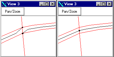 |
Figure 1. Fixing collapsed roads
at intersections |
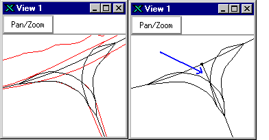 |
Figure 2. "T"-ing
off intersections where doubly digitized roads meet |
 |
Figure 3. Extending Rampwork (1,2)
to meet up with centerlines (3, 4) |
Automated Extraction (Pre-selection)
Feature Matrix
At the start of the GIS project, a lot of effort was put
into examining our existing map products and tracking what types of features
went into each of the different products that we make. The result of this
effort was the Feature Matrix, which lists individual feature types (roads,
national parks, etc,) as rows and individual map inset types as the columns.
An 'X' in a cell indicated that a feature did appear on that map product.
In the early part of GIS map production, before automated Extraction, we
relied on the Feature Matrix, essentially using the matrix to determine
what features to manually extract from the database for each new GIS map
product.
Turning the Feature Matrix into Extraction Rules
The Feature Matrix was the starting point for Automated Extraction.
Although the matrix told us if a feature appeared on a product, it did
not tell us all the parameters we would need to determine if a feature
should appear on an inset. For example, a state map product includes lakes,
but only lakes larger than a certain area, and that cutoff size is probably
related to the scale of the map product, and what type of information that
product is supposed to convey. So the next step for us was to develop extraction
rules, elaborating on the basic information in the matrix, and specifying
any parameters needed for inclusion in a product.
One of our senior cartographers was a key member in developing
the Feature Matrix, and took on the task of writing the precise Extraction
Rules. Because he helped develop the matrix, he had a good understanding
of the logic behind why features occur on each map type.
We wrote the extraction rules in pseudo code, in such
a way that a programmer could easily write code from it in whichever platform
we ended up using (UNIX or NT). As a result of this effort, we created
one set of "Extraction Rules" for each map series. Each set of documents
listed all the extraction logic for up to 7 possible inset types per map,
for each of 11 possible GIS layers.
Turning the Extraction Rules into Program Code
We coded Extraction Rules in AML because the performance
for this type of SDE attribute selection logic was faster with UNIX Arcinfo
than with ArcMap desktop, at least during the Beta test period. Now that
Arcinfo 8.1 is final, we will revisit our approach and re-evaluate selection
performance on the desktop.
During this coding phase, a programmer took the cartographer's
Extraction Rules and translated them into AML code. We added an option
to the map production user interface to allow cartographers to run the
Automated Extraction routines on their own, as one of the first steps in
their map production process. After Automated Extraction, the layers needed
for the map are ready for the cartographer to use.
Evaluation of Automated Extraction
The automated extraction itself works fairly well, but maintaining
changes to the rules and the code has been a challenge. As cartographers
run the extractions, they find ways to improve the extraction. These suggestions
are passed on to our senior cartographer, who modifies the rules, and then
notifies the programmer, who then modifies the code. This may seem easy
and straightforward, but it is a logistical challenge to keep up with all
the changes and improvements to the rules in a production environment.
Well-structured code and good communication between the programmer and
the cartographer are essential for the success of this effort.
Selection from SDE
Ordinarily, we would prefer to do our spatial selection first,
followed by our attribute selection. For instance, a map of Miami Beach
has a fairly small spatial extent, relative to a nationwide database. It
would be much faster to do a spatial select first, followed by an attribute
query to get the features we want within that extent. The alternative,
to do an attribute selection on the whole country and then a spatial select
for the area we want, is extremely inefficient.
Unfortunately, in the version of Arcinfo we are using
(7.2.1), you must do the attribute selection first (LAYERQUERY), and follow
that with a spatial selection (LAYERSEARCH or LAYERFILTER). Starting in
8.0, there is a LAYERSEARCH ORDER option which will allow you to change
this default and do spatial selects first, but unfortunately we are still
using 7.2.1 because we found that SDE draws much faster with Arcinfo 7.2.1
than with Arcinfo 8.0.
Now that Arcinfo 8.1 is final, we will have to evaluate
performance again (comparing 8.1 and 7.2.1). If Arcinfo 8.1 draws SDE as
fast as Arcinfo 7.2.1, then we would be able to get back on track with
the latest version of Arcinfo and take advantage of the LAYERSEARCH ORDER
command to optimize our spatial and attribute selections.
Content Management
After automated extraction is run, our map coordinators check
the results. If there are features that are needed, they can be retrieved
from the master database, or from one of the working coverages used in
Automated Extraction. While we would like to think that our automated extraction
rules can create a perfect map every time, we know it cannot be perfect,
and that some features will have to be manually added, and others removed
after automated extraction. The bulk of this tuning is done right after
extraction. Once the map coordinator has verified the content, map production
can begin. We try to fix most of the content issues before starting map
production, but inevitably issues arise, so we do some fine-tuning of content
throughout the life of the map product.
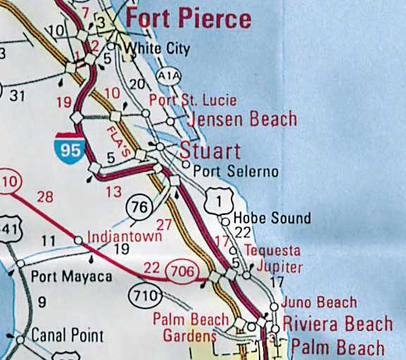
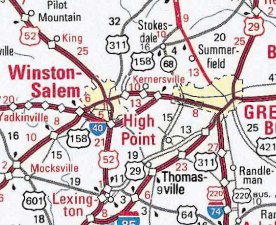
 |
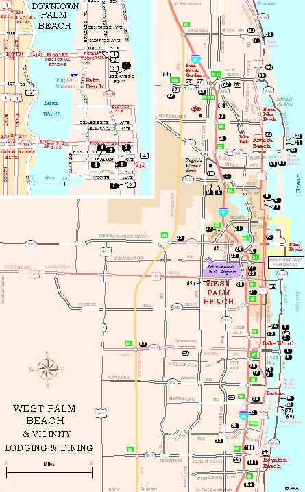 |
| Figure 4. Results of Automated
Extraction for Tourbook Spotting map for West Palm Beach. The default extraction
is then manipulated by the cartographer as needed to produce the final
map. Some features need to be added from master, others removed from the
product. |
Figure 5. Finished Tourbook Spotting
map for West Palm Beach. The default extraction has been modified as needed,
the map was finished with ArcMap. |
Generalization requirements for different map types
This section outlines some of the different generalization
needs for our products, specifically Sheet Maps, Tourbook Maps, Internet
Triptik.
As mentioned earlier, the greater the difference between
the source scale and the product scale, the more generalization work there
is to be done. Our experience with generalization is a direct result of
the types of maps we have developed, and the chronological order in which
we have produced them. If we started our GIS map production system with
smaller scale maps like the Regional maps rather than the large scale maps
like the city maps, we might be saying different things today about generalization.
Sheet Map production
Sheet maps are large maps, typically with multiple views
and indexes, that are folded to fit in a car's glove compartment. They
include the CitiMap, Vicinity, State, and Regional Planning map series.
AAA's sheet map production system runs on UNIX Arcinfo 7.2.1 and is based
on ArcTools, with custom functionality added by AAA to create the custom
look of our products.
We have recently started producing smaller scale Vicinity,
State, and Regional maps, and are now encountering many more "opportunities"
for generalization. Currently some generalization is being done manually,
but we intend to automate as much as we can once we have identified the
operations needed. We are still compiling information on the generalization
requirements for these map products.
As the scale of the product becomes smaller, it is much
more likely that multiple features will occupy the same space, and will
need to be reconciled to be clearly visible. Some features would be lost
completely without generalization. The only way to convey all the information
is to abstract and generalize features, compromising real world locations
for legibility.
Our Regional maps present new generalization challenges.
The Southeastern States map is easily one third of the country. Most of
the visitors to the southeast, particularly those who drive there, are
from the northeast, and some from places as far away as Chicago and Canada.
In order to accommodate these travelers, the back panel of our Southeastern
States Regional Planning map extends as far north as Chicago, Detroit,
Windsor in Ontario, and New York.
We are still investigating the generalization issues for
producing Regional maps of this scale from a detailed, street-level database.
The main challenge will be the enormous volume of data to filter.
Tourbook Map production with ArcMap
The Tourbook map production system is currently being developed
with ArcGIS 8.1 on the NT desktop.
We needed a system that could make a large number of small
maps easily and quickly. Rather than add more custom functionality to the
UNIX Arcinfo system, which is no longer evolving as a product, we decided
to see if the new ArcGIS 8.1 desktop tools could be used to create Tourbook
maps. The desktop tools have a lot of built-in functionality that appear
to surpass the custom tools we developed for UNIX.
Because the Tourbook maps cover a very wide range of scales,
this presents an opportunity for us to make a lot of progress on our automated
generalization procedures. The Tourbook map production system is in its
early stages of development, so many issues related to generalization on
the desktop are still being explored.
We are going ahead with cartographic production using
ArcMap, but we are going continue to run Automated Extraction for Tourbook
maps on UNIX because we believe the processing speed for the extraction
is better on UNIX than with ArcMap. At least this was our conclusion during
the ArcGIS 8.1 Beta period. Now that Arcinfo 8.1 is final, we will have
to reassess, and see if our Automated Extraction can be done efficiently
on the desktop.
We are also Beta testing the Adobe Illustrator Export
from ArcMap, and the possibility of using Adobe Illustrator for finishing
the Tourbook maps. Under this scenario, we would get the map as far as
possible with ArcMap, and just use Adobe Illustrator to add graphic effects
to the map.
Internet Triptik
The Internet Triptik (ITT) is primarily an Internet routing
service rather than a map production system. ITT's needs and approach to
map generalization is different than for AAA's paper map products. The
primary purpose of the Internet Triptik is to route someone from an origin
to a destination. In addition to showing the route itself, the Triptik
maps show major roads in the vicinity of the route in order to properly
orient the driver, and to allow some flexibility should the driver need
to stray from the route.
The Internet Triptik relies on pre-generalized datasets
for specific scale ranges. Depending on your scale, you will draw from
one of a number of predefined datasets for specific scale ranges. This
approach is quite different from our paper map products, and is driven
by the need for fast performance over the Internet.
Generalization Issues for Various Paper Map Types
Some of the generalization issues we have identified for
various map types include:
-
Line simplification. We do simplify lines for the Internet
Triptik layers, but we don't always simplify lines for paper products.
In general, we simplify only where necessary to improve performance of
displays, not necessarily for smoother appearance.
 |
|
Figure 6. Line detail of Chesapeake Bay at vicinity
scale, from the Washington DC Beltway and Vicinity map.
|
-
Road Convergence. As they converge on urban areas, major
roads tend to occlude each other. Due to the scale of the map and the thickness
of the road line symbol at that scale, a single line could obscure a number
of nearby roadways that run parallel or tangent. For example, Interstate
95 and the Florida Turnpike converge and run within a few hundred feet
of each other for several miles (see Figure 7). At
the state and regional scales, these roads would blend together. Until
we find an automated way to do it, we will manually displace one or all
roads affected on each map product.
 |
 |
 |
|
Figure 7. Convergence of Interstate 95 and Florida Turnpike.
This shows actual positions of roads without generalization.
|
Figure 8. Convergence - generalized on State map product.
|
Figure 9. Convergence - generalized on Regional map
product.
|
-
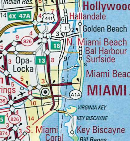
Barrier Islands. Some coastal areas of the United States
have barrier islands located just offshore. Examples of these include the
Florida Keys, the Outer Banks, the Jersey shore, etc. These islands are
connected to each other and to the mainland by bridges and causeways. At
a state or regional scale, some of the islands are so narrow that they
disappear under the thickness of the highway symbol. The smaller islands
have to be enlarged and displaced along with the roads that traverse them,
so that they can remain visible. The examples below are from the Miami
area.
 |
 |
 |
|
Figure 10. Offshore islands in Miami area without generalization.
At this scale, roads cover up the smaller islands.
|
Figure 11. Generalized roads and islands on the State
map product.
|
Figure 12. Generalized roads and islands on the Regional
map product. At this scale islands are very abstract.
|
-
City Tints. Our state and regional map products show major
city boundaries in yellow tint. The city boundaries sometimes need to be
enlarged for the yellow tint to be visible at smaller scales. See Figure
13.
-
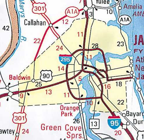
City Line weights. Since major roads converge on cities,
AAA has historically "knocked down" the symbology of roads to a thinner
line weight within the city tint boundaries. This reduces clutter, and
allows the roads to be displayed more clearly. See Figure 14.
 |
 |
|
Figure 13. City Tints enlarged for visibility on regional
map product.
|
Figure 14. City line weights knocked down in urban areas.
This example is for the Jacksonville area.
|
Updating the Database and Map Products
At AAA, our products are on regular update cycles. This means
that all the work that we do for a map this year, will have to be revisited
when the map comes up for update next year. In the meantime, our master
database has been changing; underlying vendor data has been swapped out,
and AAA proprietary information added. When the time comes to update the
map, we would like to preserve all the effort that went into making the
map the first time around, while also taking advantage of all the changes
that have occurred in the database since the map was first created.
One approach would be to simply generate the map again.
Perform all the generalization steps again on the new database to derive
a new map. Who cares what the old map looked like - just create it again
with current data. If map production were fully automated, this would be
an acceptable course of action. However, the map production system is not
fully automated. There are a number of manual, interactive steps involved
in producing a map. The output of our Automated Extraction needs to be
reviewed and adjusted by the cartographer. A considerable amount of research
in invested in making sure that the map includes the appropriate features,
that they are properly located and labeled. The index needs to be checked
and verified. Since a lot of manual effort is put into map production,
we would like to preserve this effort if possible, and not have to recreate
it year after year.
The other approach would be to have a system of notifying
the cartographer of any information which could influence the next revision
of a map. The cartographer could then retrieve the previous version of
the map, examine the changes recommended by the system, make any adjustments
necessary, and be done with the map. The advantage of this approach is
that all generalization work is preserved and does not need to be done
again.
Update is an issue at the fringe of the generalization
puzzle. If I had a system that could generalize a map perfectly every time,
I would probably not care so much about map update - I would simply re-generate
the map with new data. But since we don't currently have a fully automated
map generalization system, I do want to preserve the manual, interactive
effort that went into making the map in the first place, so I don't have
to re-do that effort every time the map is updated. We don't want to have
to treat each revision as a brand new map.
Updating the Master Database
AAA updates the master database throughout the year as new
information becomes available. In addition, we refresh the master database
with new vendor releases. We have the challenge of loading new vendor data
while at the same time preserving AAA modifications to the database. From
one vendor release to another, features may be deleted from the database,
added to it, or (as in the case of realignments) removed and re-added to
the database.
The fact that our database is so dynamic does have an
impact on how we update our map products. For example, the map I create
this year will have to be updated next year. Over the course of a year,
the underlying database will have changed. The problem is then, how to
bring the appropriate changes that have occurred to the master database
down to the product layers, bringing in the new information while at the
same time preserving product-specific changes and generalization.
We are trying to deal with database update and map update
as separate issues. In other words, the problem of how to preserve master
level changes from one vendor release to another is different than the
challenge of how to apply changes in the master database to particular
map products. In this view, database update has nothing to do with the
maps that were derived from the data. From this perspective, it is easy
to see map update as a separate issue. We have a good workflow in place
to update the database with new vendor data, while at the same time preserving
AAA value-added information. We feel we have the database update problem
resolved, and are now ready to focus more attention on the map update process.
Updating Map Products - preserve previous version's work while accessing
latest information
Map update is not a problem on the top of everyone's mind
when it comes to generalization, but it is a real need for a publisher
like AAA who must update map titles every year. We find that a lot of organizations
typically make one-time maps, rather than maps to be maintained year after
year. Organizations that do maintain maps generally do so at the individual
map level, not at the master database level like we are attempting to do.
The relationship between generalization and map update
may seem like a bit of a stretch, but it is a very real need for us. It
could be argued that it is not a generalization problem at all, but we
would like to see continued research in the GIS community regarding how
generalization and map update should work together.
Ideally, when it came time to update a map, the system
would make any necessary additions and deletions for us. Under our current
model of creating product coverages or layers, it would be useful if an
automated generalization process could look for new features and remove
or replace old features automatically based on Permanent ID, or by comparing
last year's generalization to this year's.
Until then, we have to handle the Map Update process manually.
Our current approach to map update is described below, in the hopes that
future breakthroughs in the automation of generalization will make this
kind of interactive work unnecessary.
Re-extract features
Features in the master database may have changed since the
map was last produced. In order to get the latest map information, all
features for the map are extracted again to local coverages. Automated
Extraction is run again to get a new default set of layers for this map
type and scale.
-
Find new features in the database that should go on the map.
-
Find features on the map that have been deleted from the
database, determine if they should be removed from map.
Change Detection - Compare old product layers with new extracts
Once the layers are re-extracted, the cartographer can compare
the new extracts with the old map. We can provide some automated assistance,
such as identifying all Permanent Ids that are new, or all PIDs that appear
in the new map but no longer appear in the new data (deleted or realigned).
These reports can give the cartographer a set of old and new (or changed)
features to examine, but it is still up to the individual cartographer
to determine if a feature should indeed be removed from or added to the
map.
-
Identify changed features, such as a realigned highways.
In this case, the old features need to be dropped from the map and the
new features added from the master database.
-
Preserve cartographic displacements. If a feature is displaced
for cartographic reasons, preserve that displacement, even for features
that are replaced or realigned.
-
Preserve other forms of generalization. If features are simplified,
or typified, and they need to be replaced, the same generalization operations
will have to be performed again on the replacement features.
Performance of UNIX Workstation Arcinfo and NT Desktop Arcinfo
A lot of our ideas and plans for generalization are based
on our experience with UNIX Arcinfo. With the Tourbook Map project, we
have now split our development and research efforts between two platforms
(UNIX and NT). We continue to use UNIX for sheet maps and heavy duty data
crunching, but have made a philosophical decision to limit our enhancement
of the UNIX map production system while we learn what ArcMap can do. We
are waiting to make the switch to the desktop. Performance is the factor
that will cause us to switch to the desktop, or stay with UNIX.
We are just starting to work with the desktop. We know
we can make maps with ArcMap once the data layers are prepared through
the UNIX Automated Extraction. We have yet to get into geodatabases and
modeling generalization behavior into our objects. It is also unclear to
us how much generalization technology is currently available through ArcGIS,
or how advances will be phased into future product releases.
As we become more comfortable with Arcinfo 8.1 desktop,
and as the performance of this product improves, we may be able to do Automated
Extraction, and all generalization, on the desktop.
We look forward to working with the object-oriented technology
of the ArcGIS desktop. This is new technology for us, and we are particularly
interested in the following capabilities:
-
Building behavior into an object so that it would know how
to represent itself in different products and at different scales
-
Building sophisticated behavior that would consider the relationships
between different objects in selecting which objects should appear on a
map.
-
Performance of these operations in a real-time production
environment
-
Can the object-oriented approach facilitate the map update
process ? Smart objects that automatically update themselves in map products.
-
Is ArcMap capable of producing one of our very large sheet
maps ? Is there a size limitation for acceptable performance ?
Will processing speed and software ever get to the point
where maps can be generalized and customized in real time, or will GIS
software developers write tools to automatically propagate master level
changes to affected map products ? Or will we have smart maps that update
themselves ? This conference is an excellent opportunity for the users
and vendors in GIS to compare notes on what is important to them. The user
community needs to let GIS developers know how they are using their software,
what we would like for them to improve, as well as what features are not
as important to us.
Miguel Garriga
Project Manager
GIS Development & Support
1000 AAA Drive, mailstop 56
Heathrow, FL 32746
mgarriga@national.aaa.com
Geoff Baldwin
Senior Cartographer
GIS Cartography
1000 AAA Drive, mailstop 56
Heathrow, FL 32746
gbaldwin@national.aaa.com