Bringing GIS to Rural Landowners: Experiences in Technology Adoption and ArcIMS
Amy Hays, Neal Wilkins
ABSTRACT
This paper discusses the development of the County Level Easily Accessible Resource (CLEAR) program, an outreach and education effort directed by Land Information Systems, part of the Texas A&M University System. This project is designed to help support private landowners, communities, and local decision makers involved in natural resource management. One of the limiting factors for these decision makers is access to both tools and information regarding the natural resources. The CLEAR project is a public access program involving the implementation of ArcIMS and the adoption of this type of technology at a county and community level.
http://clear.tamu.edu
Introduction
Rural land is the largest storehouse of economic and ecological wealth in the United States. While every state can claim one or more large metropolitan hubs, usually containing their largest populations, there are vast acres of rural lands still left in the United States. These lands provide most of the food resources, natural resources, water, and other consumptive uses that citizens and visitors enjoy. Managing those resources in Texas, as with most states, are private landowners. In Texas, 97 percent of the land is privately owned with 144 million acres in private land ownership. However, the management of those lands, as well as the rest of the private lands across the United States have not enjoyed the same benefits as public and metropolitan lands when it comes to the application of Geographic Information Systems (GIS) technologies and land management. If that same amount of land were held as public lands, it would be a large and time consuming land management task for any agency to oversee; and undoubtedly would be done using GIS technologies. Private landowners and communities need access to both data and GIS technologies through a server-side portal in order to support critical land management decisions.
The Internet has increased our abilities to bring technologies and applications to rural areas. Yet, the adoption of technology for rural areas, particularly for private landowners, is not the same as deploying these technologies in urban communities where there may be an abundance of external resources and technology services (for example, faster connections, larger bandwidth line carriers) to assist with distributing data and applications to the public. In addition, unlike urban areas, rural communities do not have as much data resources to provide for baseline data. Yet, in terms of natural resource management, there is a great need for timely and accurate information about what is on the ground.
The Land Information Systems laboratory, at Texas A&M, recently developed a prototype of a system to test both the integration of new spatial technologies for land management, and the practical side of implementing those technologies to private citizens and rural communities. The goal of the project was to design a system that would meet the needs of rural landowners for natural resource decision support, and to document the adoption of spatial technologies for rural application.
Background
The County Level Easily Accessible Resource (CLEAR) project got its beginnings from the realization that there was an unmet need for natural resource information for private landowners. Most rural landowners only have access to data that is out-of-date, hard to collect, and very difficult to understand. They are forced to make decisions in a tactical manner based on their knowledge of their properties with the resources in hand, rather then employing more strategic planning.
In 1995, the Texas Natural Resource Information System (TNRIS) mapped the state in 1 meter CIR Digital Ortho Quarter Quads (DOQQ). This data set entered into the public record and was available at low cost to all parties. In addition, because of the NSDI (National Spatial Data Infrastructure) and FGDC (Federal Geographic Data Committee) efforts, vector data was becoming more and more available for use. However, private landowners and rural communities were, for the most part, unable to take advantage of this data because they lacked both tools and expertise in using, manipulating, analyzing, and organizing the data. So, while good data existed, it was unused by most private landowners.
CLEAR was conceived on the idea that tools that were beneficial for state and federal land managers could be developed for deployed on rural lands. In addition, those important data that reside at the local level could only be obtained through partnerships within communities. The effort was to develop the technology to deploy a spatial mapping system over a network environment, and to promote adoption of these spatial technologies as part of natural resource decision-making and long-term land management strategy.
CLEAR was planned for a three-phase approach:
- Data acquisition for two prototype counties
- Local involvement from both landowners and local data providers, and
- Development of an Internet-based GIS
CLEAR Prototype
Two counties were chosen for the CLEAR prototype. Washington and Gillespie counties are situated in rural communities that were experiencing land ownership changes and land fragmentation due to the changing demands for rural lands. Both of these communities are within 100 miles of a major urban center. These counties are representative of many parts of Texas where shifting land uses, changing landownership objectives, and an increase in absentee ownership has created a new, and largely unmet, demand for spatially-explicit natural resources information.
Both of our prototype counties had county appraisal districts (local public entities that manage land transfer and evaluate land use for taxation) that kept land records in a GIS format. This was a critical local information source. We formed local steering committees in each county - these provided critical information about how landowners might use spatial data and the variability of land management challenges. We used the steering committees involvement through meetings and work groups to gather critical data and to design the Graphical User Interface (GUI) for the system. Landowners and community leaders were represented on the local steering committees; many of which represented the intended end-user. As a general rule, those committee members were unfamiliar with GIS technologies and many were unfamiliar with basic computers technology.
Over the course of one year, the groups met with developers from the Land Information Systems laboratory. We were able to document the views on land management and the types of information that would be useful for land management and decision support. As one of the most important and useful outcomes of the local steering committees, we gained local support from opinion leaders.
CLEAR System Development and Deployment
From the work groups and local partnerships, we developed a data library containing vector layers from state and local resources, as well as 1-m CIR DOQQ's. Our development task was to design and deploy a system that could provide GIS tools and up-to-date data over a public network. The obvious distribution platform was the Internet, even with rural bandwidth and speed issues. The large file sizes of the data sets (in particular the DOQQ's which in native format were over 10 GB alone per county), and the need to provide the most current data sets precluded the use of CD's and customized software.
The CLEAR development team decided to use Esri's ArcViewIMS as to deliver the internet-based GIS. Early on, we considered customized programming and software. But we finally settled on commercial software. Our major considerations were ease of design, long-term stability, and maintenance.
ArcView IMS offered the basic tools landowners suggested would be most useful (zoom, pan, measure, and find), as well as supported both vector and raster files. We found that landowners favored DOQQ's as the basic underlying data set because it gave them a realistic visual representation of land resources. We found that landowners were more apt to understand and use other datasets (e.g., soils, roads, hydrology, elevation models) when actual aerial image was associated with the information. Serving these additional data sets did not require any additional database software outside ArcViewIMS. Shortly after choosing ArcViewIMS as a platform, Esri launched the beta program for ArcIMS and the development group switched to this platform.
Overall, our single largest data problem was the file size and transfer rates for the raster data. The DOQQ's in their native georeferenced .tif files were time consuming to load and too large to reasonably transfer over modem connections (which were prevalent in the prototype counties). To compress the images, we used LizardTech's MrSidTM software. With images compressed at a 1:18 rate, the load time was reduced by approximately 80% with minimal compromise of quality.
An additional problem was encountered with the Java version of ArcIMS for deployment of CLEAR. The download time for the java components for the ArcIMS Java version were unreasonable for rural modem users. While the java version added functionality, the download time was not acceptable to users. Therefore, only an HTML ArcIMS version of CLEAR was made available.
CLEAR GUI
The original GUI for the CLEAR system was developed using the default templates with ArcIMS. After testing this interface, we made several changes to make the interface easier to use for general users. One of the main changes we made was the replacement of all symbolized tools with text buttons. General users were not familiar with, with using icons to activate tools. Another change we made was dividing tools into 2 categories: those that were general map functions and those that we considered advanced. We then customized the menu into tabbed regions. We simplified the legend and placed the scale dependencies on layers to decrease load time. We found that some users wanted to use DOQQ data immediately upon entering the system, but were frustrated at the load time it would take for 80 images to load into the IMS. Therefore, we set the DOQQ's in MrSid format at a scale dependency for use only at close resolutions. This saved substantial download time. Even if some users were familiar with the data (they knew what to expect the data to look like) we found that they did not always have the knowledge of system operations. One of our tasks was to streamline the system so that these users did not have to seek data knowledge that was unnecessary. Data layers and scale dependencies were set by natural resource biologists who directed the data sets to be scaled most beneficially.
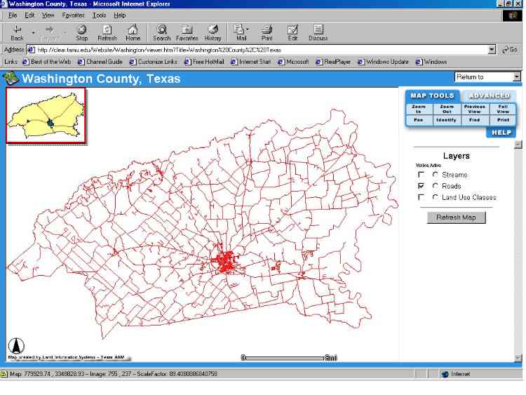
Figure 1: Screenshot of the CLEAR GUI. View from initial load.
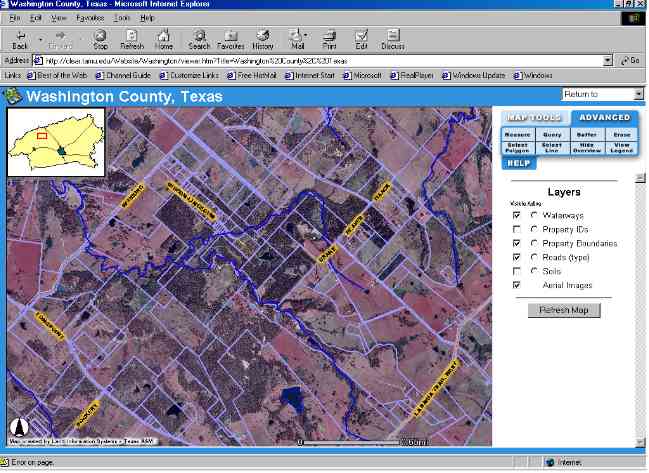
Figure 2: Screenshot of CLEAR GUI. Demonstrates scale dependencies and toolbar.
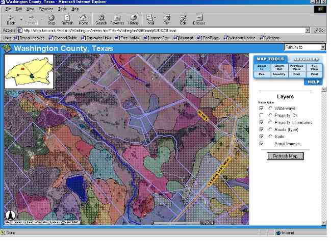
Figure 3: CLEAR GUI. Layering of soils layer over the DOQQ base layer.
Current Status
The CLEAR system (http://clear.tamu.edu) has been active since January 2000. Since that time it has gone through three major revisions. The site operates on a single dedicated web server (Dell PowerEdge 4300, 512 Mb RAM, 60 Gb hard drive). IIS 4.0 drives the CLEAR site on NT 4.0 platform. Plans are to expand the system in 50 more counties over a three-year period.
Outcomes
This project focused on both the technological and social aspects of developing a public Internet mapping system for natural resource management. There was adequate literature to support the use of GIS for natural resource management, and the potential benefits GIS systems could add to the ability to enhance the decision-making process for landowners. The unknowns for this project revolved around the design of a networked and public GIS system that was appropriate for non-GIS users.
Adoption of Internet Mapping Systems for Rural Landowners
While working with the local landowner focus groups, it became apparent that there were many ways in which landowners would like to use data and information that differed from the way the development team envisioned the data and information being used. This reinforced the reason for the development team to delay the deployment of the actual IMS until the work groups had been collaborated with. Critical insight was given by the work groups on the most common needs and uses for the proposed data sets. This later assisted the development team in designing the GUI and data layer presentation.
Landowners were both excited by the prospect of using high-quality and relevant data sets, and apprehensive about the increased availability of data for the public as a whole. They were hesitant to have so much open access to data that related to their lands. As the system evolved and the working groups were able to explore the capabilities of the system, the apprehension about the data availability significantly decreased. In many cases, members of the working group assisted others in the county with access and use of the CLEAR system.
One important factor in the deployment of the system in the counties was the partnerships with local data providers (city, county, and utilities). In each of the counties, these entities wanted better and more widespread access to their data for their use, and as a public outreach mechanism. However, very few local entities have the money or employee base to be able to implement IMS systems themselves. The partners in the local communities provided data for the CLEAR system and in some cases were able to provide a local computing resource for the public to use.
The overall goal of the CLEAR system was to improve access to data for natural resource management and to foster a better understanding of the local natural resource base in each of the prototype counties. The system design and development was tailored so that no matter what the intended use of the system was, natural resources acted as the basis for all use. In many instances, the system was used for purposes other then land management decisions (for instance, it was used by real estate agents to show potential buyers property before a site visit). Yet, by design, natural resource inventory was inherent part of the system.
Adoption of the system for non-GIS users, particularly rural landowners, was greatly increased by working with local workgroups and seeking data partnerships within counties. Preparing a county for IMS deployment prior to the system launch proved to be favorable in avoiding multiple re-designs of the system. Many of the local landowners were able to assist in both giving insight for development and in forming new data partnerships with local entities they were familiar with.
Development of an Internet Mapping System for Natural Resource Decision Support
The development of the IMS part of the CLEAR system happened in two phases. The initial phase involved the collection, organization and management of the relevant data layers to be used for each of the prototype counties. The second phase dealt with the programming and deployment of the IMS over a publicly accessible website.
Phase one was carried out over a three-month time period. A large amount of the statewide data is cataloged and stored on the TNRIS (Texas Natural Resource Information Service) website (http://www.tnris.state.tx.us). Digital Ortho Quarter Quads were obtained from Texas Parks and Wildlife (TPW) through an informal partnership. Other data was collected through publicly accessible websites.
The county partners contributed three important datasets. Road and parcel (property boundaries) layers were kept through the county appraisal districts and represented the best available information. County entities, unlike state agencies in Texas, do not participate in cataloging their data with TNRIS. Therefore, some of the most valuable layers can only be obtained directly from county offices and entities. These data are better represented at the county level because they are continuously maintained. A local water district in one of the counties provided a third data set, location of water wells.
The installation of the IMS was done according to software instructions. A single server was chosen to minimize maintenance and internal networking issues. Custom programming was done to the GUI to rearrange the toolbars and legend. At the prototype phase, no specialized tools were added to they system.
Overall, the speed of the CLEAR IMS over the Internet exceeded expectations. The majority of users were modem users of 28.8 baud or less. The raster portion of the IMS could take 90-120 seconds to send the requested images to the client. Vector data could take 3-12 seconds.
The majority of problems with the system came from the unusual nature of IMS. Most users were familiar with static web sites where true interaction was limited. The average end-user had trouble with understanding the GUI the first time they saw it. Most users required repeated exposure. One of the most common areas of confusion was waiting for the request to return to the client. Most users sent a repeated request or a second request while they were waiting for the first and received error messages.
Browser version was another area of trouble. Most users had not updated their browsers from the time of the initial machine purchase. There were many instances where the browsers were two or more versions behind the minimum needed for ArcIMS. This added time to the user session because they had to retrieve an acceptable version of the browser over already slow modem lines.
Overall, the design and deployment of the CLEAR IMS was a relatively easy task. The long-term strategy of the site is to enhance it will new tools and capabilities that will require further customized programming.
Conclusions
Practical development, deployment, and adoption of Internet Mapping Systems for non-GIS users requires a more planned approach then deploying a system to typical GIS users. The tendency of developers of new technologies is to deploy among all users in the same manner. However, when considering deployment outside a user group familiar with the technology, more groundwork and effort should be put into understanding how that group perceives the data and how they seek to use the information.
One of the most beneficial, albeit time consuming, aspects of deploying the CLEAR system was to work with end-uses before beginning the design and development of the system. It not only gave valuable insight to the development team, but fostered new partnerships and support among end-user groups.
CLEAR was developed to meet the needs of private landowners for natural resource decision-support. Natural resource management, outreach, and education efforts are important to the long-term sustainability of the nations resource base. Natural resources tend to take a back seat compared to the general needs of the population (needs such as crime, health, and housing). Very few counties, especially rural counties have the resources to organize tools to assist in supporting their natural resource base. In the case of CLEAR, Land Information Systems - as part of the Texas Agricultural Extension Service - was able to fill a role for coordination, cooperation, and development of a public system to support natural resources.
The future of the CLEAR system is currently being planned. The lessons learned about the process of technology adoption and the value of IMS for natural resource management will be used to develop new research and outreach efforts through Land Information Systems.
Acknowledgements
The prototype of CLEAR was funded through Renewable Resource Extension Act (RREA) and the Texas Agricultural Extension Service Risk Management Initiative.
Landowners and partners in Washington and Gillespie counties were instrumental in developing and deploying the CLEAR prototype.
Texas Natural Resource Information System (TNRIS) (http://www.tnris.state.tx.us) and Texas Parks and Wildlife (TPW) (http://www.tpwd.state.tx.us) willingly shared their data, resources, and experiences.
Amy E. Hays
Information Systems Coordinator
Land Information System
Texas Agricultural Extension Service
111 Nagle Hall
TAMUS 2258
College Station,Texas 77843-2258
979-845-7471
979-845-7103
ahays@tamu.edu
R. Neal Wilkins
Associate Department Head and Extension Program Leader ,
Department of Wildlife and Fisheries Sciences
Texas A&M University System
111 Nagle Hall
TAMUS 2258
College Station,Texas 77843-2258
979-845-7471
979-845-7103
nwilkins@tamu.edu