 |
Gary L. Christopherson, Tisha K. Entz
Given the ever-present temporal and financial constraints facing them, archaeologists are always looking for ways to improve the efficiency of their fieldwork. Projects are generally charged with finding a large number of sites while expending a minimum of time and money. In this study, the charge was as follows: over the course of 35 days, find as many sites with Iron Age I pottery as possible in an area of 19,308 acres (7814 hectares) on the Jordanian plateau. Given the size of the region, the limited number of days, and the fact that the funding for the project provided only a single vehicle, efficiency was essential to the success of the study. This need for efficiency led to the use of ARC/INFO to develop a probability model for Iron Age I sites in the region. It was hoped that the model would significantly decrease the area to be surveyed, and significantly increase the number of Iron Age I sites in the survey database. This paper discusses the archaeological data, the reason Iron Age I sites were sought, the construction of the model, the use of the model in the field, and the results of the fieldwork.
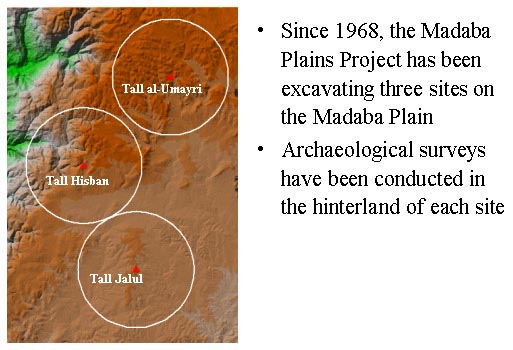
The Madaba Plains Project (MPP) has been involved in the archaeology of Jordan since 1968. It is a large, multidisciplinary project that has concentrated its efforts on the excavation and hinterland surveys of three regionally important sites: Tall Hisban, Tall Jalul, and Tall al-Umayri (Figure 1). One of the important discoveries of these excavations and surveys was a cyclic pattern of settlement intensification and abatement. With few exceptions, settlement data from excavation and survey move in lock-step through these cycles. That is, when the survey indicates an increase in hinterland settlement, excavation data shows a corresponding increase in the size and importance of the major sites in the region. One exception is the Iron Age I period at Tall al-Umayri. This portion of the paper will present a summary of the archaeological data from the Umayri excavation and survey, and begin a discussion of the questions raised by these data.
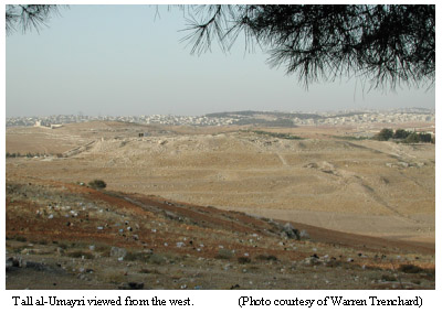
Tall al-Umayri is located just a few kilometers south and west of Amman, Jordan (lat/lon coordinates 31 52 07N, 35 53 14E - Palestine Grid coordinates 234200E, 142000N). The site covers approximately 16 acres (6.5 hectares) (Ibach 1987) and has been extensively excavated over the course of eight field seasons (1984, 1987, 1989, 1992, 1994, 1996, 1998, 2000). Habitation at the site stretches from the Early Bronze Age through the Hellenistic period. To date, these excavations have revealed substantial occupation during the Early Bronze Age, Iron Age I, and Iron Age II. Additionally, while exposure of Middle Bronze Age loci has been limited, the presence of massive MB IIC defensive structures may indicate a significant presence during this period. (Herr et al. 1994, Herr et al. 1991b, Younker et al. 1996).
Although not used in the construction of the probability model, the excavation of Iron Age I Umayri provided an important context for this study. Following an earthquake that can be dated to circa 1200 BC, Tall al-Umayri experienced a building boom, becoming one of the largest hill-country sites in the Levant (Younker et al. 1996: 75). The excavation in Field B has revealed an extensive fortification system comprised of a reuse of the MB IIC moat, a large retaining wall that supported a thick rampart leading to one of the earliest and best preserved Iron Age I casemate walls (Clark 1991: 57-58, Geraty, Herr, and LaBianca 1987: 192, Geraty et al. 1986: 130-131, Herr et al. 1991a: 159, Herr et al. 1994: 151-154, Younker et al. 1996: 75). Inside the city a number of domestic buildings have been excavated, including a well preserved four-room house that used the casemate as a broad room across the back of three long rooms. In this casemate room, approximately 40 collared rim pithoi, compelte with carbonized barley, were found broken on the floor, along with six bronze weapons, several stone "ballista," and the burnt remains of two humans (Younker et al. 1996: 74-75)). Destruction of the Iron Age I city, given the quantities of uneaten food and the 1.5 - 2.5 meters of burnt debris, was both sudden and violent, leaving Umayri uninhabited for centuries (Herr et al. 1994: 154, Younker et al. 1996: 75).
The context provided by these data is that of a period of settlement intensification. The size of the site, the mass of the defenses, the scale of the storage facilities, and the impressive domestic architecture, all indicate that Tall al-Umayri would have needed extensive support from beyond its walls. Support to build and maintain its fortifications, to work the fields, to process and store the harvest. Typically, this level of support would be evidenced by intensive settlement in the region surrounding Tall al-Umayri. The natural conclusion to be drawn from these data is that during the Iron Age I, the Umayri region should have been experiencing a period of intensive hinterland settlement.
The Umayri regional survey began in 1984 as a component of the Madaba Plains Project's excavation at Tall al-Umayri. Operating within a five-kilometer radius around the Tall, its stated objective was "to gather data pertinent to reconstructing changes over time in patterns of food production in the hinterlands" (LaBianca 1989: 23-24). In order to achieve this goal, the survey was divided into four main emphases: a random sample survey, a judgment sample survey, an environmental survey, and an ethnographic survey (LaBianca 1989: 24).
Of these four surveys, the random survey and judgment survey are most important to this discussion. The random sample survey was carried out during the first three field seasons and has provided a baseline, against which many of the results from the other surveys can be measured. This survey visited 100 randomly selected survey parcels, 200 x 200 meters in size, collected pottery and recorded various environmental data in an effort to collect a representative sample of the survey region's environment, ceramics, and antiquity sites (Figure 2). The random nature of the survey was designed to accomplish two main goals: first, to force investigators into areas that might otherwise be overlooked because of access difficulties, and second, to increase the validity of various statistical analyses concerning the environmental and archaeological characteristics of the region (Christopherson 1997a, Cole 1989). In retrospect, each of these goals was met.
The judgment survey was intended to provide the primary archaeological component to the survey database. Employing traditional methodology, the judgment survey followed roads and wadis to examine areas thought likely to produce antiquity sites. In addition, this survey team was responsible for recording archaeological sites discovered by the other components of the hinterland survey, principally the random and environmental surveys. Finally, it should be noted that although discussed separately here, all four components of the survey were highly integrated, often traveling and recording together. In fact, most of the sites recorded by the judgment survey were actually discovered by the random sample and environmental surveys.
Through the efforts of these survey components, the Umayri regional survey recorded 133 sites over four field seasons (Figure 2). These sites ranged from small single feature sites to mid-sized urban centers, and from the Lower Palaeolithic to the Late Islamic periods. The final publication of these sites is in its early stages but brief descriptions can be found in several preliminary reports (Boling 1989, Christopherson 1991, Christopherson 1997b, Christopherson et al. 1998, Geraty et al. 1986, Geraty et al. 1990, Geraty et al. 1991, Krug 1991, Younker 1989, Younker 1991a, Younker 1991b).
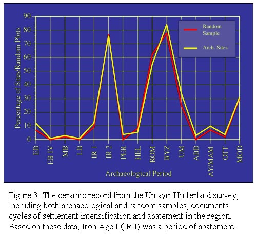
In both the random and judgment surveys, Iron Age I was poorly represented. Of the 100 random sample plots, only nine had Iron Age I pottery. Of the 133 archaeological sites recorded by the judgment survey, only 16 had Iron Age I pottery. Figure 3 shows the relationship of these numbers, compared to other periods in the Umayri hinterland. Clearly Iron Age I was a period of low settlement activity in the region. The sixteen sites comprise just over 12% of the total number of sites in the region. This compares favorably with the 9% of Random Squares producing Iron Age I pottery. The natural conclusion to be drawn from these data is that during the Iron Age I, the Umayri region was experiencing a period of settlement abatement.
There are a number of important questions raised by these contradictory data sets. Of particular importance to this study are two questions related to the lack of Iron Age I material from the hinterland survey: 1) Would it be possible to locate additional Iron Age I sites in the Umayri hinterland? and 2) If additional Iron Age I sites were located, would this change our ideas about settlement during this period?
With these questions in mind, the authors developed a probability model for Iron Age I sites in the Umayri hinterland. This model was based on the following assumptions:
Using these assumptions, the model was designed to make connections between archaeological sites with Iron Age I pottery and their local environment. The environmental signature for these sites were then used to focus fieldwork in those areas most likely to produce additional sites with Iron Age I pottery. This section of the paper summarizes the creation of this model.
There are a number of different multivariate statistical techniques that can be employed to discern connections between the environment and ancient humans (Kohler and Parker 1986, Kvamme 1988, Warren 1990a, Warren 1990b). In this study, probability models were constructed using logistic regression. Logistic regression takes an inductive approach to the modeling process, in that it begins with what is known about individual cases and applies this knowledge to reach general conclusions. In terms of this study, a logistic regression model takes what is known about the location of archaeological sites with Iron Age I pottery, and uses this knowledge to make statements regarding Iron Age I site selection processes for the Umayri region as a whole. There are several advantages to this approach, not least of which is that by beginning from what is known there is a degree of confidence that the model will actually reflect choices made by ancient people rather than what we think they would choose (Kohler and Parker 1986). When attempting to answer questions about something as complex as the relationship between ancient humans and their environment, this is an important advantage.
Regional archaeology lends itself particularly to logistic regression techniques. All regression models seek to discern the best fit between a dependent variable and a set of independent variables. The distinction between linear and logistic regression techniques is that for logistic regression, the dependent variable must be binary. That is, either 1 or 0, which can represent yes or no, on or off, living or dead, or, in the case of ancient settlement patterns, site present or site absent. Aside from this difference, the principles for logistic regression are identical to that for linear regression (Hosmer and Lemeshow 1989: 1). In this study, the ones were supplied by archaeological sites with Iron Age I pottery, and the zeros by a random sample of non-site locations.
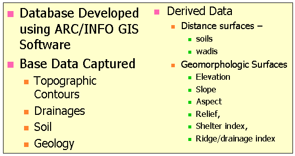
In order to discover the environmental signature for Iron Age I sites, ARC/INFO was used to construct an environmental GIS of the Umayri region. The coordinates for all environmental and archaeological data were based on the Palestine Grid and Transverse Mercator projection of the Jordan 1:25,000 series maps. The unit of measure for this coordinate system is the meter, and the point of origin is 035° 12' 43.490" E. longitude, 31° 44' 02.749" N. latitude. For these maps, there was an X-shift of 170,251.555, and a Y-shift of 126,867.909. The digitized area was contained within the following coordinates: Minimum X = 228000 meters East, Maximum X = 240000 meters East, Minimum Y = 136000 meters North, Maximum Y = 148000 meters North, representing an area of 144 square kilometers. Most of the data used in this study were in a raster format, with a cell size of 20 X 20 meters, creating a matrix of 600 rows and 600 columns, or 360,000 cells. Of the cells in the grid, 195,356 were contained within the five-kilometer radius of the Umayri survey region. Although the environmental data collected extended beyond the survey area, all analysis for this study was confined to the 5 K radius around Tall al-Umayri.
For the Umayri GIS, base data for hypsography, hydrography, physical, and cultural features were captured from the Jordan 1:25,000 series maps. Elevation, roads, and wadi channels were taken from the following sheets: Amman, Sheet 225/145 (D. Survey, 1958a), and Naur, Sheet 225/135 (D. Survey, 1958b). Additionally, geology and soil maps were created in 1992 by MPP geologist, Douglas W. Schnurrenberger. Based on 1:10,000 aerial photographs and field samples, these maps were created specifically for the Umayri GIS.
Using GRID, a variety of environmental themes were derived from these data (Figure 4). Distance grids were created using soils and drainages (distance to each of the three soil types in the region, and distance to wadi channels). A DEM was created using TOPOGRID. Derived from the DEM were eight surfaces that described various aspects of the geomorphology of the region. These included the following: slope, aspect, three measures of relief (above and below the target cell, and total relief in a neighborhood), terrain roughness (standard deviation of elevation values in a neighborhood), a ridge/drainage index (based on the view angle from each cell in the grid, low numbers equal drainages and high numbers equal ridges (Kvamme 1992b), and shelter index (created by measuring the volume of an imaginary cylinder passed at a set height above each cell in the DEM; high values equal exposed locations, and low values sheltered locations (Kvamme 1988).
|
|
To focus the model on those variables most important in the logistic regression, a stepwise procedure was used. Stepwise logistic regression differs from standard logistic regression in that it adds and removes variables based on their relative significance within the regression in order to create a maximum-likelihood model. Significance levels are based on the probability of a given variable's t-score occurring by chance. For this study, aggressive significance levels were chosen, 0.15 for adding a variable and 0.20 for removing a variable. Therefore, if the probability of a t-score for a particular variable was greater than 0.20 it was removed from the regression and if, after additional variables were removed, that probability decreased to 0.15 it would be added back into the regression. This process of adding and subtracting continues until only the strongest variables remain.
For sites with Iron Age I pottery, the stepwise process selected three variables as significant: relief above target, total relief and distance to wadi channels. Table 1 shows the results of the regression. Taken together, the model suggests that sites with Iron Age I pottery are more likely to be found in areas with significant elevation change (i.e. high total relief values), close to the top of ridges (i.e. low relief above target values), and away from wadi channels (i.e. high distance to wadi values).
|
|
|
|
|
|
| Relief Above |
|
|
|
|
| Total Relief |
|
|
|
|
| Dist. to Wadi |
|
|
|
|
| y-intercept |
|
|
|
|
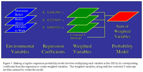
Using the coefficient values from the regression, it is possible to create a model. These numbers represent trends for Iron Age I sites in the region, with positive coefficients indicating that high values of the variable are favored and negative coefficients indicating a preference for low values. By multiplying the grids for relief above target, maximum relief, and distance to wadi by their corresponding regression coefficients, variables were created that were weighted in favor of the areas most like the local environment for Iron Age I sites. These weighted variables were then summed, along with a corrected y-intercept constant to create a model of the environmental signature for Iron Age I sites in the region, a process illustrated in Figure 5.
The y-intercept must be corrected because samples of different sizes (i.e. the site and non-site samples) can bias results of the regression. Following Warren (Warren 1990a), this bias was removed by adjusting the Y intercept constant with the equation a = a' + ln(n2 / n1 ), where a is the Y-intercept in the regression, a' the corrected intercept, ln the natural log, n1 the number of cases in the smaller sample (the site sample) and n 2 the number of cases in the larger sample (the non-site sample). Following this, the equation used to correct the Y-intercept for this model was, -2.6883 = -5.437163 + ln(250 / 16). Using this corrected intercept with the coefficients, the equation for the model was:
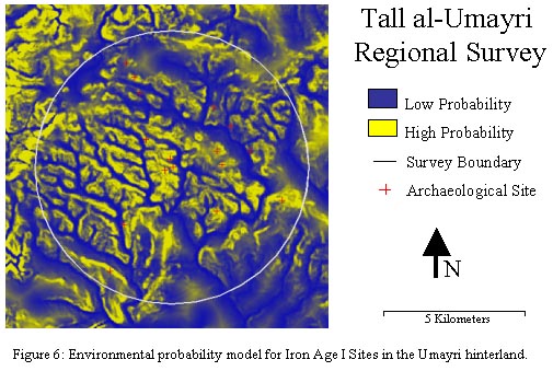
To clarify the results and facilitate comparisons, the model was logistically transformed by L = 1 / 1 + exp(-Model). The effect of this equation is to re-scale the values in the model to a probability score between zero and one for each cell in the grid (Kvamme 1992a). These scores indicate trends over the entire surface of the project area, with scores close to zero representing areas dissimilar to the environmental signature for Iron Age I sites and those close to one representing areas similar to the signature of Iron Age I sites. The resulting model can be seen in Figure 6, where yellow areas represent high probability scores and blue areas low scores. The environmental signature is clear in Figure 6, with higher probability scores concentrated along ridges, and lower scores on the plains and in the valleys.
In the context of archaeology, efficient models maximize the number of sites they correctly predict while minimizing the area needed to predict these sites. Since the probability scores in the model are scaled between 0 and 1, all values above 0.5 would be areas predicted to contain sites, and all below 0.5 would be areas predicted to have no sites. Given this, the following equation could be used to measure model efficiency:
Using this equation, values close to one would indicate strong models and values close to zero would indicate a weak model. The model created for this study encompassed just 22.5% of the project area, and contained 62.5% of the Iron Age I sites For this study, the efficiency equation was:
The fieldwork portion of this project was designed to locate and conduct a pedestrian survey of all the areas identified by the model as having a high probability for sites with Iron Age I pottery. The survey team consisted of Gary L. Christopherson, Tisha K. Entz, Rulla Qusous, Margaret Dew, and Samuel Ritter. Fieldwork was conducted during June and July of 2000. This section of the paper will discuss the different components of the fieldwork, including navigation to zones of high probability, the collection and processing of ceramics, and the identification and recording of sites with Iron Age I pottery.
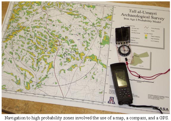
In order to use the model in the field, it was necessary to navigate to zones of high probability. The first step in this process was turning the model into a map. Areas from the model with probability scores higher than 0.5 were extracted, shaded green and yellow, and overlain with roads, drainages, villages, and topographic contours. In addition to the map, navigation tools included a compass and a Magellan ColorTRAK Global Positioning System (GPS) receiver. With these tools, navigation was a simple task. Using the map, coordinate pairs were determined for the center point of each high probability zone. These coordinates were entered into the GPS unit. Using the navigation feature of the GPS unit and a compass, the survey team drove/walked to the center point of each area to be surveyed.
Once the target area was reached, data collection began. The initial plan was to record all new sites found, but within the first days of fieldwork it was realized that the plan needed to be modified. The area surrounding Tall al-Umayri was so dense with archaeological features from multiple time periods that recording every new site would not allow time to visit all areas of high probability for Iron Age I sites. A more efficient strategy was adopted. Instead of recording every site found, the team first identified the site as Iron Age I based on the pottery collected then returned to record the site. This method eliminated the recording of sites and features with no Iron Age I material, allowing the team to focus their efforts on the discovery of new Iron Age I sites.
Data collection began with walking the target zone, collecting all ceramics from the surface and noting any archaeological features. The amount of time spent walking each designated area varied according to size and terrain, but averaged 2 man hours/5,000 square meters; therefore in an area of 10,000 square meters, it took roughly 60 minutes for four team members to collect ceramics and note any archaeological features. All sherds that were collected were placed in mesh bags and tagged with identifying information including coordinates, date, and the initials of the field supervisor. After collection, all pottery was taken to camp for processing.
Ceramic data processing involved three steps: washing, reading and replacement. Bag by bag, all sherds gathered were soaked in buckets, washed with soft bristle brushes, and dried. In preparation for reading, clean sherds were then laid out on a table with diagnostic sherds (Rims, bases, handles, and sherds with decoration or known form) placed separately from non- diagnostics (generally plain body sherds).
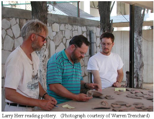
Pottery reading was the single most important aspect of finds analysis because it provided a chronological framework for everything else. Seeking consistency with earlier surveys, Larry Herr read all pottery collected for this project. As project director, and excavator of Tall al-Umayri, Herr read the pottery for earlier Umayri surveys, as well as all pottery from the excavation. His knowledge of Iron Age I ceramics on the Madaba Plain is unsurpassed.
While all diagnostic sherds were recorded, only those sherds determined to be Iron Age I were tagged and saved for further analysis and processing. All other sherds were returned to the designated Umayri pottery dump or placed in study collections. These collections will be used by educators, allowing students to handle and analyze pottery from various time periods.
When Iron Age I sherds were discovered during pottery reading, three outcomes were possible. 1) If there were no archaeological features associate with the pottery, it was ignored. 2) If the sherds came from a previously recorded site, that site was added to the Iron Age I database. 3) If there was no previously recorded site but there were archaeological features associated with the pottery, it was added to the database as a new Iron Age I site. New Iron Age I sites were revisited, and their features recorded and entered into the Umayri survey database.
By concentrating on the zones of high probability, this project was able to significantly increase the number of known Iron Age I sites in the Umayri hinterland while decreasing the area examined. The model gave 22.5% (4358 acres) of the project area probability scores above 0.5. This area was further reduced because there were large tracts of land that were inaccessible. Areas that contained previously recorded Iron Age I sites, areas that were completely urban in character, areas that contained military installations, or areas that had been fenced for agriculture or development were not surveyed. Of the total project area, 13.9% (2689 acres) fell into this category, leaving 8.6% (1669 acres) of the project area available for pedestrian survey.
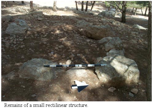
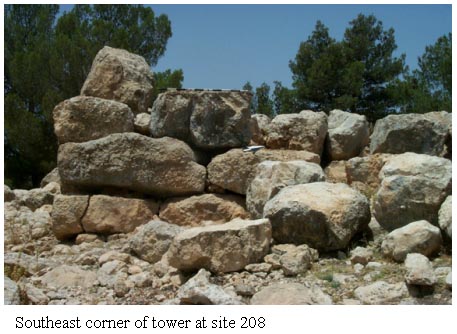
In this 8.6%, the survey identified 13 Iron Age I sites, increasing the number of sites from this period by 81%. Of these 13 sites, eight had been previously recorded, but without Iron Age I pottery, and seven were newly discovered. Most of the new Iron Age I sites are best characterized as small agricultural complexes. Typical agricultural installations, such as small rectilinear structures, terrace, walls, wine presses, cisterns, etc. were the most common features. The lone exception was site 208. This site was dominated by a 15 meter square stone defensive tower, strategically placed to provide visual control over much of the eastern portion of the survey area. Walls of large boulders were preserved as high as 3 meters, and it was still possible to enter the structure through a doorway. Inside the structure, a collapsing passage could be traversed for approximately 3 meters, to a corner, and around the corner for another 3 meters before fallen boulders blocked the way. Associated with the tower were an enclosure wall and gate, two round towers, and twin storerooms. The pottery at this site was abundant, and split evenly between Iron Age I and Iron Age II. Clearly it was an important defensive structure during both of these periods.
More problematic were the other sites, most of which were identified as Iron Age I on the basis of one or two sherds. Although this is consistent with the methodology employed by the earlier survey, making cultural affiliations based on a single sherd is not an ideal situation. In spite of the increased number of sites with Iron Age I pottery, the lack of ceramic materials from this period makes it likely that settlement in the Umayri hinterland was sparse during this period.
It is now possible to return to the two questions posed earlier in this paper. 1) Would it be possible to locate additional Iron Age I sites in the Umayri hinterland? and 2) If additional Iron Age I sites were located, would this change our ideas about settlement during this period? Clearly the answer to the first question is, yes! Pedestrian survey of just 8.6% of the project region increased the total number of sites with Iron Age I pottery from 16 to 29. If nothing else, the probability model was shown to be an effective, and efficient tool for survey archaeology.
The second question is more difficult to answer, but it is the opinion of the authors that these newly discovered sites with Iron Age I pottery are not enough by themselves to change our ideas about settlement during this period. Only two of the thirteen sites had enough ceramic evidence to convince us that they were clearly inhabited during the Iron Age I period. The remaining eleven sites had only one or two Iron Age I sherds. This indicates activity in the area, but not necessarily settlement.
The importance of this fact to our understanding of the role of Tall al-Umayri during Iron Age I should not be overlooked. Traditionally, sites with the type of infrastructure discovered at Iron Age I Umayri have been supported by a large hinterland population. This situation now seems unlikely for Tall al-Umayri, and it is necessary to consider alternative social configurations for the site. Two solutions, either alone or in combination, seem most likely. 1) The hinterland was settled differently than has been traditionally thought. It may be that the majority of sedentary people associated with Umayri lived within the walls, leaving the hinterland to pastoralists and other mobile groups. The impressive fortifications at Umayri, and the massive tower at Site 208 may be indicative of troubled times, when the security of Umayri's walls were welcomed by nearly everybody. 2) It is too late to determine the actual settlement patterns in the region. Amman continues to creep south and west, ever closer to Tall al-Umayri. As it encroaches on the region, more and more land is being gobbled up by houses and industry. More than half of the high probability zones identified by the model used in this study were already developed. It may be that the best land during Iron Age I is buried beneath modern developments built on what remains today the best land.
The authors want to acknowledge the role of individuals and groups in making this research possible. First, we offer our thanks to the Department of Antiquities of Jordan for their assistance in the project, especially in the person of Rula Qusous. Rula, along with Maggie Dew and Sam Ritter made each day enjoyable. The Madaba Plains Project has again provided us with food, shelter, and a collegial working environment. Many of our best ideas grow out of conversations over dinner. Special thanks to Larry Herr for reading all of our pottery (even the duds). Larry Herr, Doug Clark, and Warren Trenchard, Co-Directors on the Umayri project, really helped make the season a success.
Boling, R. G. 1989. "Site Survey in the el-Umeiri Region," in Madaba Plains Project 1: The 1984 Season at Tell el-Umeiri and Vicinity and Subsequent Studies. Edited by L. T. Geraty, L. G. Herr, Ø. S. LaBianca, and R. W. Younker, pp. 98-188. Berrien Springs, Michigan: Andrews University/Institute of Archaeology.
Christopherson, G. L. 1991. "Limekilns from the Regional Survey," in Madaba Plains Project 2: The 1987 Season at Tell el-Umeiri and Vicinity and Subsequent Studies. Edited by L. T. Geraty, L. G. Herr, Ø. S. LaBianca, and R. W. Younker, pp. 343-352. Berrien Springs, Michigan: Andrews University/Institute of Archaeology.
Christopherson, G. L. 1997a. "The 1989 Random Square Survey in the Tall al-Umayri Region," in Madaba Plains Project 3: The 1989 Season at Tell el-Umeiri and Vicinity and Subsequent Studies. Edited by L. T. Geraty, L. G. Herr, Ø. S. LaBianca, R. W. Younker, and D. R. Clark, pp. 250-290. Berrien Springs, Michigan: Andrews University/Institute of Archaeology.
Christopherson, G. L. 1997b. "Madaba Plains Project: Regional Survey Sites, 1989," in Madaba Plains Project 3: The 1989 Season at Tell el-Umeiri and Vicinity and Subsequent Studies. Edited by L. T. Geraty, L. G. Herr, Ø. S. LaBianca, R. W. Younker, and D. R. Clark, pp. 291-302. Berrien Springs, Michigan: Andrews University/Institute of Archaeology.
Christopherson, G. L., R. G. Boling, J. A. Cole, D. C. Hopkins, G. L. Mattingly, D. W. Schnurrenberger, and R. W. Younker. 1998. Summary Descriptions of Archaeological Sites from the Survey at Tall al-Umayri, Jordan. http://www.casa.arizona.edu/MPP
Clark, D. R. 1991. "Field B: The Western Defense System," in Madaba Plains Project 2: The 1987 Season at Tell el-Umeiri and Vicinity and Subsequent Studies. Edited by L. T. Geraty, L. G. Herr, Ø. S. LaBianca, and R. W. Younker, pp. 74-86. Berrien Springs, Michigan: Andrews University/Institute of Archaeology.
Cole, J. A. 1989. "Random Square Survey in the el-Umeiri Region," in Madaba Plains Project 1: The 1984 Season at Tell el-Umeiri and Vicinity and Subsequent Studies. Edited by L. T. Geraty, L. G. Herr, Ø. S. LaBianca, and R. W. Younker, pp. 51-97. Berrien Springs, Michigan: Andrews University/Institute of Archaeology.
Geraty, L. T., L. G. Herr, and Ø. S. LaBianca. 1987. The Madaba Plains Project: A Preliminary Report on the First Season at Tell el-Umeiri and Vicinity. Annual of the Department of Antiquities of Jordan XXXI:187-199.
Geraty, L. T., L. G. Herr, Ø. S. LaBianca, J. R. Battenfield, R. G. Boling, D. R. Clark, J. I. Lawlor, L. A. Mitchel, and R. W. Younker. 1986. Madaba Plains Project: A Preliminary Report of the 1984 Season at Tell el-Umeiri and Vicinity. Bulletin of the American Schools of Oriental Research, Supplement 24:117-144.
Geraty, L. T., L. G. Herr, Ø. S. LaBianca, J. R. Battenfield, G. L. Christopherson, D. R. Clark, J. A. Cole, P. M. Daviau, L. E. Hubbard, J. I. Lawlor, R. Low, and R. W. Younker. 1990. Madaba Plains Project: A Preliminary Report of the 1987 Season at Tell El-Umeiri and Vicinity. Bulletin of the American Schools of Oriental Research, Supplement 26:59-88.
Geraty, L. T., L. G. Herr, Ø. S. LaBianca, and R. W. Younker. 1991. "An Overview of the 1987 Season of Excavation and Survey in the Madaba Plains," in Madaba Plains Project 2: The 1987 Season at Tell el-Umeiri and Vicinity and Subsequent Studies. Edited by L. T. Geraty, L. G. Herr, Ø. S. LaBianca, and R. W. Younker, pp. 3-7. Berrien Springs, Michigan: Andrews University/Institute of Archaeology.
Herr, L. G., L. T. Geraty, O. S. LaBianca, and R. W. Younker. 1991a. Madaba Plains Project: The 1989 Excavations at Tell el-Umeiri and Vicinity. Annual of the Department of Antiquity of Jordan XXXV:155-174.
Herr, L. G., L. T. Geraty, O. S. LaBianca, and R. W. Younker. 1994. Madaba Plains Project: The 1992 Excavations at Tell el-Umeiri and Vicinity. Annual of the Department of Antiquity of Jordan XXXVIII:147-172.
Herr, L. G., L. T. Geraty, Ø. S. LaBianca, and R. W. Younker. Editors. 1991b. Madaba Plains Project 2: The 1987 Season at Tell el-Umeiri and Vicinity and Subsequent Studies. Berrien Springs, Michigan: Andrews University Press.
Hosmer, D. W., and S. Lemeshow. 1989. Applied Logistic Regression. New York: John Wiley & Sons.
Ibach, R. D. 1987. Archaeological Survey of the Hesban Region: Catalogue of Sites and Characterization of Periods. Hesban. Berrien Springs, Michigan: Andrews University/Institute of Archaeology.
Kohler, T. A., and S. C. Parker. 1986. "Predictive Models for Archaeological Resource Location", in Advances in Archaeological Method and Theory, vol. 9. Edited by M. B. Schiffer, pp. 397-452. New York: Academic Press.
Krug, H. P. 1991. "The Necropolis at Tell el-Umeiri (East)," in Madaba Plains Project 2: The 1987 Season at Tell el-Umeiri and Vicinity and Subsequent Studies. Edited by L. T. Geraty, L. G. Herr, Ø. S. LaBianca, and R. W. Younker, pp. 356-369. Berrien Springs, Michigan: Andrews University/Institute of Archaeology.
Kvamme, K. L. 1988. "Development and Testing of Quantitative Models," in Quantifying the Present and Predicting the Past: Theory, Method, and Application of Archaeological Predictive Modeling. Edited by W. J. Judge and L. Sebastian, pp. 325-428. Washington, D. C.: U.S. Government Printing Office.
Kvamme, K. L. 1992a. A Predictive Site Location Model on the High Plains: An Example with an Independent Test. Plains Anthropologist 37:19-50.
Kvamme, K. L. 1992b. "Terrain Form Analysis of Archaeological Location Through Geographic Information Systems," in Computer Applications and Quantitative Methods in Archaeology 1991, BAR International Series. Edited by G. Lock and J. Moffett, pp. 127-136. Oxford: TEMPVS REPARATVM Archaeological and Historical Associates Limited.
LaBianca, Ø. S. 1989. "Introduction to the Hinterland Survey," in Madaba Plains Project 1: The 1984 Season at Tell el-Umeiri and Vicinity and Subsequent Studies. Edited by L. T. Geraty, L. G. Herr, Ø. S. LaBianca, and R. W. Younker, pp. 23-26. Berrien Springs, Michigan: Andrews University/Institute of Archaeology.
Warren, R. E. 1990a. "Predictive Modeling in Archaeology: a Primer," in Interpreting Space: GIS and Archaeology. Edited by K. M. S. Allen, S. W. Green, and E. B. W. Zubrow, pp. 90-111. London: Taylor & Francis.
Warren, R. E. 1990b. "Predictive Modeling of Archaeological Site Location: A Case Study in the Midwest," in Interpreting Space: GIS and Archaeology. Edited by K. M. S. Allen, S. W. Green, and E. B. W. Zubrow, pp. 201-215. London: Taylor and Francis.
Younker, R. W. 1989. "Towers in the Region Surrounding Tell Umeiri," in Madaba Plains Project 1: The 1984 Season at Tell el-Umeiri and Vicinity and Subsequent Studies. Edited by L. T. Geraty, L. G. Herr, Ø. S. LaBianca, and R. W. Younker, pp. 195-198. Berrien Springs, Michigan: Andrews University/Institute of Archaeology.
Younker, R. W. 1991a. "Architectural Remains from the Hinterland Survey," in Madaba Plains Project 2: The 1987 Season at Tell el-Umeiri and Vicinity and Subsequent Studies. Edited by L. T. Geraty, L. G. Herr, Ø. S. LaBianca, and R. W. Younker, pp. 335-342. Berrien Springs, Michigan: Andrews University/Institute of Archaeology.
Younker, R. W. 1991b. "The Judgment Survey," in Madaba Plains Project 2: The 1987 Season at Tell el-Umeiri and Vicinity and Subsequent Studies. Edited by L. T. Geraty, L. G. Herr, Ø. S. LaBianca, and R. W. Younker, pp. 269-334. Berrien Springs, Michigan: Andrews University/Institute of Archaeology.
Younker, R. W., L. T. Geraty, L. G. Herr, O. LaBianca, and D. Clark. 1996. Preliminary Report of the 1994 Season of the Madaba Plains Project: Regional Survey, Tall Al-Umayri, and Tall Jalul Excavations. Andrews University Seminary Studies 34:65-92.
Gary L. Christopherson is the director of the Center for Applied Spatial Analysis (CASA) at The University of Arizona. CASA is a research unit specializing in geographic information systems (GIS) technologies in the College of Social and Behavioral Sciences. He has been associated with the Madaba Plains Project since 1987, where he is Field Director in charge of archaeological survey. Correspondence may be sent to: CASA, Harvill 460, The University of Arizona, Tucson, AZ, 85721, phone (520) 621-6267, or by email: garych@casa.arizona.edu
Tisha K. Entz is an elementary school teacher with the Victor Elementary School District, in Victorville, California. She has been associated with the Madaba Plains Project since 1992, where she is Assistant Field Director in charge of archaeological survey. Correspondence may be sent to: Village Elementary School, 14711 Mojave Drive, Victorville, CA 92307, phone (760) 242-6945 or by email: entzt@msn.com