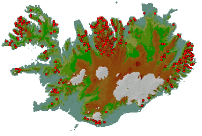
Figure 1. Recorded avalanches that have caused damage or deaths in Iceland.
Leah Tracy
Following catastrophic avalanches in 1995, the Icelandic
Meteorological Office became responsible for reducing avalanche risk to affected
communities. This paper presents the use of GIS in avalanche hazard management efforts
including the construction of an avalanche database, terrain analysis, and risk
evaluation.
Avalanche danger threatens many communities around Iceland. The extent of the danger is indicated in figure 1 showing avalanche events in Iceland (Jóhannesson, in press/b, based on Björnsson, 1980) Historical records document deaths, injuries, and economic damages since the earliest settlements. It has recently been estimated that the direct economic loss due to avalanches and landslides in the last 26 years alone is around 3.8 billion IKR. When the cost of defense structures and relocation is added to the economic loss, the direct cost of avalanches and landslides in Iceland is in excess of 6 billion IKR. If the death of a person in an avalanche or landslide accident is included in the economic loss as 100 million IKR per fatal accident, the total cost of avalanche and landslide accidents in Iceland in the last 26 years together with the cost of avalanche protection measures is more than 13 billion IKR (Jóhannesson, in press/b).
Figure 1. Recorded avalanches that have caused damage or deaths in Iceland.
In 1995, 34 people died in avalanches in the towns of Flateyri and Súđavík in areas that were thought to be safe. Before this catastrophe, avalanche hazard maps had been prepared for several communities, but they were based mainly on recorded avalanches. As settlements expanded up the mountainsides, records of avalanches were scarce. Sadly, lack of records did not equate to lack of danger. The magnitude of the 1995 catastrophe focused attention on the need for new maps based not only on past avalanches, but also on estimated extreme runouts of possible avalanches.
The deaths of so many people were a catalyst for change in how avalanche danger was
addressed in Iceland. The need for a comprehensive national program of land-use planning
with regard to avalanche hazard was identified.
As new information flowed into the IMO, an avalanche database began to form (Magnússon,
1993). Annals documenting the avalanche history of the most severely threatened towns were
compiled and an SQL database was created to organize data and assist in risk calculations
(Arnalds, 1997). Locations, dates, runout lengths, and information about the terrain
together with other metadata were recorded. While this database recorded valuable
information, spatial data was still relatively inaccessible and relegated to notebook
lined shelves.
GIS avalanche database
Prior to the GIS avalanche database, GIS was mainly used to create topographical maps (Magnússon, 1997). In 1997, the Neskaupstađur avalanche annals were published and ArcInfo GIS was used to create some of the avalanche maps in the book (Haraldsdóttir, 1997). Two years later the development of a comprehensive GIS avalanche database began.
The GIS avalanche database consists of spatial information related to avalanches and terrain. It also includes metadata that documents data certainty and links to the SQL avalanche database that stores data sources and other metadata.
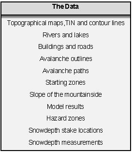
Avalanche Outlines
One of the main purposes of the GIS database is to record avalanche outlines. The outlines come from many sources with varying degrees of certainty. Information about the oldest avalanches is obtained from newspaper articles, interviews, books, and town records. While some points along the outline may be certain (i.e. when the avalanche damages a structure), most outlines of the oldest avalanches must be estimated from the available evidence.
Many outlines of recent avalanches are more certain than the oldest ones. The shape of the tongue may be sketched on a map or a number of witnesses agree on the extent. As with the other avalanches, the tongue of the avalanche is usually more certain than the starting zone or track.
The highest level of certainty is given to some of the most recent avalanches. Snow observers in avalanche prone communities photograph and measure significant avalanches. Sections of avalanches measured with GPS are designated with the highest level of certainty though dangerous conditions and inclement weather can prevent such accurate measurements of an entire avalanche.
The certainty of avalanches outlines are shown graphically through the use of varying line types as shown in Figure 2. As indicated above, a single avalanche outline can consist of segments of varying uncertainty and the certainty is often related to location on the mountainside.
Not only are outlines often uncertain, the date of the avalanche is also uncertain. The SQL database addresses the extent of date uncertainty (Arnalds, 1997), but in the GIS database, 3 dates are assigned: a Julian date, an Icelandic date as text, and an English date as text. While the text dates are used as labels, the Julian date is stored in the internal format of the SQL or GIS database centered in the time interval when the avalanche is known to have occurred. For example, an avalanche known to have occurred in January 1945 is given the date 15.01.1945. Because at times the most accurate possible date is "the late 1700's," the Julian date is purely for query purposes and facilitates mapping date ranges.
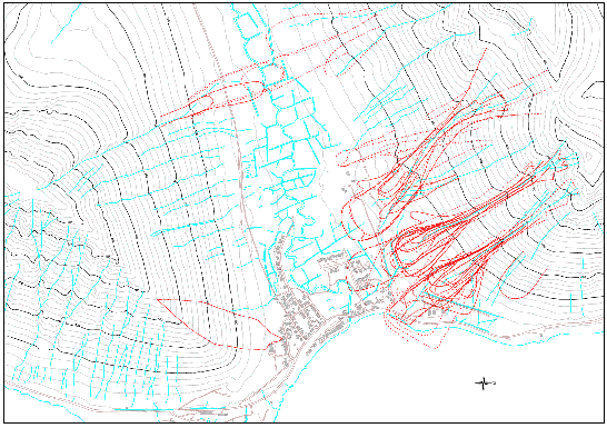
Figure 2. Avalanche outlines of varying certainty in Hnífsdalur, northwest Iceland.
Terrain analysis with GIS
The slope of the hillside is directly related to the possibility of avalanches. If the hillside is very steep, snow cannot accumulate. If the slope of the hillside is too small, snow can accumulate, but will not fall. Using TIN or contour lines to create a grid, a slope map can be calculated as shown in Figure 3. Areas of yellow and purple indicate the extreme slopes where avalanche triggering is unlikely. The increasing shades of red point to the areas where the slope of the hillside could allow the triggering of avalanches. The results of such maps are twofold. It suggests areas to focus field research, and shows potentially dangerous areas on the hillside through color to those unfamiliar with contour maps.
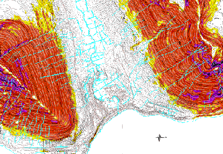
Figure 3. Slope map indicating starting zones in Hnífsdalur, northwest Iceland.
Fieldwork and model results
Avalanche outlines comprise only a small amount of collected spatial data. GIS layers also store results of model calculations, fieldwork and hazard zoning.
Some models demand an estimate of the mass of the snow in the starting zone. Figure 4 shows an example of starting zones. While slope maps can point to potential starting zones, the polygons in figure 4 are based on extensive fieldwork by avalanche experts with consideration of terrain and meteorological conditions. These zones indicate areas where snow is likely to accumulate on the mountainside. Using snow depth measurements and the area of the polygons, the volume and mass of snow in the starting zone can be estimated.
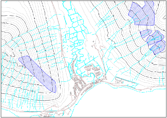
Figure 4. Starting zones in Hnífsdalur, northwest Iceland.
As shown in the 1995 disasters, maps of previous avalanches are not sufficient to determine the extent of avalanche hazard. It is also necessary to estimate extreme possible runouts through the use of models such as so-called runout indices shown in figure 5 (Jónasson, 1997) and the a/b-model in figure 6 (Jóhannesson, 1999). Most models are one-dimensional and require a set of paths as shown in the previous figures. Each path suggests the course an avalanche could trace down the hillside. A starting point, reference point, and name are attached to each path.
The model results are stored as layers in GIS and indicate the size and length of avalanches that could occur along the various paths. These results combined with avalanche outlines form the main inputs to the delineation of hazard zones.
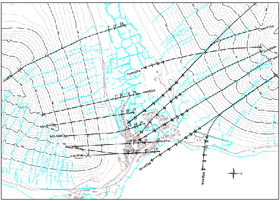
Figure 5. Runout indices in Hnífsdalur, northwest Iceland.
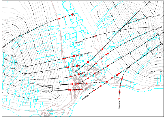
Figure 6. a/b -model results in
Hnífsdalur, northwest Iceland.
Hazard zoning
While models and historical avalanche maps can indicate the location of hazardous
areas, the level of risk that a
community is willing to accept is a political issue. In Iceland, risk is defined by the
probability of death due to avalanches (Jónasson and others, 1999). Zoning decisions are
based on acceptable risk levels that have recently been formalized by law and regulation.
Although hazard zones are not calculated within GIS, they are stored as layers and easily
mapped
Future plans
The database will expand to include more than the current few communities. New avalanches will be added consistently as they occur and automated annals updates will be a feature. Spatial data such as snow depth measurements will be added. Geological maps and aerial photographs should also be included when possible with the goal of increasing accessibility to all available information. Applications will be written to access the precipitation stations and estimate snow accumulation. These layers and grids will in the future be incorporated into an application to assist hazard monitoring and evacuation decisions.
GIS and the community
As length of time following a catastrophe increases so does the tendency to relax. A natural resistance can form to changes demanded by outsiders in a community that has existed for hundreds of years. Following the 1995 accident in Flateyri, it was decided that a huge earthen structure would be built above the town. At that time, not everyone agreed with the plan, but the map in figure 7 showing the performance of the dam just 2 years after its completion clearly reinforced its value (Jóhannesson, in press/a).
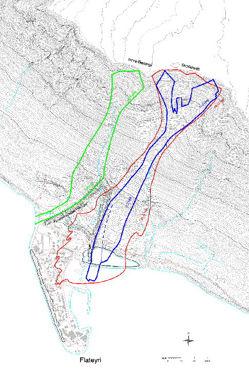
Figure 7. The dams at Flateyri, the catastrophic 1995 avalanche (red), and two avalanches
that have been deflected by the dams since its completion in 1998 (blue and green).
The zoning process is equally controversial. While the risk of avalanche is a great concern, the loss of value in a home located in a new hazard zone is painful. The avalanche hazard label can also be perceived as a slur on a community that struggles to maintain its existence.
As more data becomes available and updated maps are generated, the public should have at least limited access to information. Through GIS and internet, avalanche annals and outlines can be made publicly available while easily updated. By publishing information in this visual and accessible format, the residents of avalanche prone communities can be more aware avalanche hazard and more importantly, be knowledgeably involved in the hazard management process.
Acknowledgements
I thank Tómas Jóhannesson for useful comments.
References
Arnalds, Ţ. 1997. Skipulag tölvutćkra snjóflóđagagna [Organization of
computerized avalanche database]. IMO, VÍ-G97042-ÚR31.
Björnsson, H. 1980. Avalanche activity in Iceland, climatic conditions, and terrain
features. J. Glaciol., 26(94), 13-23.
Haraldsdóttir, S. H. 2000. The effect of avalanche accidents on the recorded avalanche
history and the avalanche work in Iceland.
Jóhannesson, T. 1998. Icelandic avalanche runout models compared with topographical
models used in other countries. In E. Hestnes, ed., 25 Years of Snow Avalanche Research
Voss 12-16 May 1998. Rep. nr. 203, NGI, Oslo.
Jóhannesson, T. in press/a. Run-up of two avalanches on the deflecting dams at Flateyri,
north-western Iceland. A. Glaciol.
Jóhannesson, T. in press/b. Accidents and economic damage due to snow avalanches and
landslides in Iceland. A paper presented at the international LACDE conference in
Reykjavík, 28-30 August 2000.
Jónasson, K., S. Ţ. Sigurđsson and Ţ. Arnalds. 1999. Estimation of avalanche risk.
IMO, VÍ-R99001-ÚR01.
Magnússon, M. M. 1997. Stađan í kortamálum og ArcInfo. Rep. VÍ-G97020-ÚR15, IMO,
Reykjavík.
Magnússon, M. M. and H. B. Baldursdóttir. 1993. A relational database for snow
avalanches. Internal report, IMO, Reykjavík.
Leah Tracy, GIS Manager
Icelandic Meteorological Office
Bustadavegi 9, 150 Reykjavik, ICELAND
tel: +354 522-6000
leah@vedur.is