Author: Kevin P. Hardester
ABSTRACT
Modeled on the Orange County, Florida Geographic Information System, this presentation will guide interested parties through the steps necessary to create a multi-layer, multipurpose GIS through interlocal agreements. The system is built on survey control, ortho-rectified photography, and planimetric data to produce an accurate parcel base using coordinate geometry. This forms the foundation for the delivery of information over the LAN, INTRANET, and INTERNET to office staff, county and city agencies, and the general public. Field data capture utilizes mobile computing with workflow management and workload balancing.
In Orange County, the Property Appraiser’s Office serves as the countywide Project Management Agency for the acquisition of survey control, digital ortho-photography, planimetric data, for development and maintenance of the parcel maps. The Property Appraiser is responsible for the sharing of these databases along with vital appraisal/assessment data over the network(s). The hardware platforms include Microsoft Windows 98, NT workstations and servers, and SunMicrosystems UNIX servers. The overall software system components used are ARC/INFO, ARC/View, MO/IMS, SDE, VB, and Oracle. The spatial accuracy of the GIS is guaranteed plus/minus two feet, with 90 percent of points under 1 foot accuracy. Other agencies add various layers of spatial data and attributes as necessary for specific applications, such as planning and traffic engineering. The major user interfaces are a web browser and a power user customized Arc/View enterprise access program that integrates CAMA and GIS.
The overall steps to be discussed are:
GIS can revolutionize the way government can provide information. "It is the spatial manipulation of cartographic (map) data together with attribute data (additional data about geography, parcels, and other mapped features) that makes geographic information systems unique, i.e. Where is…an object, and What is at…a location." In development of the Orange County GIS system, the aerial photographs, parcel maps, tax roll, and appraisal file data are all related to each other in the same system for seamless access.
There are several ways to implement a multi-purpose GIS system, depending on the goals and objectives of the people who will use the information. However, many government jurisdictions have implemented GIS without understanding all the issues to properly implement the system to serve future as well as current needs. This paper will review the process and procedures that Orange County and the County Property Appraiser set up for a re-engineering of their legacy GIS for a successful multi-user and multi-purpose GIS, using survey accurate GPS points and tying parcel maps to land corners using coordinate geometry. It will go over the essentials of how the project evolved, the development of interlocal agreements, the conversion of existing data, the re-engineering process, and the development of an enterprise desktop access program.
Getting countywide GIS (Geographic Information System) data in the hands of users and the public was once a difficult option in Orange County, Florida. Orange County saw the need to implement what it thought would be enterprise GIS in 1985. The idea that all county agencies could have on-demand access to spatial data and related information was seen as a breakthrough in information processing. The Orange County Board of County Commissioners (BCC) entered into an interlocal agreement with the County Property Appraiser and the City of Orlando to design and implement the system in the late 1980’s. This paper will review a brief history of the events, successes, setbacks, and eventual accomplishment of an enterprise GIS system and the interlocal agreement that was signed in 1999 to re-engineer the parcel base map for real world accuracy.
Orange County, Florida is located in the east central part of the state and is one of the fastest growing counties in the nation. It covers 955 square miles with 330,000 real estate parcels and a population that is approaching 1,000,000. It is a major tourist destination with flights arriving at Orlando International Airport from various domestic and international cities. Disney World, Universal Studios East, and Sea World are the major attractions, as well as being a stepping off point to Florida’s famous beaches. The area has attracted many businesses that want to enjoy the sunny climate and take advantage of affordable living and great recreational spots. Businesses benefit from having the University of Central Florida graduating qualified candidates for a variety of careers. The county has thirteen bustling municipalities, the largest of which is the City of Orlando. Managing this dynamic growing urban and suburban area would require the development of a GIS.
It was upon this background that in 1985 HRD Consulting was hired to develop the original GIS plan. The BCC hired several consultants to work with staff in the planning and implementation stages. In 1988 Baymont Engineering was selected for the conversion of the parcel "base" maps and associated text and annotation. The BCC had also hired survey consultants to densify the geodetic control network to use in tying the property ownership maps to survey control. Problems came up with the survey consultant operation and that part of the project was scrapped. However, the BCC moved forward with Baymont Engineering to convert the parcel maps to digital form. The decision was made to simply digitize the Property Appraiser’s existing paper and mylar parcel maps, and perform rubber sheeting. GEOVISION was purchased as the GIS software of choice.
In 1990 the digitization of the parcel maps was complete and according to the county’s GIS Project Coordinator the street address centerline project was finished in 1992. At that time, when the County’s consultant was asked what was next on the agenda, his response was, "I guess I have to fix the spatial accuracy problems". This answer would prove to be part of the undoing of the GEOVISION GIS system in its maintainability and overall credibility for all agencies. Simply put, the GIS did not tie to real world survey coordinates and could have dimensional inaccuracies of up to 200 feet or more. The base map was a digitized, rubbersheeted copy of existing paper parcel maps. Layers of other spatial data placed on top of the parcel layer would always have to be moved as the parcel data changed over time. This proved to be very frustrating with no resolution to the problem in sight.
Several other problems occurred in 1993. GEOVISION went into receivership and the partnership between the Orange County BCC, the Property Appraiser, and the City of Orlando dissolved. The partners agreed to share data, but it was decided that they would take care of their own GIS needs and staffing. At that time the County’s GIS Project Coordinator’s contract was not renewed and eight consultants were released.
GEOVISION was subsequently purchased by Systemhouse, Inc. and the software was renamed VISION. The BCC and the Property Appraiser continued to use VISION but the enterprise system that was envisioned did not materialize. Converting from VISION’s data format to other formats for user requests proved difficult and requests could not be met. The system at that time did not have a user friendly interface and the BCC and Property Appraiser had to rely on a select few GIS specialists to perform complex programming to accomplish even the simplest of tasks.
In early 1998 the County released a report defining what needed to be done to accomplish the original goals. The following is a short list of remaining tasks:
Fortunately, between 1993 and 1998, the County Surveyor had continued to make progress in establishing a three mile high precision grid of GPS pairs of survey control monuments throughout the county. He also worked to densify a half-mile grid of control points for certified corner records in three townships in the northwest part of the county. This work would prove to be extremely valuable in completing some of the original GIS goals.
In December 1998 the Property Appraiser, with a newly hired Assistant Property Appraiser, GIS Manager, and GIS Analyst, established a new plan to achieve the original goals of developing a true enterprise GIS system. Within the first 45 days a comprehensive plan was established and put into motion that would bring the County, the Property Appraiser, and a number of municipalities into a new interlocal agreement. The plan required the conversion of the old system to Esri’s (Environmental System Research Institute, Inc.) ARC/INFO GIS with SDE (Spatial Data Engine) in an Oracle relational database.
The selected hardware configuration would support a client/server computer network that runs Microsoft’s NT on the desktop and UNIX for the database and file server. Microsoft’s NT was also selected as the ARC/INFO application server for the mappers. A SUN Microsystem 4500 Unix computer was selected as the database server, a DEC Alpha 4100 is currently used for the web server, and a Compaq Proliant 5500 was selected for the map web server. The local area network uses Samba for PC to UNIX connectivity over TCP/IP using 100MB Ethernet connections. The wide area network uses fiber, and the Internet uses a T1 line.
The implementation plan called for developing a user-friendly interface that would allow comprehensive agency and inter-agency access as well as the development of a map Internet for public access. The second part of the plan called for the re-engineering of the parcel layer using survey control and coordinate geometry to depict real world accuracy of the map features. This second part of the plan would be the foundation of all future map feature placement and would eliminate erroneous and redundant work.
The Property Appraiser’s GIS Staff (GIS Manager, two GIS Analysts, and a GIS Operations Technician) established a detailed conversion plan that would include the development of several applications to view and maintain the new system. The conversion process would prove to be an enlightening excursion into database analysis of the VISION system and the design of the new GIS based on Esri’s data format and their Spatial Data Engine stored within an Oracle database. The plan called for using Safe Software, Inc.’s FME software to convert the GIS databases. This was a particularly challenging task and took several weeks of program modifications and intensive conversion reiterations before a completely successful conversion was accomplished.
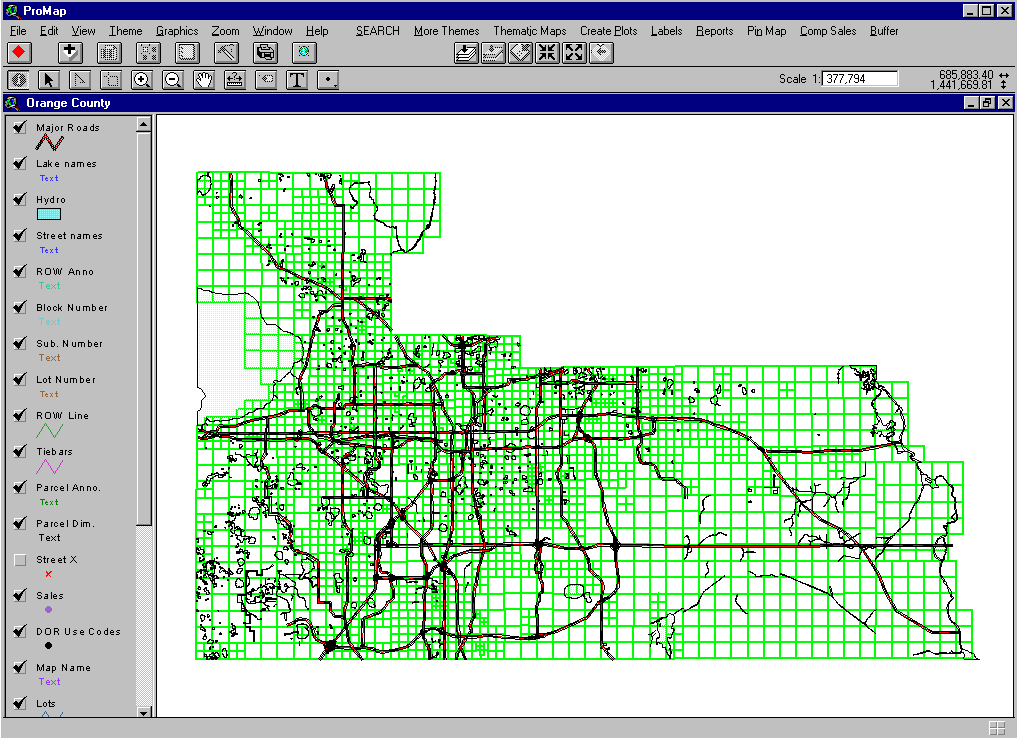
In-house GIS staff was tasked to develop a user friendly, comprehensive enterprise access program to view, query, analyze data, and plot maps. The application, called ProMap (see figure 1), was developed using a customized version of Esri’s ARC/View accessing the SDE database with a connection to a comprehensive list of Oracle tables hosting detail property attributes from the Property Appraiser’s master appraisal and tax roll files. Response time to access the full map extent of Orange County’s 955 square miles averages about 1 to 2 seconds.
ProMap allows access to any and all parcels by several search options. Standard features like pan, zoom in and out, and select map feature options and available by default. You can search properties by owner name, property address, parcel identification number, street intersection, or neighborhood. Other themes, like zoning, future land use, flood plain, and municipal boundaries can be added into the view. Various thematic maps can be created through a pull down menu for assessed values, neighborhoods, land use strata, city codes, sale year, sale to assessed value ratio, and sale price. The program will plot maps at 11" x 17", 25" x 25", 36" x 36", and aerials at 25" x 25". You can automatically label properties with and data elements in the database including parcel numbers, sales data, and subdivision names. Reporting is easy. You can print on-demand mailing lists, export selected parcel data to a spreadsheet or a file. You can create a parcel summary report, a land report and a legal description report for selected parcels. You can also create a pin map from land use codes or from a query. Automatic buffering is a standard feature. You can create buffers around a parcel, line, rectangle, point, circle, or you can create a negative buffer around a circle, polygon, or rectangle. A comparable sales analysis algorithm is available in ProMap. It creates a professional comparable sales analysis and report. This is especially useful in validating assessed values at the Value Adjustment Board and explaining market value to taxpayers and the general public.
Several unexpected benefits were achieved due to the conversion of the spatial database and the development of ProMap. It was recognized that the legacy data did not always adhere to strict standards of mapping consistency for schema, placement of attribute data, and closure of parcel polygons. Much of this was corrected through the conversion quality control programming. This confirmed the need to initiate a formal implementation strategy for consistent schema and data standards to be used in the parcel re-engineering project. An additional benefit was developing closer communication and collaboration with various County agencies and regular office staff in developing an enterprise program that everyone could use. This proved to be extremely productive and opened the lines of communication that had been heretofore limited. And the Director of Appraisal Services recognized the power of ProMap to coordinate with the weekly work packets for each field appraiser to produce the first "routing" program to automatically show the location of properties to be inspected.
We developed a parcel maintenance application, called PAMAP (see figure 2), to maintain the newly converted parcel layer. It was developed using ARC/INFO ODE and Microsoft’s Visual Basic to create a Graphical User Interface (GUI). PAMAP was developed to allow editing of all map features and has a robust COGO (Coordinate Geometry) interface and a connection for a digitizer.
The GIS INTRANET and INTERNET were developed and deployed in December 1999. The INTRANET and INTERNET were developed using Esri’s Map Objects Internet Map Server and Microsoft’s Visual Basic. All employees, local and remote, who are connected to the map server, can access the INTRANET, which provides less functionality than ProMap but more than the Internet program. The INTERNET map application (see figure 3) was developed to allow a very simple user friendly and quick connection to the GIS database with the automatic ability to view more detailed data as the user zooms into a specific area. It was connected to the Property Appraiser’s existing web site (www.ocpafl.org) for integration with the tax roll and appraisal databases. It allows the public to "toggle" back and forth between databases with the click of a mouse button. The INTERNET map application received 22,429 visits and 172,734 requests in the Month of January.
The entire conversion process, which included acquiring Esri’s software products, converting the legacy GIS data, the development of ProMap for enterprise access, PAMAP for parcel maintenance, the INTRANET for quick local government access, and the INTERNET for public access was accomplished within eight months. The entire map extent of Orange County and its associated data can now be accessed in a variety of ways depending on the complexity of the requestor’s needs. Additionally, a special conversion program was written to extract the converted Esri SDE spatial data to five other formats to satisfy public requests for data, which was a major deficiency with the legacy system. These formats are Shape Files, E00 or ARC/INFO Coverages, DXF, MIF, and DGN.
Through interlocal agreements, the Property Appraiser allows government agencies to link directly to the master GIS database and will distribute copies of ProMap for high performance GIS access. Data can also be obtained off line on a CD, and anyone can access the system on the INTERNET. The goal of having a user-friendly enterprise GIS system has finally been realized.
Having accomplished the primary goal, the Property Appraiser set out to accomplish the next goal, which would create a spatially accurate parcel base map with digital ortho-rectified photography and selected planimetric (natural and man made features like edge of pavement). While the conversion to the new GIS was taking place the Property Appraiser proposed an interlocal agreement for the Board of County Commissioners and the various municipalities to participate in the re-engineering of the parcel layer, tying all properties to survey control coordinates using COGO or coordinate geometry and obtaining the ortho-rectified photography and planimetric data. An agreement was finally reached between the BCC and the Property Appraiser in December 1999 to undertake this project. Two cities also signed interlocal agreements with the Property Appraiser and other cities have verbally committed and plan to sign up in 2000-01.
This project deserves special consideration as it is a major GIS undertaking in its own right. It should be noted that there are many ways to implement a multi-purpose GIS system, depending on the goals and objectives of the people who will use the information. However, many government jurisdictions have implemented GIS without understanding all the issues to properly implement the system to serve future as well as current needs. We will now review the process and procedures that the Property Appraiser and the Interlocal partners established through the interlocal agreements for the successful development of a spatially accurate GIS. The Property Appraiser was appointed as the Project Management Agency to acquire and/or develop four products: digital ortho-rectified photography, selected planimetric data, necessary survey control, and creating a seamless and accurate parcel and street map. To this end the interlocal agreements establish the funding sources and set up committees (policy, steering, and technical) to review and monitor the process and provide oversight.
A brief explanation of the necessity of survey control for this project is in order. The State of Florida was originally surveyed based on the rectangular survey system, with the exception of Spanish land grants. The rectangular survey system is a grid of survey lines running east and west (township lines) and north and south (range lines). The lines are specifically numbered. These township and range lines were established in the 1800’s at six-mile intervals, thereby creating a grid of 36 square mile areas. Each township, or 36 square mile area, is further broken down into its surveyed 36 sections or square miles, which again are broken down to quarter and quarter quarter sections. This forms the basis of the land ownership system from which the legal descriptions of real estate are derived.
It should be pointed out that in states, like Florida, that use the rectangular survey system, it is not possible to develop a seamless and accurate parcel base without knowing the coordinate values of the section geodetic control points (see figure 4). Indeed, it is often necessary to locate quarter section control and other points to supplement the real world location of property ownership boundaries. Many local governments have used the process of board digitizing paper maps or scanning maps and performing digitizing on computer screens. However, you have to evaluate the product going into the conversion process as well as the conversion process itself to fully evaluate the quality and accuracy of the final product. You also have to evaluate the expected uses of the final product. The accuracy of the geometry and legal descriptions must be referenced to the geodetic control in order to validate the positional accuracy in the real world. If this is not the case you will create a "floating" map with relative accuracy, and that relative accuracy can vary greatly. If a GIS system is built on the "floating" map concept then any layer or theme that is developed, like land use or transportation, will have constant problems overlaying properly on top of each other since they are not based on the same geodetic foundation.
In a "floating" map the dimensions of the parcel or other lines will not accurately reflect the surveyed boundaries of those features. Using accurate GPS to capture data in the field will also be problematic, as the coordinates will not place the features where they should be in a map not based on survey control. Good planimetric data and digital ortho-rectified photography can assist in the placement process but the geodetic control coordinates, along with the surveyed property ownership geometry is the most important feature for geometric accurate placement of parcel data (see figure 5).
Therefore, even though Orange County now has an enterprise GIS , in order to have a spatially accurate GIS that can be fully utilized, it is necessary to re-engineer the parcel layer. To accomplish the project you must have adequate funding, professional management and personnel resources, technical expertise, and commitment from top management. The interlocal agreements must established the funding mechanism, organizational structure, project management responsibility, time line, and specific products and deliverables.
The BCC and the Property Appraiser would provide funding for the entire project, with any municipal participation to offset the costs. The overall cost would be 9.5 million dollars spread over five to six years. The interlocal agreement calls for the Property Appraiser to focus on approximately 200 square miles a year to re-engineer. As each square mile is re-engineered it would replace the old parcel data in the enterprise GIS database. All other agencies would adjust their "layers" to adhere to the survey control points supplied to the Property Appraiser.
To accomplish this the Property Appraiser is tasked with several steps. The Property Appraiser would secure the services of a Photogrammetric Company to obtain the ortho-rectified photography and selected planimetric data. The Property Appraiser would also have to secure the services of a survey company to locate all of the section and quarter section control points and obtain state plane coordinates on those points for input into the GIS. The County Surveyor would act as the Property Appraiser’s agent in coordinating with the survey firm and the Property Appraiser’s GIS Manager. The Property Appraiser would have to hire eight contract-mapping personnel to create the re-engineered parcel data. The contract mappers would consist of two professional licensed surveyors, four cartographers, and two annotation or data entry personnel. Each municipal interlocal partner would also supply one mapper. An assembly line approach would be set up for the re-engineering process. A senior staff cartographer would assist in supervising the contract mappers. Each stage of the digital re-engineering process will be quality controlled before it moves along the "assembly" line. The ortho-rectified photography, planimetric data, and re-engineered parcel data would then be inserted into the enterprise GIS and replace the old information on an as-completed basis. The distinction between re-engineered and non re-engineered data would be noted.
An important by-product of this project would be to fulfill a long awaited goal of the County Surveyor. Over the past twelve years he was able to create a three-mile high precision grid of GPS pairs covering the entire county. However, the task to locate all certified land corners had been going slow, and on an as needed basis. To date he was able to locate and obtain state plane coordinates on approximately three townships, or 108 square miles. This is only one ninth of the county. With the interlocal agreement between the Property Appraiser and the BCC the process would now be put on a fast track. Approximately 200 square miles would be surveyed annually. Where certified corner records are not available, the best evidence of the corner would be obtained in the field and used as appropriate in the re-engineering process. When geodetic control for land corners or best evidence is not available (lakes, swamps, etc.) then the surveyors would obtain control points from the nearest subdivision or right-of-ways. When the project is completed the Orange County Surveyor’s Office would have a comprehensive listing of certified corner records and their coordinate values. All future proposed plats could then be required to tie into the control network and submit digital data that would drop into the enterprise system where it should. This would also speed up the development review process.
One of the most technically challenging aspects of the project is placing the subdivisions and parcel boundaries using state plane coordinates on geodetic reference points. It is one thing to write a separate legal description or to survey one lot or subdivision, with bearings, angles, and distances without regard as to the real world fit of that boundary into the larger map picture, and quite another challenge to accurately place that boundary into the larger map puzzle. Often there are overlaps and gaps that need to be reconciled. Decisions need to be made based on original intent, errors in legal descriptions, and insufficient or erroneous survey information. These decisions require good judgement and common sense together with the expertise in mapping real world parcel data. A consistent set of standards and procedures must be adhered to in making these decisions, as well as providing research to realize justified solutions.
The survey crews must locate the best evidence found in the vicinity of the section and quarter section corners where certified corner records do not exist. At times they will find several markers in close proximity to each other. This requires the Property Appraiser’s re-engineering team to check out the points in relation to the legal descriptions and plats, thereby verifying the one(s) which provide the best fit in relation to placement of surrounding properties. It can also be challenging for the survey crews to obtain permission to enter properties. Of course there are times when no corner evidence exists (lakes), or the corner no longer exists (taken out due to construction). In these cases we will require the survey crews to locate points on the nearest subdivision(s) for retrofitting corners for section placement, while referring to adjoining sections for verification of a quality controlled fit.
The most challenging, yet satisfying, organizational issue is to bring different agencies and political entities together to create a united front to obtain the funding and support for the project. The first three interlocal agreements took a year to accomplish. This has created a great deal of enthusiasm within the public and private sector in being able to provide a much needed comprehensive, yet easy to use, GIS.
In summary, the success of the new enterprise GIS, and the parcel re-engineering project, is based on the fact that it all works in its most practical sense for local government and for the public. As with any high profile project you must demonstrate that you can deliver on time and within budget. The first project, the creation of a user-friendly enterprise GIS, was accomplished in eight months. The success of the conversion established the overall credibility and leadership for the Property Appraiser and focused on the need for a spatially accurate system. Project deliverables are kept on schedule, with specific delivery items that are of immediate use. Through the interlocal agreements, acquisition of digital ortho-rectified photography and planimetric data for the re-engineering of the parcel layer, data redundancy and labor overhead will be eliminated.
The next step in the evolution of the GIS is underway to establish the County Property Appraiser’s GIS department as the custodian of the countywide GIS data from all departments, as well as being the management agency for developing and administering data standards. The County’s Information Systems and Services department will be the management agency to coordinate hardware and software applications and application standards. These two agencies will co-chair the various committees to oversee the coordination and efficient use of this technology that has started to revolutionize the way government is doing its business in Orange County, Florida.
Figure 1. Initial ProMap Screen
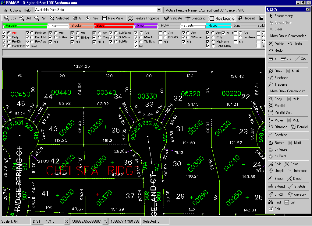
Figure 2. PAMAP (Parcel Maintenance Screen)
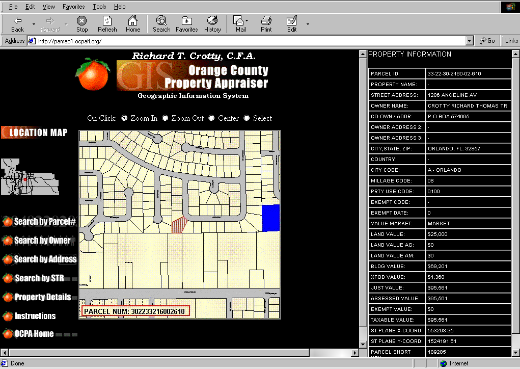
Figure 3. Internet Map Screen
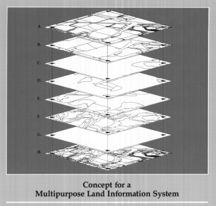
Figure 5. Accurate Parcel Data
Author Information:
Kevin P. Hardester
Assitant Orange County Property Appraiser
Orange County Property Appraiser's Office
200 South Orange Avenue, Suite 1700
Orlando, Florida 32801
(407) 836 5072
khardeseter@ocpafl.org