Annotation and Line Issues
Primary Author – Patrick Noonan
Secondary Author – Dominick Cisson
A historic challenge experienced with GIS data management comes from using source data inputs that differ from the native GIS format. One such input is CAD drawing data. This is typically provided to city/county engineering, planning, and/or GIS agencies by surveyors, architects, and engineers involved in new subdivision, construction plan, and as-built drawing work. To assist those responsible for incorporating this disparate data into GIS and to ensure easier data translation, more emphasis is being put on creating and implementing standards for the way CAD data is submitted digitally.
However, experience shows that digital submittal standards are often difficult to implement for reasons that are technical and cultural — as well as political. Based on our own project experiences, this paper will explore this challenge and some of the difficulties with this process, and it will offer insights that might assist others who are considering implementing digital submittal standards in hopes of streamlining their GIS data maintenance activities.
Digital submittal standards can be thought of as a documented set of guidelines to specify the way data from an external source is to be delivered so that the contents may be more easily accessed, reviewed, interpreted, analyzed and manipulated by the recipient. Digital submittal standards are useful when receiving abundant volumes of digital data from multiple entities such as other internal departments, government agencies, engineering firms, architects or land surveyors. In Geographic Information System (GIS) data maintenance, the source data provided may have graphic features and other attributes that could be used as source inputs for updating cadastral and utility infrastructure layers in the GIS. Ideally, the data is available already in a GIS format, but often it is available in only a Computer-Aided Design (CAD) system format such as AutoCAD (DWG, DXF) or MicroStation (DGN). This paper’s focus is on highlighting the challenges in implementing digital standards for the purpose of converting or translating the data from CAD (AutoCAD) to GIS (Esri) to support more efficient data maintenance, with an emphasis placed on land development.
From our experience working with local government clients across the country, we have captured what we believe to be some of the more common issues an organization is likely to encounter when trying to implement digital submittal standards. Our intention is to provide others with insight into the challenges they may face so that they may be better prepared to overcome later obstacles that can often undermine these types of initiatives. For reading ease, we have organized our findings into categories based on whether the issues are political, cultural/process-related or technical in nature.
The engineering/surveying community is often leery of digital submittal standards because of the extra time they may need to spend on constructing templates, mapping layers, working in unfamiliar geographic coordinate space, etc., and all for what might amount to a small volume of work depending on how much business they do with local government agencies. Ideas to help build support for digital submittals include:
Make drawing templates available — Engineering/surveying firms often have custom templates they prefer using. To encourage the use of the digital standard, a blank drawing template could be developed and made readily available, perhaps even over the Internet.
Support from one department for digital standards may sound like more work to another. Different parts of the organization may be at different places regarding technology, and all must be taken into consideration. Some of the advantages for digital submittals that can be articulated to encourage support include:
The rigidity of digital submittal standards can vary. A rigid standard might specify CAD layer names and color; differentiate between existing and proposed features; dictate CAD file naming conventions, acceptable CAD file formats and coordinate space; require three or more geodetic control points and require associated attribute information to be included in a prescribed data format. The primary advantage of a rigid standard is that it increases the predictability of the document input being received, simplifying the design of a translator for migrating the data into GIS. The other advantage is that it reduces the amount of preprocessing that would have to occur to prepare the data for translation into GIS. The disadvantages include increased difficulty generating acceptance and the temptation to allow different degrees of conformity to slip through as acceptable, negating the primary advantages listed earlier.
A less rigid standard may only require CAD layer names differentiated by primary theme (Sewer_XXX, Water_XXX, Land_XXX, etc.), specific geographic coordinates and three geodetic control points or simply require an electronic file. The advantage of such a relaxed standard is that the engineering/surveying community and others may be less resistant, leading to a higher percentage of standard-conforming submittals. Disadvantages are the increased processing time that must be spent preparing the data for translation and an increased likelihood for error. At some point, it makes more sense to use (digitize or scan) the hard copy submittals for updates, rather than strain to make sense of all the layers and features in the different CAD files.
A phased approach whereby the complexity and rigidity of the digital standard is increased gradually over time, or establishing a pilot or trial implementation with a select group of willing participants before rolling out the standard to the rest of the community may mitigate some of the risks discussed above.
One of the more difficult challenges facing an organization when implementing digital submittal standards is the internal transition in workflow processes that must occur to support a digital versus manual set of drawings. Work processes designed for hard copy submittals are typically not well suited for those submitted digitally. For example, processes for creating mylar transparencies for overlay comparisons with other data, hard copy mark-ups and distributing copies by mail would be replaced by performing reviews on screen, electronic redlining and electronic distribution. Without advanced planning, there will be room for interpretation of what these new processes mean by staff involved, leading to decreased efficiency and resistance. One suggestion is to develop a workflow diagram of the intended new work processes for all to see.
One other potential area of trouble is in trying to support both digital and hard copy submittals with both new and old processes. This can occur when exceptions are allowed for accepting either digital or hard copy submittals or in organizations where staff are resistant to change. Experience shows that trying to support both processes is actually less efficient than supporting one or the other. Some firms in the engineering/surveying community may experience greater difficulty than others adopting the digital standards, particularly smaller, resource-constrained firms that may not own CAD software licenses. If exceptions must be made to allow both, one suggestion could be to streamline the workflow so that either media is processed digitally as early in the process as feasible. This can be accomplished by scanning (and then registering to geographic coordinates) hard copy submittals and treating them as digital through the rest of the workflow.
Depending on the rigidity of the employed standard, there may be either a little (more rigid standard) or a lot (less rigid standard) of preprocessing necessary before the data can be used to update the GIS data. Depending on the individuals involved, there may be a preference for doing these tasks in either CAD or GIS environments, however, in our opinion, AutoCAD is better suited for preprocessing editing. When drawings are submitted in CAD format, any questions directed to the author can be discussed on common ground. Given that AutoCAD’s strength is its drafting functionality, it makes sense to perform preprocess editing in CAD for maximum efficiency. To edit in GIS, selected layers are pulled from the AutoCAD DXF file and built as coverages in ArcInfo (DXFARC command). Once in ArcInfo any number of editing tools and environments can be used to clean up the data before its eventual integration with the existing GIS data. (See the following technical discussion for more about preprocessing AutoCAD data.
There are many logistical hurdles to overcome to migrate CAD-based data into an ArcInfo coverage or geodatabase format. Some hurdles are obvious. CAD data in general comes without attribution, has no intrinsic topology and is often not in real-world coordinates.
CAD file attribution is rarely, if ever, employed by land surveyors simply because the end product, a subdivision or lot split plat, doesn’t require it. Setting up attribution in a CAD file is not a simple matter, and is generally avoided by most surveying firms. Most pertinent land information such as zoning, ownership or parcel numbers are unknown to the surveyor or unassigned until after the digital document has left the engineering firm and been recorded.
CAD files generally lack topology. This is not a difficult issue for ArcInfo, which can rebuild topology. It is an issue in the sense that, without topologic rules in the CAD world, there are no guarantees that imported CAD data will be free of gaps or dangles. These errors are best corrected after importation of CAD data, as most CAD tools have little or no functionality to highlight topologic errors.
Although some engineering firms are beginning to make better use of Global Positioning System (GPS) data to tie their digital plats to real-world coordinates, the vast majority still do not. Most digital documents are delivered in “model space” with the lower-left hand corner of the document arbitrarily set to 0,0. Such documents must be moved and often rotated to fit into the cadastral fabric.
Most cadastral layers are “best fit” to known control points and orthophotography. This is necessary to produce a seamless fabric across a geographic area. As such, it is rare that a Coordinate Geometry (COGO)-perfect plat will fit into an existing parcel fabric. To maintain the seamless nature of a cadastral layer, either the submitted plat must be fit to the fabric or vice versa. The choice can be made on a case-by-case basis or as a departmental edict.
If the decision is made to fit plat data to existing GIS data, the transformation is often best done in CAD before the translation process. This is because the CAD plat often contains data for many different GIS layers. Once the data is translated, each GIS layer must be fit separately, leading to errors. If the data is fit in CAD beforehand, the same adjustment applies to all features. Standard CAD functionality however does not cover warping a drawing to fit, and a third-party add-on must be used to complete the task. Also, if fitting is to be done in CAD, the existing GIS data must be brought in to fit. This can be done through a GIS extract or a Spatial Database Engine (SDE) CAD client.
Layers are the primary method used in CAD systems to delineate data types. They are also the primary delineation used by ArcInfo for defining the CAD to GIS translation mapping.
The correct use of CAD layers is key to any successful digital submittal process. GIS departments can interpolate many different features from a digital CAD file including: property boundaries, subdivisions, blocks, easements, parcel annotation, survey monuments, rights of way and street centerlines. With the large amount of information available from digital submissions, the use of correct layer names to properly segregate the data in a digital plat is critical for proper translation.
There is an inherent disconnect between the needs of GIS and the needs of CAD when it comes to layers. For GIS, the best possible scenario is for all line work and annotation pertaining to a subset of data (i.e., parcels, subdivisions, street centerlines) to be contained in separate and distinct layers. This is not entirely possible, as many features such as parcels and subdivisions share similar line work. To store an entire set of parcel data and a set of subdivision data as separate layers, data must be duplicated. Another issue is that many surveying firms use add-on COGO packages such as Softdesk to perform their coordinate geometry calculations. These packages implement their own layer-naming standards to store their own data types. The result is a CAD file with upwards of 100 layers, each storing small snippets of cadastral data as it relates to the COGO process, and not necessarily the GIS feature type it represents.
For any digital submittal process to succeed, a standard for layers must be developed and followed by plat submitters. It should be noted that the files submitted under any standard would require a manual QC process. Automated processes can check some characteristics of a digital CAD file, but many items such as placement of lines on the proper layers must be checked manually.
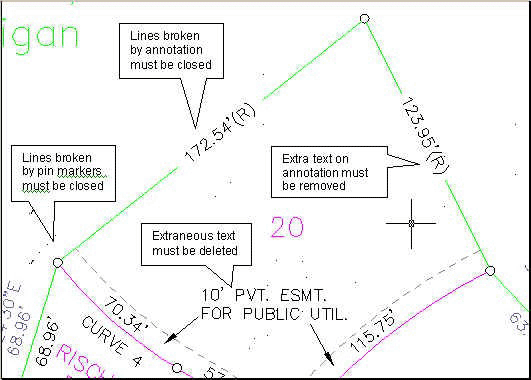
A primary goal of a land surveyor when submitting a plat is to ensure that the document is legible, and to a lesser extent, attractive. To accomplish this, CAD technicians often take liberties with digital documents that adversely affect the digital submission of documents. One common artistic enhancement to digital files often employed by surveyors is to break lines where annotation is placed, allowing the cartographer to place more annotation in less space, at the expense of line work. Once the annotation is removed, the line work remains with gaps where the annotation once existed. It is necessary for post-processing to be done to close these gaps before topology can be built.
Another artistic enhancement often employed by CAD technicians is to make use of special markers for set pins and found monuments. In the interest of keeping map display clean, CAD technicians often break lines at the edge of these symbols, leaving gaps much like those left by annotation in the line work. Again, these gaps must be closed before GIS transformation can be completed.
Callout detail boxes also need to be addressed during post-processing. Often, when too much data exists to display the plat scale, the engineering firm will make use of one or more small detail callout drawings to show greater detail. This extra detail must be reincorporated into the main drawing if it is deemed essential to the translation process.
Annotation and Line Issues
A survey document is designed to be interpreted by the human eye, it is not necessary for the CAD technician to define features completely. For example, easements are stored in most GIS databases as polygon features, defining public access easements, utility easements, etc. On a survey plat, however, not all easement boundaries need to be drawn for the human eye to see the complete easement. A ten-foot utility easement along the front of a property is defined as a single line ten feet from the from property line. The mind’s eye sees the easement line and the property line and fills in the rest. If the easement data is pulled out into a separate layer, the resulting data looks like spaghetti, and requires the addition of many lines to be made useful.
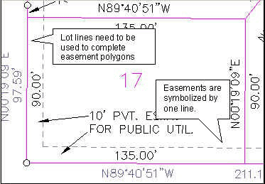
Incomplete Easements
Annotation in CAD files dangles like a carrot for the GIS technician. Often, it is the annotating of newly entered GIS data that requires the greatest amount of editing effort, thus CAD file annotation is of great value. Annotation, however, is not without its pitfalls and issues.
Most GISs have defined standards for annotation sizes regarding dimensions, parcel numbers, subdivisions names, etc. These defined sizes ensure that annotation is legible at a certain scale, and that annotation display is homogenous across the database.
When a CAD technician places annotation on a plat, the primary concern is legibility at the plotted scale of the plat. If the plat has a plat scale of 1” = 50’, the annotation may be five feet tall. If the plat is 1” = 500’, the same annotation will be ten sizes larger. While the annotation looks fine on the platted digital file, it will often not coincide with the annotation sizes defined in the GIS. Annotation can be resized after translation, but due to the typical lower-left justification of CAD annotation, the resized annotation will either scale away from or into the line work it labels. It is up to the GIS technician to manually move the resized annotation for better cartographic quality.
Another issue that requires attention is the need to remove extraneous annotation from the digital plat. Digital plats are designed to convey more information than typically needed in a GIS, and must do it without the use of attribution for information storage. As such, features on a digital plat are typically “over annotated” for GIS purposes. Line work that defines a drainage easement must be labeled as such, whereas in the GIS it can simply be attributed.
Annotation content itself may also need to be edited. Dimensions may contain extra text to define lines as radials, or carry too many decimal places. These require manual fixes in post-processing. Also, CAD annotation leader lines do not translate well into a GIS and should be deleted before conversion. Leader lines that do get converted result in miniature polygons at every arrowhead, and dangling lines elsewhere.
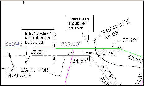
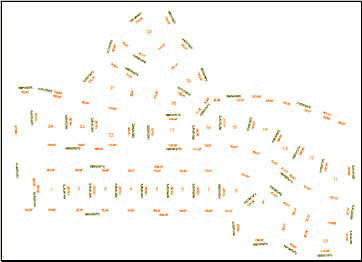
More Annotation Issues
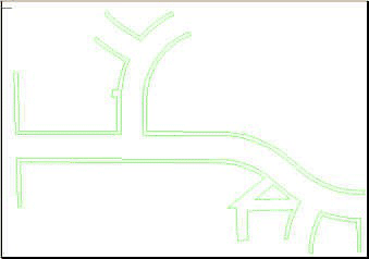
A Typical Digital Plat
Easement Data After Post-Processing
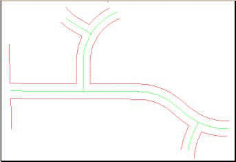
Right-of-Way Lines and Interpolated Centerlines
The implementation of digital submittal standards, while certainly feasible, is not necessarily straightforward and easy. Providing insight into the potential challenges is not intended to dissuade anyone from trying to implement digital submittal standards, but to better communicate these issues so that more organizations will try to implement them. Fortunately, help is available. Organizations with a national perspective on the subject such as the CADD/GIS Technology Center (http://tsc.wes.army.mil/center_info/) are working to create national standards that will remove much of the uncertainty surrounding digital submittals as they become more widely used. Although originally intended to standardize the way U.S. military bases exchanged data, the standards are applicable for others. Hopefully, through the efforts by organizations such as this and the continued sharing of lessons learned by organizations that have been successful, the implementation of digital submittal standards will become more widespread and easier to achieve.
Patrick Noonan
Senior Technical Consultant
6399 S. Fiddler's Green Circle, Suite 600
Greenwood Village, CO 80111
(303) 486-1199 telephone
(303) 741-8401 fax
patrick.noonan@convergentgroup.com
Dominick Cisson
6399 S. Fiddler's Green Circle, Suite 600
Greenwood Village, CO 80111
(303) 741-8417 telephone
(303) 741-8401 fax
dominick.cisson@convergentgroup.com