Tarcisio Coianiz, Paolo Viskanic and Fulvia Gambalonga.
Testing the quality of geographic data is an important step before starting to use it. This is particularly important when importing 3D data from a CAD environment and when linking geographic data to existing municipal alphanumerical databases. The authors have developed automated procedures, which are carried out to check the topology, geometrical and attribute consistency of the data, before importing it into the centralised geodatabase. This paper illustrates the algorithms used and how they are applied using Esri software in the municipalities of South Tyrol, Italy.
South Tyrol is a mountainous region in northern Italy. It is located in the Alps and borders Austria and Switzerland. It covers an area of approximately 740,000 ha ranging from 200 to 4000m in altitude, with a total of 465,000 inhabitants.
The S�dtiroler Gemeindenverband (SGV), i.e. the Association of Municipalities of the region, is developing a centralised Geographic Information System which integrates the municipal master plan, the technical maps (3-dimensional), the cadastral maps and the municipal general register.
The SGV is working on this project in conjunction with the GIS departments of its two main cities-- Bolzano (100,000 inhabitants) and Merano (35,000 inhabitants) as well as with the Land Registry and the Country Authorities
The local governments have made a tremendous effort to build the new 3D technical maps from aero photographic stereo measurements, using a scale of 1:1000. The technical maps are used as basis for building other maps, i.e. the municipal zoning plan, the maps of the networks (water, wastewater, electricity, gas), and to upgrade the cadastral maps. The municipal geographic information system is also based on the same maps.
An important stage in building a geographic information system is the control of the correctness of the information. There are many possible sources of errors in a spatial database. This paper is focused on the analysis of the errors deriving from the original measurements. The goal was to give the municipal administrations a tool for testing the quality of technical maps that had been produced by the specialized companies that they had commissioned.
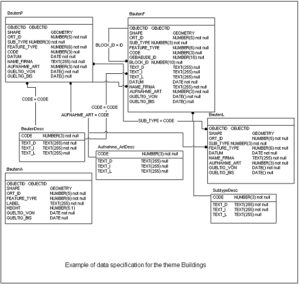
The technical maps are organized in themes and levels. The following themes has been defined:
Hydrography |
Vegetation |
City-planning |
Streets and railways |
Buildings |
Orography |
Roofs |
Networks |
Each theme can be considered as a physical layer and contains homogeneous features, i.e. objects that belong to the same class, according to a given definition [1]
Even though each theme is stored in a shapefile, i.e. a non-topological data structure (arguments for this choice are reported in [2]), a topology on the whole theme-set has nevertheless been defined. To take into account the topology among the themes, logical layers on the data has therefore been introduced, which collect features from the different themes, sharing common properties or relations.
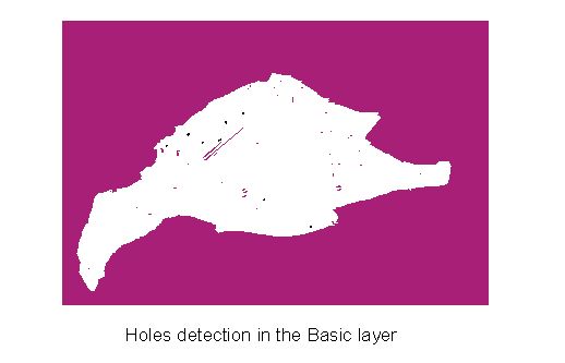
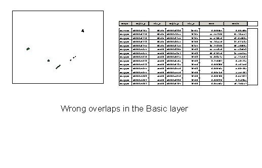
The most important layer, which defines the grounding topology of the data set, is the basic layer. It collects all the objects that assemble a partition of the territory. It means that no holes and no overlaps are allowed among features of this layer. Some important objects of this layer are for example rivers, seas, green areas, streets, railways and buildings. The basic layer is used to update the parcels of the cadastral maps.
Some other layers have been defined, which are overlays of the basic layer and contain either macro aggregation of objects of the basic layer, or further details about them. The overlays layers can coincide with a theme or can be subsets of the themes.
The roofs layer, which coincides with the roofs theme, is an example of the first type. A very simple constraint exists between features of the roofs layer and the basic layer, which is that each roof must have a building beneath.
Another layer, which coincides with a theme, is the city-planning layer. The features in this layer are mainly macro-aggregation of objects of the themes, buildings and vegetation. It is used to give common attributes to the features of a give area (for example industrial area, school area, green area, residential area) and to guide the generalization of the map at lower scales. The constraint in this case is that streets cannot cross objects of this layer.
An example of the second type is the layer of sidewalks: It is a subset of the theme- streets. A sidewalk is defined as an area that lies on a street (it means that the street area beneath includes the sidewalk area), and is viewed as a further detail of the street, like flowerbeds and safety islands, which define another layer on the street. The constraint in this case is that a sidewalk must be entirely contained in a street.
By evaluating the quality of a technical map, on which a geographic information system should be built, two different aspects are important-- the correctness of the geometry and the correctness of the related tabular data.
Each object should have the proper identifier (FEATURE_ID) that characterizes the feature (from a given catalogue).
Each object also has other mandatory attributes.For example the unique municipal key identifier for each street or for each street number.
Each feature also has a unique identifier which distinguishes each object from others of the same type (OBJECTID)
The preliminary control of the data concerns the verification of the presence of all the objects requested in the correct theme, as well as the presence and correctness of the mandatory attributes of each feature. A statistic of the distribution of the features is also made, so that a potential lack of data in some parts of the map can be revealed.
|
The second set of controls concerns the correctness of the content of the tabular data. Of course, a test that guaranties the correctness of the content of an attribute is not possible. It is possible, however, to verify that each attribute satisfies the given rules or constraints. For example we can control that the OBJECTIDs are unique within the set, that street-codes and street-number-codes match the corresponding codes in the municipal general register and that the height of a building (attribute HEIGHT) is within a given range.
The preliminary control on the geometry concerns the geometry type of the features. Of course, not all the geometries (polygon line or point) are allowed for each feature. Detailed specifications are given in this regard. For example, a building should always be a polygon, a street or a river could be a polygon or a line, depending on its width, a pole should always be a point.
The core of the controls of the geometry regards the topology of the basic layer. The objects of this layer define a partition of the territory: the presence of holes or overlaps within objects of this layer is checked.
Finally the topological constraints among the layers are checked. For example, sidewalks must lie entirely on streets, roofs over buildings, street numbers inside a building and so on[1].
All the controls mentioned above are implemented at the moment in ArcView3.2: Avenue scripts have been written for the different stages of the controls, which produce the related reports. This should be considered as a preliminary implementation, waiting to migrate to the novel ArcGis 8 geodatabase structure. The geodatabase model of the entire system is in fact under construction: all the topological constraints inside and among the layers are being implemented as constraints between features of the geodatabase. This is the main project we have been dealing with for the current year.
[1] S�dtiroler Gemeindenverband. "Numerische Kartographie in den Nominalma�st�ben 1:1000 und 1:2000 Technische Einzelheiten". Technical report.
[2] T. Coianiz, F. Gambalonga, P.Viskanic. "Dalla Cartografia Numerica ai Sistemi Informativi Territoriali". Rivista del Dipartimento del Territorio. Tipografia del Genio Civile.
[3] P.Viskanic, T. Coianiz. "GIS in the Local Administration in South Tirol, Italy". In proceeding of the Esri European, Middle Eastern, and African User Conference 2000.
[4] A. M�ller, J. Manegold. "Digitale Gemeindegrundkarte. Objektmodell und �bergabespezifikation". Technical report.
[5] Sellini, F. Guzzetti. "Cartografia Generale". Utet Publisher
[6] "�bertragung der Gemeindekarte Technische Merkmale", Autonome Region Trentino-S�dtirol, Version Nr. 01 Juni 1998
[7] "Objekte der numerischen Technischen Kartographie", Autonome Provinz Bozen - S�dtirol Amt f�r �ber�rtliche Raumordnung (Abt. 27), Ausgabe 19.10.1999
Tarcisio Coianiz
Association of the municipalities of South Tyrol, Italy
Geographic Information Officer
Viale Stazione, 5 - I-39100 Bolzano - Italy
tarcisio.sgv@gvcc.net
Paolo Viskanic
municipality of Merano, Italy
Geographic Information Officer
Via Portici, 192 - I-39012 Merano - Italy
Fulvia Gambalonga
municipality of Bolzano, Italy
Geographic Information Officer
Vicolo Gumer, 7 - I-39100 Bolzano - Italy