Regional Growing Smarter Implementation
Plan and its Influence on Regional Growth
Chris Bruce, Don Worley, Anubhav Bagley, and Rita Walton
Abstract: In 1998, "Growing Smarter" legislation
was passed by the Arizona Legislature requiring cities and towns to create
comprehensive plans for future growth. In response to this legislation,
the Maricopa Association of Governments
is developing a Regional Growing
Smarter Implementation Plan to encourage a consistent regional approach
for future growth and to create strategies and a policy framework to direct
infrastructure development and open space areas. The end results will help
local governments with their own general plan updates and identify necessary
regional policies. GIS applications required to test the impact of growth
strategies upon congestion and transportation systems, other regional infrastructure
needs and costs, schools, and open space will be discussed.
Introduction
The Maricopa Association of Governments serves as the
lead regional planning agency for the metropolitan Phoenix area, which
includes 24 cities, two Indian communities and Maricopa County. As the
designated Metropolitan Planning Organization (MPO) and Council of Governments
(COG) for a region inhabited by over three million people, MAG understands
the crucial responsibility inherent in its role of facilitating decisions
affecting land use, transportation and air quality.
MAG is one of the few agencies responsible not only for
regional transportation planning, but also for land use, air quality, water
quality, solid waste and human services planning. In other metropolitan
areas these responsibilities are usually handled by two or more separate
agencies, making coordination of the planning activities more cumbersome.
MAG has been seeking to improve the performance of its regional land use,
transportation, and air quality models, thereby making the regional
planning process more effective. GIS has played a major role at MAG for
the past twelve years in improving these models. This technology has significantly
enhanced MAG�s ability to manage dozens of planning databases: databases
describing census statistics, employment inventories, land use, general
plans, parcels, building permits, and highway infrastructure. GIS also
helps MAG assume an important responsibility in the region � the role of
a regional information agency for public planning.
Growing Smarter
In 1998, "Growing Smarter" legislation was passed by the
Arizona Legislature requiring cities and towns to plan for future growth
in a way that would enhance the quality of life. In response to this legislation,
MAG applied for and received a Transportation and Community and System
Preservation (TCSP) grant to develop an implementation plan to encourage
a consistent regional approach for future growth and to create strategies
and a policy framework to direct infrastructure development and open space
areas. By 2003, each of the 25 local jurisdictions in Maricopa County is
required to have in place a new general plan developed in conformance with
the Growing Smarter legislation. At a minimum, these plans are required
to incorporate land use and circulation elements. However, as these are
being developed independently, the Maricopa Association of Governments
will closely evaluate the complete regional picture.
The implementation plan currently underway by MAG involves:
enhancing regional planning efforts by collaborating with local governments
on plan updates; gathering the databases necessary to evaluate future development;
and using the databases to run regional models and test the impact of locally
derived plans upon regional congestion and transportation systems,
other regional infrastructure needs and costs, schools, and open space.
The end results of the implementation plan will be two-pronged: first,
to help local governments with their own general plan updates, and second,
to identify regional problems and issues and to suggest necessary regional
policies to address them. MAG will also provide member agencies with "best
practices" reports on local planning issues (1) that should be dealt with
on a consistent basis by all agencies, or (2) by addressing a local issue
that would be better dealt with from a regional perspective.
This paper describes the GIS activities resulting from
the TCSP grant awarded to MAG. The grant was intended to create the basis
for ongoing and more active regional planning and problem solving. GIS
analysis has involved working towards developing methods for (1) understanding
the regional socioeconomic impacts of long-term land use plans being generated
by the member agencies and (2) better appreciating the environmental consequences
of plan implementation.
General Plan Land Use Data
In the past 10 years Maricopa County has grown by almost
1 million people to exceed 3 million residents. MAG�s regional composite
of local land use plans implies a build-out regional population of 13 million
persons � more than 4 times the size of the regional population in 2000.
While each of the 27 local jurisdictions within the county have attempted
to cope with this growth individually, MAG has been seeking to integrate
their efforts into a consistent regional approach through a Smart Growth
Implementation Plan. The twenty-four cities and towns and Maricopa County
in the MAG region are required to amend their General Plans by December
31, 2002 at the latest, to comply with Growing Smarter legislation. MAG
is conducting a review of each of these updated General Plans with the
intent to understand the impact of these plans at a regional scale.
The General Plan Land Use identifies both the type of
development that is anticipated to occur in the future, and the density
of the development. The plan is the vision of the future as seen and developed
by the community. Generally, the plan being provided to MAG for analysis
is comprised of detailed documentation along with a hard copy
of the plan. A number of the communities now also provide the plan in GIS
format. In cases where this electronic version is not made available, MAG
needs to convert the paper copy to a GIS theme.
Each General Plan classifies the land use using a scheme
unique to the member agency. Each of these land use categories are accompanied
with their respective housing or employment densities. Although MAG uses
these densities to perform most regional analysis, we also bring all the
General Plans onto a common land use scheme. MAG has developed regional
standard land use categories, which are utilized to convert the disparate
local land use categories to its regional standard. This often involves
working with the member agencies to develop an equivalency table for this
conversion. Table 1 is an extract of the residential land uses from the
conversion table created for one such member agency.
|
MPA LAND USE DESCRIPTION
|
MPA LU CODE
|
MAG LU CODE
|
MAG LAND USE DESCRIPTION
|
MIN. DU DENSITY
|
MAX. DU DENSITY
|
TARGET. DU DENSITY
|
| 0
to 1 |
10
|
110
|
Rural
Residential |
0.20
|
1.00
|
0.50
|
| 0
to 2 |
12
|
110
|
Rural
Residential |
0.20
|
2.00
|
1.00
|
| 1
to 2 |
20
|
120
|
Estate
Residential |
1.00
|
2.00
|
1.50
|
| 2
to 3.5 |
24
|
130
|
Large
Lot Residential (SF) |
2.00
|
3.50
|
2.80
|
| 5
to 7 |
46
|
140
|
Medium
Lot Residential (SF) |
5.00
|
7.00
|
6.00
|
| 5
to 10 |
48
|
140
|
Medium
Lot Residential (SF) |
5.00
|
10.00
|
8.00
|
| 8
to 10 |
49
|
140
|
Medium
Lot Residential (SF) |
8.00
|
10.00
|
9.00
|
| 10
to 15 |
50
|
150
|
Small
Lot Residential (SF) |
10.00
|
15.00
|
12.00
|
| 15
+ |
53
|
160
|
Very
Small Lot Residential (SF) |
15.00
|
20.00
|
18.00
|
| 20
- 30 |
86
|
180
|
High
Density Residential (MF) |
20.00
|
30.00
|
25.00
|
Table 1: MPA to MAG land use code mapping table
Many jurisdictions have a "mixed use"/ "multiple use"
category in their local land use plan. A "multiple use" category in the
existing use primarily signifies areas being developed with different land
uses. For example, the same building might have retail and office on the
lower levels and high density residential on the upper levels. "Mixed use"
category in the General Plan refers to areas that may have a mix of residential
and employment uses. Mixed use is not only defined differently between
two jurisdictions, it may also be different between two areas within the
same agency. Thus, within the Phoenix General Plan, North Phoenix may be
envisioned to contain a certain mix of office, light industrial, retail,
and residential space, while another mixed-use area in the downtown area
may contain only retail and office. Because mixed use may be defined differently
depending on the jurisdiction, MAG works with its member agencies on a
definition for mixed use that varies by jurisdiction, or even by location
within jurisdictions. Also, to better emulate the land use on ground, a
new linked data structure has been developed. In this structure, there
can be more than one record that describes the contents of a land use polygon,
for each polygon. Land use polygons, therefore can contain residential
(dwelling units), employment (of various types), and special population
group features (motels, mobile homes, etc.). The implication of this data
model is simply that there are no constraints � any land use polygon can
contain anything or any combination of things. It is totally flexible.
Along with the conversion of the land use categories to
the regional standard, the residential densities and floor area ratios
for employment are also converted to MAG standards. While MAG's standard
land use categories define densities and floor area ratios, the land use
categories in the local plans may not always fit into the same categories.
Again, MAG must work with the local jurisdictions to ensure that data is
consistent across the region. It is important to note, that the data structure
used by the socioeconomic model incorporates both the jurisdictional classification
as well as the MAG equivalent values.
Socioeconomic Analysis
MAG utilizes its Sub Area Allocation Model (SAM) to assess
the General Plans from the member agencies. SAM-IM is a rule-based urban
growth model. It simulates both short-term and long-term urbanization of
a region by reacting to any set of factors and conditions that the planner
wishes to express. The model is completely embedded in a GIS � it runs
on ArcView GIS using the Spatial Analyst extension. The concept of the
model is entirely GIS oriented � all of the data that drives the model,
whether it be existing land use distributions, future market conditions,
adopted planned land use, developments already approved and underway, or
local land conditions, are expressed geographically, in the form of ArcView
shape files. Anything that can be expressed geographically can be taken
into consideration in the model.
SAM forecasts and analyzes land use and development throughout
the MAG planning region. It does this by simulating factors that influence
the likelihood that land will be built, based on those factors. It observes
planning policies � general plan designations controlling the use of land
(approved by municipalities in the region), for example, are observed by
the model.
Once the General Plan data issues are resolved, the updated
General Plans can then input local land use data into SAM-IM to assess
the impact of these local plans on regional issues. Different build out
scenarios are created to assess how the local vision of the future would
affect the region as a whole. The scenarios include high, medium, and low
intensity growth options. Also, complete or selected redevelopment may
also be modeled. Comparisons are drawn between the General Plan and the
socioeconomic projections in terms of population growth, employment areas
and accessibility of employment from residences. The build out generated
from the General Plan is also assessed against how well it ties into the
complete region. It should be noted that since SAM models growth at a 1-acre
grid level, the build out model results can be analyzed at any geography
including Census Tracts, Traffic Analysis Zones, Regional Analysis Zones,
or other local boundaries that can be translated to a spatial coverage.
Another important factor that is assessed is the ratio
of jobs available in an area to the resident households in the area. This
job/housing balance is one indication of the extent of travel
required in an area. It is important in specifying a General Plan to ensure
that the residential growth in an area is balanced by appropriate employment
and conversely, that employees have appropriate housing options near where
they work. This information also becomes a part of the analysis of transportation,
school, and water infrastructure requirements in an area.
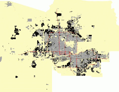
The SAM-IM simulation generated this forecast scenario of growth and
development in Maricopa County over the next 20 years. Shown in gray
are existing "built" uses (in 1995). Shown in black are new developments
projected to occur by the year 2020.
(The proposed 2020 freeway system is also shown).
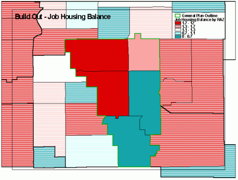
Build out and Job-Housing Balance analysis for the
Town of Gilbert General Plan
The average density of jobs planned in an area is also
an important indicator for sustainability of the Plan. This analysis is
conducted at the Grid level using scripts in SAM. It is possible to calculate
the job density for each cell averaged over a specified radius. These maps
become part of the General Plan analysis done for the jurisdiction in their
review of their General Plan.
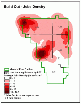
Average Job Density Analysis conducted using SAM for
Build out
Environmentally Sensitive Development Areas
The MAG Regional Open Space Plan, Desert Spaces was adopted
in 1995. This plan is a guide for MAG member agencies to protect sensitive
open spaces while allowing future growth and development. The plan is for
an integrated regional open space system. In addition to areas identified
for conservation and policies for linkage, one element identifies public
and private lands with high open space value, and recommends that sensitive
development regulations be used in these areas. In June 2000, MAG also
adopted the Environmentally Sensitive Desert Areas Policies and Design
Guidelines recommending restrictions on new growth in environmentally sensitive
areas.
As part of the Growing Smarter Implementation Plan, MAG
is reviewing local land use plans for their impact on open space. In areas
where environmentally sensitive development regulations are recommended,
there are six development standards that are based on a land cover classification
(LCC) system. In the LCC system, there are two vegetation categories: upper
Sonoran and lower Sonoran. Within each vegetation category, LCC types are
further categorized by slope. LCC types 1, 2, and 3 fall within lower Sonoran
vegetation and have slopes of 0-3 percent, 3-6 percent, and greater than
6 percent, respectively. LCC types 4, 5, and 6 fall within upper Sonoran
vegetation and are categorized similarly by slope.
MAG obtained elevation lattices for the region from the
Arizona State Land Department and developed a GIS data set of the LCC types
by deriving slope from these lattices and combining slope and vegetation
type with the Desert Spaces Plan data. As local land use plans come in
for review, MAG can then overlay GIS coverages of these plans with the
LCC type data. Standard map templates have been created that allow MAG
GIS staff to easily create context maps that show how these local land
use plans relate to regional environmentally sensitive development areas
and open space. MAG can also analyze and report the acreage of environmentally
sensitive development areas that are within the various land uses designated
by the local jurisdiction.
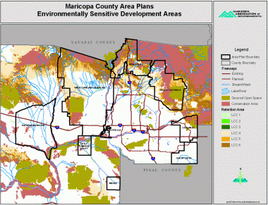
Environmentally sensitive areas analysis for the County.
MAG�s Desert Spaces Plan, Vegetation data, and slope
derived from DEM were
used for the analysis.
|
General Plan Review: Area within Environmentally Sensitive Lands |
|
|
|
DRAFT |
|
|
|
| Conservation
Area: |
|
|
|
|
|
|
Category
|
Acres
|
|
|
|
|
| Residential |
3,150
|
|
|
|
|
| Commercial/Office |
440
|
|
|
|
|
| Industrial/Commerce
Park |
790
|
|
|
|
|
| Public/Quasi-Public |
400
|
|
|
|
|
| Mixed
Use |
310
|
|
|
|
|
| Undesignated |
420
|
|
|
|
|
| Parks/Open
Space/Water |
11,600
|
|
|
|
|
|
TOTAL
|
17,110
|
|
|
|
|
|
|
|
|
|
|
| Retention
Area (LCC 4): |
|
|
|
|
|
|
Category
|
Acres
|
|
|
|
|
| Residential |
20,620
|
|
|
|
|
| Commercial/Office |
910
|
|
|
|
|
| Industrial/Commerce
Park |
1,510
|
|
Note:
LCC 4 is Retention Areas |
| Public/Quasi-Public |
850
|
|
in
Upper Sonoran Vegetation |
| Mixed
Use |
2,810
|
|
with
0 - 3% slope. |
|
| Undesignated |
3,860
|
|
|
|
|
| Parks/Open
Space/Water |
17,020
|
|
|
|
|
|
TOTAL
|
47,580
|
|
|
|
|
Sample components of analysis report for General Plan
ESDA analysis
Future Developments
Research has been done into fully automating this mapping and analysis,
however there are issues that have prevented full automation thus far.
One such issue is local data format. If MAG does receive local land use
plan data in digital form, it may come in formats ranging from ArcInfo
export files to ArcView shape files, to CAD files. Once the data is successfully
imported into MAG's GIS, the land use type field name is not consistent,
and land use types are not consistent from jurisdiction to jurisdiction.
Because of these issues, review of local land use plans from a GIS perspective
is still largely a time-intensive process. MAG will ensure all data and
GIS coverages derived for and from this process will be made available
to the member agencies, with the goal of ensuring consistent databases
in the future.