Development of framework data has taken center stage in the United States at both National and local levels. Conceptually, we are striving to develop seamless data that is both current and accurate. Overall standards provide the basis for defining the structure and characteristics of these data themes. Development and maintenance of the data at the local level provide opportunities to include the most current and accurate information.
Hydrology represents one group of framework data themes. These themes include the watershed boundary dataset (WBD), the National Elevation Dataset (NED), and the National Hydrology Dataset (NHD). This group of data is intended to work together to provide a firm basis for hydrologic analysis and modeling.
Efforts in California to develop a watershed base map illustrate several issues to be addressed for local development of framework data.
Introduction - Framework Data - Watershed Boundary Dataset
California has been involved in the process of developing a database of watershed boundaries for over five years titled CalWater. This effort has involved both Federal and State agencies. CalWater Version 2.2 (IWMC, 2000) was released in 1999 for use by these agencies. Local governments and watershed groups have also expressed interest in further definition of watersheds at the local level. Watershed boundaries have also been identified as National framework data. This is the Watershed Boundary Dataset (WBD).Guidelines have been released as Standards for Delineation of Watersheds (NRCS, 2001) to assist in this development.
This is an ideal time to coordinate these efforts to develop a uniform and consistent watershed boundary database for California. Such a database could meet local and state needs as well as merge into a seamless National database. However, completing a watershed database in a timely manner for the framework database and maintaining information needed at the local and regional level has some fuzzy issues. These issues include:
- Adjustment of features that may exist in the National database to properly reflect local conditions.
- Identification of features to be carried into the framework database and those that need to reside at the local level.
- Requirements for defining and representing features and attributes for the National database that are different than local requirements.
- Custodial issues of data and source record maintenance and updates particularly where adjustments are required for the National database.
- Logical consistency in representing features and defining attributes.
- Completeness in feature representation.
For California, these are issues to be addressed not only for development of the watershed boundary dataset, but also for the involvement of local government and watershed organizations in the CalWater effort. These issues also have implications for the development and maintenance of other framework databases.
The National Watershed Boundary Dataset
Federal land and resource management activities and planning efforts are required to be developed and reported on a watershed basis (Federal Register, 2000). The National Watershed Boundary Dataset (WBD) is intended to provide the primary boundaries for Federal agencies. This has placed increased emphasis by Federal agencies in the development, review, and adoption of WBD. Federal Standards for Delineation of Hydrologic Unit Boundaries has been released (NRCS, 2001). It contains requirements for development and verification of watershed boundaries into WBD. It includes:
- Guidelines for delineation of watersheds,
- Requirements for identifying the various units,
- Definition of the database structure,
- Naming conventions,
- Requirements for documentation and the disposition of source records.
Conceptual Model
Conceptually, this seamless database will consist of watersheds defined by hydrologic conditions. The typical watersheds are areas where all surface waters drain to a single point representing the outlet point for a stream or river. WBD is based on hierarchical hydrologic unit code (HUC) data developed by the U.S. Geological Survey (USGS) during the 1970's. This database recognized four levels in the hierarchy for identifying watersheds.
- Regions
- Sub-regions
- Accounting Units
- Cataloging Units
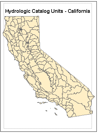
WBD will contain two additional units identified as watersheds and sub-watersheds. These will be developed with a target resolution of 1:24,000. Within the cataloging units, watersheds will be identified with further refinement into sub-watersheds. Figure 1 shows existing Federally recognized watershed units for California down to the USGS cataloging unit.
The WBD is one of three primary hydrology databases. The others are the National Hydrology Dataset (NHD), and the National Elevation Dataset (NED) as modified for hydrologic applications. These databases are designed to be able to work together. The surface water network identified in NHD should have all stream segments falling within a watershed unit identified in WBD. NHD has been initially released based on conflation of information contained in the Environmental Protection Agencies RF-3 data. The initial scale of this data is 1: 100,000. It is progressively being updated to a 1:24,000 target scale. These updates are being done where possible on a cataloging unit (HUC) basis. NED should consistently generate similar watershed areas to WBD when the same outlets or pour points are selected. NED data is progressively being updated from a resolution of approximately 30 meters to a 10 meter resolution for surface elevation values.
The Standard for Delineation of Hydrologic Unit Boundaries is one of the Federal standards which provides considerable flexibility for the development of watershed boundaries by each State. This includes modifying existing cataloging units. The guidelines recognize that some catalog unit boundaries have an extensive history of use and application including legal recognition. Modification to these boundaries may be made to reflect actual hydrologic conditions. The guidelines recognize that in defining watershed boundaries several special cases exist.
Remnant Areas
Small areas around larger streams are expected to occur that do not fit within adjacent watersheds.
Non-contributing Areas or Areas with No Outlet
Areas that represent an internal drainage area that has no outlet such as the Great Salt Lake, playas, and enclosed basins are recognized.
Large Water Bodies and Coastal Areas
Where possible, the guidelines provide for defining the watershed by ignoring the water surface and using the drowned river channel or to the toe of the submerged shore face. For lakes or coastal waters that are consistent in size with surrounding watersheds, the water surface can become another watershed unit.
Deltas or Areas with Multiple Outlets
Depending on size, delta areas are recognized as their own watershed unit.
Diverted Waters
Ditches, canals, or other man-made features which permanently alter the natural surface flow can be recognized in the delineation of watershed units. Trans-basin diversions are to be recognized in the watershed boundary dataset.
Level of Detail
The guidelines recognize that some areas will lack sufficient information to clearly identify watersheds and sub-watersheds.
In the development of WBD for a State, edge matching of the watershed boundaries is to be done with adjacent States. The database is then sent to NRCS for final verification with supporting documentation. The database consists of an extensive polygon attribute table and a line attribute table. The polygon attribute table identifies newly assigned codes and names for the watersheds and sub-watersheds as well as information on non-contributing areas, diverted waters, and downstream watersheds. The line attribute table identifies the sources used in delineating the watershed boundary. All source documents are considered to have permanent record status. The database, itself, will have complete metadata following the Federal Geographic Data Committee's Metadata Standards.
CalWater - Watershed Boundaries for California
CalWater is a database representing a compilation of watershed boundaries recognized by Federal and State agencies within California. It is a coordinated effort by the Interagency Watershed Mapping Committee (IWMC) to identify watershed boundaries with a common addressing scheme for the agencies. The database was originally developed by the California Department of Fish and Game prior to 1995. Since 1995, the agencies have been operating under a memorandum of understanding to refine these boundaries down to a scale of 1:24,000. The database structure consists of a polygon attribute table and associated table. These tables are rather complex to handle differences in naming conventions and watershed designations for several of the agencies. The State and regional Federal agencies involved in this effort include:
- California Department of Water Resources
- California Department Forestry and Fire Protection
- California Department of Fish and Wildlife
- California State Water Resources Control Board
- U. S. Forest Service Pacific Southwest Region
- U. S. Natural Resource Conservation Service
- U. S. Geological Survey
- U. S. Bureau of Reclamation
- U. S. Bureau of Land Management
- U. S. Environmental Protection Agency Region IX
These agencies along with the Regional Water Quality Control Boards are the major land and water resource management and regulatory agencies in the State. Considerable effort has been put especially by staffs of the U. S. Forest Service, the Regional Water Quality Control Boards, and the Department of Fish and Game to resolve differences in boundaries at a scale of 1:24,000. Current efforts include exploring the integration of CalWater with the National Watershed Boundary Dataset. In addition, IWMC has begun the process of identifying methods for integrating watershed boundaries from local government and watershed groups.
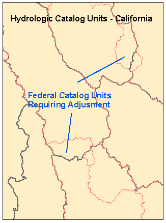
To date, CalWater version 2.2 has been developed and released for use within the State. This version illustrates some of the problems in meeting requirements for WBD.
- Adjustment is required of USGS hydrologic catalog units to match boundaries identified by other agencies.
- CalWater contains boundaries defined by administrative boundaries or by law.
- Watershed areas are not consistent in size.
- Adjustments are needed for large water bodies and coastal areas using under water topographic features.
- Database structure requires adjustment to match WBD requirements and line attributes developed to identify source for boundaries.
- CalWater delineations need review to extract and name appropriate watersheds and sub-watersheds for WBD.
- Some areas such as the Central Valley lack sufficient current elevation information or are substantially modified from natural surface flow patterns that identifying watersheds or sub-watersheds are difficult or impractical.
Review and Integration of HUC Database into CalWater
One problem in the current CalWater is that existing USGS catalog units cross some major breaks in watershed boundaries. This will require modification to catalog units which was not possible until the adoption of the standards. These modifications will require review at the National level to ensure that changes are noted for the existing historic record for catalog units.
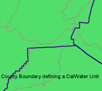
Evaluation and Treatment of Administrative and Legal Boundaries
These boundaries are useful for reference within the State
for both administrative and regulatory purposes. One initial goal in the
development of CalWater was to be able to identify these boundaries and their
relationship to other watershed boundaries in use for the same area. These
boundaries are useful for the separate Regional Water Quality Control Boards operating
under the State Water Resources Control Board as well as other agencies. Their
use in the National database is limited. These boundaries should be retained as
a separate database for the administrative and legal record. In some cases,
there is not any better data to define a watershed or sub-watershed boundary.
IWMC will need to review these boundaries for exclusion or treatment for WBD.
Figure 3 illustrates an example of existing administrative or legal boundaries
carried in CalWater.
Identification of Watersheds and Sub-Watersheds
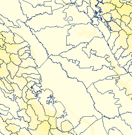
The size of delineations are not consistent for CalWater. This is particularly noticeable for the Central Valley and the southern deserts of California. The U.S. Bureau of Land Management has land management responsibilities for much of the southern deserts. They are actively involved in the CalWater process and will provide the leadership in refining the watershed boundaries for this portion of the State. Identifying watersheds and sub-watersheds in the Central Valley and some other interior valleys provide will be more difficult. These valleys have been substantially modified by agricultural and urban development. There are major water transfers both into and out of the Central Valley. Much of the Central Valley is flat to nearly level in terrain. Natural surface water flow has been greatly modified by land leveling, dikes, and canals including the California Aqueduct. In addition to these structures, portions of the Central Valley are known to have substantial subsidence since the date of topographic mapping for the area. Digital elevation models such as the 30 meter or revised 10 meter DEM data in NED will not reflect the subsidence that has taken place in these areas. Also, depending on the date of photo revision, NHD generated from the 1:24,000 scale topographic sheets may not reflect current changes in stream and drainage system configuration.
Portions of the Central Valley as well as other areas may not have data at sufficient resolution to define watersheds or sub-watersheds. The Federal guidelines recognize that this may be the case for some areas. Some watershed boundaries within the Central Valley may be developed based on CalWater subunits. However, these will require significant modification to reflect hydrologic conditions. Some boundaries follow administrative units. Some are legally recognized. Some reflect common usage. This will require time on the part of CalWater participants to identify what modifications to the boundaries can be adopted and the treatment of boundaries that will not be carried up into the National database but retained as a separate database.
Figure 4 shows a portion of the Central Valley with existing CalWater
Delineations.
CalWater Data Maintenance and Update
Once WBD has been verified for a State, it is expected that these boundaries
will be fairly stable. However, it is anticipated that in California, some
areas such as portions of the Central Valley will not have sufficient
information for further subdivision. Hopefully, this level will be sufficient
for the Federal agencies involved in CalWater to meet requirements for
watershed level planning and management. Involvement of these agencies with the
IWMC provide opportunities for refinement and adjustment of the State database
as more information becomes available.
Summary
- Existing catalog units need to be adjusted with USGS where they do not match appropriate hydrologic delineations.
- Frontal areas along the coast and open water bodies such as lakes need to be evaluated with under water channel and shore line topography to further define watershed boundaries.
- Boundaries based on administrative or legal boundaries need to be eliminated unless justified by common acceptance and usage as the best boundary for that area.
- Existing delineations need to be evaluated against requirements for watersheds and sub-watersheds and coded following the National guidelines.
- Large catalog units that have not so far been delineated into watersheds and sub-watersheds must be delineated.
- Catalog units or watersheds that can not be further divided because existing data is not sufficient must be documented.
- Documentation on the sources for the boundaries must be developed and associated with the line attribute table for WBD.
The guidelines provide an excellent starting point for identifying and explaining requirements for incorporating boundaries from local government and organizations into CalWater by the IWMC. Some of these boundaries may warrent inclusion or adjustment to boundaries that would be carried into the National database. They may provide a basis for splitting out watersheds and sub-watersheds for areas such as the Central Valley. Other boundaries will represent commonly accepted boundaries for administrative, legal, or other purposes that are useful in a separate database at the regional or local level. Treatment of these boundaries should be consistent with the procedures followed for WBD.
Other framework data faces similar issues. NHD and NED are both databases that are expected to include sources at resolutions better than 1:24,000 scale. Identifying requirements for acceptance and incorporation of higher resolution data are major issues for these associated databases.
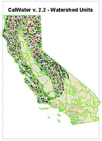
Figure 5 shows the CalWater.
References
Interagency Watershed Mapping Committee (IWMC), California Watershed Map (CalWater) Metadata, 2000. http://www.ca.nrcs.usda.gov/wps/calhum.html.
Natural Resource Conservation Service (NRCS), USDA, Federal Standards For Delineation of Hydrologic Unit Boundaries , June 12, 2001. http://www.ftw.nrcs.usda.gov/huc_data.html.
U.S. Government, Federal Register, Unified Federal Policy for a Watershed Approach to Federal Land and Resource Management, Federal Register, Volume 65, Number 202, October 18, 2000. http://www.cleanwater.gov/ufp/
David T. Hansen
GIS Specialist / Soil Scientist
MPGIS
U.S. Bureau of Reclamation
Mid Pacific Region
2800 Cottage Way
Sacramento, CA. USA 95825-1898
Phone: (916) 978-5268
FAX: (916) 978-5290
Email: dhansen@mp.usbr.gov