The City of Indianapolis/Marion County GIS Division has gone through a series of changes over the past year. In today’s environment, change is inevitable in any organization. Managing a GIS for a large municipal government involves transformations on many different levels, including software architecture, data, hardware, and organizational changes. The purpose of this paper is to relate lessons learned at the City of Indianapolis/Marion County in transitioning from a decentralized group to a centralized GIS Team. Included will be a discussion of transitioning from a desktop supported GIS platform (ArcView) to a Web based (ArcIMS) solution for internal GIS users.
Adapt or die is an often used adage to describe evolution. This also holds true for any Geographic Information System (GIS). Throughout the life cycle of a GIS program, change is inevitable. Being able to adjust or adapt to that change and prevent that change from causing a slowdown or impedance to the strategic direction of the GIS program is the key to its long-term success. In order to provide benefit to the overall organization, the new GIS organization must be more flexible, business-oriented and capable of fast reactions to changing conditions.
This paper will attempt to define the key elements in coping with change through the lifecycle of a GIS program, from initiation and initial data conversion, through the growth cycle to a mature system. Some of the main concepts to address are the importance of planning, documentation, and development of firm policies and procedures. Developing long-term goals and working towards achieving these goals are keys to succeeding with GIS development. In addition, having an operational plan that is flexible will assist the GIS program in coping with changes as they occur.
Many areas of change affect the municipal GIS program. This paper will focus on two areas of changes
On January 1, 2000, Mayor Bart Peterson took office in the City of Indianapolis. This may seem insignificant as elections occur every 4 years in Indianapolis and often a change of administration occurs. However, Mayor Peterson happens to be a Democrat, the first from his party elected to this office after 32 years of Republican control. Obviously, the political situation in Indianapolis changed radically overnight. It would be an understatement to say that the GIS Division (program) was not fully prepared for the change.
Not only did the entire Mayor’s office change hands, but every Department Director and a good majority of management throughout the City also changed over within the first three months of the year. The GIS Executive Steering Committee, which oversees the direction of the GIS program, underwent an 80% turnover at this time. Additionally, the GIS staff that had been working for various City departments came together into one division under the County’s Information Services Agency (ISA). These changes had an immediate effect on the GIS program. Priorities of GIS applications and initiatives were altered to align with the new political agenda. However, one thing remained constant, that being the overall direction that the GIS program was going.
The City of Indianapolis - Marion County GIS project is in what could be termed the mature stage of a GIS. With the inception of the Indianapolis Mapping and Geographic Infrastructure System (IMAGIS) back in 1985, GIS in Indianapolis has been around since the early days of Automated Mapping and Facilities Management (AM/FM). As with most GIS programs, the initial phases involved development of a basemap and landbase data layers. Through the growth stages, more and more layers of information were included and employed within the GIS. As the system grew it began to be used by various technical staff within numerous City departments (namely in the areas of Public Works, Engineering, and Land Management). By the time the project was 10 years old, a sizeable investment had been made into the development of the GIS database. Unfortunately, the benefits of the GIS were not being realized by the current organization.
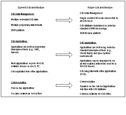
Taking the project from a service delivery mapping shop, where a few GIS professionals created data and maps for every department and agency within the enterprise, to a development, support and maintenance function, was a significant step. The decision was made by the City Administration that in order to reap the benefits of the data that it should be put into the hands of people who use this information on a daily basis. The idea developed of providing GIS to the desktops of any City or County employee who could use this shared information to improve the efficiency of their day to day work effort. This naturally included developing custom applications and tools for users to perform their own GIS functions. Within three years of beginning to put ArcView on the desktops of employees throughout the City and County, over 400 users had been established.
In 1996, the initial idea was to have GIS on the desktop of over 1000 City and County employees by the year 2000. Currently, there are 515 licensed users of ArcView within the City of Indianapolis - Marion County. One of the biggest issues with trying to maintain this number of users is the unanticipated cost of supporting this many desktop licenses of ArcView. Any changes that occur with version upgrades and new applications also bring about issues with keeping a solid inventory and training the individual users on the new programs. The other consideration is software license maintenance costs. For many, the per user costs began to outweigh the benefits received. This is true for those who may not use the software on a regular (daily) basis and may not need the functionality provided by a desktop solution such as ArcView. The thought now is that an internet solution such as ArcIMS can provide these users with a viewing tool to satisfy their GIS needs.
The decision to alter the mode in which GIS is provided to users is especially interesting when making a decision on whether to upgrade any users to the new ArcGIS software. The question then becomes where to draw the line on which users truly need a desktop solution and which can be satisfied with a less robust Intranet or Internet application. Ultimately, this becomes a budgetary consideration for the enterprise. It would be nice to think that software licensing and maintenance costs would not be a limiting factor in providing GIS services. The unfortunate fact is that often times this is the most important decision that a GIS manager has to make.
Throughout the history of the City of Indianapolis - Marion County GIS project, a number of decisions needed to be made on transitioning software, platforms, and application development language (see Table 1).
System Type |
Old Version |
New Version |
Transition Date |
| GIS Software/Vendor | SYNERCOM | ArcINFO (Esri) | 1992 |
| GIS Platform | UNIX | NT | 1995-1996 |
| Editing Software | ArcInfo 7.2 | ArcInfo 8.0.2 | 2000-2001 |
| Data (Viewing) Format | Shape Files | ArcSDE | 2002-2003* |
| Data Maintenance Software | ArcStorm | ArcSDE | 2000-2001 |
| Desktop Software | ArcView | ArcGIS | 2002* |
| Internet Software | MOIMS | ARCIMS | 2001 |
| Application Development Language | AML Avenue | VB C++ other | 1999-2002* |
| Other | Relational | Object Modeling | ?* |
Organizational changes will be unique to each organization. However, regardless of what changes occur within an organization, whether physical or political, transitions in software are inevitable. Planning for these changes, version upgrades, platform changes, database upgrades, and altogether new software packages can make or break a project. Eventually, every GIS project will have to manage a change in software as it grows/matures to meet the needs of its customers. Software and technology are constantly changing and improving. It is difficult, if not impossible, to maintain a system on any given platform or software version for a long time. If software does not evolve, software companies stop making money, the product stops being supported, and projects are stuck with a non-functioning system. Therefore, it is important to plan for changing technology and use it to your advantage as a GIS organization.
Probably the biggest decision made in a project is selection of software to accommodate growth. For Indianapolis, the decision to provide GIS enterprise-wide at the desktop level was made in 1996. ArcView was the logical choice of software and, although it was a significant cost to purchase the original 200 licenses, the benefits of providing this information directly to users outweighed these costs.
The question then becomes an issue of when to make changes in software versions. The City of Indianapolis - Marion County GIS has dealt with this issue and has had to make some critical decisions in a number of areas. At times, it is important to anticipate the future of the business and plan for these changes (i.e. moving to an NT platform for ArcINFO). Many times, software transitions do not turn out as planned. For instance, SYNERCOM went out of business after the software was in full deployment and ArcSDE has yet to be fully implemented as planned. However, decisions related to software transitions should fit in with the overall strategic direction of the organization’s business plan and GIS project.
As the user base began to expand, supporting 500+ users on ArcView (a desktop solution) became a burden for making any upgrades or changes, not to mention the enormous cost of licensing and maintenance. The decision that needs to be made is how to best serve the various GIS users with tools and information they need to do their jobs and stay within budget on cost of GIS software license maintenance and support. Another consideration that needs to be made is the cost of migrating and re-writing the numerous applications that were developed in Avenue for ArcView in migrating users to the new ArcGIS package. Costs also include having to re-train users on the new software. Each of these decisions should address the needs of the users and the benefits received in making the transition. Faster access to data, better data editing tools, better mapping capabilities, and more robust analysis tools are all potential benefits for upgrading GIS software. These benefits have to outweigh the costs for the transition to be effective.
Strategic planning is essential when trying to maximize return on sophisticated technology like an enterprise GIS. As a GIS program continues to evolve, it is critical that foresight and planning are given to the future direction to provide the foundation for the use of geospatial data in supporting an organization’s business plan. The GIS infrastructure of hardware and software will be relied upon to support a continually increasing number of GIS users as a program continues to mature.
Given the current funding and available resources, the GIS program will be challenged to sustain the same high level of service over the next three years. As the GIS program continues to grow and expand, the funding appropriated for the program is flat. Based on existing budgetary and resource constraints, decisions will have to be made on how to continue to provide the GIS services at a high level without increasing costs.
It may sound ironic, but the past success experienced by the GIS program will lead to even greater challenges moving forward. There are over 150 data layers now available and the GIS user community numbers over 500. The average user has become much more educated and demanding than they were when the original GIS Strategic Plan was written in 1998. The challenge of maintaining and supporting the existing GIS infrastructure and user community will consume a greater percentage of the existing fixed GIS resource budget than in the past. This will be achieved at the expense of developing new applications and data in the same aggressive timeframe as in the past. The City of Indianapolis/Marion County GIS program is in an enviable position, having managed to build a solid infrastructure of data and applications, and having built one of the largest GIS user communities in the Country. The program is well positioned to attain an ever-increasing return on its GIS investment by leveraging the GIS infrastructure already in place. Moving forward, the continued evolution of the GIS into an enterprise tool impacting City/County employees and citizens alike, can be assured with continued funding and support from Executive leadership. The objective for the GIS Strategic Plan is to help provide the blueprint and direction for how this environment will be obtained and yet include the flexibility to incorporate new priorities over time.
The initial reaction to change is fear. Transitions of any variety whether political, organizational, or technical in nature are inevitable within any GIS program. One lesson learned from an organizational standpoint is to have the ability to remain flexible through organizational and political transition. Another important lesson learned over the years in the City of Indianapolis - Marion County GIS has been to avoid letting the software drive the project direction. It is important to know what the software capabilities are, but it is also easy to get trapped into the “new cool stuff” game. However, it is also important to not get too far behind in the technology (software), that catching up becomes overly painful. Anticipating and coping with changes can be the difference between the success and failure of any project. Planning for change and developing a sound strategic plan can turn these transitions into positives rather than causing severe damage to the project.