Why Profile Communities?
For several years the South Carolina Department of Commerce has been providing a myriad of information to prospective and existing industries through its web site. This information includes available industrial buildings, available industrial sites and parks, existing industries, and capital investment figures. The underlying goal of this activity is provide clients with the information to make decisions regarding business relocation or expansion in the state of South Carolina.
Increasingly, the Department recognized the need to provide detailed information about the state's communities. Quality of life issues such as education, health care, and recreational opportunities have become important factors for many corporations in their search for the ideal location. This project was born as a direct result of the need to harness the community information in the Department's vast GIS database and deploy it to the Internet in the most efficient manner possible.
Data Concerns: Determining a "Community" and its Scope
The first step in this project was to determine what constituted a community. The Department's past attempts at profiling communities focused on the state's larger cities and county seats. However, for this application the Geographic Names Information System developed by the USGS, was used to identify inhabited geographic places. As a result, 1,438 communities were identified for inclusion in this application. This method helped create a database of communities that included not only the largest cities in the state, but also the smaller, rural towns which are often sited for industrial development.
What are the advantages to this approach? First, it created data points uniformly distributed across the entire state, so that even if a prospective industry is looking to locate in a unincorporated community, they will certainly find a point of reference in our database that is within close proximity to almost any location. Secondly, from a political standpoint, this approach satisfies even the smallest town in the state by including them in the database.
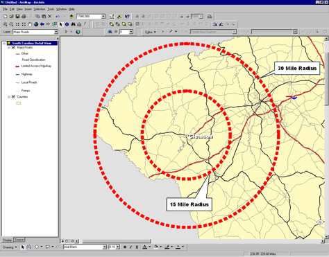
The scope of a community, or its area of influence, often falls beyond traditional political boundaries. This is largely due to the influence of the automobile and its effect on commuting patterns, and suburban and exurban development. For these reasons, 15, 30 and in some cases 60 mile radii were used to gather data from each community and surrounding environs. For example, population and labor data were collected from 15 and 30 mile radii from the center point of each community. Institutions such as colleges and universities were collected from larger 30 and 60 mile radii because of their increased influence and importance on a regional level.
|
|
| Figure 1. A Community's Area of Influence. |
Data Collection: The Foundation of the Application
As all GIS professionals know, a successful application is highly dependent on the quality and accuracy of its data. This project was no different. The Department of Commerce employed a wide variety of data sources in order to create complete profiles of each community. Population and labor data was extracted from the 1998 Claritas Retail Solution Series. All distances to ports, interstates, and major cities were computed using an extensive road network developed in-house. Climatic data was provided by the South Carolina Department of Natural Resources while information regarding accommodations and meeting places was received from the South Carolina Department of Parks, Recreation, and Tourism.
The remaining data was part of a 1998 CDBG grant that established a quality of life feature inventory in South Carolina. Department staff collected thousands of points representing features such as hospitals, religious establishments, attractions and other features via GPS and phone book research. This data in large part became the foundation of this application.
The collection of raw data for this project was a time consuming, multi-agency process that took nearly a year to complete. The next section of this paper will detail the process used to extract the raw data from the coverages obtained from outside agencies or those created in-house as a result of the CDBG grant.
Data Extraction and Deployment
The process for extracting the data for this application was by no means a cutting-edge one. A series of AMLs were written that systematically parsed through each community, collected the associated features within the specified radius, and appended the data to an INFO file that was eventually exported to a Microsoft Access database. Once in Access the data was then summarized by the ID number of each community in preparation for queries in Cold Fusion.
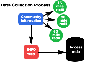 |
| Figure 2. Data collection process . |
This process, although slow at times, proved to be the best means to collect the data. Because of the large number of communities and the variety of data to be included in each profile , it was determined early on in the development stage of this project that an 'on-the-fly' web-based application using ArcIMS would not be the best option. Although the majority of information comprising the profiles was GIS-based, the presentation of that information was most efficiently done in a tabular manner. For this reason, ColdFusion became the logical application for deploying this data to the web and creating a searchable interface that allows users to find communities based on specific criteria.
Cold Fusion was chosen as the deployment tool for this project for a number of other reasons:
- The Department of Commerce has several existing ColdFusion applications running on its Web site.
- ColdFusion is easy to learn and easily adaptable for staff members with prior HTML experience.
- ColdFusion allows for integration with other components of the profiles including graphics, static maps, and text files.
- ColdFusion's server-side technology allows for efficient processing of user requests.
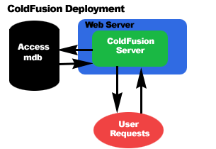 |
| Figure 3. ColdFusion processes all requests server side and returns results directly back to the user. |
The interface of the application consists of two forms; the first a simple search consisting of a drop-down menu where users can search for communities by county and a text box where users can enter the name of a community. The second form presents a more advanced search where users can enter criteria based on labor and population ranges and distances to interstates, ports, and airports.
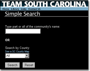 |
| Figure 4a. The simple search interface |
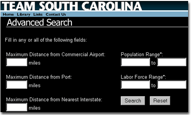 |
| Figure 4b. The advanced search interface |
Once criteria is submitted by the user, ColdFusion parses the Access database and returns communities fitting those parameters. The user can then choose to view the specific profile of the community they are interested in. The data contained in each of the profiles includes the following:
- Demographics: Population for 1990, 1998, and 2003 for 15 and 30 mile radii, household income, and educational attainment.
- Economic: Labor force and employment by group occupation.
- Climate: Average temperature, precipitation, and early/late freeze dates.
- Transportation: Distances to airports, interstates, port access and railroad access.
- Public Services: Fire protection, the number public and private schools, school districts, colleges and universities, doctors, dentists, hospitals and museums.
- Utilities: Electric and natural gas providers.
- Major Manufacturing Employers
- Miscellaneous: Hotel and meeting accommodations, places of worship, a description of the community's region, distances to major cities in the southeast, pictures from the community's county, and a location map.
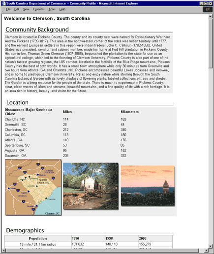 |
| Figure 4c. The community profile of Clemson, SC |
Because of the amount of data used in each profile, ColdFusion was a logical choice for this application. Aside from the ease in developing a well designed user interface, ColdFusion allowed us to establish one template that would serve as the final depository for each community's profile (see figure 4c). This template provides the necessary functionality to include other information such as a location map, 'chamber of commerce' photos, and a small introductory paragraph describing the community.
Lessons Learned and Future Possibilities
Overall, the use of ArcInfo and ColdFusion in this project has proven very successful in creating a comprehensive tool for the analysis, query, and retrieval of community information in the state of South Carolina. Although the technology employed is simplistic, its results have been well received by the clients of this state looking to compare and contrast South Carolina's diverse communities.
The next step in the development of this project is to provide community and labor profiles based on drive time polygons for all communities. This is being done in direct response to requests from clients who view this information as extremely important in identifying optimum areas for industry location. By extracting this information from drive time areas of 15, 30, 45, and 60 minutes, a community profile that is more in tune with real world conditions can be produced. For example, we can identify all of the parts suppliers for a major automobile factory within a 60 minute drive of the factory. This form of information is much more accurate than the radii analysis used in the current application, because it takes into consideration such factors as topography, natural barriers, and the type of infrastructure in place. It is also much more accurate in identifying the potential labor markets that may exist within the commuting areas.
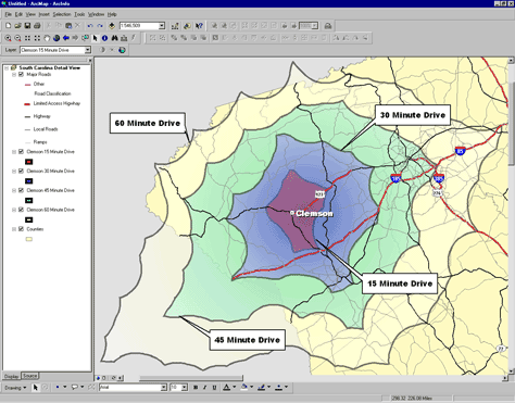 |
| Figure 5. Drive time polygons around Clemson, SC show 15, 30, 45 and 60 minute drives from the center of town. |
Currently, the creation of the over 5,700 drive time polygons for the state has been completed. This was done using the 2000 TIGER road file for South Carolina and adjacent counties in Georgia and North Carolina. Using the Census classification system for roads, a speed limit was assigned to each road segment and then a time impedance was calculated based on the length of each segment. The resulting road networks for 15, 30, 45 and 60 minute drives from each community were then buffered to create polygon outlines as seen in Figure 5. These polygons will now be used to extract point and Census data for each community when this information becomes available in the upcoming months.
Upon completion, the drive time-based labor profiles will be a comprehensive addition to the community profiles. Together the two will provide users with a complete synopsis of all South Carolina communities and assist prospective industries in their decision to locate operations in South Carolina.