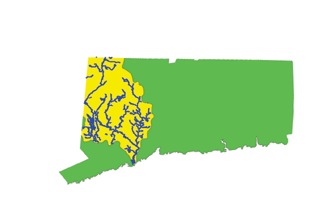
Figure 1. Study Area for the State of Connecticut - Housatonic River Basin.
The U.S. Environmental Protection Agency (EPA) Office of Water is developing a water quality standards database (WQSDB) that will enable EPA, States, Tribes, and the public to view designated uses and criteria for the surface waters of the United States on the Internet. An important feature of the database is its ability to map the WQSDB information in a consistent way. This can be achieved by conflating the State in-house mapping products to the National Hydrography Datase (NHD). This paper examines the feasibility of using EPA's Reach Indexing Tool (RIT) to facilitate this conflation process based on data from three States. It highlights the steps and tools used in the development of the water quality standards mapping component of the WQSDB as part of the EPA's Watershed Assessment and Tracking Environmental Results System (WATERS).
Introduction
The U.S. Environmental Protection Agency (EPA) is developing a National Water Quality Standards Database (WQSDB) to improve public access to information about the Nation's surface waters. The first phase of this on-line database will consist of compiling the "designated uses," stating the function(s) each waterbody is intended to support, such as fishing, swimming, drinking water source, or some other use. Ultimately, the WQSDB will include additional site-specific standards data, including water quality criteria. When completed, the database will allow access to maps and data for all of the approximately two million surface waters across the Nation.
Water quality standards (WQS) comprise a three-part system for protecting the Nation's surface waters: designated uses, water quality criteria, and antidegradation policies.
The Water Quality Standards Database allows the user to view the designated uses of waterbodies in a structured way. The designated use information is currently available for 16 States in table form, with a mapping component available for 11 of those States. EPA intends to expand the database to include designated uses and water quality criteria for each waterbody in all 50 States, authorized Tribes, and all U.S. Territories. In addition, an Internet Repository of State and Tribal water quality standards is also available on EPA's web site. This new web site can be used to obtain the full text of water quality standards that are in effect under the Clean Water Act for each State and for each Tribe authorized to develop standards.
EPA is integrating its databases into one common geographic platform. The integration project, known as WATERS (Watershed Assessment, Tracking & Environmental Results), unites water quality information previously available on individual State agency home pages and at several EPA Web sites. State and Federal water quality managers, as well as interested citizens, can use WATERS to quickly identify the status of individual waterbodies of interest to them. WATERS also can be used to generate summary reports on all waters in a given State. The WQSDB is a major component of the WATERS system. Currently, WATERS can display program information including impaired waters from the 303(d) list and the designated uses from the WQSDB. EPA will update WATERS as new information becomes available. For a detailed description and future releases about WATERS see Dabolt et al.(2001) in these proceedings.
The visualization of the WATERS information is provided via EPA's standard mapping application, EnviroMapper. The EnviroMapper for the EPA Office of Water is a Web-based geographic information system (GIS) application that dynamically displays information about bodies of water in the U.S. This interactive tool allows users to create customized maps portraying the Nation's surface waters along with a collection of environmental data. The application can be used to view environmental information from the National level down to community level (within one mile), and provides the ability to pan, zoom, label, and print maps. EnviroMapper also provides links to the table reports in the WQSDB after identifying a specific waterbody of interest. The EnviroMapper application relies on spatial data from the National Hydrography Dataset (NHD) and allows the display of designated use information and other EPA Water Program Information that are geo-referenced (linked) to the NHD. This process, also known as reach indexing, uses EPA's Reach Indexing Tool (RIT) (Spoerri et al., 2000). The reach indexing effort was the foundation of the development of the NHD-based WQSDB mapping component (Ilieve et al., 2000). The reach indexing technique known as conflation (transfer, convert) of State in-house coverages from 1:24K and 1:100K scale to the 1:100K NHD format, and the quality assurance/quality control (QAQC) process that utilizes the Web-based GIS are the focus of the following discussion.
Development of NHD-based State Designated Use Coverages
The water quality standards mapping effort currently supports the first phase of the WQSDB as defined above, i.e., the spatial representation of the designated uses based on NHD hydrography. The other parts of the water quality standards, namely water quality criteria and anti-degradation policies, will be addressed as they become available in the WQSDB.
Many States have already converted their designated uses from hardcopy maps to a GIS format generally at 1:100K or 1:24K scale. The ultimate goal of EPA is to include such products that provide a spatial representation of States' designated uses into the National WQSDB. The resolution and format of the digital WQSDB data layers vary among States because these products are not created with consistent hydrography across all States. The 1:100K resolution National Hydrography Dataset provides a consistent hydrography layer to which data such as the State designated uses can be attached (USGS and EPA, 2000). Our discussion of the reach indexing process addresses the conflation to the 1:100K NHD data format of designated use data coverages for States using both 1:24K and 1:100K scales.
In the small Northeastern States (such as Connecticut), the designated uses data layer was created at a 1:24K scale in order to provide a high resolution representation of the State's waters. In order to create a nationally consistent mapping product based on the NHD, this 1:24K data layer must be conflated to the 1:100K NHD format. The RIT facilitates this conflation to NHD. There is some concern, however, that data might be lost in the conflation from a high resolution State coverage (1:24K) to the lower resolution NHD hydrography (1:100K). To address this concern, an investigation into the methods and success rate of such a conflation was performed for Connecticut.
In the Pacific Northwest (PNW) States (such as Washington), the designated use coverages have been created based on the 1:100K PNW hydrography used in the region. In a majority of States (such as North Carolina), the designated use coverages were developed based on an in-house 1:100K scale hydrography layer. In both cases, the RIT will be used to conflate the 1:100K scale State coverages to the NHD format. The goal is to determine the success of the conflation between such data formats with the understanding that additional investigation might be needed to address the large variety of coverages used in different States.
While most of the currently available State coverages are at 1:100K scale, more and more States are expressing interest in working at 1:24K scale. In an effort to address this growing trend, we will start our discussion with the 1:24K scale, and then move to 1:100K scale, addressing first the Pacific Northwest (PNW) region. Finally, we will compare the RIT manual and automatic methods of conflating 1:100K scale data to the 1:100K NHD.
Conflating 1:24K WQS (Designated Use) Mapping to 1:100K NHD
Demonstration reach indexing conflation of Connecticut's 1:24K designated uses to the 1:100K NHD format. The goal of this task was to explore techniques and success rates for conflation of 1:24K designated use coverages to the 1:100K NHD format. This reach indexing conflation was performed on the Housatonic River Basin, USGS 8-digit Cataloging Unit (CU) 01100005 (Figure 1). The State of Connecticut provided a 1:24K resolution ArcView coverage that contained spatial representations (linear and polygon) of the State's designated uses. This coverage was overlaid on the NHD and the coverage's spatial features were conflated to the NHD using the RIT.
Figure 1. Study Area for the State of Connecticut - Housatonic River Basin.
Reach Indexing Method: Linear events are created to replicate the linear coverage features, waterbody shapefiles are created to replicate polygonal coverage features, and point events are created to represent features (linear or polygonal) of the coverage that do not exist in the NHD. The linear event feature was defined with the from and to position of each stream segment along an NHD route reach. The point event feature was defined with a point position along the NHD route reach. The waterbody (polygon) shapefile does not use from/to or point measures, but shapefiles to store the geographic properties. In such cases, the reach code came from the waterbody region reach feature in NHD rather than the NHD route reach (Spoerri, et al, 2000). The proportion of point events created can be used to calculate the conflation success rate for the designated uses from the original State coverage to the NHD. The linear and waterbody NHD events represent successful conflations, while the point events represent conflation failures.
Connecticut has produced two digital coverages (line and polygon) representing all designated use waters for the entire State at a resolution of 1:24K. These coverages were delineated based on the State's waterbody classification system. With the designated use coverages overlaid on the NHD for CU 01100005, the RIT was used to select NHD reaches and waterbodies that correspond to the line or polygon features contained in the designated use coverage. These selected features were then re-created in an NHD event theme as either linear or waterbody features. Segments of the designated use coverages without a corresponding NHD feature were represented by a point created in an NHD point event theme. With all features of the designated use coverage conflated to NHD linear, waterbody (polygon), or point features, it was possible to develop success and failure statistics for the conflation of features.
Results: The overall success rate for the conflation of features in CU 01100005 is 96.24%, with the remaining 3.76% displayed as points along the NHD. Table 1 shows the total count of events (point, line, and polygon) that were indexed in NHD based on the Connecticut coverages. These counts and percentages are valid for the Connecticut CU 01100005. All points represent features in the Connecticut coverage that were missing in NHD.
| Feature type | Event Count | Percent of Total |
|---|---|---|
| Point | 29 | 3.76 |
| Polygon | 90 | 11.67 |
| Line | 652 | 84.57 |
| Total: | 771 | 100 |
Table 1. Distribution of feature classes for the Connecticut CU 01100005.
Figure 2 shows a selected region of the CU 01100005 that was indexed to NHD with the Connecticut designated use coverage in the background and the NHD indexed events overlaid. The selected area reveals that three stream reaches (highlighted in yellow) in the Connecticut designated use coverage were not represented within the NHD and therefore displayed as point events on NHD.
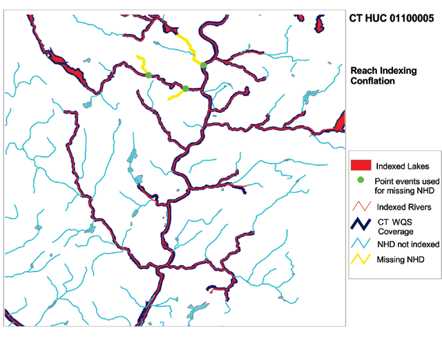
Figure2. 1:24K Designated Use Conflation of Connecticut CU 01100005 area.
Findings: The demonstration conflation of Connecticut designated uses to the NHD for CU 01100005 indicates that the features in the 1:24K coverage can be conflated to 1:100K NHD with a high rate of success (over 96%). All features that were not conflated to the NHD are represented with point events. These point events provide only a "proxy" representation of the actual features, and can be troublesome in situations where several features are located along one reach that is not represented in the 1:100K NHD. This occurred only three times in the demonstration indexing of CU 01100005 and therefore does not affect the results. The high success rate suggests that the conflation of features from the 1:24K coverage to the 1:100K NHD is feasible and can be completed without losing significant amounts of information. Point events can be used as markers for the location of missing features, but they do not provide any information about the extent or characteristics of the missing features. This conclusion is valid for the State of Connecticut and might not apply to the remaining Northeastern States, which need to be examined on an individual basis.
Conflating 1:100K WQS (Designated Use) Mapping to 1:100K NHD
Pacific Northwest States. The reach indexing study for these States is addressed separately because these States historically use PNW hydrography.
Demonstration reach indexing conflation of Washington's 1:100K PNW designated uses to the 1:100K NHD. The goal of this task was to explore techniques and success rates for the conflation of 1:100K PNW designated use coverages to the 1:100K NHD. The State of Washington provided a set of 1:100K PNW coverages of their designated uses, which were overlaid with the NHD for CU 17020015 and 17020016 (Figure 3). The RIT was used to create NHD events that reflect the information provided in the designated use coverages as closely as possible.
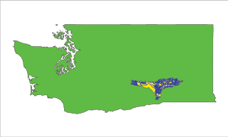
Figure 3. Study Area for the State of Washington, CUs 17020015 and 17020016.
Reach Indexing Method: The Washington 1:100K designated use coverages contain waters listed by their designated use classifications. These coverages were directly overlaid on the NHD, and the RIT was used to select and index any NHD reach that corresponded to the features of the designated use coverage. Linear or polygon features in the designated use coverage were conflated to linear and waterbody features of the NHD, and any coverage feature that did not have a corresponding feature in NHD was indexed as a point event. The relative number of linear, waterbody (polygon), and point events (as described in the 1:24K conflation method) were used to develop the statistics for this process.
Results: All of the features of the Washington PNW designated use coverage were conflated to NHD events. The success rate for the conflation of features to the NHD for both CUs was 100%. Figure 4 shows the Washington PNW shapefile overlaid with NHD-based indexed events for a selected area of CU 17020016. The high level of similarity between the Washington PNW coverage and the NHD can be easily seen.
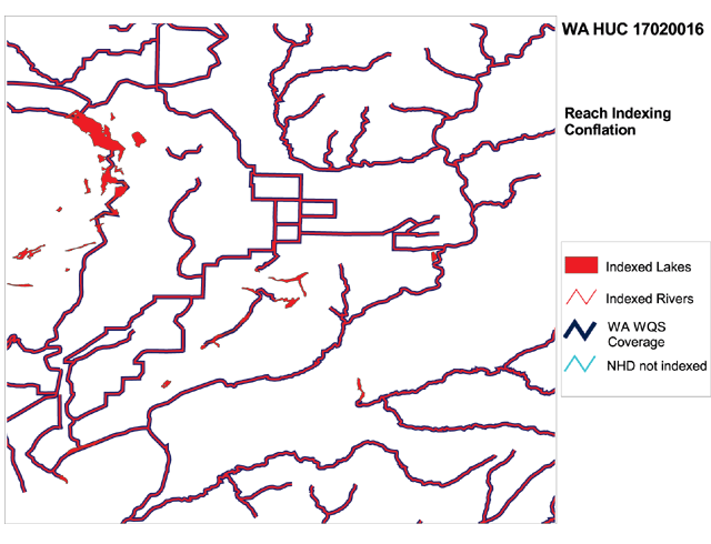
Figure 4. 1:100K PNW Designated Use Conflation of Washington CU 17020016 area.
Findings: The 100% success rate for the conflation of features from the Washington PNW coverage shows that the designated use information can be indexed to the NHD without any loss of data.
100K States. Currently, the majority of U.S. States use their own in-house 1:100K hydrography layers, although many states are moving to NHD.
Demonstration reach indexing conflation of North Carolina 1:100K designated uses to the 1:100K NHD. The goal of this task was to explore techniques and success rates for the conflation of 1:100K designated use coverages to the 1:100K NHD, using the Upper Neuse River Basin, CU 03020201. (Figure 5). The RIT was used to attach hydrography features to the NHD. The RIT can be used to visually select river reaches to reach index to the NHD based on text descriptions, or based on coverages overlaid with the NHD and automatically conflated followed by a user quality assurance/quality control (QAQC) process. This QAQC process allows the user to review the automatically conflated features and adjust the conflation manually. In this task, designated use data for CU 03020201 were conflated both manually and automatically with RIT, and the results were compared to determine the feasibility and accuracy of manual and automatic conflation.
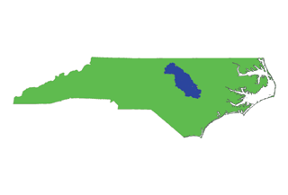
Figure 5. Study Area for the State of North Carolina - Upper Neuse River Basin.
Reach Indexing Method: The RIT can be used in two ways to replicate the features of a coverage in the form of NHD events. Linear and waterbody features of the NHD can be manually selected and reach indexed, or they can be conflated automatically with the "Convert to NHD Events" utility of the RIT. Manual reach indexing requires the user to visually duplicate the spatial features of the coverage in the form of NHD events.
The RIT's "Convert to NHD Events" feature automates the reach indexing process. The utility compares the input coverage (in this case the North Carolina designated use coverage) to the NHD and creates event tables in the NHD to represent the features of the coverage. The automated process creates both linear and waterbody events, but does not create point events to represent missing features of the NHD. The conflated events must be visually compared to the coverage in order to determine the number of coverage features that were not conflated to NHD events. The RIT's "QA/QC Converted NHD Events" feature guides the user through the process of comparing the State coverage to the newly created NHD events, allowing the user to correct mistakes made by the automated conflation process. Point events can be created to represent the features that failed to conflate between the two data types.
Results: Manual Conflation. The manually created event tables reveal a high level of correspondence between the 1:100K designated use coverage created by North Carolina and the features of the NHD. A total of 2,226 features were created manually for CU 03020201. Of those 2,226 features, 14 were point events. Using point events as a measure of missing features of the North Carolina coverage, there was a 0.63% failure (99.37% success) rate in the conflation from the coverage to the NHD events (Figure 6). The manual reach indexing included joining the USGS Geographic Name Information System (GNIS) with the North Carolina designated uses, locating the waters on a topographic map and reach indexing the waters with the RIT. This detailed analysis was done to demonstrate the high level of success (over 99%) of conflating North Carolina's 1:100K in-house designated use coverage to the 1:100K NHD.
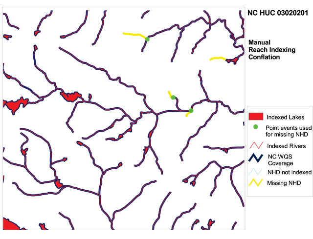
Figure 6. 1:100K In-House Manual Designated Use Conflation of North Carolina CU 03020201 area.
Results: Automatic Conflation and QAQC. The automated process for conflating coverage features to NHD events produced both waterbody and linear NHD events. These events differ from those created through the manual process (Figure 7). Some features of the coverage were not conflated, or were conflated incompletely to the NHD. It proves difficult to provide a general quantitative estimate of the rate of success, because it depends on the geographic location of the CU, i.e., coastal, mountain, area with numerous lakes/ponds, etc.
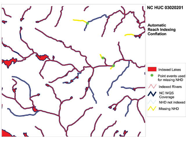
Figure 7. 1:100K In-House Automatic Designated Use Conflation of North Carolina CU 03020201 area.
Findings: The amount of time required to create NHD events manually can be reduced through the use of automated "Convert to NHD Events" feature based on the comparison of the two methods for the North Carolina CU 03020201. The automatic process provides a good first pass, but the RIT's "QAQC Converted Events" feature should be used to correct any misrepresented features in the NHD events. The results demonstrate that the "Convert to NHD Events" feature of the RIT (automatic conflation) and the "QAQC Converted Events" can save up to 40% of the time required to do the reach indexing manually without sacrificing data quality.
State Web-Based Review Sites
Once the WQSDB attributes and the designated use mapping components are developed, they must be reviewed and certified by the States to ensure accuracy in both interpretation of the document and waterbody locations. Only after this process is completed can the State designated use coverages be made available to the public via the EPA Office of Water EnviroMapper application.
The entire State review process can be completed via the Internet on separate Web review sites available to the States and EPA personnel. Currently, there are two sites for the review of water quality standards: one dedicated for the WQSDB attribute information (Figure 8), and one for the designated use spatial (reach indexed to NHD) information (Figure 9) .
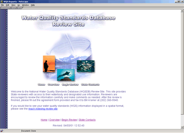
Figure 8. Water Quality Standards Attribute Information Web Review Site.
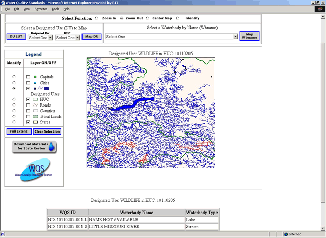
Figure 9. Water Quality Standards Spatial (Reach Indexing) Web Review Site.
WQS Attribute Review Site. This site provides State reviewers with access to their waterbody and designated use information. Review guidelines are provided to explain the contents of the reports and possible errors. Two major options are available:
WQS Reach Indexing Review Site. This site was developed to facilitate the State review process of each State's designated use reach indexing effort. It was implemented using a Web-based GIS approach. Two major options are available here as well:
Currently, the reach indexing review site only displays the designated use portion of the WQSDB. The next phase of the review site will incorporate the chemical, biological, and physical criteria that support the designated uses, which are being populated into the WQSDB. In the future, users will be able to view the linkage between the designated uses and the associated criteria. For more details about this site and its functionality, see Miller and Ilieve (2000).
These review Web sites allow States to download and view their WQS attribute data and designated use coverages in a more timely manner. They provide States easy access to their water quality standards information and enable States to provide corrections and feedback. Using a Web-based approach, data can be easily maintained and updated without having to repeatedly send out CD-ROM data packages. Draft WQSDB attribute and designated use reach indexing information on the Web review sites allow States to review and approve (certify) the data before they are made available to the public. Up-to-date information on the progress of the WQSDB and its mapping component where users can check the status of any State in this National WQS effort (Figure 10).
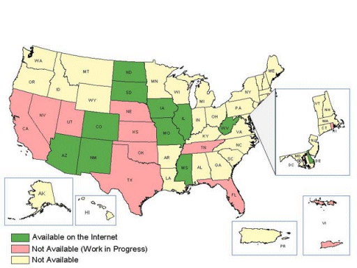
Figure 10. Status of the National Water Quality Standards Effort.
Conclusions
The National WQSDB will provide information on water quality standards to environmental professionals, the regulated community, watershed associations, and interested citizens.
The presented analysis of applying the EPA's Reach Indexing Tool in the development of consistent NHD-based mapping products is very timely considering that States are addressing EPA's request for better visualization of the surface waters under the various programs mandated by the Clean Water Act. The RIT appears to be an efficient and effective tool for conflating State designated use coverages from several formats as 1:24K, 1:100K PNW, and 1:100K in-house to the 1:100K NHD. However, RIT's automatic "Convert to NHD Events" feature should be used in concert with the "QA/QC Converted NHD Events" to ensure sufficient accuracy.
As part of the WATERS information system, the WQSDB and its mapping component (displayed via the EPA Office of Water EnviroMapper application) will serve as an important tool for monitoring State progress in attaining water quality standards, providing communities the information they need to protect local waterways, and alerting the public to potential health risks.
Acknowledgments
The work described in this paper was funded by the U.S. Environmental Protection Agency under Contract 68-C-01-001 with Research Triangle Institute (RTI). RTI gratefully acknowledges this support. RTI would like to extend a special acknowledgment to Thomas Dewald, Thomas Dabolt, and Michael Plastino from the EPA Office of Water, who were instrumental in this National georeferencing (reach indexing/addressing) effort.
Disclaimer: Although the research described has been funded wholly or in part by the U.S. Environmental Protection Agency Contract 68-C-01-001 to Research Triangle Institute, it has not been subject to the Agency's review and therefore does not necessarily reflect the views of the Agency, and no official endorsement should be inferred. Mention of trade names or commercial products does not constitute endorsement or recommendation for use.
References
Dabolt, O.T., et. al. 2001 (in press). Water Assessment and Tracking Environmental Results System (WATERS). In: Esri User Conference 2001, San Diego, CA, July 9 -13.
Spoerri, C., A.M. Miller, and T. Dabolt. 2000. The Reach Indexing Tool for the National Hydrography Dataset: Functionality and Impacts on State Water Programs. In: Esri User Conference 2000, San Diego, CA, June 26 -30.
Ilieve P.I., J.M. McCarthy, A.M. Miller, K.L. Sparks, W.S. Cooter, and E.C. Barrett, and Jeffrey Bryan, 2000. Displaying Water Quality Standards Information Using Web-based GIS: A Foundation for Water Quality Management. In: WEF Watershed 2000, Vancouver, BC, July 8-12.
Miller A.M., and P.I. Ilieve. 2000. Water Quality Standards GIS Review Implementation: Moving from a Static Website to a Web-based GIS. In: Esri User Conference 2000, San Diego, CA, June 26 -30.
U.S. Geological Survey (USGS) and U.S. Environmental Protection Agency (USEPA). February 2000. The National Hydrography Dataset: Concepts and Content.
U.S. EPA (Environmental Protection Agency). April 2001. National Water Quality Standards Database Fact Sheet. EPA-823-F-01-009. Office of Water.
Anne Marie Miller
Research GIS Specialist, GIS Lab
Research Triangle Institute
3040 Cornwallis Road
RTP, NC 27709
919-485-5691
ammiller@rti.org
William Kramer
Lead Environmental Specialist
U.S. Environmental Protection Agency
1200 Pennsylvania Ave., N.W.; Mail Code 4305
Washington, DC 20460
202-260-5824
Kramer.Bill@epamail.epa.gov
Jeffrey Bryan
Associate Chief
U.S. Environmental Protection Agency
1200 Pennsylvania Ave., N.W.; Mail Code 4305
Washington, DC 20460
202-260-4934
Bryan.Jeffrey@epamail.epa.gov