This paper shows how GIS is being used in all aspects of an Environmental Impact Statement. A prime focus was to minimize environmental impacts for 14 miles of new roadway in Randolph County, NC. Potential impacts to residences, historic properties, streams and wetlands needed to be balanced with engineering constraints. The GIS enabled the Detailed Study corridors to be selected faster than by traditional methods. These were then converted to Microstation for use by roadway design engineers. Agency coordination is facilitated with interactive ArcView sessions. GIS maps are used in newsletters, workshops and a web page hosted by NCDOT.
Earth Tech, Inc., is using GIS in preparation of an Environmental Impact Statement for the North Carolina Department of Transportation (NCDOT). The project is TIP R-2536, US 64 Improvements. The NCDOT proposes to improve the existing US 64 corridor in the area of the City of Asheboro in Randolph County. As part of this action, the NCDOT also proposes to improve the access to the North Carolina Zoological Park.
Steps taken as part of the environmental study process include:
We are currently awaiting comments from NCDOT on the submittal of the DEIS.
The project is needed for a number of reasons. The US 64 corridor has existing and projected traffic volumes that greatly exceed the capacity of the road. Visitors to the North Carolina Zoological Park (NC Zoo), one of the state's largest tourist attractions, must travel a circuitous two-lane non-access controlled route to reach the NC Zoo from the interstate system, resulting in confusion and delay for them. Congestion at the entrance to the NC Zoo makes it difficult for the local residents to access their homes. The accident rate along existing US 64 is nearly double the state average for this type of road. The Intrastate System was created to provide high-speed, safe, regional travel service. The existing and projected traffic and land use conditions along existing US 64 through Asheboro diminish this segment's ability to function as an intrastate corridor.
Data has been collected from various sources to build the ARC/INFO GIS database. These include NCDOT, Randolph County, the National Wetlands Inventory and American Digital Cartography, Inc. The data was verified with field checks and compared to aerial mapping provided by NCDOT.
The objective of the corridor selection is to find reasonable and feasible alternatives for more detailed study. Initially, 96 potential centerline alternatives were identified within the refined study area. These were quickly narrowed down to 29 for further analysis. The goal is to minimize impacts to features of the natural and human environment. These include wetlands, streams, threatened and endangered species, floodplains, residences, businesses and historic property, illustrated below in Figure 1. The alternatives also have to take into consideration engineering constraints, such as the maximum skew angle with the crossroad at an interchange, and avoiding pronounced changes in topography where practical.
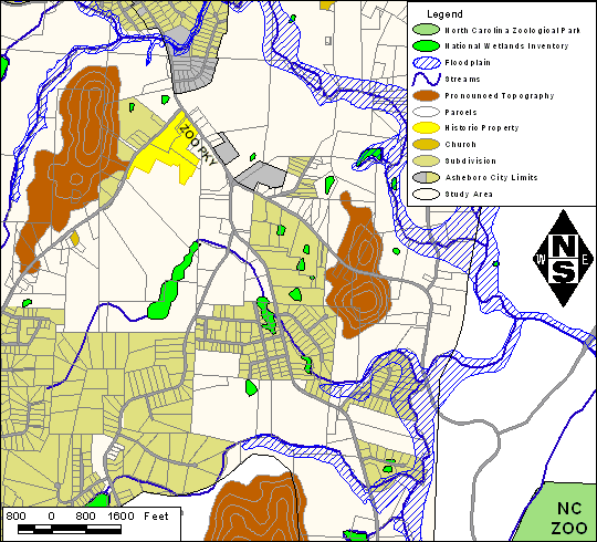
Figure 1. Primary Constraints
The 29 centerlines were added to the database and buffers were generated to produce 1000-ft wide corridors. An AML program was written to intersect the corridors with each of the specified features, depending on the feature type. Numbers, lengths and areas were tabulated and sorted in order to find the corridors with the least overall impact on the environment.
From the 29 alternatives, nine were suggested for more detailed study. They comprised essentially an inner and outer corridor, with some crossovers that resulted in the nine alternatives. These alternatives were put into an ArcView project, along with the features used to determine them. An interactive demonstration was presented by Earth Tech at NCDOT to participating North Carolina State Regulatory Agencies, such as the Federal Highway Administration (FHWA), the Fish and Wildlife Service (FWS), the United States Army Corps of Engineers (USACE) and the Department of Environment and Natural Resources (DENR). Based on input from these agencies, one more crossover was added, to provide more flexibility. This generated a total of 33 alternatives, which were reanalyzed using the same AML as before. The group was again narrowed down to nine alternatives, with one of them being different from the earlier group. The agencies agreed with the selection of these alternatives, shown below in Figure 2.
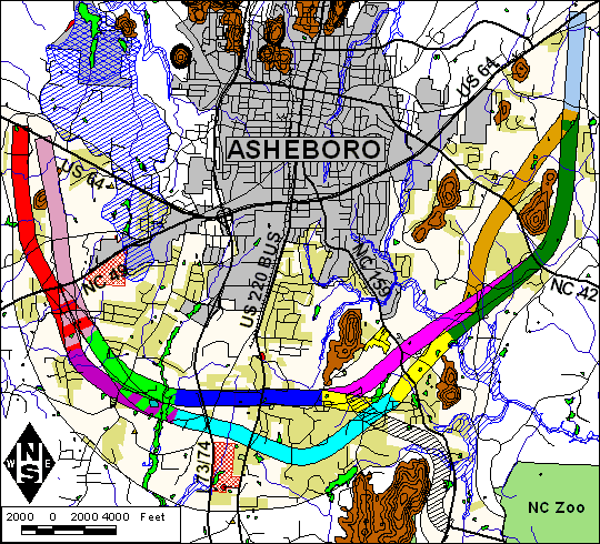
Figure 2. Detailed Study Alternatives
Using the selected alternatives, aerial photography was flown by NCDOT, and provided to the Earth Tech roadway engineers for preliminary design. The nine 1000-foot corridor outlines were converted to Microstation *.dgn format (using the ARC/INFO command arcigds), and referenced to the base mapping generated from the aerial photography.
The GIS project was developed in North Carolina State Plane Coordinates, with the North American Datum (NAD) of 1983 in meters, because the initial base GIS mapping provided by NCDOT was in that system. The preliminary design was done in feet, so the corridors had to be projected into feet before being converted to Microstation. The data from Randolph County was in NAD 27, feet, so this also had to be converted to work with the NCDOT GIS data. An AML was written to facilitate reprojection of data, as periodic data updates were received from Randolph County, and data was transferred between Microstation and ARC/INFO on a regular basis.
Detailed studies are conducted to select not only the least environmentally damaging practicable alternative, but also the best alignment possible for the roadway within the alternative corridor. Field surveys included identifying potential protected species effects, relocations, potential hazardous material sites, potential underground storage tank sites, and historic architecture properties. Technical Memoranda were produced for the following subjects: natural resources, historic and archaeological resources, hydraulics studies, noise analysis, air quality analysis and socio-economic studies. The GIS was used in compiling the results of all of these technical studies, and for calculating natural resources impacts.
The aerial photography from NCDOT was used to generate 17 paneled overlapping field maps showing the corridor outlines. Earth Tech biologists mapped the natural communities, streams and wetlands on these maps in the field. Representatives from USACE and FWS verified the identification process, and the wetlands and stream transition points were then field delineated using GPS. The output as *.dxf files was input into the GIS and the Microstation design files, for use in the preliminary roadway design. Community boundaries were screen digitized into the database. Natural community acreages and stream lengths were calculated and included in the Natural Resources Technical Memorandum.

Figure 3. Field Map used by Biologists
Public Involvement is a large part of a project having approximately 14 miles of roadway on new location. There have been two Citizens Informational Workshops to date. The mailing list was generated initially by using the GIS to intersect the parcel boundaries with the refined study area, shown below in Figure 4. This generated a list of about 800 names, all of whom were sent newsletters. At both workshops were large display maps showing features relevant to the public, an automated slide show, and members of the study team to talk to citizens about the project. About 400 people attended each workshop. A hotline is also operational, where people can call a 1-800 number, and receive information about the project, or add their name to the mailing list. It currently has about 1300 names in it, and is updated periodically when we receive updates of ownership information from Randolph County. Small group meetings have also been held. One of these was at a monthly lunch meeting of area realtors. We took a Power Point presentation, and showed them the project with an interactive ArcView session.
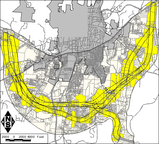
Figure 4. Parcels Selected For Mailing List
A web page has also been created by Earth Tech, and is hosted by NCDOT: http://www.dot.state.nc.us/projects/asheboro/ This shows project related information, and maps of the project. They were designed to be easily accessible to the general public, and therefore the maps are static images that do not require high end computer power.
Figure 5. NCDOT Webpage Header
As soon as the Draft Environmental Impact Statement has been reviewed by NCDOT any necessary revisions will be made. A combined corridor and design public hearing will be held next, to show the public all information about the project, including the preliminary design. A Preferred Alternative will be selected following this hearing, and the Final Environmental Impact Statement prepared. After the official Record of Decision, a second Design Public Hearing will likely be held to show the preferred alternative and any revisions in the proposed design, based on NCDOT's avoidance and minimization efforts. Construction can then begin, assuming funding is available.
By using the GIS for this project, the alternatives comparison could be done faster than by the traditional method of using aerial mapping. This enabled the identification of the best potential corridor for detailed study without extensive field efforts. After the corridors were identified, the GIS was used for field work preparation and results compilation. The public is well informed about the project through newsletters, public meetings and a web site, all utilizing maps generated from the GIS.
I would like to thank Jill Gurak, P.E., Ron Hairr (both of Earth Tech) and Gail Grimes, P.E. (NCDOT), who have been very supportive of the GIS involvement in this project.