Potomac
Corridor Historic Resources IMS:
Connecting
Past and Present
Jacquelyn M. Strager, Research Coordinator
Natural Resource Analysis Center
West Virginia University
Dan Bonenberger, Associate Director
Institute for the History of
Technology and Industrial Archaeology
West Virginia University
ABSTRACT
A recent collaboration between the Natural Resource Analysis Center
and the Institute for the History of Technology and Industrial Archaeology
at West Virginia University has produced an IMS application that presents
information on historic cultural resources located in central Appalachia.
Developed using Esri’s Map Objects technology, this interactive, web-based
mapping project allows users to search and display descriptive and locational
information for hundreds of historic structures along three famous transportation
routes that crossed the Appalachians via the Potomac River valley. The
Potomac Corridor Historic Resources IMS website makes a valuable contribution
to heritage tourism and cultural resource management.
INTRODUCTION AND BACKGROUND
Project Participants
The Natural Resource Analysis Center (NRAC) and the Institute for the
History of Technology and Industrial Archaeology (IHTIA) of West Virginia
University have combined to produce the online Potomac
Corridor GIS. The NRAC is a multi-disciplinary GIS facility in
the College of Agriculture, Forestry and Consumer Sciences at West Virginia
University, with research activities concentrated in environmental planning,
natural resource economics, wildlife management, forest ecology, and reclamation.
The IHTIA, a unit of the Eberly College of Arts and Sciences at West Virginia
University, has a mission to “document, analyze and preserve our nation’s
industrial heritage while providing unique educational opportunities.”
This pilot project has been financed in by West Virginia University
in partnership with the National Park Service (NPS) Historic American Engineering
Record program with technical support from the NPS branch of Mapping and
Information Technology and the Library of Congress Prints and Photographs
Division.
Transportation Routes and the Potomac Corridor
In the early 19th century, the Appalachian Mountains formed a seemingly
insurmountable barrier to east-west trade within the rapidly expanding
United States. Historic transportation routes forged across the Appalachians
of central Pennsylvania, Maryland, and West Virginia offer prime examples
of important early American structures and buildings, including bridges,
tunnels, power plants, mills, and more. This work focuses on three
of these routes: the National Road, Chesapeake and Ohio Canal, and the
Baltimore and Ohio Railroad.
Cataloging Historic Resources
Significant architectural, engineering, and industrial works along these
three routes and throughout the United States have been catalogued and
documented by the Historic American
Buildings Survey (HABS) and Historical
American Engineering Record (HAER), both administered by the National
Park Service. Together, information collected by the HABS/HAER programs
is archived by the Prints and Photographs Division of the Library of Congress.
The Library of Congress makes primary source material including digital
images (site drawings, photographs, written records) for individual HABS/HAER
sites available through the American
Memory historical collections website. Some of the most important
historical resources of the United States are recognized on the National
Register of Historic Places (NRHP).
With the use of Internet mapping technology, the Potomac Corridor GIS
serves to link digital maps of site locations to the wealth of information
available in the HABS/HAER and NRHP programs. The Potomac Corridor
GIS is one example of a small number of GIS-enabled websites interfacing
geographic locations with historic resources. On a much larger scale,
the Alexandria Digital Library
project hosted by the University of California, Santa Barbara has developed
an interactive gazetteer combining data from the US Geological Survey’s
Geographic Names Information Service and the National Imagery and Mapping
Agency’s GeoName Server.
By linking the records of the past with the technology of the present,
we provide a valuable and timely resource to educators, researchers, and
those interested in cultural heritage tourism.
WEB-BASED MAPPING FOR THE POTOMAC CORRIDOR GIS
Website Development
The Potomac Corridor GIS web mapping interface was developed using Esri’s
Map Objects and Map Objects IMS technology. At the time of website
development, ArcIMS had not yet been released. Future upgrades may
include eventual system migration to ArcIMS. Advantages of the use
of Map Objects included ease of site customization, and the ability to
limit the functionality of the site to basic GIS functions combined with
easy-to-use search capabilities. We specifically wanted to avoid
the look and feel of an ‘out of the box’ mapping website template.
Site programming and customization was performed using Microsoft’s Visual
Basic 6.0, and the resulting web site is served using Microsoft’s Internet
Information Server (IIS) software.
Website Functionality
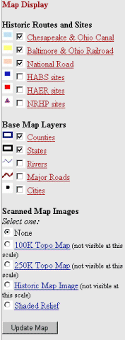
The Potomac Corridor GIS web site has been designed for the non-technical
GIS user, with simple map functions and directed search capabilities (Figure
1). Map functions include zoom in, zoom out, pan, and identify.
Users may toggle the visibility of vector and image-based map layers.
The visibility of several of the more detailed image layers is scale-dependent,
ensuring that image backdrops are displayed appropriately as site users
zoom to different map extents.
Figure 1. Potomac Corridor GIS web site's initial map display.
Map layers are listed on the left, map controls, search interface, and
instructions appear below the map image.
Additional features of the Potomac Corridor GIS include a brief metadata
record for each map layer, including a description of the data source and
helpful links to related information. The webpage also provides a
link to a printer-ready version of the user’s current map window.
Data Included
The main spatial data layers referenced on the Potomac Corridor GIS
are shapefiles of historic points (found within about 1 mile of each of
the three historic transportation routes) from the HABS/HAER, NRHP, and
IHTIA databases. Other ancillary datasets are shown for reference,
including state and county outlines, major roads, and rivers. The
user has a choice of background images, including a shaded relief map and
topographic maps of various scales and levels of detail. For certain
areas with high concentrations of historic features, 1:24,000 topographic
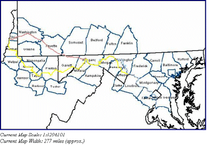
maps are available. A scanned historical map of western Maryland
is currently provided on the site as a background image (Figure 2), and
additional historical map backgrounds will be added during the second phase
of the project in order to provide a richer context for the point data.
Figure 2. Historical map background image (dated 1873) for
western Maryland, from the Potomac Corridor GIS map window. Transportation
corridors and historic point features are drawn on top of the image background.
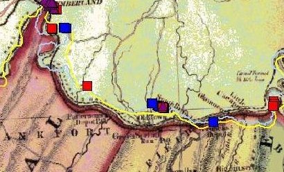
Table 1. Data layers and sources incorporated in the Potomac
Corridor GIS.
| Data Layer |
Data Source |
| C+O Canal |
USGS DLG data, 1:100,000 scale, NPS towpath mapping |
| B+O Railroad |
USGS DLG data, 1:100,000 scale |
| National Road |
USGS DLG data, 1:100,000 scale |
| HABS/HAER point locations |
HABS/HAER database coordinates, additional georeferencing
by IHTIA |
| NRHP point locations |
NRHP database coordinates |
| Counties |
US Census Bureau TIGER data |
| States |
US Census Bureau TIGER data |
| Rivers |
US EPA River Reach version 1 |
| Major roads |
US National Highway Planning Network data |
| Cities |
US Census Bureau |
| Topographic maps |
1:24,000, 1:100,000 and 1:250,000 scale USGS DRG data |
| Historic map images |
Various sources |
| Shaded relief map image |
USGS DEM data with hillshade |
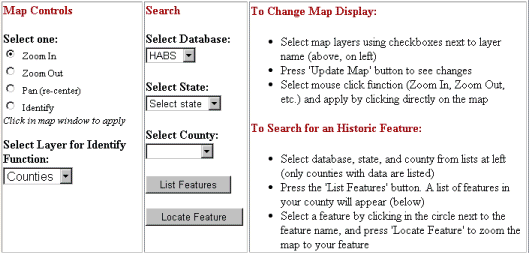
The simple search interface incorporated into the site’s design performs
queries against the various historic point shapefiles by database, state,
and county. Query results are shown directly on the resulting webpage.
Query results are also hyperlinked (in the case of HABS/HAER records) to
related information on the external American Memory webpage at the Library
of Congress.
Figure 3. Example of query results (user has queried historical
points database for HABS sites in Marion County, WV.)
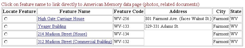
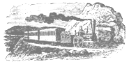
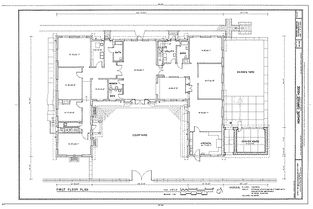
Figure 4. Example of measured drawing of High Gate Carriage
House, Fairmont WV from American Memory web page hosted by the Library
of Congress. The Potomac Corridor GIS provides hyperlinks to individual
American Memory webpages for various historical sites.
Website Users
Electronic cultural heritage resources such as the Potomac Corridor
GIS website attract a varied audience, including those with an interest
in research, education, and cultural tourism. Project coordinator
Dan Bonenberger exhibited the pilot website at the Electronic
Cultural Atlas Initiative's January 2001 conference in Hong Kong.
The project website has since been presented at the annual conference of
the Society for Industrial
Archeology in May 2001.
Future Work
We expect that the Potomac Corridor GIS will continue to evolve and
expand with the constantly changing field of web-based mapping technology.
We also plan to expand the depth and breadth of information available through
this interface in a number of ways. Additional scanned images of
historical maps will be added to the website, beginning with the National
Road. An updated version of the HABS/HAER database will be reviewed
and plans will be made for integrating all HABS/HAER records for the central
Appalachian states. We are prepared to expand the scope of the site
beyond the current historic corridors to include resources found along
scenic byways, rail-trails and other historic features throughout the region.
ACKNOWLEDGMENTS
This work was funded by West Virginia University in cooperation with
the National Park Service's HABS/HAER and Mapping and Information Technology
branches. We thank Dean M. Duane Nellis of the Eberly College of
Arts and Sciences at West Virginia University and E. Blaine Cliver, Chief
of HABS/HAER for their support of this project. Deirdre McCarthy
with the NPS Mapping and Information Technology branch provided additional
technical assistance. Brian Renzella contributed valuable efforts in compiling
geographic coordinates and other information for inclusion in the GIS datasets
used for this project. Bryan Tolka and Dr. Jerry Fletcher of the
Natural Resource Analysis Center also provided support and assistance.
AUTHOR INFORMATION
Jacquelyn M. Strager
Natural Resource Analysis Center
West Virginia University
PO Box 6108
Morgantown, WV 26506-6108
USA
Phone: (304) 293-4832 ext.4455
Fax: (304) 293-3752 |
|
Dan Bonenberger
Institute for the History of Technology and Industrial
Archaeology
West Virginia University
PO Box 6305
Morgantown, WV 26506-6305
USA
Phone: (304) 293-3589
Fax: (304) 293-2449 |

|
|
|
Link to project website:
http://www.nrac.wvu.edu/scripts/Esrimap.dll?name=ihtia&cmd=Map