Figure 1. Opening the View With Themes Added
Real time information from roadside sensors may be used to update GIS databases dynamically. Distributed pattern recognition (local or network-wide) can be used to transform these updates into messages to automated messaging system boards. The same information can be used to serve dynamic maps on the Internet rather than static ones. The integration of sensor-generated data into the updating of the network database may be accomplished with scripts written in Avenue. Surrounding issues, such as data communication, current sensor technology etc. must be incorporated into the design.
Effective use of the transportation networks is affected by real time network conditions. Severe weather conditions such as snow or flood, incidences such as accidents, periodic maintenance and peak hour congestion can completely or partially shut off certain segments of road networks, causing serious routing problems. While the technology is available to automatically reroute a driver around an incident by using in�built navigation systems, the turn-by-turn directions obtained from the Internet by specifying the origin and destination do not take into account real-time road conditions. Real-time traffic information however is available to consumers in other forms that are equally desirable. For example TravVia Web Traffic offers to consumers real-time traffic information displayed as icons on regional maps. Clicking the icons reveals real-time text report of incidents, weather related conditions and events that may affect traffic flow (1). The combined effort of Tele Atlas (Etak) and Metro Networks provides traffic reporting service in Wireless Application Protocol (WAP) and other standard formats. The service enables subscribers to receive real-time traffic information for their personal routes through variety of wireless and wire line devices including pagers, cell phones, in-car navigation devices and wireless-capable laptop computers (2). States and local governments such as Maryland (3) and Montgomery County in Maryland (4) often provide real-time construction, weather, incident, special event and congestion related traffic information as color-coded road maps with legends describing the various nature of incidents or as text reports. Navigation Technologies produce Traffic-enabled NAVTECH map data that allows motorist to instruct a navigation system to calculate alternate routes based on real time reports of accidents, delays, congestion, construction, slowdowns, and travel speeds that impact traffic flow and travel times.
This paper discusses how ArcView Network Analyst can be utilized to modify the existing process of obtaining turn-by-turn directions from the Internet by using the real-time information collected from the road sensors. The existing process of obtaining a turn-by-turn direction is described, followed by a description of how real-time road condition is currently being collected, stored and disseminated. Finally how Avenue is used to incorporate the collected real-time information into the process is described.
ArcView Network Analyst can be used to model the real world conditions and hence provide the shortest or quickest route as long as the network, calling points (stops) and the cost of traversing the individual links are identified. Two parameters normally define the cost of traversing a link, the length of the link and the time taken to traverse the link (5). The cost function for a particular link in the segment may be defined as its impedance. Various parameters such as speed limits, pavement conditions can contribute to the link�s impedance.
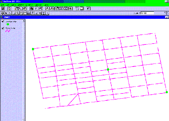
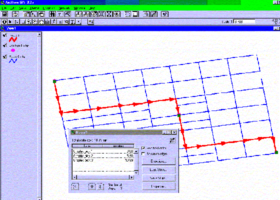
A typical process of obtaining a turn-by-turn direction(the shortest or quickest route) involves adding the road network and the stops themes to a view as shown on the Figure 1 below. The theme paper3.shp is the network while the theme ucstops is the calling points stops.
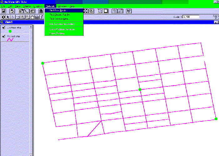
After adding the required themes, the next step is to define the problem to be solved. Selecting �network� from the menu bar and then �find the best route� from the drop down opens the problem definition dialog (see Figure 2). From the dialog the stops may be loaded if the theme was previously added to the view, otherwise the stops may be selected from view. The selected points (stops) may be saved as a theme for later use. Additionally, the dialog has buttons to customize the cost of traversing the links, buttons to define whether the problem is solved for a round trip or one way only and a button to obtain directions(5).
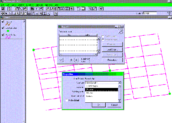
By clicking on properties button from the problem definition dialog the cost of traversing the road segments can be selected from the dropdown list opened. The properties dialog with drivetime selected as the cost is shown in Figure 3 below. The existing turn-by-turn directions are based on link lengths or travel time. The cost of traversing the links often selected from the properties dialog are hours and minutes for travel time and for segment lengths miles and feet.
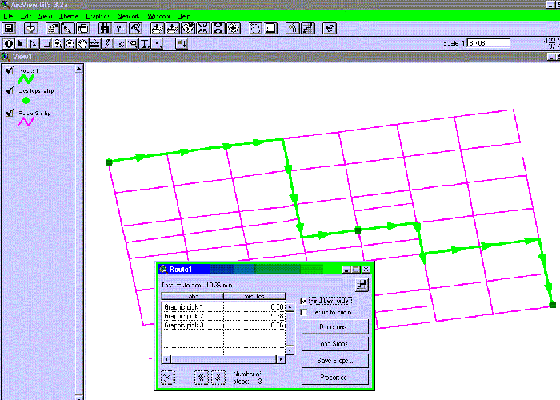
The existing system makes use of the known lengths of the road networks and the speed limits associated with each link to determine the travel distance and travel time. When an origin and destination is specified, the program tries every possible combination of links that connects the locations and selects the combination that return the shortest distance or the shortest travel time. The direction obtained when the problem is solved is based on either of the two � the shortest distance if the shortest route is required and the shortest travel time if the quickest route is required. A theme attribute table exists as part of the network theme and contains record of lengths and speed limits. ArcView Network Analyst uses the database to solve the problem of determining the shortest or quickest route through sets of locations. The lengths and speed limits are constant parameters therefore the results obtained from Network Analyst after solving for the shortest or the quickest route will always remain constant unless the changes in the road network condition and the subsequent changes in travel speed can be incorporated into the theme attribute table. For example Figure 4 below shows the directions generated by using the database based on the existing road condition. The cost of traversing the links used is drivetime in minutes.
Transportation Personnel in charge of operation decisions require timely and accurate dissemination of road conditions. An effective turn-by-turn direction generating system based on timely and accurate road conditions should therefore take into account changes in traffic flow due to the following:
The conditions listed above have the potential of completely or partially shutting off parts of the road network and in the process creating routing problems. In addition to taking in account the specifics of the incidents and events, the system should consider the location of incidents and the time the incident is expected to clear.
A direction generating system that takes into account the conditions listed above has to be dynamic since those conditions change from time to time and from link to link. Since various conditions exists, there is need to establish the threshold for setting the link�s impedance to infinity, which renders a link not to be a part of the list included as part of the shortest or quickest path. Some of the link conditions that could warrant setting the link impedance to infinity are:
The modification requires these components:
The most important field data required is the average travel speed. The information is currently collected by government agencies using traffic speed detectors and in-pavement loop detection traffic counting devices retrofitted to provide speed information. The overall effect of all the incidences, events and the weather conditions is a reduction in the travel speed from the allowable speed limit. The accurate measurement of the travel speed through all the links effectively captures the real-time road conditions of the links.
By transferring the link�s speed data collected by the road side sensors to a collection center and then to a direction generating system and repeating the process at an acceptable interval, generates a real-time turn-by-turn direction.
The application responds to incoming link speed data by updating the existing database field of allowable speed (speed limit) with the transferred data, the current operating speed collected from the road sensors. The program, based on the threshold condition stipulated above determines the combination of links that return the shortest or quickest route and in the process generates direction generation based on the route selected.
The application is implemented as Avenue scripts, which run within the ArcView execution environment. Since the real-time speed data are is stored in another system (an Operation Center), to implement the modification of the existing theme attribute table in the direction generating system a Dynamic Data Exchange (DDE) process is required to enable the transfer. During the DDE conversation, ArcView GIS serves as the client while the system that stores the collected real-time speed data (the Operation Center) serves as the server. The item (the information to be exchanged) is the average speeds of the various links. The preferred link is hot link since the operation center supplies new data to the client every time the data exchanges.
Assume the server�s application is a Visual Basic program named myvb.exe and that the program contains a form with the form�s LinkTopic property set to speed1 and a text box control named Text1. The code below establishes a DDE conversation with myvb (the server).
Once a DDEClient object is created, the link speed information can be transferred as a non-spatial attribute data file and used to update the speed column of the existing database. ArcView does not support automatic link. The client must request the new data from the server each time. The request for transferred of data from the server is repeated at an interval of thirty (30) minutes.
Using ArcView Network Analyst to solve the problem of determining the shortest route based on the updated table yields a more accurate turn-by-turn direction than the existing directions available now through the Internet. Figure 5 below show the direction generated when real-time road conditions are taken into account.
The research reported in this paper was supported by a faculty Research Grant from the National Center for Transportation Management, Research and Development (NTC). NTC is part of the USDOT University Transportation Centers Program. The center was established by Congress under the Intermodal Surface Transportation Efficiency Act of 1991 (ISTEA), and reauthorized in 1998 by Transportation Equity Act for the 21st Century (TEA-21). The NTC is located on the Morgan State University campus in Baltimore Maryland