
Meris Sims, B. S. and Elizabeth Smith, Ph.D.
Rookery Islands support a diversity of colonial nesting waterbird species along the Texas Coast. Colonial waterbirds are a highly valued resource to many people in the United States, but the habit of nesting in large groups makes these birds susceptible to a variety of problems including human disturbance, severe weather events, and competition for nesting habitat. They also face threats of habitat degradation, loss and contamination of their environments, and change in food webs. Commercial and recreational traffic along the Gulf Intracoastal Waterway within the Laguna Madre of Texas create varying levels of disturbance to nesting birds. Both erosion and natural vegetation changes also affect potential use of the islands by colonial waterbirds.
Many natural and dredged material islands are utilized by numerous species of colonial nesting waterbirds. These islands range in size, elevation, and vegetation complexity. Ten Islands within the Padre Island National Seashore located adjacent to Laguna Madre in south Texas are being evaluated in a larger study partially funded by National Park Service, to determine appropriate strategies to both conserve and restore these essential habitats. The use of GIS provides the natural resource manager and waterbird researchers with a multidimensional tool to assess island dynamics over time and target areas that are in need of conservation or restoration measures. Therefore, the purpose of this paper was to 1) develop an appropriate methodology to assess historic changes of island size and vegetation on one natural and one dredged material island; and, 2) provide recommendations that would minimize loss of habitat and enhance nesting habitat potential on these rookery islands.
Padre Island National Seashore is located on the South Texas Gulf coast within one of the longest barrier islands in the world. The park encompasses 133,000 acres that is comprised primarily of gulf beach, dunes, vegetated flats, wetlands, and tidal flats. The eastern boundary of the park includes several natural and dredged material islands within the Laguna Madre, one of the five hypersaline lagoons in the world. The dredged material islands were constructed as the result of excavation and maintenance of the Gulf Intracoastal Waterway. Two methods of disposal were utilized: unconfined where material was placed directly in the Laguna Madre, or confined were dredged material was placed within a constructed block levee system.
Two methods were used to determine areal extent and habitat changes from 1995 to 2000 using ArcView 3.2a. In the first method, images from 1995 digital orthophoto quarter quads (DOQQ) in South Bird and South of South Bird and 7.5 min quads were used for analysis using the Image Analyst extension. In the second method, shape files generated from Trimble GPS Datalogger II on island and vegetation perimeters was used to generate data for 2000.
In the first method, the 1995 images were categorized using the Iterative Self-Organizing Data Analysis technique (ISODATA) in Image Analysis. This technique conducts a categorization of data to create a “Categorized Data Theme”. ISODATA recalculates the statistics of the pixel’s and the similarity to each other and places them into categories based upon the calculated values. It is called “self-organizing” because the groups of data are created with limited input from the user; the number of categories is the only input necessary. This technique uses the maximum number of iterations and a convergence threshold to calculate the parameters for each category. An iteration is defined as how many times that the categorize function recalculates the data, and is set at a default value of twelve but can be changed using Avenue. The default was chosen in this study, and categories were edited and labeled using the Categorization Theme, then converted to a new shapefile, named and saved. Categories for this method were: shrub, herbaceous shrub, bare and intertidal, herbaceous, and algae pond. The new theme categories were then edited to a standardized color scheme. Areal extent (acres and hectares) of each polygon was reviewed viewing the Attribute Table. Class areas were renamed within the table using editing commands, then closing Legend Editor, Stop Editing, and Save Edits.
In the second method, 2000 data from the Trimble unit were downloaded into PathFinder Office, and converted to shapefiles to import into ArcView 3.2a as themes. Categories for this method were: herbaceous shrub, and bare and intertidal. Areas were calculated using the Map Calculator utility, by adding fields (AREA, PERIMETER) in the attribute table.
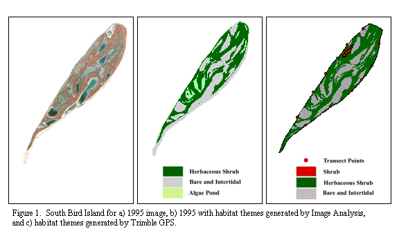
South Bird Island is composed primarily of herbaceous shrub and depressional ponds that can fill with rain and/or high tides. These numerous ponds were delineated by both methods, although the Image Analysis method further delineated ponds that seem to exhibit some algal mat formation. Shrubs mapped in the field in 2000 using Trimble GPS were not detected in the 1995, however, were present in that period. The quality of the DOQ may have decreased the ability of the Image Analysis program to detect this small habitat theme.
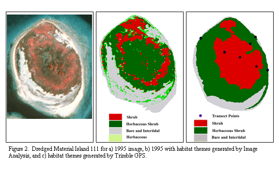
Dredged Material Island 111 had an increased amount of shrub, composed primarily of an impenetrable thicket of prickly pear cactus (Opuntia linderheimeri). More herbaceous shrub was delineated by the Image Analysis method within the cactus ring. In the second method using the Trimble GPS, the cactus prohibited access to the island interior; therefore, the amount of shrub is overestimated. In the 1995 Image Analysis method, herbaceous habitat was delineated in narrow bands along the perimeter and throughout the herbaceous shrub habitat. No effort was undertaken to map this habitat with the second method in the field, although this is entirely possible given sufficient time.
Both methods were used to determine if island and habitat sizes had changed between 1995 and 2000. On South Bird Island, 10.67 ha were delineated for all habitats combined, compared to 9.08 ha in 2000. Herbaceous shrub habitat increased from 5.30 ha in 1995 to 5.60 ha in 2000. Bare and intertidal habitat (including algal pond) decreased from 5.37 ha in 1995 to 4.81 ha in 2000. The overall decrease in size of this island may be attributable to the delineation of island perimeter in both methods. In the 1995 image, intertidal bare habitat was present along the entire perimeter, whereas, this habitat type was field surveyed during a high tide event. The loss of this habitat was most apparent along the eastern shoreline in 2000, but is not correct for current conditions.
The island size delineations for Dredged Material Island 111 were 4.66 ha for 1995 and 4.41 ha in 2000. Combining all vegetated habitats in both years, these areas increased slightly from 3.18 ha in 1995 to 3.19 ha in 2000. Field surveys throughout the island along several transect lines substantiate this increase in vegetation in the northeastern and southwestern quadrants. The species that colonized these areas were composed primarily of early succession grasses and low shrubs. Bare and intertidal habitat decreased from 1995 (1.48 ha) to 2000 (1.32 ha), presumably as a result of increase in vegetation. However, the Image Analysis method did delineate an area in the south quadrant of bare and intertidal that may have been undetectable during high tides in 2000.
Obtaining aerial imagery of sufficient resolution at yearly intervals is often cost prohibitive. Therefore, alternative methods that employ field surveys in conjunction with using GPS dataloggers improves the ability to detect changes in habitat sizes on islands between aerial surveys. The use of Image Analyst on DOQQ images assists in the identification of habitat types that can be groundtruthed with minimum effort, once the user is familiar with vegetation in the field. The comparison of changes from the aerial image with GPS dataloggers in the field is useful, if the user is aware of habitat delineations and comparable field conditions (i.e., tides).
The establishment of long-term monitoring strategies is essential to ensure the productivity of rookery islands for colonial waterbirds within the Padre Island National Seashore. We recommend employing both field surveys and use of GIS to assess spatial changes to island size, configuration, and habitat complexity over various temporal scales. The baseline surveys conducted during this study were useful in determining appropriate habitat classifications for use in the GIS project. Evaluation of historic changes of shoreline perimeters using GIS is useful in prioritizing sites to restore habitat and/or provide erosion control to habitats under threat of degradation or loss. Spatial comparisons of islands not currently used by nesting colonial waterbird species with active rookery islands may clarify enhancement strategies. Continued use of ArcView GIS program and extensions as outlined within this paper will allow natural resource managers a flexible tool to manage monitoring data as well as track future restoration/enhancement projects. The use of Image Analysis provided the best delineation of habitat types, although the use of field GPS dataloggers is essential when current aerial images are not available.