Abstract Four sites on military installations or managed by military agencies illustrate how EQuIS has been implemented as a core component of a more comprehensive environmental program to provide information to the decision-maker. With quick and easy access to discrete sampling information, analytical and conceptual models, and GIS, these systems constitute a valuable resource management tool for both proactive and reactive decision making.
Introduction
The seamless integration of subsurface environmental geology and analytical chemistry data with the latest tools and technology for data management and analysis make site characterization and investigation more efficient than ever before. EarthSoft’s Environmental Quality Information System—EQuIS—has been chosen by many military agencies and organizations for the management of analytical chemistry and geology data. The extensive integration with industry-standard applications for visualization and analysis make EQuIS a popular foundation for what is often an extensive environmental program or plan. The implementation of EQuIS at Robins Air Force Base, on the Central & South Florida project by the Army Corps of Engineers, on South Weymouth Naval Air Station, and Minnesota’s Camp Ripley is investigated.
Robins Air Force Base
Robins Air Force Base, located in Warner Robins, Georgia, is home to the Warner Robins Air Logistics Center as well as more than 60 other units that comprise a critical interest in the United States’ Air Force fighting operations. Robins AFB employs nearly 20,000 civilian, contractor, and military personnel and is the largest industrial complex in Georgia. Covering 8,722 acres, the base contains over 14 million square feet of maintenance, administrative, and storage facilities, and the longest runway in Georgia at 12,000 feet long, with an estimated total replacement value of almost $5 billion. One of three USAF air logistics centers, Warner Robins Air Logistics Center is responsible for the maintenance, repair, and modification of several aircraft worldwide. These aircraft include the F-15 Eagle, C-130 Hercules, C-141 Starlifter, C-5 Galaxy, and all helicopters as well as special operations aircraft and weapons systems.
Environmental responsibility and liability at Robins AFB is handled by the Environmental Management Directorate, which "establishes, implements and manages environmental programs, systems and procedures to ensure compliance with federal, state and local laws and regulations". The Environmental Management Directorate is organized into three branches: the Pollution Prevention Division, the Compliance and Restoration Division, and the Environmental Resources Division.
The Pollution Prevention Division engineers and implements programs to reduce air, water, and land pollution by 1) managing solid and hazardous wastes, 2) environment-friendly practices such as recycling, and 3) promoting the purchase of post-consumer content products in all operations.
The Compliance and Restoration Division serves to protect human health and the environment by ensuring that base operations are in compliance with state and federal regulations. This division also conducts investigation and remediation of contaminated sites and manages the Installation Restoration Program and Resource and Conservation Recovery Act (RCRA) Corrective Action Program which remediates soil, groundwater, and surface water contaminated by past practices.
The Environmental Resources Division is the focal point for all environmental programs; its responsibilities include the administration of finances, personnel, equipment, and supplies for the base. The Environmental Compliance Assessment Management Program (ECAMP) and the Environmental Impact Analysis Process Program (EIAP), as well as the management of the cultural and natural resources program are all handled by the Environmental Resources Division. In 1994, the Environmental Management Directorate received the Department of Defense (DoD) award for Best Overall Environmental Quality Program, and in 1995, 1997, and 1998 the DoD Pollution Prevention Award, Industrial Category.
In the mid 1990s, the Compliance and Restoration Division acquired EQuIS to support their objectives in the management of analytical data from contaminated areas within the base and to help ensure compliance with environmental regulations. The comprehensive EQuIS data structure is being used as a back-end data repository. Currently, 2,730 sampling locations and over 800,000 result records are maintained in EQuIS. Data are now associated with ArcCatalog layers, and within the next year it is intended that the environmental data contained within EQuIS as well as facility features and map layers will be made available via the web through ArcIMS.
The Compliance and Restoration Division of the Environmental Management Directorate at Robins AFB is using EQuIS to provide an interface for project managers to store and retrieve analytical data about groundwater, soil, surface water, and sediment sampling locations throughout the base. The continuing objective is that managers are able to easily access, view, and interpret data to efficiently assess the success of their remediation programs.
Central & SouthERN Florida Project
The Central & Southern Florida Project (C&SF) dates back to 1850 when the United States Congress passed the "Swamp and Overflowed Lands Act". While water problems surely existed in Florida for many centuries prior to 1850, this Act declared ownership of swamp and overflowed lands to the state. Sale of lands to private interests was to fund the work of reclamation. However, due to poor transportation, debt, politics, and the ravages of the Civil War, little was accomplished for the next 30 years.
In 1881, the first contract was signed to drain overflowed lands and over the next several decades reclamation progressed as previously inundated lands were used for farming and settlement; by 1921, an estimated 2,000 people inhabited the lake region. However, hurricanes in 1926 and 1928 swept through the region killing nearly 3,000 people and destroying vast areas of development. These disasters pressured the government to action and saw the beginning of involvement in water control by the U.S. Army Corps of Engineers.
In 1947, following one of the worst droughts in Florida history, 100 inches of rain fell in southern Florida, filling lakes and canals. Not long thereafter, two hurricanes and more rainfall devastated the area, resulting in 90% of southeastern Florida being underwater and an estimated $59,000,000 damage. Following the prompting of several local agencies, the Corps of Engineers’ Jacksonville District conducted hearings thoughout the state to determine the best course of action. The consensus was that the problems were too widespread and complex to be handled by state and/or local agencies alone. In December of 1947, the Corps presented a report to the U.S. Government recommending a comprehensive plan for "flood control, drainage and related purposes."
The C&SF project, authorized by the Flood Control Act of June 30, 1948, was intended to improve flood control, water level control, water conservation, prevention of salt water intrusion, and the preservation of fish and wildlife. Construction began in 1950, and in the last half century nearly 2,000 miles of levees and canals, 30 pumping stations, and many diversion structures, navigation locks, and bridges have been built.
The C&SF project was a success. It allowed development, farming, and settlement on otherwise uninhabitable lands. Fifty years later, attitudes are different. There is a general consciousness that natural resources, including the Everglades, are not inexhaustible. The C&SF project, while accomplishing its intent, also caused significant disruption at a tremendous ecological cost to the Everglades. Compared to the pre-development era, approximately 70% less water flows through the ecosystem today, and the quality of that water is questionable at best. Many fish, wildlife, and plant species are threatened and some have vanished completely.
Now, there is a new project on the horizon. The Comprehensive Everglades Restoration Project (CERP), initiated by the Water Resources Development Acts of 1992 and 1996, is an effort to "undo" much of the damage done to the Everglades during the 20th century. Over the next 20 years, the implementation cost of CERP is anticipated to be $8 billion, shared by the U.S. government and the state of Florida. While the financial aspects are nontrivial and the duration significant, the project is expected to maintain flood protection while enhancing water supply, improving water quality, eliminate damaging fresh water releases to estuaries, and improve the general health of 2.4 million acres of the southern Florida ecosystem.
From an engineering perspective, immense quantities of data have been collected during the past several decades of the C&SF project. In addition to all types of hydrologic data, the construction of dams, bridges, levees, and canals has produced extensive geotechnical data. However, due to the nature of data collected in the field, much of it consists of hardcopy logs, drawings, maps, charts, and graphs. Certainly, at the beginning of the C&SF project in the 1950s data were only recorded on paper because there were no other options. Much of the data from this era is in jeopardy simply due to aging. The paper is brittle and cracking; the ink is fading. Even newer data, collected in recent decades, that are legible are, in many cases, not usable. A huge component of the data management problem is simply accessibility. Far too often, data painstakingly obtained from field investigation, particularly geologic data, cannot be located or easily used. When data are hardcopy instead of electronic, and may even be stored off-site in a nearly forgotten repository it is often times not feasible or possible to locate the needed records. In many instances, the effort required to find and obtain data from a previous study is comparable to collecting the data in the first place.
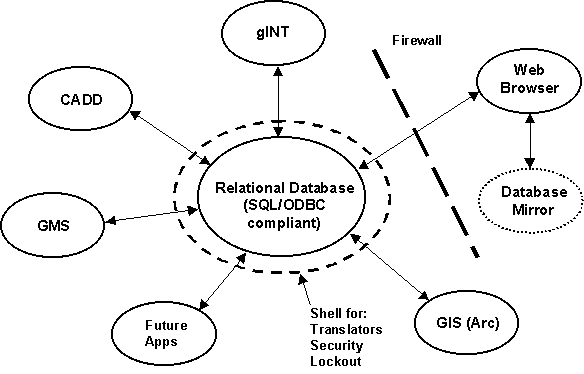
Figure 1. USACE Jacksonville District Geotechnical Data Management Implementation
The Jacksonville District needed an electronic data management system to make data readily available and easy to review, report, and utilize for model construction and analysis. Specifically, as depicted in Figure 1, the Jacksonville District was looking for a central relational database, SQL and ODBC compliant, to house and manage subsurface geologic field and sample data. The application had to have adequate security to enforce and promote data integrity, as well as integration and support of
Customizability and extensibility was necessary to support future integration with additional reporting and modeling applications. Finally, it was desired to make the data accessible outside of a firewall via a web browser.
At the recommendation of the U.S. Army Corps of Engineers Waterways Experiment Station (WES) in Vicksburg, MS, the Jacksonville District chose EQuIS Geology as the data management system to meet their needs in managing and using C&FS data. The model preferred for populating the EQuIS system is importing data directly from gINT files. While alternative methods may be used for loading the reams of historical hardcopy data, the District requires all new data submitted to be in the gINT format.
As with the restoration of the Everglades, the effort to migrate data from paper records in boxes, filing cabinets and warehouses into EQuIS so that it is accessible and usable for use in CERP is just beginning. To this point, a pilot project has been populated with borehole, well, and lithology data. A considerable amount of work is required to establish references, valid values, and protocols which will continue to make EQuIS a successful part of the overall restoration of the Everglades.
South Weymouth Naval Air Station
The South Weymouth Naval Air Station (NAS South Weymouth, or NAS SOWEY) is located in eastern Massachusetts, 15 miles south of Boston and six miles from the Atlantic coast. During its operation, NAS South Weymouth was utilized for airfield operations, safety and clearance zones, and aircraft support. The site was placed on the National Priorities List (NPL) in May 1994 with a Hazard Ranking System (HRS) score of 50.00 due to known or potential groundwater contamination. A Phase I Environmental Baseline Survey (EBS) was completed in 1996, and the Air Station was closed on September 30, 1997, in accordance with the Department of Defence Base Realignment and Closure (BRAC) Commission's 1995 Base Closure List. Within its 1,400+ acres, twelve sites have been identified for potential cleanup, four of which are closed or are currently undergoing remediation.
The Phase II EBS Work Plan was initiated based on the results of a Phase I EBS investigation conducted during October and November of 1995. The final Phase I report identified 94 potential Phase II EBS Review Items as potential environmental concerns. After further review, the BRAC Cleanup Team recommended 53 Review Item Areas for further investigation under the Phase II EBS. The primary goal of the Phase II EBS field investigation is to obtain analytical data at the 53 proposed Review Item Areas so that the environmental conditions of these areas can be evaluated and appropriate action can be taken. A second goal is the characterization of the water quality of aquifers located under NAS SOWEY.
Several types of environmental data collected from the South Weymouth Naval Air Station, including soil (both surface and subsurface), groundwater, surface water and sediment chemistry as well as geologic information were loaded into EQuIS Chemistry and EQuIS Geology. Unvalidated laboratory electronic data deliverables (EDDs), consisting of over 100,000 data records, were received by EA Engineering’s Data Management team and evaluated for completion and accuracy. The verified EDDs were then manipulated into an EQuIS import format and sent to the data validator for data reduction and EPA Region I - Level II data validation. These EDDs were also imported into an unvalidated EQuIS Chemistry database. The validated EDDs were then returned to EA Engineering to be incorporated into the final validated database. Location, water level, well, and piezometer type data were received electronically as Excel spreadsheets and entered into EQuIS Geology.
Once the databases were complete, data reporting and visualization software tools were used to support the project. The chemistry database was queried by Review Item Area to create summary tables as well as tables of analyte detentions compared to criteria. Well construction diagrams are created through predefined exports from EQuIS Geology to Rockware’s LogPlot. An ArcView GIS project was also initiated for spatial presentation and analysis of site data. The ArcView GIS project was used to create a series of views and layouts showing the locations of each Review Item Area for a client presentation.
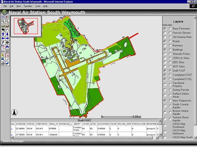
Figure 2. Naval Air Station South Weymouth ArcIMS Web Site
For greater access and availability, ArcIMS has been used to post and present data relative to the NAS South Weymouth on the Web. The site, http://weymouthnas.eaest.com, summarizes visually the results of the ongoing investigation and remedial planning.
Camp Ripley
Camp Ripley is a state-of-the-art military training facility in central Minnesota, about 100 miles northwest of the Minneapolis/St. Paul metroplitan area. Funded by the National Guard Bureau (NGB) and administered by the Minnesota Department of Military Affairs (DMA), Camp Ripley trains domestic military units from both active and reserve forces as well as foreign units from Canada, Great Britain, Norway, and the Netherlands. Situated on 53,000 acres west of the Mississippi river, Camp Ripley is designated the National Guard Primary Winter Training Site in the continental United States.
As with any other large military facility, the camp’s training and maintenance facilities carry with them an environmental responsibility. One of the missions of Camp Ripley is to partner with local communities to foster cooperation and facilitate economic growth. This objective necessitates the protection and preservation of natural resources, including water resources. The Integrated Natural Resource Management Plan (INRMP) includes programs for conservation, ecosystem, forest, land use, wildlife, and pests; however, a more robust, comprehensive strategy was needed for subsurface environmental concerns and proactive water resource management.
The DMA contracted with the University of Minnesota Duluth, Geological Sciences Department to come up with a management plan for geologic and associated analytical data as well as water chemistry information. The plan required a core database for managing data, a user interface for accessing and viewing data, the capability to integrate with modeling and analysis tools, and a GIS component for presentation of the data. Since 1999, Benjamin Bertsch, Senior Scientist at the UMD Geological Sciences Department, and his team have been developing the foundation for water resource management tools to be used at Camp Ripley. This set of tools, founded on EQuIS, and the processes that drive them, are referred to as the Comprehensive Water Management Plan (CWMP). Like the other components of Ripley’s INRMP, the CWMP assures maximum use for the military while minimizing ecological costs. Unlike the other components, however, the CWMP developed by Bertsch focuses on making data and science accessible to managers for integration into their daily tasks.
Typical of many site characterization/investigation projects, a three-phase implementation has been proposed. Phase I involves the assimiliation and conversion (where necessary) of historical data into a consistent and usable format. Using data collected and managed in EQuIS, a characterization of the conceptual hydrologic flow systems is made and used to construct basic groundwater flow models. Phase I establishes the framework for building the CWMP. Phase II evaluates information previously collected and recommends additional data collection where necessary, ultimately to enhance and improve the accuracy of flow models. Phase III integrates the data, scientific processes, and computer models and tools to deliver a usable product to resource managers. Specifically, proposed deliverables include
Present Status
Currently, Phase I of the Camp Ripley CWMP is nearing completion. Over 60 reports have been read and catalogued, with relevant information extracted and entered into EQuIS. More than 250 environmental borelogs and well construction reports have also been loaded into EQuIS, in addition to 275 well logs for the area immediately surrounding Camp Ripley. Over 3,000 analytical results have been entered as well. Managing this data in EQuIS has made it readily available for modeling and GIS analysis.
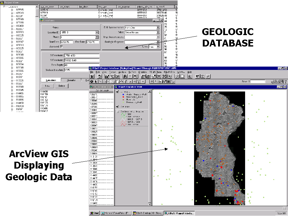
Figure 3. Camp Ripley Geologic Data in EQuIS and Displayed Spatially In ArcView GIS
Figure 3 shows an example of how data may be managed in EQuIS and how it is accessible through GIS. The photo shows the boundaries and spatial extent of Camp Ripley. Once properly loaded, the EQuIS ArcView Interface facilitates automatic display of borehole and well locations. In addition to being able to easily identify the properties or attributes of each well, the Interface includes capabilities to view the lithology at any borehole location, to create a report-quality borehole log in either LogPlot or gINT, two create 2D cross-sections in RockWorks, and to view the site in three dimensions in either Esri’s 3D Analyst, GMS, or CTech’s EVS.
In Figure 4, hydrostratigraphic data, or the aquifer-aquitard relationship, for each borehole location was exported to GMS through the EQuIS ArcView Interface. The appropriate locations were selected in ArcView, and then the data were queried out of the EQuIS database and written to GMS borehole files. GMS was launched and the borehole files loaded. Subsequent interpolation defined this sand/till model. In Figure 4, the red-colored material represents sand or highly sandy layers. Clay and sand mixtures are colored green, and clay-rich tills are not shown.
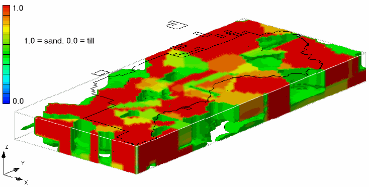
Figure 4. Camp Ripley Hydrostratigraphy model in GMS
In addition to the geologic modeling, analytical results stored in EQuIS were used for reporting and analysis. Figure 5 shows observed analytical results for chloride from 1993 to 2000 in monitoring wells at the Demolition Debris Landfill.
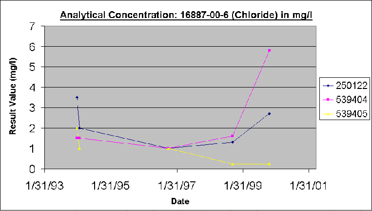
Figure 5. Chloride trend in Demolition Debris Landfill Monitoring Wells
Application: Landfill Spread Site
An application of the geologic and analytical data stored in EQuIS as part of the CWMP for Camp Ripley is the siting of monitoring wells at the Landfarm Spread Site. In conjunction with Liesch and Associates, the UMD Geological Sciences Department used existing data to propose locations for both upgradient and downgradient monitoring wells at the site to characterize water quality prior to and during operation. To accurately and correctly place the new wells, at least three factors needed to be considered: groundwater flow, geology, and estimated depth to water.
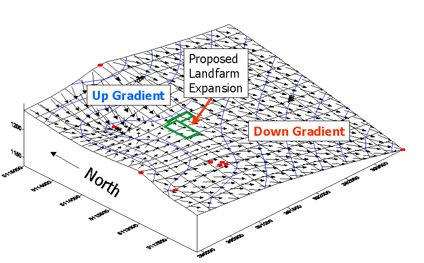
Figure 6. Groundwater Flow at the Proposed Landfarm Expansion Site
Water level elevations observed during the construction and sampling of nine monitoring wells surrounding the proposed site were stored in EQuIS Geology. Using the direct interface to Surfer, a mapped elevation contour was produced showing the potentiometric surface. Illustrated in Figure 6 (existing monitoring wells displayed as red dots), the groundwater flow was determined to flow from the northwest towards the Mississippi River in a southeasterly direction.
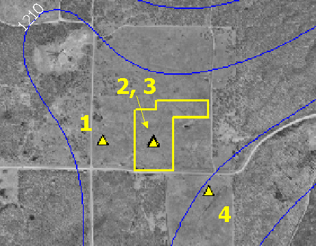
Figure 7. Proposed Well Placement
Based on the results of the groundwater flow analysis, the proposed wells were sited as shown in Figure 7. Well #1 shown to the left is west and upgradient of the expansion to capture background water quality data, prior to contact with the Landfarm. Wells #2 and #3, capturing water quality within the site, are towards the center of the expanded area. Well #4, shown in the bottom right, is downgradient with the purpose of characterizing the quality of water leaving the site. In addition to determining the proper location spatially, the proper depth of well and screened interval needed to be determined. Using borehole data logged during the drilling of the existing wells stored in EQuIS Geology, a local model similar to Figure 4 was developed. This three-dimensional hydrostratigraphic model provided insight as to the depth and distribution of water bearing units. Surficial sand-rich deposists were estimated to extend to a depth of about 80 feet, where they transitioned to a clayey confining unit. The upper unit was assumed to be a localized, shallow aquifer, while a regional aquifer existed below the confining unit. Wells 1, 2, and 4 are to be screened in the shallow aquifer, while Well 3 will be screened in the deeper regional aquifer.
What has been demonstrated with the example of monitoring well placement for the proposed Landfarm expansion at Camp Ripley is fairly typical of a groundwater investigation. However, the primary benefit of the CWMP is that it is a proactive, rather than a reactive, solution. This can result in a significant savings in time and, potentially, millions of dollars.
A brief comparison is made with the Massachusetts Military Reservation (MMR). The MMR is a 21,000 acre military training facility on the upper west area of Cape Cod. Established in 1911, the base has been used for military training since 1935. From 1955 to 1972, Air Force operations included the use and generation of hazardous products such as motor oils, fuels, and cleaning solvents. Typical of the practice of the day, these materials were disposed of in landfills, drywells, sumps, and the sewage treatment plant. The MMR sits atop the Sagamore Lens, a 300-foot thick aquifer with permeable sandy soils. Currently, there are 15 known contaminant plumes originating from MMR. To date, over $400 million of an estimated $850 million has been spent on the cleanup project.
When contamination was first discovered at MMR, it is likely that no proactive water management plan was in place. Essentially, a Phase I and Phase II process, including characterization of the hydrologic system, modeling, remediation, and monitoring had to be conducted in a short time span and at great expense. There was little integration of geologic and analytical data. The conceptual and dynamic modeling process had to start from the beginning; remediation activities were eventually based upon these models.
Lessons have been learned, and the CWMP developed by the UMD Geological Sciences Department is expected to facilitate much more expedient and cost-effective investigation, should the need arise, at Camp Ripley. Existing data is already compiled and accessible. A baseline hydrologic model has been constructed, and could be refined locally with only a few properly sited boreholes. A dynamic flow model is available. Using the tools and data made available as part of the CWMP ensures that decision-makers have the most accurate information easily accessible when reactive management issues need to be addressed.
Conclusion
EQuIS has been implemented or is currently being utilized in many different environmental remediation and restoration projects at military installations and other facilities around the world. The projects highlighted in this paper serve as examples of the benefits of implementing a database system such as EQuIS. With the storage of data in one centralized repository and the ability to export this data to many different evaluation tools, site characterization and analysis becomes quicker and more effective. Decisions can be made based on the data with much more confidence and reliability. The ease of data query and export to evaluation tools afforded by EQuIS allows project managers to test the sensitivity of different applications to the data.
Environmental Data Management, site remediation, water quality analysis, chemical contaminant assessments, and more—is a complex process which may involve several organizations participating in data collection, assessment, and evaluation of the information. Engineering consultants and military environmental commands; Army Corps of Engineers and water management districts; even cutting-edge education institutions….all of these entities can work cooperatively to standardize and implement a successful data management system which ultimately facilitates better decision making.
Acknowledgements
Many thanks to the following individuals who provided information, assistance, and proved an invaluable resource in the writing of this paper:
John J. Hyde, WR-ALC/EMX