 |
Keywords: GIS Analysis, Transportation, Environmental Evaluation, Environmental Impact, GIS Application
- Contemplation of the study with federal goals and plansIn addition to the above criteria, FDOT Environmental Management Office added a number of other criteria that address the potential impact of the proposed transportation corridors on the community. Some of these criteria include:
- Intersection or adjacency of the corridor with conservation lands
- Intersection or adjacency with critical and strategic habitat
- Intersection of adjacency with 100-year significant flood plains
- Consistency of the drainage alterations with the watershed management plans
- Impact on significant wetlands
- Impact on significant natural resources
- Access to barrier islands or access to Coastal High Hazard Areas
- New access or increased capacity to non-urbanized areas
- Breaking of the community cohesion by dissecting community boundariesOther important additions to this category are the criteria that concern potential impact on historic features including:
- Reduction of access between various community activities
- Impact on special populations such as elderly, low income, minority etc
- Impact on Ĺcommunity significantĺ areas
- Impact on the economic stability of the community
- Historic and archaeological sites of Federal, State or local significanceBased on the criteria above the GeoPlan Center at the University of Florida developed for FDOT the Environmental Analysis Screening Tool (ESAT), a GIS-enabled application that implements the screening guidelines. ESAT is developed as a tool that would assist transportation specialists to quickly identify the potential significant impacts early on in the planning phase of the project and prioritize the subsequent detailed analysis.
- Officially designated State Historic Highways
- Historic bridges
- Parks, wildlife refugees
|
|
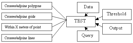
Figure 1. "TEST" structure.
A ĹTestĺ is a function that allows identifying the spatial relationship of the proposed corridor with the geographic data layer. For example to answer one of the criteria questions ĹAre there wetlands of regional significance in the corridor area?ĺ the application calls a GIS function that determines if an intersection exists between the corridor layer and the wetlands layer. If the result is positive a numeric indicator that quantifies the impact is reported. In the example above it will be the number of acres of the wetland inside the corridor. The application employs the following spatial operations to measure the impact:
- Crosses/adjoins polygon featuresFor the criteria that are not affected by the spatial relationship a map is provided for visual inspection.
- Crosses/adjoins grid (raster) features
- Comes within X meters of point features
- Crosses/adjoins line features
To determine whether the outcome is critical or not two default values are used as thresholds. If the outcome is higher than the highest value than the impact is determined to be severe. For values between the thresholds the impact would be moderate and below the smaller threshold value the impact is insignificant.
Another variable defined with the ĹTestĺ is the desired output that include the map, legends, labels etc.
Any criterion can contain one or more tests. The criteria are grouped
in categories. For any given study the criteria category, the criteria,
the project corridor, the tests for each criteria and the parameters for
each test are variables and can be combined in various ways to allow maximum
flexibility.
Software component
For the implementation of the application the development team selected
to use ArcView 3.1 or higher as the base GIS software and used ArcViewĺs
Avenue programming language for the automation of the analysis and the
interface customization. The application was packaged as an ArcView extension,
a solution that would allow the maximum use and deployment flexibility.
All the spatial analysis described in the application structure above have
been automated including both vector and raster geographic data. The later
requires Spatial Analyst, Esriĺs extension for GIS raster data.
The complex interrelationships of the various organizational and functional components such as the study area, corridors, criteria, tests, test parameters etc., were compiled in tabular form using MS Access database system. The Entity Relationship diagram is fully normalized allowing maximum expansion flexibility and application control integrity. The inherent link of forms and tabular data in Access allows simpler and quicker customization. In addition, the decision to store these relationships in a RDBMS instead of a flat file system was also made to anticipate a sound web implementation of the application, which is currently under development.
The link between ArcView and MS Access is established by using the ODBC and Dynamic Data Exchange (DDE) technology supported by both ArcView and Access.
The outcome of the analysis is automatically created in two commonly
used formats: MS Word and HTML. Using DDE, ArcView sends to MS Word all
the results including text and graphics. The Word report can then be printed
and used in addition to other project documentation. The report in HTML
format is written programmatically using Avenue and the files are organized
in a structure suitable for web publishing.
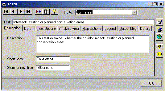
All the details of the analysis are already setup in tabular form in Access.
Default parameters are stored for most of the analysis components. However,
the analyst can change most of these parameters. The interface for modifying
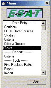
the analysis settings is provided in Access forms. Using a menu (figure
2) the user can select to change the type of analysis, proximity area,
buffer sizes for affected areas, impact threshold values for low, medium
and high degree of impact, datasets to be used, query expression that selects
the attributes of interest and a number of parameters for map display and
report making (figure 3). To enable users share their customized
analysis the application contain an export/import feature available in
Access interface (figure 2).
 |
 |
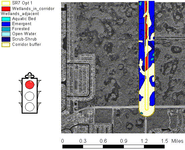
The final report contains the study area map, an executive summary,
and the results of each test (figure 4) with the numeric indicator of the
size of the impact, details for the attributes of features impacted and
a traffic light graphic icon showing the severity of the impact. The HTML
report is build with a left and right frame for easy navigation whereas
the MS Word report is built in a traditional linear fashion.
| State Road 7 Extention - Option 1
There is 868.5 acres of wetland areas within 500 ft of the corridor. Source: National Wetland Inventory. |
 |
 |
Figure 4: A page from the report generated by ESAT; The numeric indicator is shown on top; The map with the traffic light indicating the level of severity is shown in the middle; The details of the analysis are shown at the bottom. Note that the map shows only a part of the 9 miles long corridor whereas the indicators apply to the whole 9 mile long corridor. The example take from a pilot study area in Palm Beach county, Florida.
On the flip side of this flexibility, one must remember that the quality of results produced by ESAT will only be as accurate and up-to-date as the data used. For example, statewide habitat coverage digitized at 1:100,000 may be only accurate to within 500 feet. This may be fine for large-scale analyses, but may result in a high margin of error when trying to determine habitat impacted by a 220-foot wide corridor. Likewise, a census coverage that is ten years out of date will likely underestimate any demographic measures for community impact assessment.
Currently the research team is focused in extending ESAT from a screening tool into a decision support system with the ability to determine the least impact alignment based on the user criteria priority. This would allow identifying alternative routes that minimize the environmental impact according to the user special conditions. A second current effort is directed into web enabling of both the current screening capabilities and the best route selection extension. A number of map server technologies have been explored so far and the present effort is focused in using Esriĺs ArcIMS as a technology that allows the flexibility that ESAT requires to be ported to the web.
Frerichs W.N., West J.R., "Using GIS to streamline and improve highway planning and design", Roadway Design, CE NEWS online, November 1998
Gilbrook, M.J., "Finding the Appalachian Scenic Corridor"
Governor's Office, State of Florida, 1999. Guidelines to Address Secondary and Cumulative Impacts in the Planning and Project Development Process. Tallahassee, Florida.
Sadek, S., Bedran, M., Kaysi, I., 1999. ôGIS platform for multi-criteria evaluation of route alignments,ö Journal of Transportation Engineering, Vol. 125, No. 2, March/April 1999. pp. 144-148.
US Department Of Transportation, 2000. ôEnvironmental Streamliningö, Federal Highway Administration ľ Planning, Environment and Real Estate Services. http://www.fhwa.dot.gov/environment/strmlng.htm.
Zura, M., Lipar, P. 1995. ôThe road and traffic environmental impact statement and optimal room layout selection,ö in 15th Annual Environmental Systems Research Institute User Conference Proceedings. Environmental Systems Research Institute. Redlands CA. http://www.Esri.com/library/userconf/archive.html.
Author Information:
Ilir Bejleri, Ph.D.
Assistant Professor and Applications Development Manager for GeoPlan
Center
Department of Urban and Regional Planning
University of Florida
431 Architecture Building
Gainesville, FL 32611
Phone: (352) 392-0997 ext. 432
Fax: (352) 392-3308
Email: ilirbeu@yahoo.com
Paul Zwick, Ph.D.
Associate Professor, Department Chair and GeoPlan Center Director
Department of Urban and Regional Planning
University of Florida
431 Architecture Building
Gainesville, FL 32611
Phone: (352) 392-0997 ext. 427
Fax: (352) 392-3308
Email: paul@geoplan.ufl.edu
Andrew Lyons
University of California at Berkley
Email: filijee@yahoo.com