GIS staff can spend significant time making maps for internal and external customers. This can take time away from other important functions such as maintaining and enhancing data. Moreover, a backlog of mapmaking jobs can increase turnaround time to days or weeks. Jackson County, Oregon, and GeoNorth, LLC, will talk about the managerial and technical aspects of a Web-based system they developed to automate and streamline Jackson County's map production process. This solution enables non-technical users to drive AML scripts from a Web form. It utilizes ArcIMS or , ColdFusion, Perl, and a shared database model.
|
|
|
Jackson County is the sixth most populous county in the State of Oregon. Jackson County covers more than 2,801 square miles � making it equal in size to the state of Delaware. The current population is 174,550.
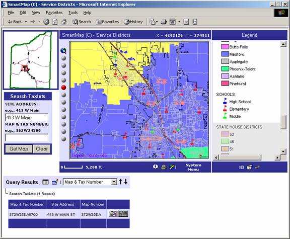
While Jackson County GIS Services has served both residents and internal departments with several interactive mapping applications over the last few years at their registered domain web site �SmartMap.org�, this has not fulfilled the consistent demand both internally and externally for large, high-quality cartographic maps.
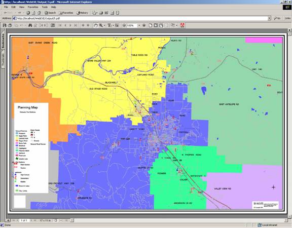
The cost of a cartographic map generation at the county is $75 for all services (media, staff time, etc.) It is the same price whether it�s an 8 �� by 11� black and white vector map or a 35� by 48� color map with aerial photos.>Unlike the interactive mapping sites, the order fulfillment doesn�t happen in seconds or even minutes. The map request gets �queued� with a GIS technician for production at a later time or even a later date.
In most GIS shops, programmers have written Avenue, AML, or VB/VBA scripts to automate ArcView or ArcInfo map creation using page layout templates and pre-defined map or legend rendering. For some common map requests, a GIS technician may need to tie up their machine resources running a previously developed script and template that requires their interaction to run and print, but no extra interaction for page layout or cartographic development. The result is a hardcopy map that cannot be reproduced without re-running the script with the same user input or retaining the output in some re-usable format (graphics file, postscript file, etc.) This saved copy would only display the GIS data as it existed at that moment.
If the user wants a digital version, then typically the output format has to be converted to something they can use (like a graphics file, assuming they have ArcInfo, or a PDF, which might require each GIS workstation to have a conversion utility like Alchemy or some of the newer output options with ArcInfo 8.)The output is typically more than will fit on a floppy disk, so a CD-ROM writable media must be sacrificed. E-mail is an alternative, but the size can often be troublesome with mail server constraints.
The project goal for the �Maps on Demand� project was to
The achievement of this goal required an easy-to-use, light-weight front-end interface that would work in Internet Explorer or Netscape. It also required an output format that could be viewed in the browser or in a document format that was suitable for printing. The output formats selected for the initial implementation were PNG and JPEG for the browser-viewable output format and PDF for the document format.
The solution chosen for this project was the existing smartmap.org front-end powered by MapOptix. MapOptix is a 3-year old IMS product that utilizes both MO/IMS and ArcIMS for Internet maps and a thin client front-end using Cold Fusion to link GIS and tabular Databases. The back-end used to produce printable cartographic maps was Workstation, and Image Alchemy to create PDF output. GeoNorth developed and deployed the architecture, a web-based front-end interface for submitting map requests, and a web-based interface for map job administration. All three of these will are detailed in order.
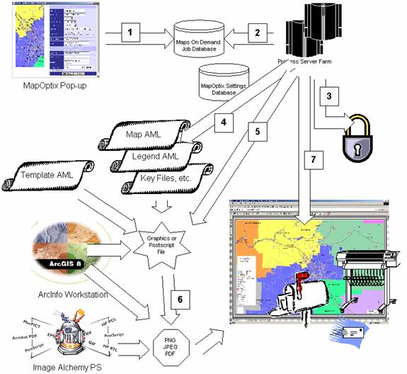
The architecture used for the Maps on Demand project was a combination of Internet, GIS, and Database technologies. All communications and configurations between the back-end components are implemented using shared databases. There are two primary databases. One is the MapOptix �settings� database used for all of the map images (layer rendering, layer ordering/thresholds, etc.) and one is the Maps on Demand �jobs� database, used for all of the actual map requests.
The MapOptix �settings� database publishes cartographic information to MapObjects, ArcXML, and AML. This is an Access database at Jackson County. This data model also is supported in Oracle and SQL Server, and it has been ported to PostgreSQL.The Maps on Demand �jobs� database is primarily a �queue� of jobs (optionally processed in a �batch�) that are fulfilled by one or more back-end processes on one or more back-end servers. The jobs are all based off of a pre-defined �process� definition, which constrains the input and the location of the software that is �executed� on the back-end. All jobs, their arguments, their current �state�, and all state changes are logged as the jobs is executed.
Below is an example of how this architecture is implemented as a job goes from creation to completion. The numbers at each step are detailed following the diagram.
Once the user has an extent, map scale, and layer selection that they are satisfied with, they click on the �Make Map� button to display the below interface.
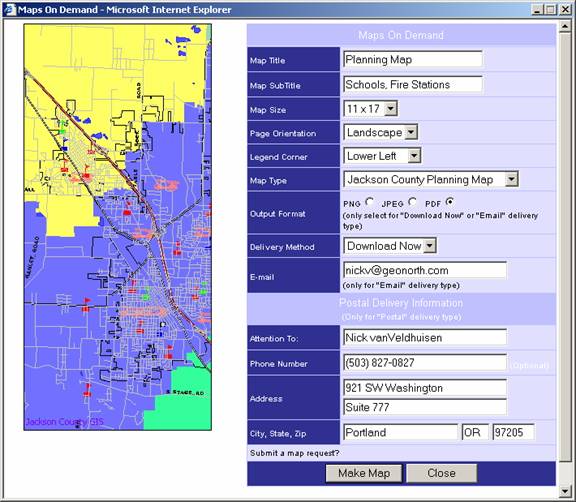
The user has a preview of the map exactly as it will look on the back-end, and
can enter their own title information, the page size they would like, the
format of the output they would like, and the method of delivery.
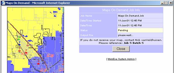
The below screenshots show
the immediate response from the job submission (updated every few seconds with
JavaScript to show the job state transitions) and the job submission output.
The job management web interface controls all aspects of the application, including:
As you can see in the below screenshots and descriptions, this architecture could apply to any command-line based process that a user wanted to run from the web that resulted in printable or digital output.
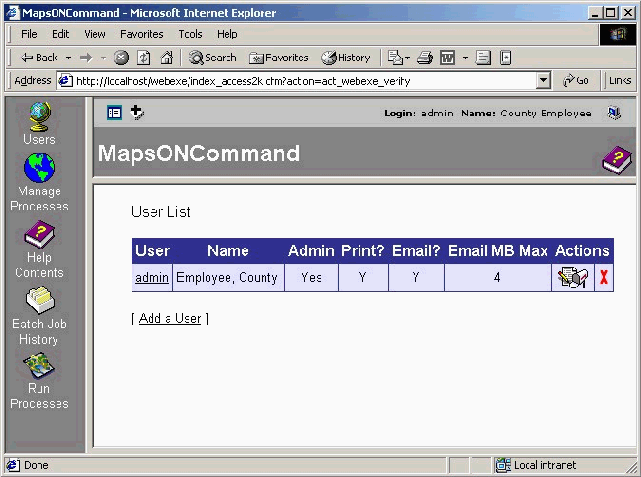
User Management
User management includes username/password, general contact information (used to populate the �popup� map job submission form,) administrative permissions, and the methods of delivery the user can request. In the case of e-mail, there is a �cap� on the size of file that can be sent. On-site print requests can be disabled or enabled. Any immediate download can be HTTP or FTP, and can reside on remote servers.
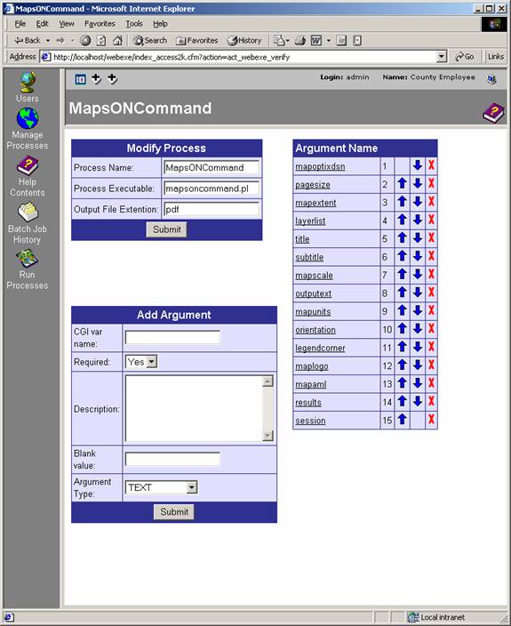
Process Management
The definition of a process includes the process executable (in this case, a Perl script,) the name of the process, and the arguments to the process. Argument order is the order sent to the command-line on the back-end. Arguments include the argument type, description, �default� value, and a flag to specify if the argument is required or not.
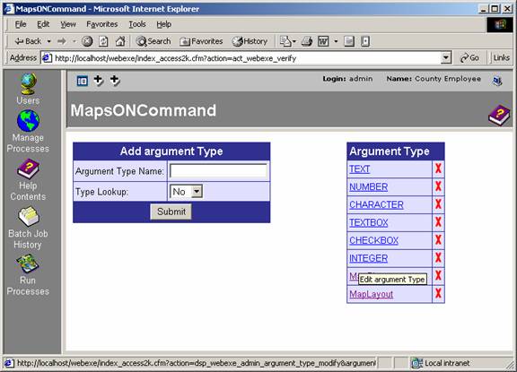
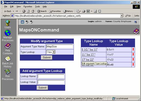
Argument Type Management
Each argument has a �type�. This includes standard input field types (checkbox, text, text area) as well as the type of argument it is (integer, number.) There is a lookup definition interface for select boxes (used here for map size and layout.)
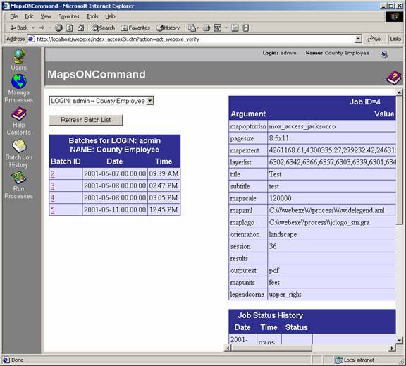
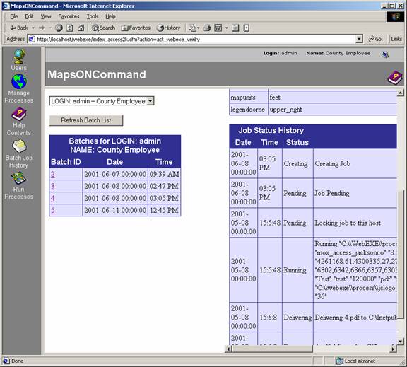
Job History
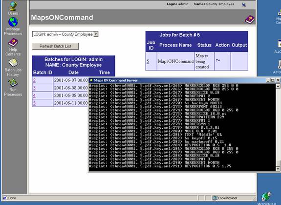
Each job keeps track of the arguments sent to it and its state transitions. If the MapOptix settings and job definition have not changed, a job can be �re-submit� for creation. The job detail and re-submission (with the process running in the foreground) are shown in the below screenshots.
There were some definite lessons learned during the course of developing this technology. Many of these lessons have probably been published by programmers that have dealt with mainframe or service-level software for the last 20 or even 30 years. They are listed below
Nick vanVeldhuisen
Portland Office Technical Manager
GeoNorth, LLC.
921 SW Washington
Suite 777
Portland, OR, 97205
P: (503) 827-0827
F: (503) 827-0735
E: nickv@geonorth.com
I: http://www.geonorth.com