PSC is working with the Emergency Manager's of three Southern Maryland counties; Calvert, Charles and St. Mary's which have been designated as "Project Impact Communities". The counties have received a grant from FEMA to assess and implement disaster prevention strategies. PSC is integrating MaxResponder with the capabilities of EM2000. It will be brought into the Emergency Operations Center and to the Naval Air Station, Patuxent, Maryland to consolidate, administer, and share the regional GIS information. GIS will be utilized by the EOC's to perform contingency planning & mitigation and will provide a key component in accelerating response by fire, police and emergency personnel.


A hurricane is rapidly moving up the coast and is targeted for your area. Its expected landfall is in 24 hours. Who's at risk? How many people live in the area? What are the locations and types of hazardous materials in the region? How many homes could be flooded when the hurricane hits? These are critical questions, which require immediate data and an effective communication network. Due to the increased occurrences of major natural disasters and global threats, the need has arisen to incorporate existing systems and data into advanced tools for a more comprehensive incident response and recovery. PSC is currently working with the Emergency Manager's of three Southern Maryland counties; Calvert, Charles and St. Mary's which have been designated as "Project Impact Communities". Under the coordination of the Tri-County Council, the counties have received a grant from the Federal Emergency Management Agency to develop a prototype Integrated Emergency Management capability to share data and capability across the counties to effectively manage emergency situations that span the Southern Maryland region. The information technology and needs of this effort were immense. The development of a common emergency management capability in the Tri-County area will support planning, response, exercises drills, and modeling, as well as emergency management and emergency operations center activities in the counties and the co-located military bases.
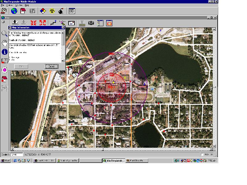
PSC developed the software application Max/EM for the Emergency Operations Center to consolidate, administer, and provide easy access to the regions information. From the Max/EM Home page, the local Emergency Managers of the tri-counties can with a single keystroke or "hot key" access the information stored in Max/EM. They can view the situation graphically to make informed decisions as to who or what may be at risk. This is essential to the advance planning and preparation crucial to minimizing the risks to life and property in the area.
The key to information management solutions is building a "Shared Data Vision" which incorporates integrated data management around an enterprise geospatial server. This requires links across departmental lines through communication, common applications and databases, and through the sharing of common incident management information. PSC has worked with the GIS personnel to develop a common geospatial database for the Max/EM application. The database sources were integrated into a common database for incorporation into spatially enabled information management system. GIS will be utilized by the Emergency Operations Centers to perform contingency planning & mitigation and will provide a key component in accelerating response by fire, police and emergency personnel. The integration of GIS data at minimum requires:
| Data | Thematic Content |
|---|---|
| Boundary | Politicaland administrative jurisdiction |
| Geodetic | Benchmarks and survey control |
| Hydrology | Rivers, lakes, and other inland water |
| Image | Ortho-Rectified Arial Photography, or Satellite Multi-Spectral |
| Land Form | Topography, geology, and soils |
| Land Marks | Geographic places and public buildings, or areas |
| Land Use | Urban, agricultural, forests, wetlands etc. |
| Structures | Buildings footprints and other urban features |
| Transportation | Roads, railroads, and support infrastructure |
Because of the national perspective FEMA brings to the Project Impact Initiative, local fire and law enforcement are also evaluating data integration, management, and accessibility. Max/EM is a dynamic threat/hazard modeling tool and utilizes local and institutional databases, the Earth Alert system from NAS, GNOME for oil spills on water and other modeling programs to run predictive damage and casualty models. Max/EM also has embedded specialized databases to identify and protect critical infrastructure in natural and manmade disaster management. These components are essential for effective disaster avoidance and response. MaxResponder™ incorporates the North American Emergency Response Guide (NAERG) and the Chem-Bio and Improvised Explosive Devices (IED) handbooks. These guides are fully integrated into the application for analysis, data sharing and integrated operations.
The basic functionality of the Max/EM System includes:
Advanced capabilities that are also required are:
MaxResponder provides a comprehensive solution for natural and made-made disaster management requirements. Any rail, highway, airport or support system, which transports people or goods, must be protected. To accomplish this, first responders must be provided with a solution that can be implemented across cities, counties, states or large regional areas for the sharing of information and assets to respond to emergency situations