WebGIS as a teaching tool
Marco PAINHO1, Miguel PEIXOTO2,
Pedro CABRAL3 and Ricardo SENA4
Institute for Statistics and Information Management
New University of Lisbon
Campus de Campolide – 1070-124 LISBOA – PORTUGAL
Telefone:+351-21-3870413; Fax:+351-21-3872140
Abstract
This paper addresses the concept and process of using
WebGIS as a teaching tool in Higher Education GIS curricula.
The use of WebGIS is becoming an important tool to teach GIS concepts
but most of the GIS core curricula available in Higher Education
still do not include this new way of using geographic information.
This situation leads to a gap between the GIS market expectations and the
skills of recently graduated students that start seeking for a GIS job.
The focus will be a proposal for a new topic to be included in Higher
Education GIS curricula and to review some of the WebGIS projects
developed using ArcIMS by the students at ISEGI-New University of Lisbon (Portugal).
1. WebGIS: What is it?
There are a lot of different definitions for GIS.
This is due to the several different fields of application of GI Science. To
define WebGIS we can use the same definition we use to define GIS but we need
to add the web component to it. Our proposal to define WebGIS is as follows:
A
complex system with access to the Internet, for capturing, storing,
integrating, manipulating, analyzing and displaying data related to locations
without the need of having proprietary GIS software.
In fact the Internet does not change the fundamental nature
of GIS, it just gets it online expanding its use (Harder 1998). But we cannot
forget about the multiple advantages of using GIS on the Web. The Internet and
the growing number of users all over the world in the last years made it
possible to start using new ways of information dissemination. It all started
with the exchange of simple documents or data files but then evolved to the
offer of several types of applications running on the web. GIS data and
technology also collected important benefits from this evolution. Nowadays it
is much easier to find and disseminate GIS data using the web than it used to
be some years ago. There are a lot of new websites that facilitate the access
to a great variety of data producers. What about GIS applications on the Web?
There are also a great number of WebGIS sites that allow to perform GIS
operations using only an internet browser. It all started in 1993 with Xerox
PARC Map Viewer (still available at
www.xerox.com/map)
but things have changed a lot since then, such as the Internet and GIS
technology did. WebGIS is not only displaying geographical data on the web but
also using some GIS functionalities (see WebGIS definition). With the recent
developments on WebGIS technology, Internet users are now able to access GIS
applications from their browsers without purchasing proprietary GIS software
(Figure 1 and 2).
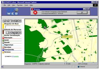
Figure 1 Network analysis on the Web (www.geoweb.pt)
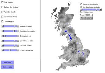
Figure 2 Where to Dispose of Britain's Radioactive Waste?
Open Spatial Decision Making on the Internet
(www.ccg.leeds.ac.uk/mce/mce-init.htm)
The strategies for delivering geographical
functionalities using the Internet also evolved from pure server-side
applications to client–side applications with a significant increase on the
number and power of the available analysis tools to the user. Both server-side
and client-side strategies have advantages and disadvantages. If on a pure
server-side strategy we may have serious performance problems because of the
bandwidth and network traffic or the server that is being used, on a
client-side strategy the response from the server may involve transferring
large amounts of data as well as applets, causing significant delays (Keneth
& Kirvin, 1997). On the other hand if a high-performance server is used on
a server-side strategy, users can access large amounts of data that would be
difficult or impossible to transfer across the Internet and process locally on
the client. Although these applications take advantage of the processing power
of the user's own computer in a client-side strategy and the user can be given
greater control of the data analysis process sometimes is very difficult for
the user to be aware of those analysis tools and to know how to use them
effectively (Keneth & Kirvin, 1997). We also need to be aware that most of
the users do not want to wait several minutes for the download and installation
of plug-in software required to use this type of applications. One of the
biggest advantages is that once the server has delivered its response, the user
can work with the data without having to send and receive messages across the
Internet. The ideal situation is a strategy that can optimize the advantages of
both client-side and server-side strategies and minimize their disadvantages
(hybrid strategy).
2. Why use WebGIS in Higher education
It is fundamental to teach
WebGIS at all GIS courses. The technology that underlyes GIS is permanently
evolving and the internet is where GIS technology is heading. GIS courses cannot
neglect the potential of using WebGIS not only to teach the advantages of using
GIS and its principles but also to teach how to implement a GIS using web
technology. Maybe the biggest advantage of using WebGIS in GIS courses is
showing the potential of some professional WebGIS applications and use them to
communicate the advantages of using GIS. Of course this is not enough. The GIS
job market expects that students from GIS courses know not only the principles
of GIS and how to use GIS software but also to know how to implement a WebGIS
site. This is the main reason why we have decided to include a WebGIS topic in
GIS course at ISEGI-UNL.
3. The teaching of GIS at ISEGI-UNL
We started our work in this field back in 1991 with
an annual GIS seminar. This seminar evolved to a part of a unit of the two-year
degree. It then became a totally independent GIS unit included in the two-year
degree and in the MSc. Nowadays we have at ISEGI-UNL eight GIS-related units
with the following distribution:
- two GIS-related units for the two-year degree: GIS and Software Systems for Statistics and
Information Management;
- there are four GIS related units for the four-year degree: GIS, Geographical Concepts for
GIS, Informatics for Statistics & Information Management and Remote
Sensing;
- finally we have a specialization in Environmental, Demographical and Geographical
Information Systems for the MSc in Statistics & Information Management
that includes three units: GIS, Demographical Information Systems and
Environmental Information Systems.
Specifically for the four-year degree, some changes
were made to the curriculum in 1999. Now there is a GIS sequence that is
composed of three units: Software Systems for Statistics and Information
Management, Geographical Concepts for GIS and, GIS (project and management).
Besides being viewed in sequence, units should also
be regarded in relationship with other units that together make up a coherent
curricular experience, both within the structure of an undergraduate degree and
across the entire course taking of a student. At the end, course design also
needs to ensure that the students are given the skills for future professional
work (Painho, 1999).
The curricular structure of the degree offers a group
of fourteen other interdependent units (in three major areas) that can be
considered as the outer core of the GIS path in the degree in Statistics and
Information Management. Some of these units are in themselves cores of other
paths. This group of units is a complement to the core GIS curriculum and gives
students a strong background in essential areas such as data analysis and
processing, information and computing technologies and, information and
societal issues.
4. GIS (project and management) course topics at ISEGI-UNL
The GIS
project and management class is the last of the GIS path. It is an integration
class that is partially science, system and studies. It assumes knowledge from
the GIS core and outer core classes, especially geographic concepts for GIS,
software for Statistics and Information Management, database management systems and,
data analysis (Table 1) (Painho, 1999).
Geographic Information Systems (project & management)
SYLLABUS
(Weekdays and time of class)
| Prerequisites: |
None.
Geographical concepts for GIS, software systems for statistics and information management,
data analysis and, database management systems (concurrent), helpful but not required |
| Credit units: |
3 |
| Course description: |
This course is the last of a series of GIS courses. It is a theoretical and hands on
course geared towards applications and project management. Its theoretical emphasis is on
spatial analysis and management and implementation issues. |
| Course program: |
- Basic principles of remote sensing: images; principles of image classification
- Spatial analysis: spatial overlay; spatial search, network analysis,
terrain modeling, location / allocation; spatial interpolation.
- GIS implementation: GIS and the organization; implementation process, systems design.
- WebGIS
- Implementation management: managing transitions; implementing GIS applications; system management.
- Project.
- Field trip.
- Hands on ArcInfo ®: data input, editing and analysis
|
| Course objectives |
- Integrate GIS concepts with other disciplines;
- Ability to put GIS concepts to work.
- Ability to deal professionally with GIS problems.
|
| Course format |
Lecture with discussion, laboratory and field trip. |
| Reading materials |
Main textbooks:
- Huxhold, William E. and Allan G. Levinsohn (1995) Managing Geographic Information Systems Projects,
Oxford University Press
- ArcView, Spatial Analyst, Network Analyst and ArcInfo manuals.
- Class notes available on the internet course homepage. Has links to other sources of information for GIS.
|
| Evaluation |
One test and one group project. The project type must be chosen by the third week of the
semester. A list of project types will be made available. Limited data is also available.
Groups may not have more than 3 students. Projects are due at exam date.
Test is worth 30% and project 70% of the final grade. |
| Course outline |
- 1 – Course introduction
- 2 – Basic principles of Remote Sensing
- 3 & 4 – Spatial analysis
- 5 – Lab: ArcInfo data input;
- 6 – Project discussion;
- 7 – Lab: ArcInfo data editing; project outline due
- 8 – Spatial analysis
- 9 - Lab: Project
- 10 & 11 – GIS implementation
- 12 – Lab: Project
- 13 – Implementation management
- 14 – Field trip
- 15 – Test
- 16, 17, & 18 – Lab: ArcInfo data analysis
- 19, 20 & 21– Developing applications with MapObjects
- 22 – Implementation management (cont.)
- 23, 24 & 25 – Building WebGIS sites using ArcIMS.
- 26 - 28 – Lab: Project
|
Table 1 Geographic Information Systems (project & management) course at ISEGI-UNL (Painho, 1999)
The outputs of the group projects are:
- a website describing the project that includes a WebGIS link that is working in
ISEGI-UNL intranet. This webpage must include the data that was
used/produced for the project.
- a poster describing the objectives, methodology and analysis of the results of the project.
- a report describing all the phases of the project.
After this course students are able to implement a
GIS project starting from the data collection phase to the analysis and
development of user-taylored GIS applications. They also must be capable of
implementing a WebGIS website with all its implications.
5. Some WebGIS student projects at ISEGI-UNL
Here are some projects
developed by students at ISEGI-UNL that were published on ISEGI-UNL intranet:
5.1 Landuse classification comparation
The purpose of this study
was to perform a statistical comparation between two landuse classifications
from different origins. One classification is from the Lisbon Municipality and
the other was performed by the students using a digital orthophoto.
Authors:
Figueiredo F., Botica S.,
Silva H. and Roseiro H. |
|
|
Figure 3 Website developed for the landuse classification comparation
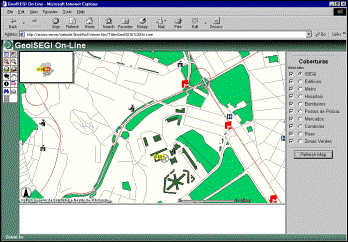
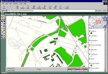
5.2 GeoISEGI:ISEGI-UNL location institutional website
The purpose of this study
is to provide a locational tool accessible through the ISEGI-UNL institutional
website. Two versions were developed: an HTML version and a Java based version.
| |
|
Figure 4 GeoISEGI (HTML version)
|
|
|
| |
|
Figure 5 GeoISEGI (Java version)
|
|
|
5.3 Accessibility study for emergency services
The purpose of this study
is to evaluate how is ISEGI located for emergency response (health care, fire
departments and police departments). Service areas were designed to know wich
areas were served by different services using different time intervals.
Shortest paths, using drivetime and distance, were calculated to know how to
get to the nearest service.
Authors:
Silva, P., Matos, P.,
Teixeira, E. and Rodrigues |
|
|
Figure 6 Website created for the accessibility study for emergency response
6. Conclusions
- It is a very efficient way of teaching GIS principles
and applications because student can actually see real WebGIS application
working on the Internet;
- Students are more motivated and committed if they can
share the results of their GIS projects on the Internet/Intranet;
- It is possible to mix internet software tools with GIS
software tools adding more value to student curricula;
- GIS job market has a great demand on this issue;
These reasons are more then enough to
include WebGIS both theoretical and practical components in GIS courses
curricula for Higher Education.
References
- Alves, H. (2001), GeoISEGI, project developed for the GIS course at ISEGI-UNL.
- Figueiredo, F., Botica S., Alves H. and Roseiro H. (2001), Comparaçăo entre duas classificaçőes de
utilizaçăo do solo para Campolide, project developed for the GIS course at
ISEGI-UNL.
- Foote, Kenneth E. and Anthony P. Kirvan. (1997) WebGIS, NCGIA Core Curriculum in GIScience,
www.ncgia.ucsb.edu/giscc/units/u133/u133.html, posted July 13, 1998.
- GeoWeb, www.geoweb.pt.
- Harder, C. (1998), Serving Maps on the Internet,
Geographic Information on the World Wide Web, Esri Press.
- Painho, Marco (1999). Sistemas de Informaçăo Geográfica - Provas de Agregaçăo, ISEGI-UNL.
- Silva, P., Matos, P.; Teixeira, E. e Rodrigues D. (2001), Estudo de accessibilidades
aos Serviços Públicos para o ISEGI, project developed for the GIS course at ISEGI-UNL.
- Where to Dispose of Britain's Radioactive Waste? Open Spatial Decision Making on the Internet,
www.ccg.leeds.ac.uk/mce/mce-init.htm.
- Xerox PARC Map Viewer, www.xerox.com/map.