A Case Study of the Blue River Watershed
Andrew N. Sauer, Water Resource Engineer, Camp Dresser & McKee, Inc., Kansas City, Missouri
Patrick. A. O’Neill, Water Resource Engineer, Camp Dresser & McKee Inc, Kansas City, Missouri
ABSTRACT
A stormwater master plan study was completed for the Blue River Watershed in southeast Johnson County, Kansas. The study focused on developing a stormwater management plan that addresses existing problems and provides guidance for future growth. Traditional US Army Corps of Engineers Hydrologic Engineering Center (HEC) models were applied with innovative mapping techniques using HEC-GeoRAS with ArcInfo and ArcView. These techniques allowed for the efficient development of spatially referenced watershed models covering 80 square miles. The GIS databases were efficiently used to develop input parameters for the HEC-1 and HEC-RAS models. ArcInfo coverages of land use, soil type, slope, elevation, and Manning’s n values were used to delineate 368 sub-basins and determine basin flow path, slope, and drainage area. Literature values were used in conjunction with GIS data, to develop values for key sub-basin input parameters such as sub-basin curve number and time of concentration. Both lag time and curve number for each sub-basin were calculated with a customized spreadsheet that used spatial data exported from ArcInfo. HEC-GeoRAS in conjunction with ArcInfo was used to prepare a geo-referenced based HEC-RAS model with stream network, cross-section geometry, and reach lengths. HEC-GeoRAS was used to generate HEC-RAS input data and process HEC-RAS output water profiles into spatially accurate watershed floodplains. Water surface profiles and cross-sections modeled in HEC-RAS were imported into ArcInfo using the HEC-GeoRAS software providing a cost-effective procedure to geographically link the model results to the GIS. Floodplain polygons were then overlaid onto existing GIS coverages in ArcView to provide an effective planning and decision making tool. In addition, ArcView scripts were effectively used to display, quarry, and export survey and cross-section profile data for use in HEC-RAS.
INTRODUCTION
Historically, watershed studies have used various sources of data such as paper map products (e.g. USGS 7.5° Topological Maps, County Soil Surveys, FIRM Maps, etc.), existing and future land use reports, database tables, and other county and city documents to model and delineate floodplains. These data sources were often difficult to use because they were produced at different scale and accuracy. Furthermore, the data was difficult to track with model input data almost impossible to reproduce after the study was complete. The final report typically contains a set of paper maps and volumes of hard copy model input and output data files that are difficult to use on a regular basis. For these reasons, watershed studies are rarely used as a long term planning tool that can be easily updated as development occurs in the watershed. To improve the efficiency, consistency, and usability of watershed studies, innovative methods were developed including:
À The use of continually expanding geographical information system (GIS) data sources,
À take full advantage of GIS tools,
À store and produce model input and output data in a GIS format, and
À effectively use graphical user interfaces.
Using GIS technology in the water resource-engineering arena is not a new concept. Several of the most popular computer models such as HEC-RAS, HEC-HMS, and Mike SWMM have GIS capabilities that are seldom used. According to Maidment and Djokic (2000), GIS technology has not been used more widely because:
À suitable data has been lacking,
À the technology was too expensive, and
À the engineering community lacked the training and education in GIS.
As more suitable data becomes available and the cost of computer hardware and software continues to fall, the final challenge to fully utilizing GIS technology with water resource studies is education and training. This paper attempts to address this issue by presenting a case study of the Blue River Watershed.
BACKGROUND
The Blue River Watershed Study (BRWS) is the first of seven watershed studies that will be completed for Johnson County, Kansas. One of the primary objectives of the BRWS was to develop a uniform set of GIS tools and procedures that could be applied to the hydrologic and hydraulic watershed modeling.
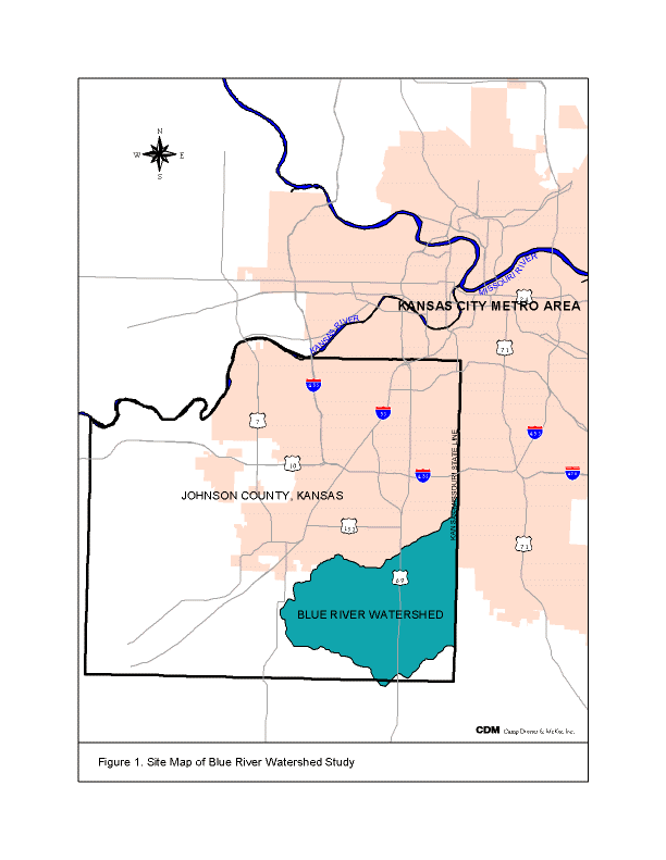
Johnson County, Kansas is a suburban community and is part of the Kansas City metropolitan area (Figure 1). Johnson County has experienced significant urban development in recent years and expects continual development. Due to this expected growth, Johnson County recognized the need for watershed studies to simulate current and future hydrologic and hydraulic characteristics, update FEMA FIS maps, identify flooding problems, develop improvements, and plan for future development. This and other watershed studies will provide the County with a consistent, comprehensive, and detailed analysis of the entire County.
The first step in the development of the watershed studies was to obtain detailed planemetrics coverage of the County. The detailed planemetrics combined with the Johnson County Automated Information Mapping System (AIMS) provided highly detailed watershed information that included:
À Continuous digital elevation model (DEM)
À Stream Centerline
À Hydrologic Features
À Roads
À Buildings
À Edge of Roads
À Driveways
À Property Boundaries
À Aerial Photographs.
AIMS is the County’s Geographic Information System (GIS). A GIS is a computerized system for managing large amounts of information that is geographically referenced, in other words, tied or related to a location. The County’s GIS provided the base for each watershed study. The goal of the BRWS was to efficiently use the GIS data to accurately simulate the watershed and then to provide the resulting data back in a GIS format that would add value to the County’s GIS database.
WATERSHED CHARACTERISTICS
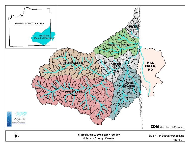
The Blue River Watershed is urban fringe watershed located in southeastern Johnson County, Kansas. The watershed is approximately 207 square kilometers (80 mi2) in size and is comprised of five major subwatersheds: Negro Creek, Coffee Creek, Wolf Creek, Camp Branch, and Blue River proper (Figure 2). The watershed is currently less than 25 percent developed with future develop expected. The land use in the watershed is primarily residential with some light industry and commercial business. The undeveloped area is composed of cultivated agricultural land, pasture, and wooded area. Future development is expected to be low to medium residential, recreation, light industry, and commercial.
HYDROLOGY
HEC-1 Model
The objective of the hydrologic model was to estimate the peak discharge, timing and volume of flows at various locations in the primary channel system using all available data including GIS data sources. HEC-1 was selected as the hydrologic model because of its wide use in the local engineering community. HEC-1, Version 4.1, is a US Army Corps of Engineers model (HEC, 1990) that was originally developed in October 1968. Although HEC-1 did not have direct GIS capabilities, a spreadsheet was used to properly format the data and integrate the model with GIS.
HEC-1 has a number of available methods for computing precipitation, runoff volume, runoff hydrograph generation, and flow routing. Table 1 lists the HEC-1 methods used in the Blue River Watershed Study and data required for each hydrologic process.
Table 1. Hydrologic Data Requirements
| Process | HEC-1 Method | Data Required |
Precipitation |
Hypothetical Storm | Local Rainfall Depth-Duration-Frequency Relationships |
Surface RunoffVolume |
SCS Curve Number | Basin Area Curve Number (Land cover, Soil type) |
| Runoff Hydrograph | SCS
Dimensionless Unit
Hydrograph |
Basin Lag Time
(Flow path length, slope and roughness) |
| Flow Routing | Modified Puls | Elevation
– Storage Curve Elevation – Outflow Curve Step Length Initial Conditions |
The physical and hydrologic parameters used to develop input for the HEC-1 model were derived from the best available geographic and technical information. The primary source of GIS data was the Johnson County AIMS Plannimetric 2000 data. Other GIS data such as land use, curve number, slope, and overland flow path was created in GIS as part of the project.
For the hydrologic analysis, the GIS data available included:
À Elevation Data (TIN and Contours)
À Soils Data
À Rain Gauge Locations
À Parcel Data
HEC-1 GIS Methods and Procedures
ArcInfo, ArcView, and the existing Johnson County GIS spatial data was used to develop the following information:
À Subarea boundary delineation
À Subarea drainage area
À Existing and Future Land Use
À Hydrologic Soil Type
À Curve Number
À Subarea flow path and slope
À Channel segment lengths and slopes
The initial characterization of the stream routing was developed based on the subarea boundaries and the stream network required to drain each subarea. Literature values and best professional judgment were used, in conjunction with GIS data, to develop subarea input parameters, such as Manning n values for overland and shallow concentrated flow, and curve numbers for various land uses and soil types. The GIS methods used to develop the various basin parameters are discussed below.
The 207 square kilometer watershed was first divided into five major subwatersheds: Negro Creek, Camp Branch, Coffee Creek, Wolf Creek, and Blue River. An ArcInfo coverage was developed and used to define the study area boundary.
Each subwatershed was delineated into subareas with upstream areas of approximately 65 hectare (160 acres). The subarea delineation was performed using the ArcInfo Grid module. A total of 368 subareas were developed with an average size of 54-hectare (133 acres). Appropriate subarea outlets were identified in ArcView as stream crossings, tributaries, and major lakes/ponds. The subarea outlet point coverage and the DEM were required to automatically generate the subarea boundaries in the GIS.
After the subarea boundaries were delineated using ArcInfo, the subarea drainage areas were automatically calculated in ArcInfo for each subarea polygon. The subarea name and drainage area was then exported as a database table and input into the customized spreadsheet developed for the project to generate the HEC-1 input file.
Using GIS, a composite curve number was developed for each subarea based on land use and hydrologic soil type. A composite curve number was calculated for both existing and future land uses with a customized spreadsheet. The customized spreadsheet used the subarea percent soil types and land uses to calculate a composite curve number and then format the data for HEC-1.
Existing and future land use was compiled from a variety of sources in an effort to produce a complete, consistent GIS land use coverage. The base data consisted of the Johnson County and city parcel data. For existing conditions, land use codes were developed based on tax records and land use documentation. Because the land use classes were not consistent between the cities and the County, the Kansas City Metropolitan Chapter of the American Public Works Association (1990) Section 5600 land use classifications were used as the basis for classifying land uses within the watershed. The APWA classification categories were then modified slightly to best match the land use of the watershed.
The future land use condition was developed to simulate an ultimate build-out scenario. The future land use was based on future land use maps prepared by Johnson County and cities within the watershed and a surrogate land use condition. The surrogate land use was required because future land use maps had not been completed for the entire watershed. The surrogate land use was developed by calculating the percent land use of a surrogate developed area and then applying that land use to the unknown developed future land use area.
The hydrologic soil groups were determined from the County GIS soil coverage. The County soil coverage provided the soil name and classification. Hydrologic soil groups (A, B, C, or D) were applied to each soil type based on the County Soil Survey. For each subarea, a percent area of each hydrologic soil type was calculated using ArcInfo. The percent hydrologic soil type for each subarea was then exported to the customized spreadsheet to calculate a composite curve number.
A lag time for each subarea was calculated using a methodology consistent with the TR-55 (Soil Conservation Service; 1986). The lag time for a subarea was assumed to equal 0.6 times the time of concentration. The time of concentration was divided among four overland flow elements:
À Sheet flow
À Shallow concentrated flow
À Secondary channel flow
À Primary channel flow
In each subarea, the longest overland flow path to the subarea outlet was defined in ArcInfo using GRID. The flow path was then divided into the four overland flow path elements listed above. ArcInfo was used to calculate the length and slope of each flow element. The slope of each segment was calculated using the DEM and ArcInfo GRID.
Sheet flow was assumed to occur at the furthest upstream portion of the flow path. The sheet flow length was estimated in ArcInfo by assuming that sheet flow occurs along the subarea flow path up to the point at which the drainage area to the flow path exceeds 1/20 hectare (1/8 acre). This value was selected based on the sensitivity of the sheet flow length to several different drainage area values. For the Blue River Watershed, the average sheet flow distance was 53 meters (173 feet) with a maximum of 91 meters (300 feet) and a minimum of 8 meters (25 feet). The overland sheet flow Manning n value for each subarea was determined by overlaying the existing and future land use with the overland flow path coverage.
Shallow concentrated flow occurred between the sheet flow segment and the start of open channel flow. Open channel flow was assumed to begin at a point where intermittent or perennial streams (blue lines) are denoted on U.S. Geological Survey (USGS) 7.5 minute quadrangle maps. The USGS maps of the Blue River Watershed were reviewed to estimate the drainage area at which intermittent or perennial streams begin. The results indicated that, on average, intermittent or perennial streams were typically shown for drainage areas of approximately 8.1 hectare (20 acres). An assumption was made, therefore, that shallow concentrated flow in a subarea occurs at drainage areas of 1/20 hectare to 8.1 hectare (1/8 acre to 20 acres) along the subarea flow path.
Secondary channel flow and primary channel flow occur between the end of shallow concentrated flow and the subarea outlet. Secondary channel flow was assumed to occur between the end of shallow concentrated flow and the flow path intersection with the primary stream network; primary channel flow occurs along the primary stream network to the subarea outlet. The primary stream network was the main channel of the river system and tributaries that receive runoff from areas approximately 65 hectare (160 acres) in size and greater. The hydraulic performance of this network was evaluated with the HEC-RAS model. Depending upon location, a subarea may have one or both of these channel flow features. For example, a headwater subarea will probably not contain a channel segment associated with the primary stream network.
The travel time for each of the four flow path types was calculated according to the TR-55 methodology from physical data derived from the GIS.
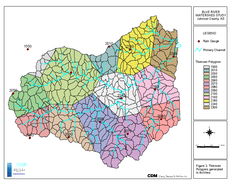
For historical storms, rain data from all available gauges within or near the watershed were used to develop the precipitation data for he HEC-1 model. The rain data was distributed across the watershed using the Thiessen polygon method and an ArcView public domain script. The Thiessen polygons were developed from available rain gauge locations for each event as shown in Figure 3. Based on the polygons, the appropriate rain gauge was then automatically assigned in ArcView to each subarea by overlaying the Thiessen polygons onto the subarea polygons.
For the BRWS, subarea hydrographs were combined and routed throughout the primary stream network by the Modified Puls routing method. This approach takes advantage of the overlap between the hydrologic and hydraulic models so that the hydrologic model routing can account for the effect of channel and floodplain storage in the primary stream network. A customized spreadsheet was developed to loosely join the two models. The spreadsheet provided the framework to efficiently perform the required iterations between hydrologic and hydraulic models. The use of a customized spreadsheet greatly reduced the time required to link the hydrology with the hydraulic models and to import GIS data.
HYDRAULICS
The objective of the hydraulic model was to develop accurate floodplain maps based on flows from the hydrologic model using all available data including GIS data sources. The USACE HEC-RAS, Version 2.2 was used for the BRWS. The HEC-RAS model is a popular hydraulic software used in countless hydraulic studies and was well accepted by the local engineering community. Another important feature of HEC-RAS, Version 2.2 was that it had the capability to import and export data in a GIS format.
As a tool to link HEC-RAS with GIS, the USACE developed HEC-GeoRAS, which is a set of Arc Macro Language (AML) programs specifically written to extract HEC-RAS geometry data from ArcInfo for input in HEC-RAS and then delineate floodplain boundaries from HEC-RAS output. For the BRWS, HEC-GeoRAS with ArcInfo was used to create the base HEC-RAS model and produce geo-referenced floodplain maps. The stream network, cross-section geometry, flow lengths, and resulting floodplain maps were generated with HEC-GeoRAS. HEC-GeoRAS is a public domain software program developed by the Hydrologic Engineering Center (HEC). HEC-GeoRAS runs in conjunction with ArcInfo to prepare an ASCII text file that is directly imported by HEC-RAS.
The hydraulic characteristics of drainage structures, bridge crossings, and open channel cross-sections were developed with HEC-GeoRAS, field survey data, and traditional modeling techniques. The HEC-RAS model was geo-referenced to the Kansas State Plane Coordinate System. Table 2 summarizes the hydraulic detail that was incorporated into the BRWS HEC-RAS model.
Table 2. Summary of Blue River HEC-RAS Model
Number of Basins Modeled |
5 |
Number of Reaches Modeled |
130 |
Total Distance of Stream Network Modeled |
182 km (113 mi) |
Length of Main Channel |
68.4 km (42.5 mi) |
Length of Tributary Channel |
113.5 km (70.5 mi) |
Total Number of Junctions Modeled |
64 |
Total Number of Cross-Sections |
1309 |
Average Cross-Section Spacing |
140 m (460 ft) |
Total Number of Hydraulic Structures Modeled |
164 |
Number of Bridges Modeled |
31 |
Number of Culverts Modeled |
90 |
Number of Dams (Inline Weirs) Modeled |
43 |
To develop the HEC-RAS model, GIS technology was used to efficiently generate a detailed hydraulic model. ArcInfo with HEC-GeoRAS, ArcView, and other customized scripts were used to generate input and output data as discussed below.
The input parameters for the HEC-RAS model were developed using four data source tools/resources:
À ArcInfo GIS. ArcInfo was used along with existing Johnson County GIS coverages and GIS data developed specifically for this project, to generate four of the HEC-RAS input parameters:
¿ Primary stream network
¿ Cross-section geometry
¿ Flow lengths (channel and overbanks)
¿ Overbank Manning n values
À HEC-GeoRAS. HEC-GeoRAS, in conjunction with ArcInfo, was used to create the base HEC-RAS model. The stream network, cross-section geometry, and flow lengths were generated with HEC-GeoRAS. Five ArcInfo coverages were required by HEC-GeoRAS to prepare the ASCII text file:
¿ Triangulated irregular network (TIN)
¿ Contours
¿ Primary Stream network
¿ Cross-section cut-line coverage
¿ Overbank flow path coverage
À Field Survey. Field surveys were obtained for roadway crossings, dams, and select locations on the modeled stream network. Field data were collected based on monumented and global positioning system (GPS) controls using standard field survey collection forms. The field survey points were converted into a GIS point theme with elevation, point ID, and structure ID as attributes. This survey point theme was then overlaid onto existing GIS coverages to verify the survey accuracy. The structure survey data were manually input into the base HEC-RAS model that was created using HEC-GeoRAS.
À Other Data Sources. A more traditional approach was used where the approaches to preparing model data and /or parameters described above could not be applied. The development of many model parameters, such channel Manning n values, expansion and contraction coefficients, boundary conditions, and ineffective flow areas relied on the use of textbook values, model user’s manuals, other master planning studies and engineering judgement.
The eleven input parameters required for the HEC-RAS model are summarized in Table 3 along with the data development methods for the BRWS. The GIS data development methods are described in more detail later in the paper.
Table 3. HEC-RAS Data Development |
||
Model Parameter |
Data Development Method |
Requirements |
Primary stream network |
ArcInfo and HEC-GeoRAS |
Stream network coverage with stream reach Ids |
Cross-sections |
ArcInfo and HEC-GeoRAS |
TIN, cross-section cut-line coverage |
Flow lengths |
ArcInfo and HEC-GeoRAS |
Channel and overbank (left and right) flow path coverage |
Overbank Manning n values |
ArcInfo and ArcView |
Land surface coverage created from orthophotos and verified with ground truthing |
Roadway crossings |
Field survey and ArcView |
Roadway profile and bridge or culvert opening |
Dams |
Field survey and ArcView |
Control structure dimensions and embankment profile |
Channel n values |
Manually |
Primary Stream Network and Stream Order |
Expansion and Contraction Coefficients |
Manually |
Contour and cross-section coverages |
Boundary conditions |
Manually |
Downstream FEMA study |
Ineffective flow areas |
Manually |
Contour and cross-section coverages |
Channel bank stations |
Manually |
Cross-section coverages |
The stream network, comprised of the main channel of the basin and the tributaries that receive runoff from areas approximately 65 hectare (160 acres) in size and greater, defined the extent of the model (Figure 2). For the Blue River watershed, 182 kilometers (113 miles) of stream network were modeled in HEC-RAS. The primary stream network was divided into 130 reaches between the five subwatersheds.
The primary stream network was created using ArcInfo and HEC-GeoRAS, which produced a geographically correct HEC-RAS stream network. Each vertex in the stream network contained the correct x-y state plane coordinate. The GIS stream centerline coverage was created using the existing Johnson County hydrography GIS coverage. HEC-RAS required that each reach be defined as only one arc and both ArcInfo and HEC-RAS required that each arc contain 500 or less vertices. Reaches with more than 500 vertices were generalized in ArcInfo to meet the required format. The primary stream network coverage was used in HEC-GeoRAS to create the stream network for the HEC-RAS model.
Cross-sections were developed for the primary conveyance system to accurately simulate the hydraulic characteristics and to delineate the floodplains. For the BRWS HEC-RAS model, 1,309 cross-sections were used to model the watershed hydraulics. The cross-sections were located where specific hydraulic and hydrologic data were needed. For example, cross-sections were located at a location that was a representative channel reach section, and where there were significant changes in hydraulic and/or hydrologic characteristics over short distances, such as changes in geometry, slope, roughness, or discharge.
Cross-sections were developed in ArcView by using using “heads-up” digitizing with the elevation contours and aerial photographs as a base map. Cross-sections were digitized starting from the left overbank looking downstream to the right overbank as specified by HEC-GeoRAS. The cross-sections were configured perpendicular to flow in the channel and floodplain. This procedure resulted in geographically correct cross-section lines that were an accurate reflection of the area.
The following cross-section parameters were determined to accurately perform the hydraulic analysis:
À Cross-section connectivity (the location of each cross-section in relation to others in the model and the stream network)
À Cross-section geometry as station-elevation pairs
À Channel and overbank flow lengths for the cross-section reach
À Overbank Manning n values
ArcInfo, in conjunction with HEC-GeoRAS, was used to develop the cross-section connectivity, geometry, and flow lengths. HEC-GeoRAS creates a file from GIS coverages that was directly imported into the HEC-RAS model that contains the cross-section connectivity, geometry, and flow lengths. The following three coverages were developed:
1. GIS stream centerline network from the County’s hydrographic coverage to calculate the cross-section connectivity.
2. Triangulated irregular network (TIN) from the existing County GIS elevation data to create the cross-section geometry.
3. Overbank flow line coverage, in conjunction with the stream centerline coverage created in Step 1, to calculate flow lengths.
The flow length is the average distance the water travels between cross-sections. Three flow lengths were inputted into the model: channel centerline, left overbank, and right overbank. ArcInfo and HEC-GeoRAS were used to develop the flow lengths. The primary stream network coverage was used to calculate the channel flow length. An overbank flow coverage was created to determine overbank flow lengths for both the left and right overbanks. Lines were created in the overbank flow coverage to represent the average left and right overbank flow paths between each cross-section. The FEMA 500-year floodplain boundary and the contour information were used as a guide to locate the overbank flow paths. HEC-GeoRAS used the primary stream network coverage and the overbank flow coverage to calculate the HEC-RAS flow length input data.
The overbank n values were generated with ArcView and digital aerial photographs. A GIS coverage of the left and right overbank land cover was created in ArcView by using “heads-up” digitizing of digital aerial photographs. The associated overbank Manning n values were determined with GIS by assigning an overland Manning n value to each land cover. The horizontal extent of each type of land cover and the associated n value for each cross-section was determined by intersecting the land cover polygons with the cross-section cut-line coverage. ArcInfo AML programs were used to create the cross-section Manning n values and format the data for input into HEC-RAS. The n values were input into the HEC-RAS model with a text editor. Multiple n values across the cross-section were used as necessary to accurately describe changes in land cover across the cross-section.
Bridge and culvert openings, roadway profiles, and dams were developed from field survey data and County planemetrics. Field survey crews collected cross-section profiles, GPS points, completed structure inventory sheets, and obtained photographs of each hydraulic structure. The hydraulic structure survey points were used to create a point coverage in ArcView. The survey point coverage was used to extract supplemental data in ArcView such as distance to upstream cross-section and decking width. Other GIS coverage used in ArcView such as contours, roads, and aerial photographs near each structure were found to be invaluable.
Other GIS Tools
After the initial HEC-RAS model was developed with HEC-GeoRAS, it was necessary to add new cross-sections or test different cross-section orientation and spacing without regenerating a complete HEC-GeoRAS file. The cross-sections were added by cutting new cross-sections from the contours in ArcView and exporting them to the HEC-RAS model. This was done using one of two methods: 1) manually determining stationing and elevation data from the contours in ArcView and 2) using the TDMS-Profiler script developed by 4DM for ArcView. Both methods require manual input of the station and elevation data. The TDMS-Profiler automates the process of cutting the cross-section by providing the stationing and elevation data for each cross-section. Both methods require that the channel and overbank lengths be manually updated along with the vertex coordinates to orient the cross-section. The TDMS-Profiler script is currently being updated to further automate the generation of cross-sections from elevation contours in ArcView.
FLOODPLAIN MAPPING
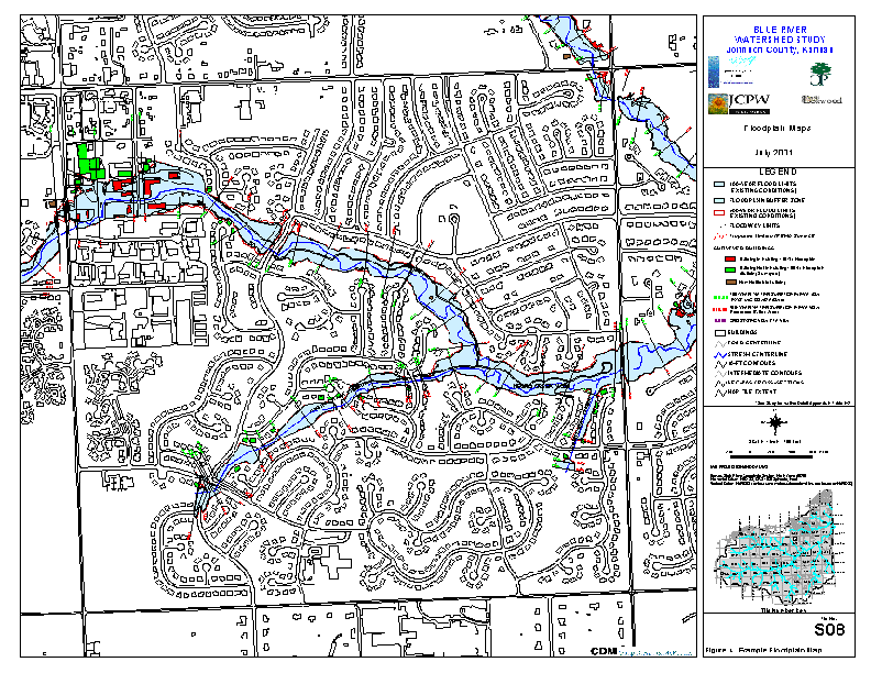
Floodplain
boundaries were generated automatically with HEC-GeoRAS and ArcInfo. Water
surface profile data and cross-section data from HEC-RAS was exported as a GIS file. In ArcInfo,
HEC-GeoRAS used the exported GIS file and the elevation TIN to generate water surface
polygons. The spatially referenced floodplain
boundaries resulted in a highly accurate and geo-referenced coverage that could be used
with other GIS watershed data (Figure 4). The resulting floodplain delineation polygons
were then used to identify buildings in floodplain, locate street flooding, and to provide
an effective planning tool. The final
existing and future floodplain boundary will become part of the County GIS database.
SUMMARY
The Blue River Watershed Study used GIS data with traditional hydrologic and hydraulic computer models to generate a detailed spatially referenced floodplain study. The floodplain study was used as a template for future Johnson County studies. Methodologies and procedures developed for the Blue River Watershed Study incorporated innovative GIS techniques to develop detailed hydrologic and hydraulic computer models.
Hydrologic and hydraulic simulations were performed for both existing and future condition using the Army Corps of Engineers HEC-1 and HEC-RAS computer models. HEC-1 and HEC-RAS were linked by calculating channel storage volume in HEC-RAS for input into HEC-1 as storage routing (Modified Puls). A customized spreadsheet was developed to link the two models and to automate the data entry.
ArcInfo and ArcView were vital in the success of the project. HEC-GeoRAS, customized AMLs, and ArcView scripts were also used to extract data from the GIS. Model input and output data was generated in a spatial format, which provided uniformity and consistency of model parameters. The final floodplain boundaries were produced in a geo-referenced format that could then be added to the County’s GIS database.
ACKNOWLEDGMENTS
The authors would like to acknowledge Johnson County, Kansas, the Cities of Overland Park, Leawood, and Olathe, Kansas, and the University of Kansas for their contribution and support of this watershed study. We would like to specially acknowledge Kent Lage, Project Manager for Johnson County, Bill Heatherman, City of Overland Park, and Dr. David Parr, University of Kansas for their contributions to this successful project.
REFERENCES
Barnes, H. H. 1967. Roughness Characteristics of Natural Channels. U.S. Geological Survey Water-Supply Paper 1849. United States Government Printing Office. Washington D.C.
Chow, V. T., D. R. Maidment, and L. W. Mays.1988. Applied Hydrology. McGraw-Hill, Inc. New York, NY.
Chow, V. T. 1959. Open-Channel Hydraulics. McGraw-Hill, Inc. New York, NY.
Hydrologic Engineering Center. 1999. HEC-GeoRAS, An application for support of HEC-RAS using ARC/INFO: User’s Manual, Version 1.0. US Army Corps of Engineers.
Hydrologic Engineering Center. 1998. HEC-RAS, River Analysis System: Hydraulic Reference Manual, Version 2.2. US Army Corps of Engineers.
Hydrologic Engineering Center. 1990. HEC-1 Flood Hydrograph Package User’ Manual. US Army Corps of Engineers.
Kansas City Metropolitan Chapter of the American Public Works Association. 1990. Section 5600, Storm Drainage Systems and Facilities.
Maidment, D. and D. Djokic (ed.). 2000. Hydrologic and Hydraulic Modeling Support with Geographic Information Systems. Environmental Systems Research Institute, Inc., Redlands California.
Soil Conservation Service. 1986. Urban Hydrology for Small Watersheds. Technical Release 55. United States Department of Agriculture.
Soil Conservation Service. 1975. Urban Hydrology for Small Watersheds. Technical Release 55. United States Department of Agriculture.