Title: Building a Rural Geographic Information Systems (GIS) Through Cooperative Joint Projects
Author: Alan Frank - GIS Administrator Albany County/City of Rawlins, Carbon County, Wyoming
Michael Knapp - Deputy Assessor/GIS Coordinator Albany County, Wyoming
Organization: Albany County, Wyoming
Abstract
Albany County, located in southeastern Wyoming, comprises 4,400 square miles and contains small predominately agriculture and student based population of 30,000 in a state that has a population of 450,000. Twenty-five percent of said land is public property and therefore tax exempt. Thus, this results in the importance of utilizing limited resources and is paramount in the success of developing a GIS. This presentation will focus on utilization of these resources, cost sharing between local governmental agencies, and a review of data sets created. Explanations of how city and county functions and tasks can be utilized by both entities in a win/win GIS arrangement benefiting all parties will be discussed.
Introduction
In an effort to maximize limited hardware, software and personnel resources, joint cooperative programs are becoming imperative to the success of GIS in rural communities. Joint programs allow for maximum returns on limited budgets and resources, while providing the most cost-effective manner to assist the public. This project is among two different government entities from two different counties. How does this work?
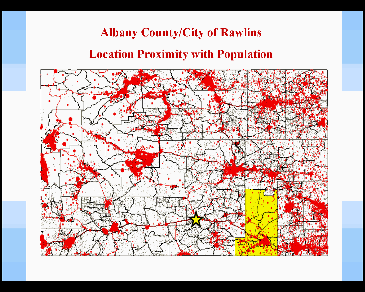
Location of Albany County in Relationship to City of Rawlins, Carbon County, Wyoming, this also shows population density in Wyoming.
Background
Albany County is located in southeastern Wyoming it comprises 4,400 square miles (approximately 2,816 million acres) and contains 146 townships and ranges. Twenty-five percent (700 million acres) of these parcels are tax exempt due to forest service land, Bureau of Land Management and University of Wyoming and approximately 1,600 miles of roads, half of which are maintained by the county.
City of Rawlins, Carbon County, Wyoming is located 100 miles northwesterly from Laramie along the I-80 corridor. It has a population of 9,000 people with a city area of 5,120 acres (9 square miles) and contains 4,000 parcels. It differs from the county operation in that it also has to deal with its’ municipal infrastructure.
Mapping Background
Albany County seriously started it’s mapping program in 1989, after a state directive was passed ruling that Assessor’s offices throughout the state would create and maintain the parcel ownership mapping, a major part of property valuation "location, location, location". At this time it was decided to begin keeping and maintaining maps in an AutoCAD environment. This also made it easier to update existing Mylar maps. A base map, purchased in 1993 included USGS base map information containing only township and range, and also separate layers for hydrography and road center lines.
In 1998, Albany County began working on a GIS pilot project working with the maps and a newly developed Microsoft Access database being used by the county assessor’s office. Integrating the database with the maps meant that we had to upgrade software to Esri ArcView, along with starting to think about ArcInfo for the software’s editing capabilities. At this point the assessor’s office decided to change base maps. The Geographic Coordinate Data Base (GCDB) developed by the Bureau of Land Management, Wyoming State Office, became available for county use. This data had some problems however, so Premier Data Services, Denver, Colorado was hired to clean up the duplicate nodes and line work as well as finish townships that had not been yet been completed. This new base map included township and range grids, sections broken down to the 1/16 th pt and government survey lot grids, derived from the original Government Land Office survey notes. We also contracted with Premier Data Services to automate the mapping process for the Albany County aliquot sections, using their product Carte’ View. By using the existing Long Legal Data from the assessor’s office, the program was able to create 11,000 parcels of the 16,000 parcels that are included in Albany County. This proved to be an economical way to build large parcels in a short amount of time.
With the majority of the mapping in place, how do we finish as well as keep the maps updated with a staff of one - Mike Knapp. It is not possible for one person to map parcels, maintain, supervise mapping and keep up with Deputy Assessor responsibilities. A major problem encountered was a limited payroll budget and with expertise required that a beginner’s experience could not provide. Although we can pull from the University of Wyoming in Laramie, there is still a learning curve for this position. We previously contracted with Alan Frank, employed by a local engineering firm, on county database problems Alan also had extensive GIS experience, was he interested in employment with a government entity?
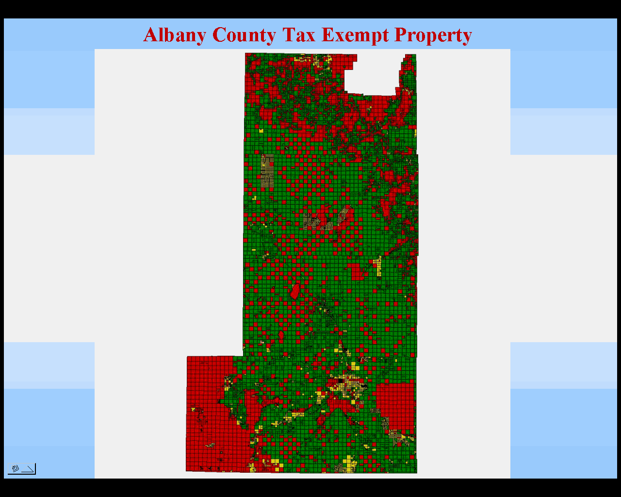
Albany County showing Parcels and tax exempt parcels.
Rawlins
The City of Rawlins, Wyoming started its mapping program in 1985. Their first step to start the mapping process was to have the city flown, stereo compiled and delivery of the data was in AutoCAD exchange files. However the City for years was unable to use this information since they lacked operators to work the data.
In 1998, the city came to the realization that a GIS system was needed to assist in daily functions of city government. With this thought in mind, they proceeded with sub-contracted services with Alan to convert existing aerial data into usable GIS. Thus GIS was born in the City of Rawlins.
In recent years this program has been able to build over 50 layers of information including updated planimetric, cadastral, utility, planning, and emergency services.
Albany County regarding a joint venture in GIS approached the City of Rawlins. Since Albany County could not afford to hire some one with Alan’s experience, would Rawlins like to share and employee. This agreement was monumental in the fact that they would be able to save money while gaining GIS experienced staff. The other factor, which made this program so unique, was that both participants were from different counties but required similar GIS knowledge.
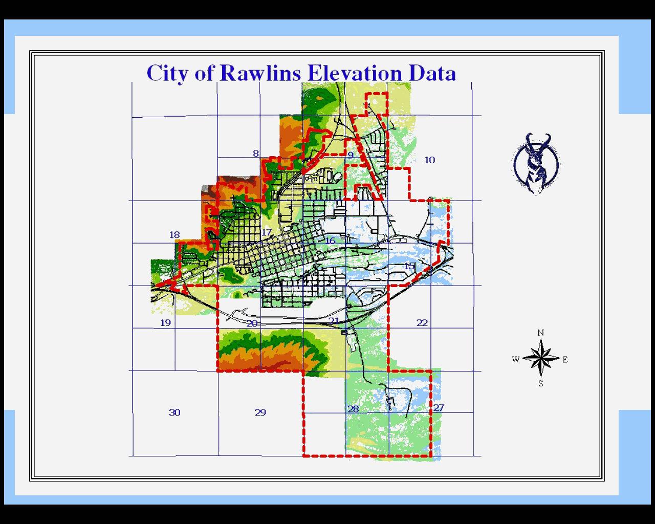
Overview of the City of Rawlins, Carbon County, Wyoming showing planimetric data and elevation contours.
Joint GIS Created
In July of 1999 a joint GIS program was begun between the two entities. With this program came many positives. Albany County brought to the table Auto Cad and Arc View experience, as well as Cadastral Mapping expertise. Albany County also brought with it an Esri livable Communities Grant, which included the ArcInfo software and several great extensions. Albany County also helped to provide Cogo data entry assistance, with AutoCad, city cadastral mapping expertise and county database management skills
The City of Rawlins brought to the table ArcInfo and ArcView background and planimetric mapping experience. It had also received an Esri Public Safety Livable Communities Grant. The addition of this grant provided both entities with ArcView and all of the various extensions that came with the Grant. Rawlins also brought with it engineering expertise, emergency services/E 911 knowledge and satellite Imagery/aerial photographic expertise.
The two entities agreed to hire Alan Frank to administer both systems. The agreement was that the county would provide 70 percent of wages and the City of Rawlins would provide 30 percent. The work would be split between the two entities in proportionate shares. Alan’s main office would be in Laramie and he would commute to Rawlins as needed. Most of the work being completed via Internet and the US mail service. His experience in the private sector also provided needed expertise to administer two systems and provide consultation on many aspects of both projects.
Satellite Imagery
One thing that Albany County was missing in its GIS system was current Imagery throughout the county. What we had in house was hard copy Color IR Orthoquad 1:24000 series from a 1984 flight completed by the State of WY. The newest available orthoquads are from a 1994 flight completed by the BLM, and Albany County was not complete. Our portion of trying to get this task complete would have been $100,000. It was a large sum for a county with limited resources. The GIS yearly budget is $10,000. To top this, the data was already 7 years old, and most of the county growth has taken place since 1994, so it wouldn’t help for what was needed. We started looking at Space Imaging for satellite imagery. We were able to have the county complete for around $30,000 - still not within budget. Imagery that was being considered for county coverage available from Space Imaging included 5-meter IRS quad imagery throughout the county and one-meter IKONOS imagery in the more populated areas. With this in mind, we began looking for investors who might be able to help fund the imagery project. Those most interested were the Albany County Sheriffs Office, City of Laramie/Albany County Records and Communication Center and the City of Laramie public works department. The trade off is that we would provide GIS data and consultation as needed. In effect the result is a cooperative within a cooperative.
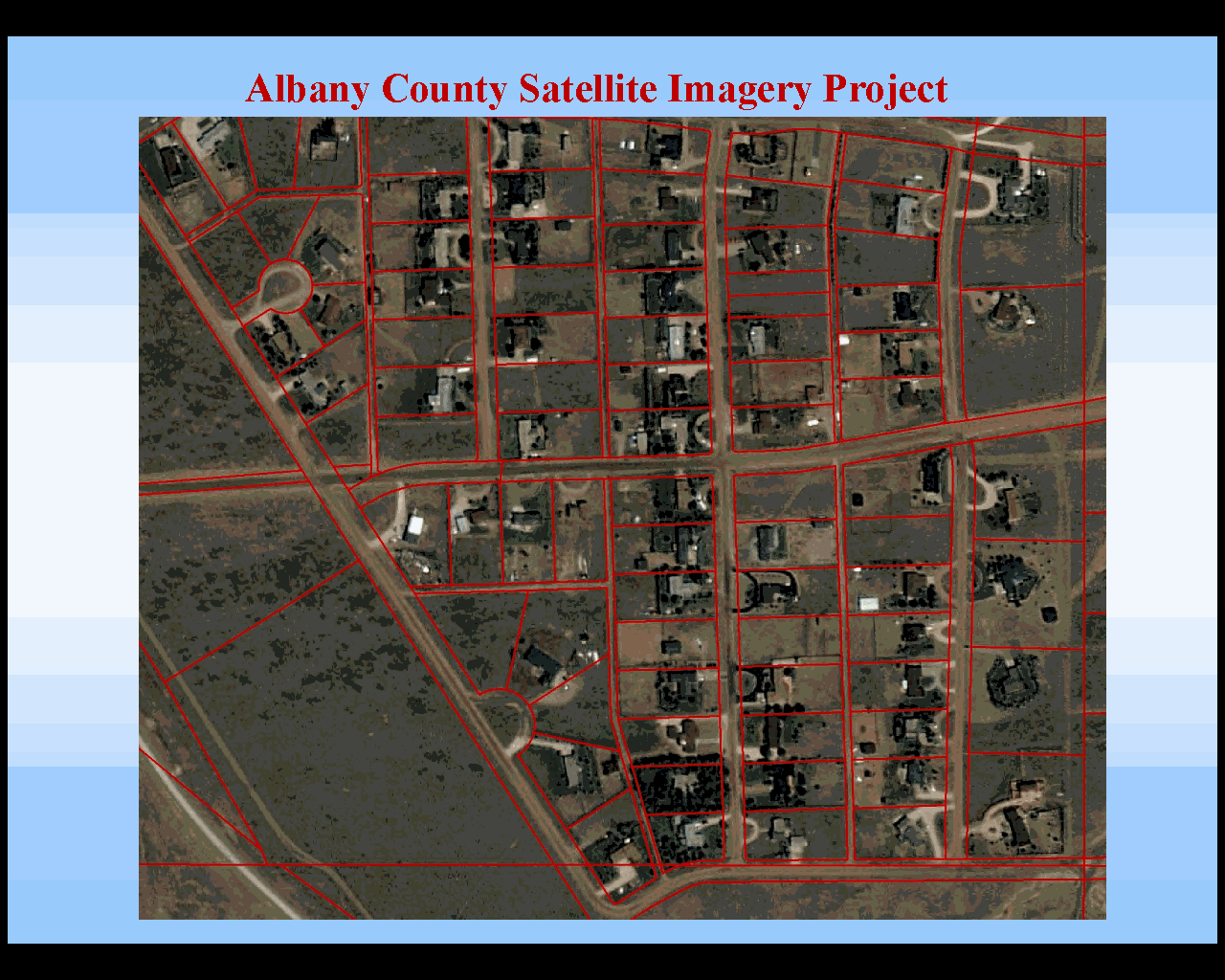
One-meter IKONOS satellite imagery from Space Imagery showing plat lines of Sherman Hills subdivision with the imagery as a background
Conclusions and Benefits of a Joint GIS
We learned many valuable lessons within the joint cooperative agreement. One is that both parties did not have to out-source projects. Expertise that we shared was affordable and cost effective for projects that then become easier to budget for. Staffing costs were also reduced due to sharing. Both entities did not have to have separate staff to do duplicate efforts. This also brought about a larger pool of expertise to answer difficult questions. This project would not have been as successful without experienced team members.
Hardware/software costs were lower; both entities were not required to duplicate these costs. With Grants provided by Esri, it made it more affordable for two small entities to begin developing a GIS program. GIS projects for both entities could use the same machines and software, and by housing those in one location these costs did not need to be duplicated. Since the team already was made up of an experience ArcInfo user, there was no need for expensive training. Alan could also provide training for less experienced users.
Programming used by either entity did not have to be re-written so less time was spent, we did not have to "reinvent the wheel" for each project. Databases were similar enough that downloads of new data from the State of Wyoming computer mainframe to the local system were similar and did not require extra steps in processing. Mistakes and problems that were encountered from either of the entities could be used as a learning experience, rather than a downfall.
Expanded joint staff knowledge became an asset in particularly difficult areas, such as addressing. The City did not understand what data the County had or how to use it and vice versa. What occurred helped to open up a new line of communication between local government entities, even if the other entities were not directly involved. It really became a win/win situation for all involved. Through this joint partnership Albany County and The City of Rawlins were awarded The Wyoming Association of Municipalities Innovation award for 2001, as well as having the pleasure of being published in Imaging Notes, May/June 2001 issue.
We are not complete with our project and still have much to do. With the short time that we have been working on our joint project we have seen much growth, and have opened eyes in other areas of the State of Wyoming on what you can do with GIS and working together.