Author: Andrew G Abouna Organization: City of San Diego
As downtown San Diego continues its rapid transition into a cosmopolitan "24-hour city," everything from high-rise office towers to small one-and-two-story dwellings are becoming wired to welcome these "sunrise industries." The website www.bandwidthbay.org has been designed to provide the necessary resources for a person or company (large or small) who is considering relocating to this burgeoning hi-technology region to make a better informed decision. Bandwidth, defined as the carrying capacity of the copper wire or fiber optic cable that connects an office or home to the global Internet, determines the amount of data and speed at which files and video move from different points on a network.
Www.bandwidthbay.org illustrates why downtown San Diego is the perfect location for high-technology companies. The site offers a listing of current companies operating in downtown, a listing of wired buildings able to accommodate technological demands, a database of area service providers, related news and notes regarding technology, a link to the training resources available in downtown, and soon a GIS map to view where fiber optics are located throughout the Centre City. It's a powerful and helpful service to those businesses considering a relocation.
The City of San Diego has converted the downtown's end-user fiber optic network database into an interactive Geographic Information System (GIS) color-coded format which allows the data to be viewed across the Internet. This Bandwidth Bay Fiber Network Map shows the providers who are servicing a particular street or building. Using a variety of query tools a particular fiber optic provider can be located and various types of information about the streets or buildings can be viewed.
Some 10 layers of information can be viewed and queried with the Bandwidth Bay Fiber Network Map, including the fiber optic network, "wired" buildings, service provider homepages, freeways, local roads, property boundaries, parks, Centre City Development Corporation areas, aerial orthophoto, and street addresses.
For those providers whose network is mapped the information is believed to be current through 1999.
The information presented in this application is currently only for the Downtown area and is best viewed with Microsoft
Internet Explorer. Press the link below to launch the mapping application, and be sure to use the help tool for more
information on querying, viewing and printing the information:
In this tour you will learn about:
TIP: You may want to print this document using your browser's ![]() print button, then go back
to the application to see the various icons and graphics more clearly, and step through the tour
on your own. Also, resize your browser if the graphics and text overlap.
print button, then go back
to the application to see the various icons and graphics more clearly, and step through the tour
on your own. Also, resize your browser if the graphics and text overlap.
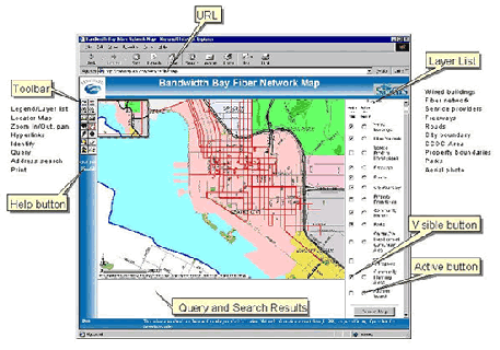
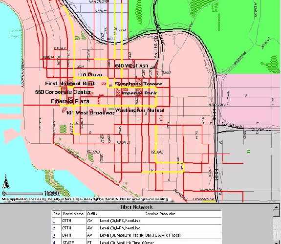
When the Fiber Map application first loads you will see the following overview map of the
downtown area. The shading on the map shows the various City of San Diego Community
Planning Areas with the roads and fiber network on top.
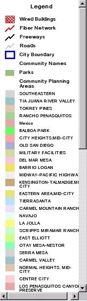
Change the layer list to the legend using the![]() tool
tool
The application is arranged with the title on the top, text results from queries
on the bottom, on the left side is the toolbar for navigating and querying the
information layers, and on the right side is a list of the available information layers.
TOOLS
The tools on the left side toolbar allow for map navigation and information query. Place the mouse over the tool to reveal its function. With the tools you can:
![]() change the layer list to the legend
change the layer list to the legend
![]() show the locator map
show the locator map
![]() zoom in
zoom in
![]() zoom out
zoom out
![]() pan
pan
![]() zoom to the 'active' layer
zoom to the 'active' layer
![]() zoom to the full extent of the largest layer
zoom to the full extent of the largest layer
![]() return to a previous geographic extent
return to a previous geographic extent
![]() access hyperlinks of an active layer
access hyperlinks of an active layer
![]() identify active layer attributes
identify active layer attributes
![]() choose a query
choose a query
![]() clear a search
clear a search
![]() locate an address
locate an address
![]() print a map
print a map
TIP: Use the ![]() button to view additional hints for navigating and querying the
application.
button to view additional hints for navigating and querying the
application.
LAYERS
There are 12 layers of information that can be viewed and queried for Downtown San Diego:
| Information Layer | Viewable Information |
| 1. Wired Buildings | Building name, address, building manager (name, phone number, URL/website), service providers, rentable square feet, vacancy rate |
| 2. Wired Building Names | Building name |
| 3. Fiber Network | Service provider(s), street name |
| 4. Service Providers | URL/website to downtown service providers |
| 5. Freeways | Freeway names |
| 6. Roads | Road names |
| 7. City Boundary Municipal | Boundary of the City of San Diego |
| 8. Community Planning Areas | City of San Diego Community Planning Area names |
| 9. Centre City Development Corporation (CCDC) | CCDC Planning areas |
| 10. Property Boundary | Assessor Parcel Number |
| 11. Parks | no attributes |
| 12. Aerial Orthophoto | no attributes |
To make a layer visible click the 'visible' ![]() button next to layer's name, then redraw a new map
by choosing the
button next to layer's name, then redraw a new map
by choosing the ![]() button below the layer list.
button below the layer list.
TIP: To improve map clarity some of the layers are unavailable for viewing until you zoom into
the map.
SELECTING INFORMATION
To select or query information from a layer it must be 'active'. Choose the 'active' ![]() button next
to a layer's name, then select one of its elements on the map with the identify
button next
to a layer's name, then select one of its elements on the map with the identify ![]() tool.
tool.
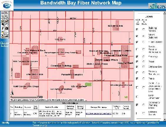
The identify action will
produce a table of results
beneath the map. The
examples to the right and
below show the
information associated
with the Wired
Buildings layer.
The Wired Building
information includes
building manager
website URL which
when selected will open
another browser window with that URL. Close or minimize the new window when you are
finished looking at it so that you can see the Fiber Map application.
Also notice how the map is focused down to the Wired Buildings, which was done by activating
the layer and pressing the 'zoom to active layer' tool ![]() button. As you zoom in more buildings
names become visible.
button. As you zoom in more buildings
names become visible.
QUERYING OR SEARCHING INFORMATION
 Two queries can be made on both the Wired Buildings and on the Fiber Network layers.
For the Wired Buildings, you can search by building name or by which service provider is
wired into it. The queries are selected from a pull down menu that appears when the 'search' ![]() tool is pressed, after activating one of the two layers (Wired Buildings or Fiber Network). When
a successful query is made a new map and table are automatically displayed.
tool is pressed, after activating one of the two layers (Wired Buildings or Fiber Network). When
a successful query is made a new map and table are automatically displayed.
TIP: The queries require that you enter only the first 2 or 3 letters of the name you are
searching on. They are also case sensitive, so names like 'AT&T' must be entered as
'AT',without the quotes.
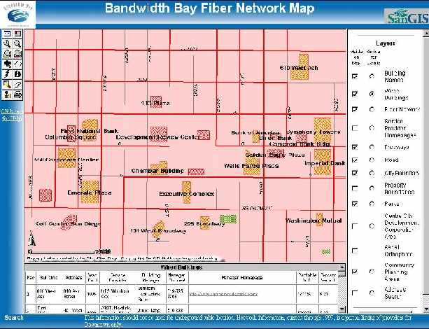
Highlighted in the example above are thirteen buildings that are serviced by Cox
Communications. These buildings were located by searching for building by provider.
TIP: You can ![]() print the table of results using the print icon or by choosing from File then
Print from your browser.
print the table of results using the print icon or by choosing from File then
Print from your browser.
Searches or queries can also
be done on the Fiber
Network layer. One of the
searches will locate and map
streets that are wired by a
given number of providers,
as shown here. This map
shows the streets containing
broadband wiring of three or
more service providers, and
the table below lists the
names of those streets and
providers. The other fiber
network search that can be
performed is to locate and
view all of the streets that are wired by a particular service provider. "
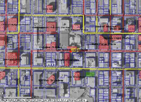
Buildings can also be located either through an address search using the 'locate address' ![]() tool
or by visually identifying the building on the aerial photo. The figure below shows the results of
an address search of city hall, as viewed with the aerial photo and property boundaries.
tool
or by visually identifying the building on the aerial photo. The figure below shows the results of
an address search of city hall, as viewed with the aerial photo and property boundaries.
HYPERLINKS
Hyperlinks for most building managers and broadband service providers are available. When you list or query the Wired Building information the building manager website URL will appear in the table. Clicking your mouse on the URL will automatically send you to the website using a new browser window. Close or minimize the new window when you are finished looking at it so that you can see the Fiber Map application.
To access the Service Provider website URLs, first make this layer active. Then using the
identify ![]() tool click anywhere in the downtown area to get a list of the available service
provider websites. You do not need to refresh the map first. Click your mouse on the URL to
automatically send you to the website using a new browser window. Close or minimize the new
window when you are finished looking at it.
tool click anywhere in the downtown area to get a list of the available service
provider websites. You do not need to refresh the map first. Click your mouse on the URL to
automatically send you to the website using a new browser window. Close or minimize the new
window when you are finished looking at it.
PRINTING
All of the information from the queries can be printed. Maps can be printed in one of two ways.
Use the print ![]() tool to make a printable page, which will appear in a new browser window.
You will be prompted to type your own title that will appear on the printout. The colored legend
will also be on the printout. To send the printable page to the printer use your browser's print
tool to make a printable page, which will appear in a new browser window.
You will be prompted to type your own title that will appear on the printout. The colored legend
will also be on the printout. To send the printable page to the printer use your browser's print![]() button. Alternatively, the map can be saved using a screen capture utility.
button. Alternatively, the map can be saved using a screen capture utility.
Tables can also be printed using your browser's print button.
Acknowledgments: Tim Craig, Esri; Frank Martin, Esri; Derek Danziger, CCDC; Gabriela
Coverdale, City of San Diego


![]()