A Reliable Crop Condition Assessment Program (CCAP) Incorporating NOAA AVHRR Data, a Geographic Information System and the Internet.
Gordon C. Reichert and David Caissy
Spatial Analysis and Geomatics Applications
Agriculture Division, Statistics Canada
Ottawa, Ontario K1A 0T6
Abstract
This paper describes the Crop Condition Assessment Program (CCAP) developed and maintained by Statistics Canada. CCAP is a client/server application developed using MapObjects, MapObjects IMS, Java and Visual Basic. Value-added processing of NOAA AVHRR data during the growing season provides the basis for the weekly, quantitative releases on crop and pasture/rangeland conditions of western Canada and the northern plains of the United States. Value-added products are available on the Internet‡ less than 24 hours after the last satellite overpass used in the weekly image composites. A customized Graphical User Interface (GUI) allows subscribers to interactively view, analyze and compare changing crop and pasture/rangeland conditions on a near real-time basis by region, province, Census Agricultural Region, Census Consolidated Sub-division or county. Spring wheat yields for western Canada are forecast using a linear regression model. Forecast accuracy has been within 5.6% of the published estimates for 10 of the 13 years (1989 to 2001). Spring wheat yield forecasts using NOAA AVHRR data are viewed as an experimental indicator distributed to CCAP subscribers. The official Statistics Canada crop estimates are produced from the field crop reporting surveys.
Introduction
Agriculture is the lifeblood of many nations. It is key to food security, export earnings and local employment. Increasing competition among grain exporters and the instability of grain markets have underscored the importance of having accurate and timely information on supply and demand by exporting and importing nations of the world.
Remote sensing is able to supply the user community with frequent updates on crop conditions over a large geographic area using coarse-resolution (1.1 km at nadir) satellite imagery. Twice daily, the entire earth's surface is imaged by the National Oceanic and Atmospheric Administration (NOAA) series of satellites carrying the Advanced Very High Resolution Radiometer (AVHRR). Although designed for atmospheric observations and weather forecasting, the AVHRR sensor captures two of the most important spectral bands for vegetation monitoring, red and near infrared. In the 1980s, Canadian researchers began assessing the information content of AVHRR digital data for operational monitoring of crops throughout western Canada (Brown et al., 1982, Glick et al., 1984, Prout et al., 1986).
Despite significant annual variations in growing conditions it was possible to produce early season yield forecasts using NOAA AVHRR data. Findings by Quarmby et. al., 1993; Doraiswamy and Cook, 1995; Leprieur et al., 1996; Rasmussen, 1997; Hochheim and Barber, 1998; and Reichert et al., 1998; continue to advance yield forecasting capabilities using NOAA AVHRR data. Demands placed on scientists by private industry, marketing agencies and government to produce accurate, timely production forecasts well in advance of statistical survey estimates, emphasize the importance of using remotely sensed data, a Geographic Information System (GIS) and the Internet.
Statistics Canada's Crop Condition Assessment Program
In 1988, the Crop Condition Assessment Program (CCAP) was developed and implemented by Statistics Canada. Statistics Canada's original interest in establishing a CCAP was to replace the Telegraphics Report Program (TRP) that had been discontinued for budgetary reasons. The TRP was a weekly report of crop growth submitted by 160 individuals from across the country. These reports were supplementary to Statistics Canada's farm surveys on yield and provided information on crop development throughout the growing season. The discontinuation of the TRP left a large data gap in the crop reporting program and the CCAP was evaluated as an ideal project to augment it. The benefits of monitoring vegetation conditions across western Canada using NOAA AVHRR data and GIS capabilities were immediately evident during the drought year of 1988. The success further reinforced the role of remote sensing as an integral part of a crop reporting program, therefore, in 1989 the CCAP was made available to subscribers outside of Statistics Canada (Korporal et al., 1989). At the request of the CCAP users, the area of interest was later expanded to include the northern plains of the United States. Due to logistical reasons, data for both regions of interest were only available from 1993 onward. Therefore the CCAP value-added products available on the Internet reflect this timeframe. The spring wheat yield model for western Canada does however include data from 1989 onward.
Data Processing
NOAA AVHRR data are collected daily throughout the crop-growing season at the satellite receiving station in Prince Albert, Saskatchewan. These data are transferred to the Manitoba Remote Sensing Centre (MRSC), using a file transfer protocol (FTP) connection, where processing is performed using the GeoComp system (Robertson et al., 1992) and the "next generation" GeoComp processor, GeoComp-n (Adair et al., 2002; Cihlar et al., 2002). GeoComp-n is a fully integrated software package that provides end-to-end processing of the AVHRR data. It supports four primary functions: AVHRR data input, pre-processing, geocoding and resampling, and composite product generation. Although the GeoComp-n system produces 40 different composite products, Statistics Canada uses only the red, near-infrared and Normalized Difference Vegetation Index (NDVI) composites.
A 10 day composite similar to the International Geosphere–Biosphere Programme specifications is routinely generated by GeoComp-n (Townshend et al., 1995). The length of a composite period is always a compromise between temporal resolution, amount of residual cloud, and user demands. CCAP user specifications required that CCAP updates coincide with weekly crop reports released by various provincial, federal and private stakeholders. Therefore, a Monday to Sunday compositing period is used within GeoComp-n to produce a weekly, seven-day composite image. Although the seven-day composite period substantially reduced cloud cover problems inherent with daily images it did not always produce a seven-day composite image that was completely free of cloud influence. Conclusions by Hoccheim and Barber (1998) supported the earlier findings of Statistics Canada that cloud affects must be addressed to increase the accuracy and usefulness of the CCAP products. Cloud affected pixels, not eliminated in the seven-day compositing process, are easily recognized in the red spectral band (channel 1). Therefore, to minimize statistical errors that may have been introduced by clouds, Statistics Canada generates a constant threshold cloud mask based on the channel 1 AVHRR composite. The cloud mask is applied to the NDVI composite, as part Statistics Canada’s value-added processing, thereby ensuring that only cloud free pixels are included when computing the NDVI statistics for the image area of western Canada and the northern plains of the United States.
Geographic Information System Interface
A User’s Perspective:
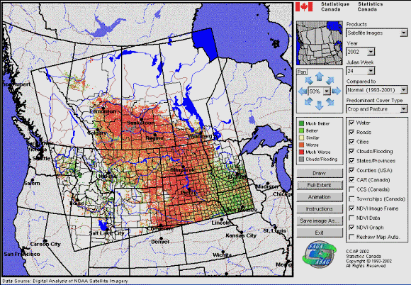
Statistics Canada performs a series of value-added processes to the weekly data as part of the CCAP. Weekly updates are available to CCAP subscribers via the Internet (Figure 1) within two hours of Statistics Canada receiving the composites from the MRSC. In other words, subscribers view Statistics Canada’s weekly value-added products on the Internet less than 24 hours (near real-time) from the last satellite overpass used in the weekly composite. Subscribers can view several types of weekly value-added satellite image and map products, as well as statistical and graphical data (Figure 2). Value-added image products show vegetation conditions on a pixel by pixel basis, while map products illustrate the predominant vegetation condition within western Canada by Census Agriculture Region (CAR) or Census Consolidated Sub-division (CCS); or within the U.S. image region by county.
Interactive value-added image and map products include:
The normal is an average of the NDVI channel for the crop years from 1993 to the year previous to the present growing season. Years of drought and record production are included in the calculation of the normal. Using the GIS interface, subscribers can view cropland and/or pasture/rangeland areas of interest, together or as separate classes. This type of qualitative analysis allows users to quickly assess how much and where week to week conditions have either deteriorated, remained unchanged or improved. Water bodies, rivers, roads and major cities as well as provincial, CAR, CCS, state and county boundaries are overlaid on the image to aid in area location.
A detailed, quantitative analysis is accomplished by calculating the mean NDVI value on a weekly basis for crop and pasture/rangeland masks and for each of the CARs, CCSs and counties. As previously noted, pixels influenced by cloud are excluded from the calculation of the mean NDVI statistics. Mean NDVI data by CAR, CCS or county can be plotted, viewed, compared and analyzed with any other year in the statistical archive. Users have the flexibility to choose the comparison years, electronically export the tabular data or the NDVI curves into reports or presentations, and produce hard-copy prints of the results.
A Programmer’s Perspective:
The CCAP application is divided into two main parts: the client and the server (Figure 3). On the server side, Visual Basic (VB) 6.0 from Microsoft was used as the main programming language. MS-Access 97 was used for the spatial database, Map Objects 2.0a to generate the maps, and Map Objects Internet Map Server (MoIMS) to serve the maps on the Internet. Active Server Pages (ASP) on a Windows 2000 platform provide security with the Internet Information Server (IIS) installed.
On the client side, Java 1.3 was used to create programs, called "applets", that are executed directly in a browser. Java is a powerful language that allows the application to take full advantage of all the possibilities offered by Map Objects.
CCAP is a client-server application based on an n-tier model. This means that the client and the server do not "talk" directly to each other, but use intermediates to do so.
In this example, a client enters a username and password to access the Java applet. The ASP page verifies client status, grants access to the applet and opens it. The Java applet "CCAP.java" is automatically downloaded and executed in the client’s internet browser where the applet displays a map representing the current crop and pasture conditions. To do so, the applet "CCAP.java" sends a request to a Java class named "NetworkComm.java".
"NetworkComm.java" is not an applet. Its role is to encapsulate everything concerning the communication on the Internet. This is the first intermediate between the client and the server in the n-tier model. This class transmits the request for a map made by the client via the internet and through the host firewall to "Esrimap.dll".
The second intermediate, "Esrimap.dll", receives the request for a map from "NetworkComm.java" and dispatches the request to the VB application called "CCAP.exe".
"CCAP.exe" uses Map Objects components and the data stored in the database to generate a dynamic map. Once this map is created, it is converted to a GIF image and is sent back to "Esrimap.dll" and from there to the "NetworkComm.java" class which retransmits it to the applet "CCAP.java".
There are several advantages to using an n-tier client-server model. For example, migrating from MoIMS to ArcIMS requires only minor modifications to "CCAP.exe" and "NetworkComm.java" without changing a single line of code in "CCAP.java"! Since "NetworkComm.java" is considerably smaller than "CCAP.java" it is also easier to maintain.
Several server applications within the Crop Condition Assessment Program use the same "Esrimap.dll". By doing so, the source code is re-used thereby improving efficiency while eliminating redundancy.
Spring Wheat Yield Model
The yield model has been developed to forecast spring wheat yields at the CAR level throughout western Canada. Spring wheat is the most extensive crop grown in western Canada, accounting for about 50 per cent of the area seeded to the six major grains. The coarse-resolution of the AVHRR sensor makes visual differentiation of one crop from another impossible. Information acquired by the satellite over western Canada is dominated by spring wheat; therefore, changes in NDVI are often a result of changing spring wheat conditions. Consequently, the linear regression model used for this study deals only with spring wheat.
NDVI values typically reach maximum levels between early July and mid-August, then decline as the vegetation ripens. During this period the historical NDVI values for each CAR are correlated with Statistics Canada's historical survey spring wheat yields using a linear regression model. The linear relationship is applied to the current season’s NDVI value for each week between early July and mid-August and a forecast yield at the CAR level is calculated. Spring wheat production is predicted by multiplying the forecast spring wheat yield by the seeded area from the current season small area statistics recorded by Statistics Canada's field crop reporting series. Production forecasts at the CAR level are aggregated to the provincial level and a weighted forecast yield calculated for western Canada. The first of seven weekly spring wheat yield forecasts is released eight weeks in advance of Statistics Canada’s first spring wheat yield estimate. Reliable forecasts well in advance of other credible sources are invaluable to CCAP users.
Preliminary spring wheat yield forecasts compared to Statistics Canada's final published spring wheat yield estimates have varied from year to year. For the purposes of this paper, accuracy comparison is based on Statistics Canada’s final spring wheat yield estimate of the year as part of the publication entitled "Estimates of Principal Field Crops Production", released in December, well after the harvest has been completed. The final forecast accuracy has been within 5.6% of the published estimates for 10 of the 13 years (1989 to 2001) (Table 1). Adverse weather conditions during the growing season can affect the forecast results as was evident in 1989, 1993 and 1995 (Reichert, 1995).
Summary and Conclusions
Statistics Canada’s use of AVHRR data provides timely and reliable information on crop and pasture/rangeland conditions. Because of the research interest of the federal, provincial and private stakeholders, the focus has been the development of coverage for the predominantly spring wheat growing regions of western Canada and the northern plains of the United States. A composite of AVHRR images covering the latest seven-day period removes most or all cloud effects, which substantially improves the quantitative capability of the CCAP. Statistics Canada releases the weekly CCAP update on the Internet less than 24 hours after the last satellite overpass used in the composite image. This timeliness from satellite to user is invaluable when management decisions require the most up-to-date information possible as to how much and where week to week conditions have changed. CCAP updates, provided on a weekly basis via the Internet‡, ensure that all users receive the information as soon as possible. In addition, reliable spring wheat forecastsĄ for western Canada are provided well in advance of Statistics Canada’s first survey information on spring wheat yield which is based on farmer observations. Users demands to produce accurate, timely production forecasts well in advance of statistical survey estimates re-emphasizes the importance of using remotely sensed data, a Geographic Information System (GIS) and the Internet.
A close working association with end-users has been paramount to the successful development and deployment of the CCAP. Additional research efforts that incorporate the strengths of agrometerological and remotely sensed data are recommended to further improve the CCAP and the spring wheat yield model, especially in years of adverse weather conditions. These refinements would ensure that the CCAP continues to meet the evolving needs of the users.
Figure 1. Internet Graphical User Interface for the Crop Condition Assessment Program.
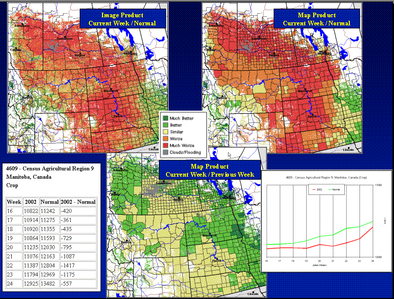
Figure 2. Value-added products available through the Crop Condition Assessment Program.
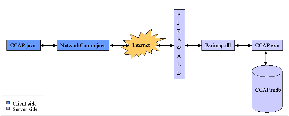
Figure 3. CCAP client-server n-tier model.
Table 1. Spring Wheat Yield Forecasts for western Canada based on NOAA AVHRR Satellite Data.
|
Western Canada |
1989 |
1990 |
1991 |
1992 |
1993 |
1994 |
1995 |
1996 |
1997 |
1998 |
1999 |
2000 |
2001 |
|
|
Forecast1 (bu/ac) |
28.8 |
34.9 |
31.3 |
31.0 |
29.0 |
29.5 |
29.4 |
35.2 |
33.2 |
31.8 |
36.7 |
34.6 |
28.8 |
|
|
Statistics Canada Pub2 (bu/ac) |
26.8 |
33.7 |
33.1 |
31.3 |
32.0 |
30.7 |
32.3 |
36.1 |
31.5 |
33.4 |
37.7 |
36.1 |
27.4 |
|
|
Forecast vs Published |
7.4% |
3.6% |
-5.5% |
-0.9% |
-9.4% |
-3.9% |
-9.0% |
-2.6% |
5.6% |
-4.8% |
-2.7% |
-4.2% |
-4.8% |
1
Forecasts are viewed as an experimental indicator distributed to CCAP subscribers for evaluation purposes only. The official Statistics Canada crop estimate is based on the Field Crop Reporting Surveys.2
Statistics Canada, Field Crop Reporting Series, 1989-2001.
References:
Adair M., J. Cihlar, W.M. Park, G. Fedosejevs, A. Erickson, R. Keeping, D. Stanley, and P. Hurlburt. 2002. GeoComp-n, an advanced system for generating products from coarse- and medium- resolution optical satellite data. Part 1: System characterisation. Canadian Journal of Remote Sensing , 28(1) pp. 1-20.
Brown, R.J., M. Bernier, G. Fedosejevs and L. Skretkowicz. 1982. NOAA - AVHRR Crop Condition Monitoring. Canadian Journal of Remote Sensing, 56(10) pp. 1359-1365.
Cihlar J., J.M. Chen, Z. Li, R. Latifovic, G. Fedosejevs, M. Adair, W.M. Park, R. Fraser, A. Trishchenko, B. Guindon, D. Stanley, and D. Morse. 2002. GeoComp-n, an advanced system for the processing of coarse and medium resolution satellite data. Part 2: Biophysical products for northern ecosystems. Canadian Journal of Remote Sensing , 28(1) pp. 21-44.
Doraiswamy, P.C. and P.W. Cook. 1995. Spring Wheat Yield Assessment Using NOAA AVHRR Data. Canadian Journal of Remote Sensing, 21(1), pp.43-51.
Glick, J.L., J.F. Benci and R.J. Brown. 1984. Operational Crop Forecasting Using Remotely Sensed Imagery. Proceedings of the 8th Canadian Symposium on Remote Sensing, pp. 331-341, Canadian Remote Sensing Society, Ottawa, Ontario.
Hochheim, K.P. and D.G. Barber. 1998. Spring Wheat Yield Estimation for Western Canada Using NOAA NDVI Data. Canadian Journal of Remote Sensing, 24(1), pp. 18-27.
Korporal, K.D., Dobbins, R. and N.M. Hillary. 1989. The Statistics Canada Crop Condition Assessment Program, Proceedings of the 12th Canadian Symposium on Remote Sensing, pp. 2006-2009, Canadian Remote Sensing Society, Ottawa, Ontario.
Leprieur, C., Y.H. Kerr, and J.M. Pichon. 1996. Critical Assessment of Vegetation Indices From AVHRR in a Semi-arid Environment. International Journal of Remote Sensing, 17(13), pp. 2549-2563.
Prout, N.A., Sutton, J., Wessels, J., Manore, M., and R.J. Brown. 1986. Technological Feasibility to Mobilization for Operations: The NOAA Crop Monitoring Case, Proceedings of the 10th Canadian Symposium on Remote Sensing, 2, pp.787-796, Canadian Remote Sensing Society, Ottawa, Ontario.
Quarmby, N.A., M. Milnes, T.L. Hindle, and N. Silleos. 1993. The Use of Multi-temporal NDVI Measurements from AVHRR Data for Crop Yield Estimation and Prediction. International Journal of Remote Sensing, 14(2), pp. 199-210.
Rasmussen, M.S.. 1997. Operational Yield Forecast Using AVHRR NDVI Data: Reduction of Environmental and Inter-annual variability. International Journal of Remote Sensing, 18(5), pp. 1059-1077.
Reichert, G.C. 1995. Agriculture and Remote Sensing. Bi-Weekly Bulletin. Agriculture and Agri-Food Canada, 8(18), pp. 1-6.
Reichert, G.C., P.R. Nixon and R.N. Dobbins. 1998. Statistics Canada’s Near Real Time Crop Condition Assessment Program Utilizing NOAA AVHRR Data – Remote Sensing , GIS and the Internet. Proceedings of the International Conference on Agricultural Statistics, pp. 142-148, Washington, D.C.
Robertson, B., A. Erickson, J. Friedel, B. Guindon, A. Sanz, T. Fisher, R. Brown, P. Teillet, M. D'Iorio, J. Cihlar, and A. Sancz. 1992. GEOCOMP, a NOAA AVHRR Geocoding and Compositing System. Proceedings, ISPRS Conference, Commission 2, pp. 223-228, Washington, D.C.
Townsend, J.R.G., C.O. Justice, D. Skole, J-P. Malingreau, J. Cihlar, P.M. Teillet, F. Sadowski, and S. Ruttenberg. 1995. "The 1 km resolution global data set: needs of the International Geosphere – Biosphere Programme". International Journal of Remote Sensing, 15(17), pp. 3417-3341.
Statistics Canada. 1989-2001. Field Crop Reporting Series, Cat. No. 22-002-XPB, Agriculture Division, Statistics Canada, Ottawa, Ontario.