Empowering Municipalities to Plan for Future Development: A University Public Service Partnership
Alexander Settles
This paper presents the work of the Institute for Public Administration at the University of Delaware in partnership with the Office of State Planning Coordination to develop a range of geographic information system tools for use by small local governments to allow them to plan for their future. These projects began with the development of paper maps to represent different growth and development scenarios. The program has evolved to the distribution of customized Arc Explorer applications for use by local governments. This paper identifies implementation issues concerning end users with limited technology experience and limited access to the Internet. Introduction The Institute for Public Administration (IPA) has a long tradition of more than 25 years of working with Delaware's municipalities, county governments, and local government associations, as well as other governmental agencies and civic organizations concerned with local government issues. Local government research and technical assistance forms the core of the Institute's efforts and has involved planning services for municipalities, convening the Delaware Institute for Local Government Leaders (DILGL), policy research on statewide local government issues, research and technical reports for individual municipalities, and support of local government organizations to foster intergovernmental coordination between municipal, county, and state governments.
The IPA’s Planning Services Team offers a wide variety of planning services to local, state, and regional governments in the Delaware. The IPA combines the professional planning experience and research skills of its staff with the resources of the University of Delaware to maintain its rich tradition of providing service and assistance to municipalities. Assisting the group's work is the contribution of the Water Resources Agency, a unit of IPA, which offers its expertise in watershed planning, computer mapping, and geographic information system (GIS) development.
Local planning projects have included:
The Town of Millsboro Project
The town of Millsboro contracted with the Institute for Public Administration to update the town’s comprehensive development plan. Millsboro is a small town in Sussex County, Delaware with less than 1,700 residents and a limited town staff. The town has no land use planner and did not use geographic information systems. The IPA has used GIS to develop map products for comprehensive plans for other small towns. After consultations with the Town staff, I conducted a pilot project with the town to develop a geographic database that would be used by the town staff and updated by the Institute staff.
IPA staff and graduate students collected data and developed maps for the project. I, as the project planner, selected the types of data and specified which maps to use. We have developed these map series using GIS as part of our regular planning process. During the course of this project we conducted a pilot project to distribute GIS software and data in a format that very small communities with limited resources and no background in using GIS technology.
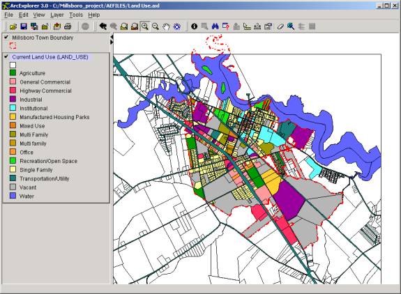
Utilizing Arc Explorer 3, a series of project files were created and basic information provide to the town for their use in the administration of the town. Building on a tax record spreadsheet database, I constructed an Arc Explorer project that connected tax parcel information with tax parcel polygons and field verified land use data. Figure 1 is a snapshot of the project.
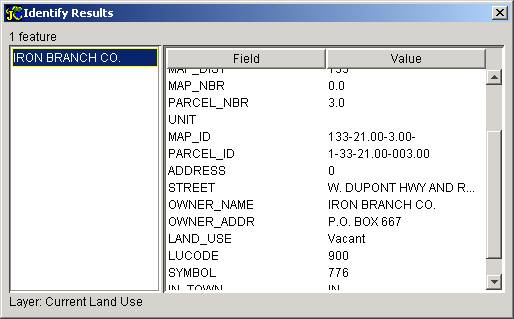
I worked with the town to defined what data the town manager and administrative assistant needed from the database. The database included tax parcel identification numbers, ownership, tax assessment, zoning, land use, and map reference information. The administrative assistant in charge of property tax billing maintained tax assessment and ownership information. The following figure is a snapshot of the identify results for the land use.
Installation The planning maps were provided to the town during the comprehensive planning process during 2000 and 2001.In the winter of 2000 to 2001 the Arc Explorer database was installed and tested at the town. The town, at that time, had two desktop Pentium II computers that used Windows 98. The installation of the database and Arc Explorer software was problematic due to the town’s limited computing power and significant differences between the capabilities of the university’s systems and the town’s system. Connection to databases housed at the IPA also proved problematic due to the limited bandwidth available to the town. The town manager was able to review the software and database but did not adopt the technology into the process of administering the town due to hardware problems and lack of time to learn the software. The paper maps continue the product most often used by the town. Conclusions The University provides an environment for experimentation in the use of GIS software and the provision of geographic databases for local government use. I have found it difficult to interest the very small towns that we work with to adopt the use of GIS.In general town managers and other local official prefer to have the IPA and WRA to conduct geographical analysis and produce maps for their use. We have continued to develop databases for use by local government but there has been limited interest in the use of viewer software by the towns that we have worked with on comprehensive plans. Portable document formatted (pdfs) maps have remained the most popular format for Internet distribution.
Alexander Settles
Assistant Policy Scientist
180 Graham Hall
Institute for Public Administration
University of Delaware
www.ipa.udel.edu web page
asettles@udel.edu e-mail
302-831-8971 phone/voice-mail
302-831-3488 fax