 Encroachment GIS Strategies
Brian VanBockern, AICP
Southern Division Naval Facilities Engineering Command
Introduction
Navy and Marine Corps installations are faced with an ever-increasing array of encroachment pressures from numerous sources. Encroachment can take the form of incompatible adjacent development/land uses. Operational impact severity increases due to density changes or various natural resource and environmental factors that would inhibit normal operations or utilization. Identification of encroachment typically occurs rapidly, but the management and monitoring of the problem is where the real challenge occurs. Proper management and monitoring is the greatest aid in heading off additional encroachment and identifying the most effective strategy to abate the severity of the problem. Installations that have Geographic Information Systems (GIS) established can adapt and enhance their systems to aid in the encroachment management process. The question many installations ask is what data and techniques for GIS would aid the cause?
The following advice and methods have been derived from actual situations and the names have been removed to protect the guilty and innocent. A simple checklist has been developed at the end that will aid installations that are new to the encroachment management idea.
Encroachment Management Paradigm
The types of data needed for effective encroachment management can vary from case to case but on the whole there are certain datasets that need to be acquired. In all cases the installation’s GIS needs to have all the typical foundation/base mapping layers in order to depict the “inside the fence” situation.
Use of a proper and accurate Air Installation Compatible Use Zone (AICUZ) and Noise Contour study can readily aid in identifying zones of protection needed to stem the tide of encroachment. In the cases of other types of operations, like gunnery ranges, the appropriate constraint layer is needed (i.e. Surface Danger Zones-SDZ). In many cases the encroachment has already begun and AICUZ only aids in preventing further densification. Accuracy in use of an AICUZ can mean a lot of different things. Accuracy of the study is one thing however accuracy of the drawn lines geographically has a set of issues all its own. For installation other that Air Facilities the strategies outlined will also be beneficial.
Accurate AICUZ and noise maps can only be compiled if the project scope has adequate provisions for proper digital deliverables. Once a good AICUZ and noise contour is available then the real fun can begin. The pursuit of additional layers to execute encroachment management will require some money and a fair bit of time and coordination. The first thing would be to coordinate with your local and county planning agencies to arrange the exchange of data. Data exchange will hopefully foster a working relationship at the technical level that can translate into other data exchanges beneficial to both sides. Initial data gathering should include Zoning (current and proposed), Land Use (current and proposed), parcel maps, roads and any other layers that would depict the city and/or county situation. One data set that may need to acquired separately, depending on the locality, is geocoded streets. These are invaluable for address matching functions that will be described in detail later.
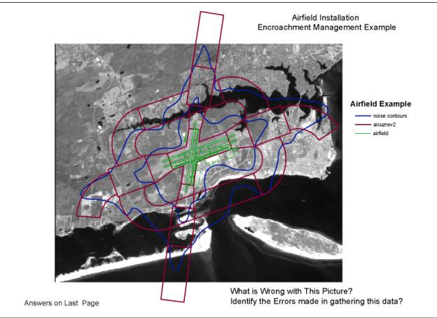
Figure 1
Once all the Data has been gathered in rolled into the GIS then the interrelationships of the data becomes the focus area.
Managing the Encroachment Problem
Use of the GIS to manage encroachment is an obvious solution to a difficult problem. By bringing in all of the multi-scaled data the interrelationship of the data to one another becomes a management issue. Before proceeding with any analysis and tracking from which management decisions will be made certain disclaimer must be highlighted. Common issues that need to addressed include
- Disparate accuracy relationships due to the fact that the installation GIS will usually have a horizontal accuracy in the centimeter/decimeter range and the maps from city and county source can errors of up to 50 feet.
- Constant updating of the non-DOD data sources is required since frequent zoning changes and/or variances occur that could dilute the decision accuracy.
Analysis Functions
Identification of Encroaching zoning changes: Certain rezoning actions and patterns in variance granting can be tracked and certain zoning categories should be watched closely depending on the operations occurring on the installation. For example all types of residential development should be watched closely around airfield facilities.
Identification of incompatible land uses: Certain land use categories should be watched so that when City and County Comprehensive Plans are under review, the installation can participate and highlight the incompatible land uses and their adjacency to the installation within a given distance. For example, range facilities using air-to-ground and ground-to-ground ordnance would not be advisable for certain livestock (Agricultural), residential and specific commercial land uses. By interjecting in the long range planning actions an installation can slowly avert some encroaching practices.
Operations analysis and its relationship to specific demographics, natural environment conditions and land use: Once the operational impacts of the installation have been identified then interrelating those impacts to geographic conditions becomes very applicable. Previous experience has shown that a certain demographic has more complaints with noise issues. One other consideration would be that certain atmospheric condition propagates noise levels. Simple scheduling techniques coordinated with environmental condition monitoring could lessen the impact on demographic clusters or any other outside the fence zone. Understanding all the interrelationships and using GIS as the decision methodology aids in readily identifying the issue and suggesting resources to lessen zonal impacts.
Tracking of specific complaints by geographic location (address matching): The use of geocoded street GIS layers has become a critical tool in identifying specific complaints, tracking those in databases, and highlighting trends that may lead to another analysis area to be addressed. Assumptions of operational impacts may be validated or issues with the assumptions may need to be updated if anomalies occur in the trend analysis.
Identification of land management zones: Once all the analysis and identifications have occurred then the installation should sit down and identify land management zones in the outside community. These zones aid in the monitoring phases whereby if a change were proposed then the installation would hopefully spring into action to address the change and ensure compatibility. For air facilities the compatible use zone programs accomplish this process. Other installation types usually do not have such an analysis tool so methods like those above need to be used if encroachment is a problem. Even air installation compatible use zone programs leave some holes that methods identified above can readily enhance that formalized program.
Figure 2
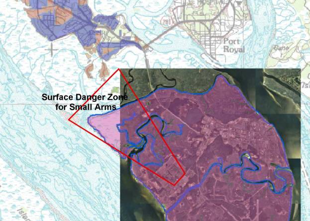
What was missed in the system setup? Answers last page
Can you identify the encroaching zones?
Areas of Concern/Lessons Learned
Data Accuracy: Several items of concern or disclaimers were noted above. The accuracy issue has some far-reaching legal implications that must be monitored. In cases where zoning or land use changes are challenged by the installation, due to incompatibility, the horizontal accuracy of the data becomes a driving force. It can be argued that the interrelationship of a use zone and the data outside the fence is inaccurate. Private parties involved may demand formal surveys that are very costly and time consuming. Challenges of this nature are typically threatened and never exercises but things can rapidly spin out of control if the data accuracy interrelationships are not documented.
Maintenance Methods: When any of this data is compiled or gathered, ensure that full metadata is generated. Enhance any metadata for accuracy to include method of generation in detail. Use a high accuracy GPS to establish an interrelationship grid for the data sets and generate an error factor that can be attached to the data. Document the accuracy factors in the metadata. Therefore when someone challenges the data all the facts are available and recourse can be readily identified. If the data is severely unaligned then formal updates may need to occur to avoid potential challenges.
Formal Relationships with the Local Planning Agencies: The establishment of formal relationships with local planning agencies can go along way to the creation of listening posts for information flow. Getting jump on potential encroachment aids in use of effective resolution techniques. Rapid reaction methods typically have moderate success. Geographic Information Systems is the common language that the 2 entities can use to communicate and facilitate better information flow.
GIS Data Maintenance: Too often military installations struggle with the maintenance of their datasets. The implications involve the lack of confidence in portions of the GIS and usually the entire system. Proper resource allocation for an installation’s GIS is critical to encroachment management. Without accurate data the system is meaningless. Processes to gain executive support for GIS creation and maintenance are well known through examples provided by select Marine Corps and Navy activities. Creation of a comprehensive data maintenance plan would aid in alleviating certain data maintenance hurdles.
Global Positioning Units (GPS): The purchase of a GPS by an installation can go along way in refreshing, maintaining, and creating new data for the GIS. This invaluable tool can return its investment within weeks by accelerating data management processes. Its use for encroachment management can range from clean up of existing datasets to the plotting of outside the fence activities or features that may aid in the overall mission of monitoring and mitigating. A GPS’s main value lies in improving the overall quality of the data. Techniques for data enhancement are well documented and will not be discussed in detail for this topic.
Frequent Aerial Photography or Satellite Imagery: A critical and easily executable tactic in encroachment management is establishing a flyover update program for the command. Typically we suggest the establishment of a flyover update sequence predicated on the installation type. Airfield facilities are on a very frequent update cycle, ranging from 1 to 3 years. Other installation types will range from 2 to 5 years depending on installation and surrounding community change rates. Through cooperative agreements with adjacent partners, the cost burden can be shared. Also the reuse of control networks can reduce the follow-on flyovers. The linchpin of the process comes in the identification of a proper study area. If the aerial photography does not cover enough land area for correct monitoring then it may lead to some credibility loss. By using the operational impact layers and local zoning layers a GIS manager can identify the chosen study area and then add 20-30% for safety. Due to recent cost reductions in flyovers the addition of extra land area has a minimal impact for most installations. This data tool in probably the most important asset in the GIS database and gains extra points with the executives due to its cross-compatibility with other endeavors, not to mention a nice picture for the Command’s wall.
Conclusion
Encroachment management is a challenging problem for many of today’s military installations. Use of coordinated and properly resourced geo-spatial methodologies and data can go along way in monitoring and mitigating encroachment activities. Use of techniques and processes noted above will aid local military decision makers in selecting the proper responses, based on the quality of their data, and hopefully avoid any potential legal challenges. Geographic Information Systems is the right tool and provides the right methodologies to accomplish this critical constraint for the Department of Defense. Investment in the quality of that data and a comprehensive maintenance plan is required to achieve confidence in the results of system outputs.
Answers to Figure Questions
Figure 1:
Data was compiled incorrectly, in that the coverage area was not extensive enough to cover all military operation impacts. A few extra dollars ($2500) in this case would have solved the problem
Figure 2:
The surface danger zone of the range extends into water and lands outside the boundary. Adequate data was not gathers for these impacted zone. The city to the north has encroaching low-density residential development due to high demand for waterfront lots.
Encroachment Management Checklist
1. Verify Accuracy of existing data for the installation
2. If data is inaccurate, then either procure new data or attempt to enhance existing.
3. Make contact with local agencies (planning, conservancy, public works) that may have adjacent land data sets for GIS.
4. Acquire Geocoded street dataset for locational analysis.
5. Acquire Demographic and other Geographic data as needed.
6. Determine accuracy of the new data.
7. Integrate data into common geographic space and analyze for interrelationship anomalies.
8. Establish aerial photography agreement with local governments or set up acquisition strategy for update flyovers.
9. Develop Methodologies for analysis that suits the encroachment problem. For example on airfields and noise you would want to track noise complaints by location while reference temporally and atmospherically.
10. Establish a comprehensive data maintenance plan with support from management.
11. Share the data where appropriate. Exposure and publicity is vital to GIS success.