Authors Names:† Lawrence L. Thornton, M.S. (NJDEP),
Lou Jacoby (NJDEP), Tim Huizing (NJDEP)
The New Jersey Department of Environmental Protection (NJDEP) has several large databases of environmental information. The New Jersey Environmental Management System (NJEMS) is an integrated transactional Oracle database that contains the NJDEP's major program databases. To help all the potential users of this vast amount of data, the NJDEP has developed an online ArcIMS application called i-MapNJ. The NJDEP has recently added additional access to other relevant databases and has integrated the report writing and graphing functions of Business Objects WebIntelligence to the i-MapNJ application.† The resulting online application is called ArcIntelligence. Users can perform both spatial and data reselects in i-MapNJ then pass the data to WebIntelligence where custom reports have been created.† The report data can then be reselected and modified in WebIntelligence and passed back across a bridge from WebIntelligence for viewing and further manipulation in i-MapNJ.† ArcIntelligence allows users the flexibility and power of data and spatial manipulation in an online application easily accessible to users. The goal is to give users access to a tool that will improve the environmental decision making process.
i-MapNJ
The NJDEP, working first with American Management Systems (AMS) of Fairfax, Virginia and currently with Cybertech Systems Inc., of Oak Brook, IL, has been developing its web-based interactive mapping application, i-MapNJ, for several years.† The application uses Esriís ArcIMS and ArcSDE technologies for serving NJEMS (New Jersey Environmental Management System) Oracle-based permitting and agency activity data along with other GIS spatial data.† The application can be used to perform simple queries on the data layers and have the results presented to the user on a map image.
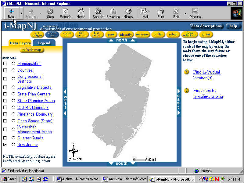
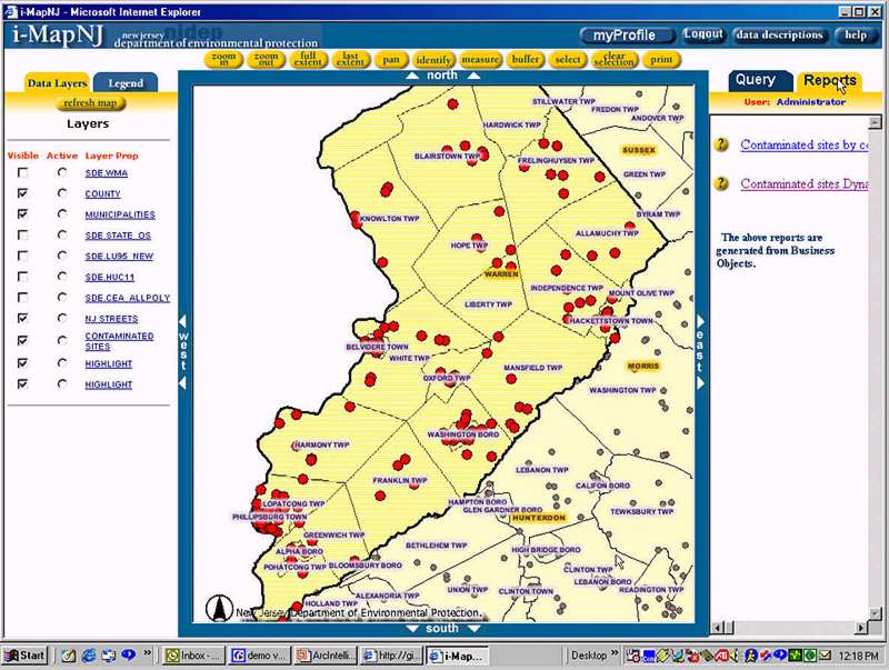
NJDEP debuted i-MapNJ initially as an Intranet application in the fall of 2000.† The application simplifies the process of accessing and viewing environmental information related to regulated sites in NJEMS in a web-based environment.† The application is designed to enable users at various levels of GIS ability to perform site searches and basic spatial analyses. Results from the site searches can be displayed with a number of GIS data layers including current digital orthophotography, land use/land cover, hydrography, roads, and watersheds. Further analysis can be performed using GIS tools in the i-MapNJ Map Tools toolbar.† Using this toolbar, users can perform standard GIS functions such as zoom in, zoom out, last extent, pan and measure. In addition they can buffer layers and print the result with a legend and north arrow.
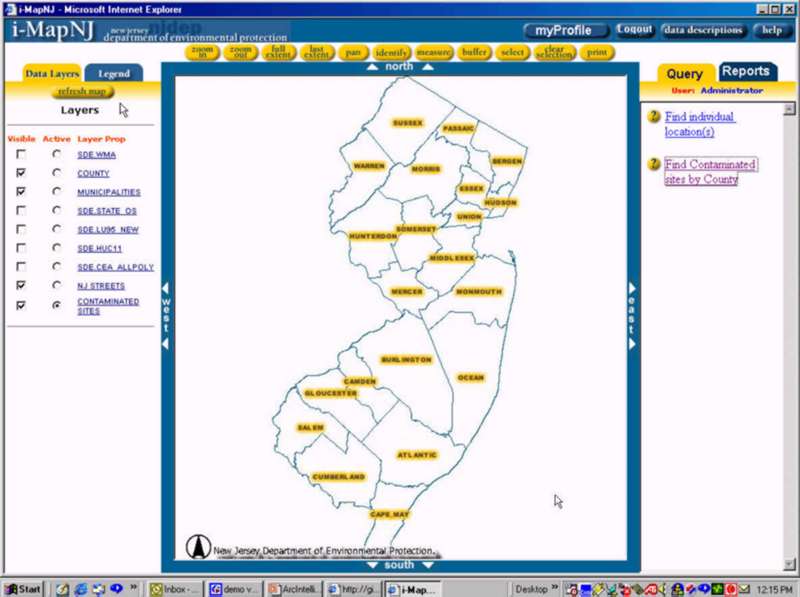
Figure 1 Ė i-MapNJ Internet user interface
As of mid-June 2002, NJDEP is very close to deploying i-MapNJ as an Internet application.† The Internet version will retain most of the queries and tools found in the Intranet version.† NJDEP plans to allow access by Internet users from NJDEPís GIS web page at† www.state.nj.us/dep/gis as an interactive mapping application. With help from i-MapNJ, NJDEP can provide anyone with Internet access the ability to create a map using NJDEP regulatory and environmental data.
The initial version of i-MapNJ sparked a great deal of interest among various programs in the NJDEP.† Several NJDEP programs came forward pitching new ideas for enhancements that would fulfill the needs or requirements necessary to make additional data and mapping services available to NJDEP staff, the regulated community, and the general public.† The NJDEP needed a design able to accommodate several program specific user profiles that would present a customized interface to individual users including GIS layers of interest to the program, GIS tools, outputs, and tailored queries.
As discussions progressed, staff in NJDEPís Bureau of Geographic Information and Analysis (BGIA) was introduced to a web-based data manipulation and reporting software developed by Business Objects called WebIntelligence.† Staff at the BGIA thought that by building a bridge between WebIntelligence and ArcIMS, and integrating them, a very powerful application could be developed to take advantage of their respective strengths.† ArcIMS would provide the map-serving environment, GIS tools for basic spatial analysis, and allow users to perform several canned data queries.† In WebIntelligence spatial feature results from ArcIMS queries could be passed into a WebIntelligence data universe for further data association, linking to additional data.† The data set could be further manipulated and then re-mapped on the ArcIMS side, or output to an external data file for further analysis.
The NJDEP has been working with CyberTech Systems, Inc. since April 2002 to begin development of a much more expanded version of i-MapNJ.† The NJDEP views the i-MapNJ application as an enterprise solution for web-based mapping applications for the agency.† The initial version of the application was developed using the out of the box, HTML based viewer with much JavaScript customization and ASP based pages for the query wizards. As the size and complexity of the application continues to grow in the future, NJDEP would need a different model.† A thinner client would enable better performance and present fewer restrictions.† Therefore, it was decided to investigate new client-server architecture.† The NJDEP and CyberTech examined several different client server models.
By mid-June 2002 CyberTech Systems, Inc. had completed the design phase for the project, including the new client-server architecture, and had begun application development.† CyberTech had demonstrated the ability to link ArcIMS and WebIntelligence in a simple prototype.†† CyberTech also demonstrated the User Profile module that allowed users to access a customized profile based on their NJDEP program affiliation.† With work proceeding through the summer of 2002, it is estimated that the completed Intranet application will be delivered in September 2002.† The NJDEP hopes to have a completed Internet version by the end of 2002.
The initial version of i-MapNJ was developed using the HTML viewer from ArcIMS version 3.0.† The HTML viewer had been chosen since it could be customized and did not require users to download any supporting files for Java (Java run-time environment and Java applet).† This was a big consideration since the ultimate goal was to eventually serve the application on the Internet, and the NJDEP did not want to burden outside users with the need to download the Java support files.† For the NJDEPís initial version of the i-MapNJ application, the HTML viewer worked fine.
From discussions held with representatives of Esri and CyberTech it became clear that NJDEP needed to strongly consider a significant restructuring of i-MapNJís client-server architecture before moving ahead with further development.† Though the out-of-the-box ArcIMS HTML client is thinner than the Java clients, even thinner clients could be developed for the application.† In this setup, more processing work is done on the server side, reducing the request/response trips between server and client.† This is ideal particularly for the Internet where most users do not have broadband high-speed connections.†
Several thin client options exist, though NJDEP only seriously considered the Java Application Server Link, and Microsoft ActiveX technologies.† In the end, NJDEP opted to go the ActiveX route for several reasons: the most important being that BGIA staff have staff expertise in the Microsoft development tools (ASP, COM, and Visual Basic) and little Java development background.† This was a key factor since a major aspect of the project is knowledge transfer sessions between the CyberTech developers and BGIA staff that would, in the future, maintain and continue the development of the application.† At the time the client-server decision was made, the current version of ArcIMS was 3.1.† Not much later, version 4.0 was released.† The decision was made to develop the new version of i-MapNJ in version 3.1 of ArcIMS with plans to migrate to 4.0 during the Internet version development phase.
NJDEP currently has a site-wide license for Business Objects.† The Business Objects WebIntelligence application has been used in recent years by NJDEP staff for generating tabular reports, mainly on NJEMS data.† WebIntelligence has an easy to learn drag-and-drop interface that allows new users to accomplish data related tasks simply and quickly. The creation of WebIntelligence universes for these databases allows users to develop custom data queries while in the WebIntelligence environment and not limit them to only the canned queries found in the i-MapNJ environment.† Accessing these other resources of environmental data is very important and necessary to support i-MapNJ 2.0 development.
Business Objects is a suite of software products that allow users to develop report and graphs from tabular data. Included in Business Objects are WebIntelligence, Business Objects, Designer and Supervisor.† WebIntelligence is a portal on the NJDEPís intranet site, available to all staff, used for report development, display of graphs and execution of queries. Users need only a web browser on their computers to access WebIntelligence functionality. WebIntelligence is designed for the novice user to generate queries and run existing reports on existing database data such as NJEMS or NJSTORET.† Once a database is queried, users can then view the document in tabular format or produce complex drillable charts.† These can then be saved for personal use, sent to other users, or published to a corporate repository where all can view them.
Business Objects is a client application used by technical experts to develop complex queries and reports that cannot be created in WebIntelligence.† It is used when a proposed report or query must utilize more complex SQL functions such as unions, minuses or subqueries.† An SQL technical expert uses Business Objects to publish reports, queries and graphs that are beyond the capability of WebIntelligence.††††
Designer is used to develop program specific report writing universes. Within NJDEP each program has been designing its own specific universe.† A universe is a sub model of the databases that a user can access showing joins between tables. Data in the column can be sorted using SQL statements to help users view standardized, normalized data.
Supervisor is the software that controls the security functions in Business Objects. All users rights are controlled in Supervisor.† Supervisor restricts the availability of WebIntelligence functionality, such as access to particular databases, documents or universes users can access for creating and editing queries.† Users can access only files they are authorized to see. Rights can be assigned to individual users as well as groups of users. The security functions of WebIntelligence are integrated within i-MapNJ 2.0 ArcIntelligence user profiles.† A user of the new i-MapNJ Ė ArcIntelligence application will nee to perform a single logon sequence to gain access, and once logged on may switch between i-MapNJ and WebIntelligence environments freely.
Most NJDEP staff will use only the WebIntelligence component of Business Objects.† Exceptions would be those in charge of advanced functions such as, designing universes, giving permissions or performing advanced report and query generation
When users log in to WebIntelligence they are presented with a customized interface called NJDEP InfoVIEW. (See Figure 2)
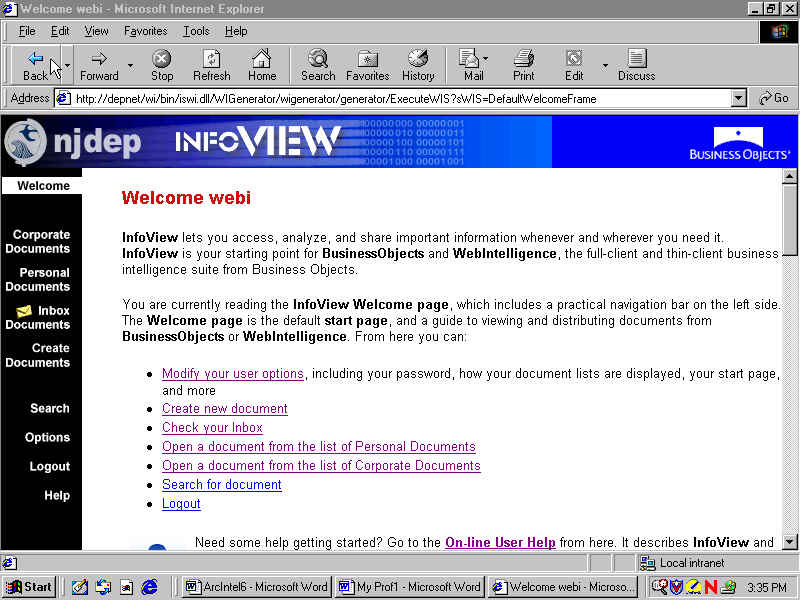
Figure 2 Ė WebIntelligence InfoVIEW user interface
Hyperlinks in the left frame of the InfoVIEW give users access to various document functionality. Corporate documents are documents that have been published and made accessible to groups of users within an organization.† Personal documents are documents that users have saved to their personal storage area for their own use. Inbox Documents contains documents that other people have created and mailed. Extensive context sensitive help files are available to assist the user.
When users choose to create documents they are taken to a page that allows them to pick which universe to create the document in. (See Figure 3)
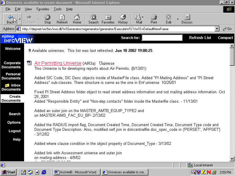
Figure 3 Ė WebIntelligence Universes available to create documents.
Users are then able to drag and drop objects (columns) from the existing tabular information to create a new document.† (See Figure 4)
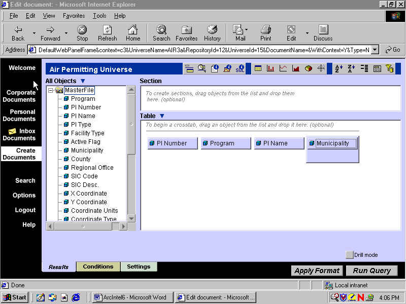
Figure 4 Ė WebIntelligence edit document page.
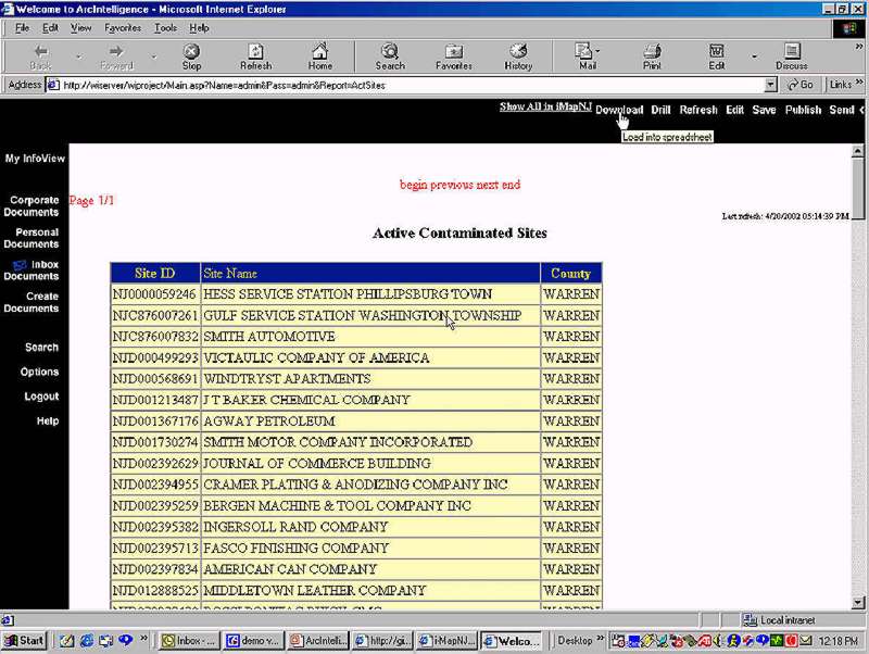
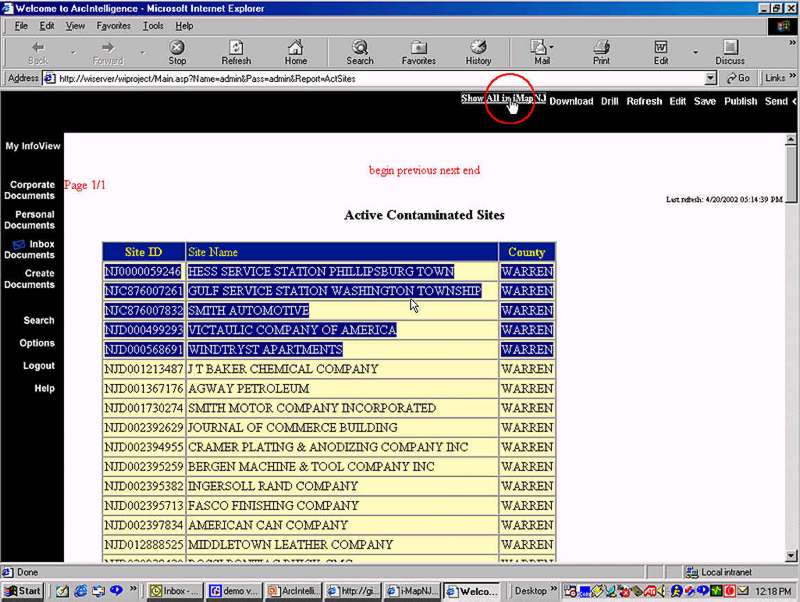
SQL is generated querying the available data and a new tabular document is created. Users can also graph their data in a variety of ways using the graphing and report writing toolbar above the table window.
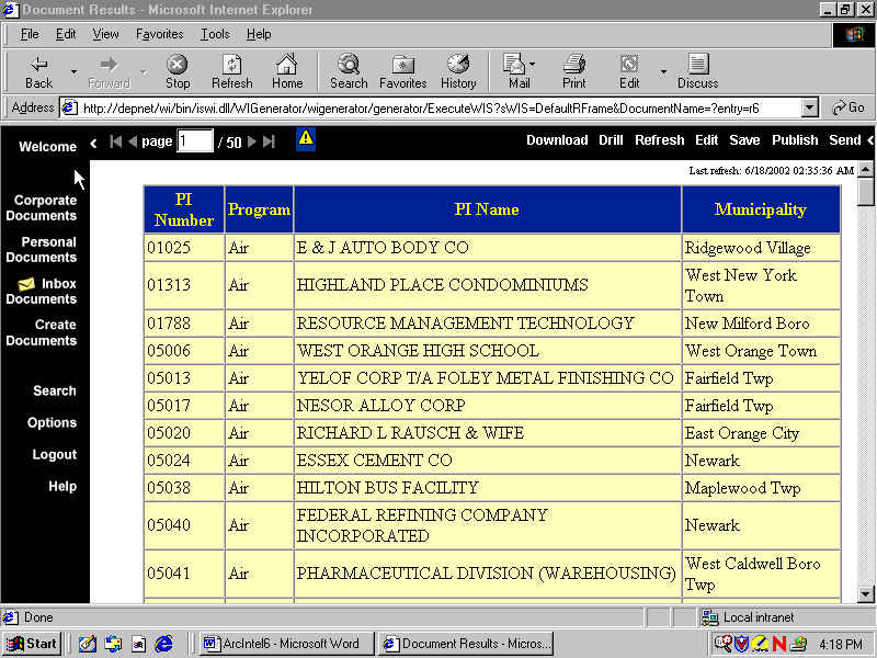
Figure 5 Ė WebIntelligence document results page.
The resulting table can then be downloaded into spreadsheet format, saved as a personal document or published as a corporate document.† The table can also be sent to another InfoVIEW user.
The primary enhancement of the core functionality in the new i-MapNJ 2.0 application is† the building of a dynamic, bi-directional data bridge between i-MapNJ and WebIntelligence components (see Figure 6). This bridge will allow data transfer between the i-MapNJ (spatial and query) environment and the WebIntelligence (query and report) environment, creating a very powerful integrated application, which BGIA has named ArcIntelligence.
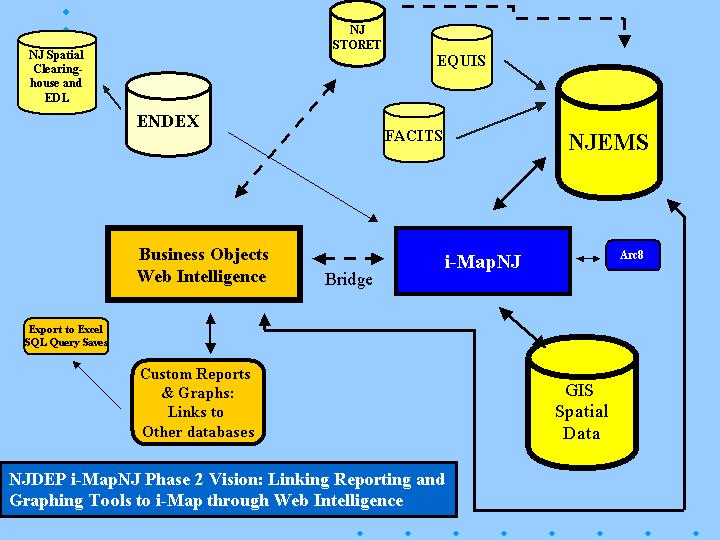
Figure 6 Ė Bridging i-MapNJ (ArcIMS) and WebIntelligence.
The new i-MapNJ 2.0 ArcIntelligence model shows the relationship between NJEMS, i-MapNJ (ArcIMS), WebIntelligence and ENDEX, NJDEPís intranet environmental data clearinghouse. Please note the area for building the bridge between WebIntelligence and i-MapNJ 2.0.
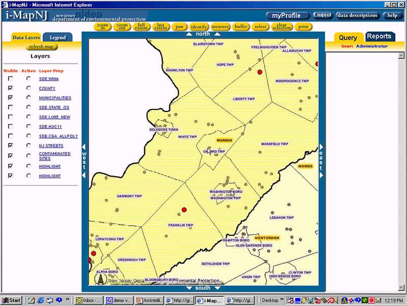
The query results from i-MapNJ include general tabular data associated with mapped features, including unique feature IDs.† The results derived from a query in WebIntelligence include the unique ID field that relates to the same unique ID field that exists in an ArcSDE GIS feature layer.† When bridging to i-MapNJ, the relationship between WebIntelligence derived tabular data and the ArcSDE GIS layer is established via the unique ID field.
Within i-MapNJ there are predefined queries that enable some basic NJDEP program related questions to be asked, while at the same time establishing a geographic area of interest (AOI).† The questions available to the user are determined by the userís i-MapNJ profile. †The program related questions are limited to identifying the source of data (NJEMS, NJSTORET, other ArcSDE layers), identifying the features of interest (site names, IDs, NJEMS Program Types, NJSTORET monitoring agencies, and projects), and identifying an AOI.†† Running these queries produces a selected set of features from an ArcSDE layer.† The selected featuresí unique IDs from this layer are passed to WebIntelligence to a default custom data universe, determined by the userís i-MapNJ profile.† The same unique IDs are present in the corresponding WebIntelligence data universe.
In WebIntelligence, the tabular data is associated with additional data or report documents. CyberTech Systems, Inc. is building two predefined reports for each program profile.† By enabling the association of additional data in WebIntelligence, more specific and refined data queries can be generated, greatly reducing the need for additional custom coding to support data queries in i-MapNJ.† Users are able to save the tabular data to new report documents, export the data to a spreadsheet for further analysis in an external application, or import the data back into i-MapNJ to view it spatially.
Based on discussions held with representatives from several NJDEP programs, BGIA was able to identify seven major i-MapNJ development initiatives for i-MapNJ 2.0- ArcIntelligence.† The proposals made by the programs are to provide web-based mapping capabilities that address needs for both Intranet and at a later date, Internet users.† These seven initiatives will, for the most part, correspond to user profiles that will be developed providing NJDEP staff customized versions of the application to suit different program needs. A brief overview of the major NJDEP program needs required for i-MapNJ 2.0-ArcIntelligence development is presented here.
Divisions of Watershed Management and Science, Research, and
Technology
The unique IDs for the withdrawal points will be passed into WebIntelligence, where they will be associated with additional data fields from NJEMS.†† The data will be sorted by NJEMS program interest and a report will be generated in WebIntelligence for exporting and printing.
A ďPrint NJEMS Program Interest Mailing AddressesĒ report will be developed in WebIntelligence that will enable users to generate mailing addresses for each Water Allocation program interest within the designated radius.
The Bureau of Safe Drinking Water needs i-MapNJ 2.0-ArcIntelliegence to display and provide tabular data for potential sources of contamination near a water system or more specifically, near a well or intake. Users will be able to search in i-MapNJ for wells, intakes, and treatment facilities by county and municipality.† They will also be able to perform a radial search from an entered coordinate, address, or currently selected map feature.
An ďIdentify my water systemĒ search will be developed, allowing users to locate their water system's service area and source area by entering either an ID number, a system name, municipality, address, or location coordinate. When found, i-MapNJ would then allow the user to display the complete water system, the purveyor service area, source water assessment areas, and wells and intakes associated with the water system.
Several very useful queries will be developed for NJDEP's Site Remediation Program.† A few of them are designed to first get the user to their particular area of interest. Then through instructions provided, enable them to do some simple visual analysis (turn on GIS layers) to assist in decision-making.† There will be one query that will assist public well drillers in placing wells outside of areas known to have contaminated groundwater.† Another will assist SRP staff in searching for possible sources of an environmental contaminant.† Another, targeted for use by the general public, is a search for potential contamination risks associated with a real estate purchase.† Another will be designed for SRP staff that will allow them to compare existing institutional controls (Classification Exception Areas, DERís (Declarations of Environmental Restriction), Known Extents of Contamination) with updated groundwater sampling data to check for continued protectiveness.†† The other more involved query is targeted toward NJDEP's Emergency Response group.† After entering a location (address, coordinate, point on map), the application would zoom to the area and highlight nearby receptors (waterbodies, wetlands, wells, intakes, etc.) that could be at risk from a surface contaminant spill.
To enable NJDEP staff and others to access data layers and reports relevant to their needs ArcIntelligence User Profiles present them with a customized environment based on their NJDEP program affiliation.† There also is access to a default user profile for those logging on who do not belong to one of the NJDEP Programs listed. Default users are presented with a generalized interface.† The user ID and password determine what profile is initially accessed.† Users will not have to logon twice when switching between i-MapNJ and WebIntelligence.† Each Profile defines the set of GIS data layers, predefined queries, reports, toolbar tools as well as the WebIntelligence universe that the user views.† Individual users can further customize their interface accessing a list of other GIS data layers, reports and queries or another NJDEP programís profile.† This can then be saved as a a personalized ArcIntelligence profile for later use.†
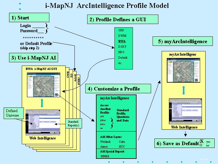
When a users first enters i-MapNJ 2.0 ArcIntelligence they will be asked to log in with their user name and password.† This will determine which i-MapNJ interface they will initially see as well as the WebIntelligence universe, they will initially access.† As mentioned earlier, this can then be customized to a users preference, but initially users will be presented with the GIS layers, screen interface and WebIntelligence universes they would likely want to access based on NJDEP program affiliation.
:
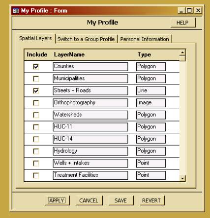
When a user presses the ĎMy Profileí button, a tabbed form appears (See Figure 9).† The first tab, ďSpatial LayersĒ, is used to add and/or remove spatial layers from the desktop display. The layers currently loaded for the user will have a checkmark next to them. To remove one of these layers, the user needs to remove the checkmark next to the layer name by clicking on the checkbox. To add a layer, the user needs to put a checkmark next to the layer name.
The layers are listed on this screen in the order of their internal ĎLayer IDí. This is an identifier in the Layers table in the User Profiles module that can be given any unique value. This ID can be used to group Layers in categories so that related ones will appear together on this screen. This will help users locate the desired layers.
Layers are added to the desktop in an automatic order: images first, then polygons, then lines, and finally points. This order will help prevent one layer from covering up another layer when they are made visible.
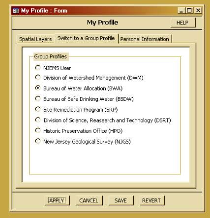
Figure 10 Ė My Profile Switch a Group Profile form enables users to view another programís user profile.
If the user clicks on the ďSwitch to
a Group ProfileĒ tab, the group profiles options appear (See Figure 10).† This
screen enables the user to switch to another Program Officeís default Profile.
This will set up the userís desktop display to those spatial layers, queries
and reports that come with a Program Officeís default Profile. Switching to
another Profile changes the layers available for adding and removing.
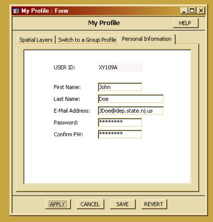
Figure 11 Ė My Profile personal information form
The ďPersonal InformationĒ tab is used to view and/or edit a userís personal information (See Figure 11).† It is envisioned that this tab may access the ĎMy New Jerseyí Portal rather than being a separate screen that is part of i-MapNJ. The screen above gives an example of the kind of data that can be captured for a user. Using the Portal will enable the system to store a userís information in a single place. This will accommodate Ďsingle sign oní for the Portal, i-MapNJ and WebIntelligence. In this case, the format of this screen and the information available for viewing and editing will be provided by the Portal.
NJDEP hopes to have the i-MapNJ 2.0 Ė ArcIntelligence application completed by late summer 2002.† With its custom user profiles and integration with WebIntelligence, NJDEP will be able to deliver a very useful and powerful Intranet application to any user in the department.† The integration with WebIntelligence allows users to develop their own custom queries of the data.† Users are not limited to hard-coded queries.†
It is anticipated that additional programs in the agency will be added as new profiles in the future, with customized queries and reports.† Indeed, the stateís Chief Information Officer has recommended other New Jersey agencies adopt NJDEPís ArcIntelligence model for serving maps and data over the web.† While the application will not replace ArcInfo and ArcView as the GIS applications for the Departmentís planning and decision-making, it will provide a very useful, easy to use tool that can assist in the process.
NJDEP plans to go to work on making an Internet version of the application in the fall of 2002.† Several issues will need to be considered, including possible migrating to ArcIMS version 4.0, creating custom profiles for public access and the regulated community.† Metadata for all GIS layers will need to be completed and information in associated tables in Oracle will need to be documented.† User help information will need to be thorough and easy to understand.† It is difficult to know how the general public and regulated community will react to the application.† Feedback from the outside may help determine what further development work is done for the Internet version.
The authors would like to thank members of NJDEP, BGIA staff involved in the development of i-MapNJ: Marla Chassels, Diane Johnson, Dnyanada Bhide, John Fleming and John Tyrawski and also Mike Matsko of NJDEP, Office of Information Resource Management (OIRM) for his assistance with the Business Objects section.† The authors would also like to thank the staff of Cybertech Systems Inc. for their technical assistance in the writing of this paper: Bob Sparks, Carol Meade, Mahalakshmi Ravi, Anand Chikkala, Ramakrishna Nettyam and† Ravichandran Jyoti.† Special thanks to Marla Chassels of BGIA for her help editing this paper.
The New Jersey Department of Environmental Protection, Bureau of Geographic Information Analysis (GIS) program website is located at: www.state.nj.us/dep/gis
Lawrence L. Thornton, Manager GIS Unit, New Jersey Department of Environmental Protection, PO Box 428, 401 East State Street, Trenton, NJ, 08625-0428; (609)633-8144(V); (609)292-7900(F); Larry.Thornton@dep.state.nj.us.
Lou Jacoby, GIS Specialist I, New Jersey Department of Environmental Protection, PO Box 428, 401 East State Street, Trenton, NJ, 08625-0428; (609)633-1203(V); (609)292-7900(F); Lou.Jacoby@dep.state.nj.us
Tim Huizing, GIS Specialist II, New Jersey Department of Environmental Protection, PO Box 428, 401 East State Street, Trenton, NJ, 08625-0428; (609)633-1262(V); (609)292-7900(F); Tim.Huizing@dep.state.nj.us.