Locating and quantifying patient population distributions is the first step in planning effective telemedicine systems. The model presented determines spatial relationships among patient locations in the Gulf of Mexico and land-based tertiary health care facilities. The telemedicine system provides immediate access to emergency health care and minimizes unnecessary and costly MEDEVAC�s (medical evacuations). The approach employs ArcView software to identify potential telemedicine hub sites in the Gulf of Mexico relative to patient populations engaged in high-risk occupations.
To develop a hypothetical model for identifying potential locations of offshore telemedicine satellite hub sites as part of the needs assessment phase of planning telemedicine services for the Gulf of Mexico.
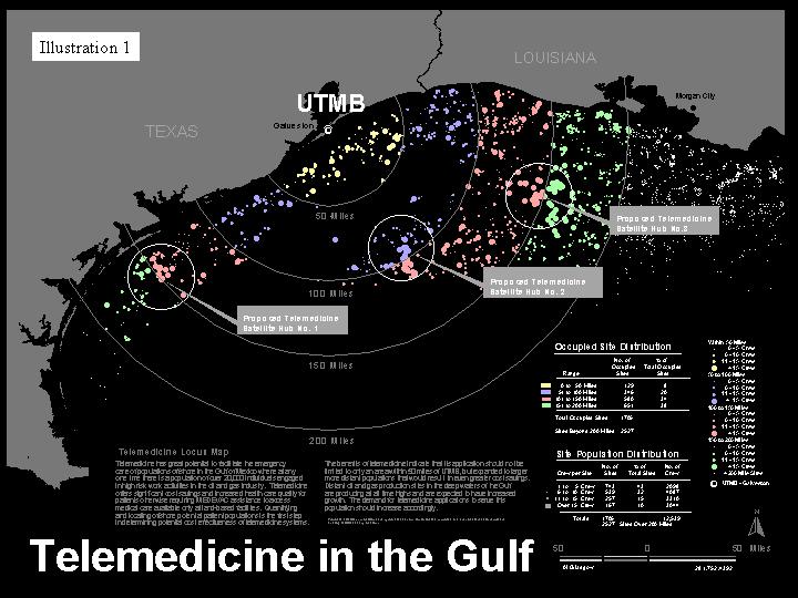
A three-step strategy was employed to collect and analyze large amounts of patient population data and to effectively communicate findings. First, parameters for the subject patient population data set were established. This was accomplished by assigning random crew sizes to existing sites in the study area. Second, a scheme of graphic features depicting crew size (scale) and distance (color) from University of Texas Medical Branch located in Galveston, TX (UTMB) was applied to the data set. Third, identification of population concentrations was accomplished by observing massing patterns of crew populations.
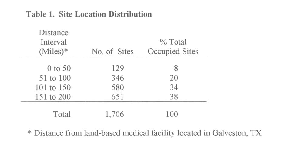
There were two eligible criteria for inclusion of a patient site in this analysis. The patient location needed to be within a 200-mile radius of UTMB and be located in the waters of the Gulf of Mexico. Also, sites had to be represented by an existing structure (not removed) and be occupied by individuals. Once the subject population was defined, attributes of crew sizes (size of circle) and site proximity to UTMB (color) were employed to visually indicate site population magnitude and distance from UTMB.
Systematic electronic database searches were conducted using Internet search engines to identify appropriate GIS (Geographic Information System) databases to locate worker sites. U.S. government as well as commercial databases were reviewed. The U.S. Department of the Interior Minerals Management Service�s (MMS) Gulf of Mexico Region File1 in ArcInfo format was selected for its extensive scope of records, attributes and availability.
Records from the MMS database were queried to extract eligible patient locations for further study. Sequential queries on the database were conducted to determine the distribution of sites within 50-mile intervals within 200 miles of UTMB. Further analysis was undertaken to confirm platform existence or removal. Assumptions were made regarding crew sizes at specific sites.
A total of 5,944 records identifying platform locations were discovered for the entire Gulf as of May 14, 1999. Of these, 4,233 platforms existed and 1,711 had been removed. There were 1,706 existing sites within the 200-mile defined study area and are shown as solid colored circle features within color-coded 50-mile bands radiating from UTMB as shown in Illustration 1. Approximately 72% of total sites were located between 101 and 200 miles from UTMB.
Existing platform locations within the 200-mile study area are geographically distributed as shown in Table 1. Another 2,527 sites were found to exist in the Gulf of Mexico beyond the 200-mile study area and indicate that the study area included only an approximate 40% of the total number of sites in the Gulf.
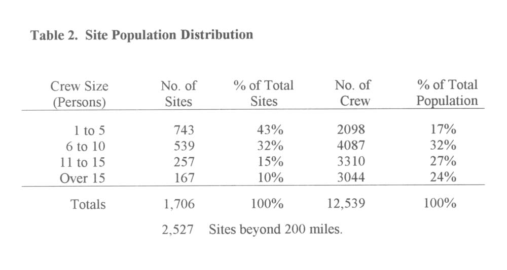
There were 12,539 total crewmembers within the study area. Site crew size is represented via a scheme of a four-step scale of colored solid circles (smallest representing smallest crew size). Of the 1,706 total existing sites, 76% have crew sizes less than 11 individuals. By viewing the ArcView layout it can be easily seen that the patient population is characterized as being distant (beyond 100 miles) and widely dispersed. Population distribution within the 200-mile study area is shown in Table 2.
Assuming an equal probability of need for telemedicine services at all sites, geographical areas with concentrations of the highest numbers of crewmembers should be considered as optimal locations for telemedicine satellite hubs. By graphically representing population attributes, a visual pattern of population density and concentration can be seen. Three areas were located within or proximate to the 101 to 150-mile band of sites. Three general areas were identified as having clusters of sites with the greatest concentration of potential patients as shown in Illustration 1.
According to the MMS, oil and gas production in the deep waters of the Gulf of Mexico reached an all time high in 1998 and continues to grow. In 1998, oil production in Gulf of Mexico waters more than 1000 feet deep rose 47%. Gas production also increased 47%. These increases were a direct result of recent projects in more distant deeper water over the last five years. Over this period deep water oil production has risen 279% and gas production has risen 252%.
As oil and gas activity continues at existing production sites and as the number of more distant sites continues to increase, thereby increasing the offshore population, demand for telemedicine applications and associated cost savings and health care benefits will increase accordingly.
Locating and quantifying patient populations is the first step in planning effective telemedicine systems that provide immediate access to emergency health care and minimize unnecessary and costly MEDEVAC�s. This model establishes an approach for the collection, analysis, summary and graphic communication of very large amounts of quantitative data on patient population attributes for widely distributed service areas.
GIS can be utilized to quickly quantify cost savings and visualize areas that offer the greatest potential as locations for telemedicine hub sites. The model can be applied to any number of sites within or beyond the subject study area.
Kim Dunn, MD, PhD. Department of Health Informatics, School of Health Information sciences, Health Science Center at Houston, University of Texas, Houston, TX.
Osborne Nye, PhD. Department of Geographic Information Science, Houston Community College, Houston, TX.
Fradosht Armirphanihi. Department of Geographic Information Science, Houston Community College, Houston, TX
Anna Zachos. School of Public Health, University of Texas, Houston, TX
1. U.S. Department of the Interior, Mineral Management Services. Geographic Mapping Data. May 14, 1999.