|
Paper 172 -- Twenty-second Annual Esri International User Conference, San Diego, CA, July 8-12, 2002
Abstract
The U.S. Environmental Protection Agency (EPA) Office of Ground Water and Drinking Water is developing a Web-based geographic information systems (GIS) application to support Safe Drinking Water Act programs. The goals of this development effort include identifying contaminant risks for drinking water intakes or groundwater wellheads and documenting how states are setting up source water protection areas. A prototype application is described that combines the Environmental Systems Research Institute (Esri) ArcIMS map server with data servers that host attributes from a range of state-derived and major national information sources, including EPA's Safe Drinking Water Information System. Proximity analysis techniques are highlighted that illustrate ways that Esri's new map server and geodatabase technologies facilitate the creation of tools that provide Web-accessible GIS functionality.
Background and Purpose
The U.S. Environmental Protection Agency (EPA) Office of Ground Water and Drinking Water (OGWDW) is developing a state-of-the-art, Web-based mapping and database technology to enhance EPA's ability to identify major contaminant risks to public drinking water supplies. A major focus in this drinking water geospatial application is the analysis of information related to provisions in the 1996 Safe Drinking Water Act (SDWA) amendments, which require states to develop source water assessment and protection (SWAP) programs. OGWDW aims to identify core information components in these state SWAP programs and to evaluate technical approaches to compile these core state mapping and database products using consistent national formats. EPA is not only to defining efficient ways to take advantage of final state SWAP materials (which will become available beginning in early spring 2003); it is also working to enhance the value of information from SDWA programs and other national-level geographic information systems (GIS) layers and data sets as components in geospatial applications.
The OGWDW promotes the state use of the Safe Drinking Water Information System (SDWIS/State). Summary information from SDWIS/State or other state data systems is compiled in the federal system, known as SDWIS/Fed. The new OGWDW geospatial application will incorporate a variety of tools that help present and map information in SDWIS/Fed, including information on the occurrence of contaminants involving SDWA standards [e.g., Maximum Contaminant Level (MCL) criteria for chemicals such as benzene and standards for physical indicators such as turbidity]. SDWIS/Fed can also provide information on the population served by a facility and on the local administrative units (e.g., counties) associated with a water supplier. The OGWDW is working to develop GIS data layers to map the locations of surface drinking water intakes using the U.S. Geological Survey (USGS) National Hydrography Data Set (NHD). These locations are placed in EPA's Reach Address Database (RAD), a geodatabase that provides a common infrastructure for use in the OGWDW's Web-based application. The RAD also provides a standard source for a variety of other useful GIS layers and data sets drawn from a range of EPA programs [e.g., the NHD itself, Clean Water Act Section 303(d) Total Maximum Daily Loads (TMDLs)] and helpful navigation layers (taken from such new EPA systems as the Integrated Geodatabase) that include county boundaries, watershed polygons, or major roads. Much of this information is publicly accessible through the Office of Water's (OW's) EnviroMapper (see http://www.epa.gov/waters/).
The OGWDW application also seeks to effectively use information in the EPA data warehouse system known as EnviroFacts (see http://www.epa.gov/enviro/index_java.html). EnviroFacts is a gateway to several EnviroMapper-style applications (e.g, the EnviroMapper for Superfund). It also provides sets of Web-based forms that allow use to provide inputs and then generate a variety of custom data table displays. The OGWDW has developed several data table query tools in EnviroFacts to help show the occurrence of contaminants related to existing drinking water regulations or contaminants under consideration for criteria review or the development of new regulations. Where new data collections are targeted to steer the development of new drinking water criteria for chemical or microbial contaminants, EPA coordinates initiatives to assemble special information collection rule (ICR) data sets. Several of these special ICR data sets are now publicly available through EnviroFacts (see http://www.epa.gov/enviro/html/icr/index.html).
Clearly, there is a wealth of database and GIS materials available. The aim of OGWDW's Web-based application is to identify high-priority content and feature capabilities to support data query and mapping needs for major OGWDW programs.
Organization of the HTML Browser User Interface
User requirement surveys of EPA staff in the OGWDW documented interest in
an application- driven technical approach that would combine the functionality
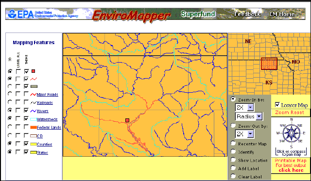
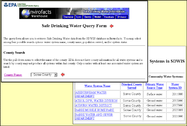
of existing Web-based "mapper" applications (e.g., the Office of Water
EnviroMapper for Superfund as illustrated in Figure 1) and applications that
only provide tabular displays based on queries against relational databases
(e.g., the EnviroFacts query application illustrated in Figure 2). Focus
group techniques were used to document user requirements deemed by OGWDW
staff as being of the highest priority. During the initial phase of application
development, inputs were obtained from members of OGWDW's Drinking Water
Protection Division. During 2002, user priorities have been reevaluated within
this division, and the survey process has been expanded to the OGWDW Standards
and Risk Management Division. The aim is to document the high-priority
application needs for all the branches in both divisions of OGWDW.
|
|
 |
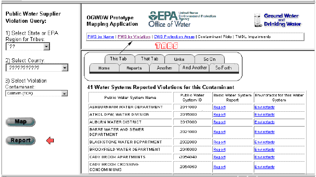
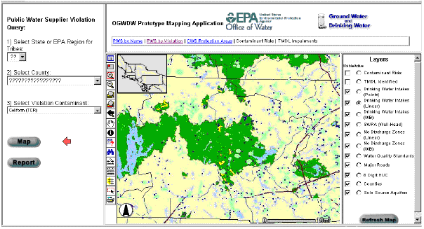
The application's user interface is constructed with the assumption that EPA staff will generally want to perform a query against one or more databases to generate a tabular report. The application then uses the information from this custom query to produce a GIS vicinity map based on key information attributes from the report. Several types of reports are required to serve the needs of the different programs within the OGWDW. To meet this need, a set of tabs in a special-use interface window allows the selection of different query forms. Figure 3 illustrates the integration of the tabs and query forms used to generate a tabular report. Figure 4 shows a GIS vicinity map based on information generated from a query. In these examples, the tabular and mapping outputs reflect the selection of a tab (in the topmost frame) related to violations of national drinking water standards as reported in EPA's SDWIS/Federal data system. The query forms (in the in frame to the left) for this tab require the user to specify a particular state and county as well as a contaminant of interest (in this case, information on total coliform rule exceedances). Once these inputs are provided, the user can select output in the form of a data table or a vicinity map bounding the geographic unit of interest. Starting from the geographical extent of the initial mapping display, the user can apply a variety of GIS functions to zoom in or out, activate or deactivate features, or apply other ArcIMS GIS tools. For security reasons, these figures have been edited to suppress the state and county inputs used in the report and GIS map.
 |
 |
Application Design Features
The prototype application is multitiered, meaning that it uses software running on the client desktop computer, Web servers, and database servers. The application requires the client machine to be attached to the Internet (or an intranet) and to support a standard Web browser. To comply with EPA computer infrastructure standards, the application uses two Web servers, one running Microsoft Internet Information Server (IIS) and a separate server running the Oracle Application Server (OAS). The database server must support OAS version 4.0.8 and Oracle 8i.
The prototype application was developed using frames, OAS, and the ArcIMS HTML viewer to leverage the powerful functionality available "out of the box" for this type of ArcIMS application. The application currently requires client-side communication between the query frames based on OAS and the mapping frames based on ArcIMS. Currently, query information is posted by OAS to an intermediary frame on the ArcIMS server (currently IIS), and Active Server Pages (ASP) are used to transfer this query information to ArcIMS. Since the preferred configurations in the EPA central server environment may change, a variety of alternative query information transfer methods are being explored. In particular, the migration of database query routines from Oracle PL/SQL to ASP could simplify client-side communication by eliminating the need for the OAS server.
Two major considerations guided the application design. First, the application leverages the existing HTML viewer functionality to the maximum possible extent to minimize development time and costs. Second, the application aims to make maximum use of the existing EPA central server environment architecture, which has a strong preference for using OAS rather than ASP to serve Oracle database data. ASP connectors are applied primarily to allow communication between the frames used to organize the HTML user interface. Other customizations enable the application to perform queries and highlight result sets composed of multiple data layers (e.g., where drinking water intakes may involve both linear and polygon surface water features). To maximize system throughput, spatial database engine (SDE) geodatabase approaches will be increasingly utilized to access information from such core EPA systems as the RAD. The main features of the prototype application design are illustrated in Figure 5.
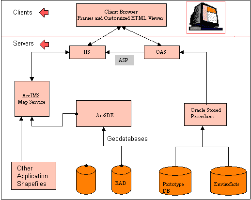 |
In the initial prototype implementation, OAS and IIS serve the static and dynamic HTML. ArcIMS handles and provides tools for most of the server- and database-level tasks required to serve and interact with geographic data over the Web. The ArcIMS software can be installed and configured in many ways. The simplest installation puts all of the ArcIMS components on a single machine. However, different components can be spread among multiple machines to increase performance, if desired. Machine configurations used by EPA for its own production and development systems are considered carefully in the installation of ArcIMS and its connection requirements with other network components.
The application does not require anything extra to be installed on the client (i.e., the end user will not have to install anything on his or her desktop computer). The only software requirements for the end user are a supported browser version and compatible browser security settings. At the present time, the supported browsers include Internet Explorer version 5.0 (or a more recent version of the Internet Explorer browser) and Netscape Communicator (including versions 4.75, 4.76, or 6.0).
The ArcIMS Web server is currently Microsoft IIS. Other candidate Web servers include Netscape and Apache. Because ASP components are used to communicate between OAS and IIS, non-IIS Web servers would need to be made compatible with ASP (e.g., through additional components). The GIS data server can be geodatabases (e.g., ArcSDE) or shapefiles stored locally to the ArcIMS application server. The software for ArcSDE is installed in conjunction with a relational database management system. The initial application prototype was built using shapefiles, but GIS materials will increasingly be accessed from standard EPA geodatabases. The application currently accesses standard EPA Office of Water geodatabase systems such as the RAD (Plastino 2000), as well as other EPA core geodatabase systems and special database and spatial feature holdings.
Users of this application will require access to the Internet (or an intranet). The HTML viewer model (a Web-based GIS viewer implemented using client-side Javascript) requires the least communication between the client and the server. An alternative ASP connector implementation for the GIS viewer is currently under consideration; it would further reduce the amount of data transferred between the client and the server, because a larger amount of the computing load would be moved back to the server. However, the ASP connector implementation would require substantial additional customization of the mapping application. The drawbacks and benefits of this approach are being evaluated.
The Application Defined in Terms of Target Audience, Data, and Security Considerations
EPA's Office of Water is working with the Office of Environmental Information and other EPA geospatial teams to develop an impressive set of core geospatial data systems and tools. Geodatabases such as the RAD provide a convenient infrastructure to facilitate the creation of a broad range of Web-based applications (Plastino 2000). Applications will differ depending on the target audience, the data components required to address client business needs, and security issues.
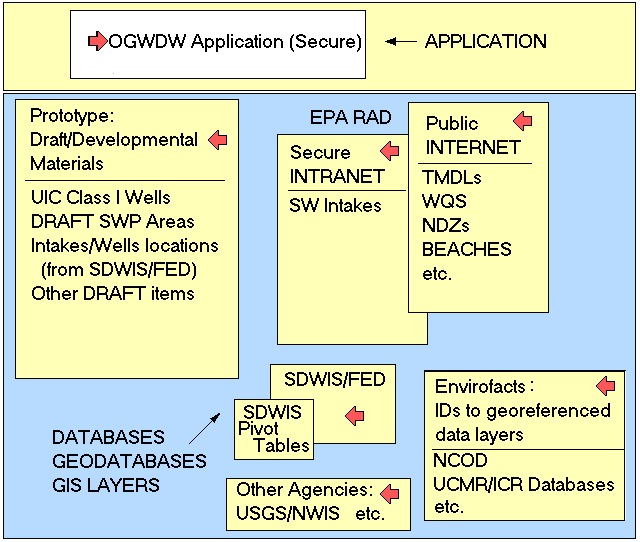
The EnviroMapper for the Office of Water, Window to My Environment, and the EnviroMapper for EnviroFacts are systems that address the needs of public audiences. These applications can operate as public (nonsecure) Internet services and tap public infrastructure components in such geodatabases as the RAD or EPA's Locational Reference Tables system. For situations in which data components are of a draft nature, information is intended for specialized audiences, or some of the information involves sensitive data, an application can be created to operate on a secure Agency Intranet system.
The OGWDW application is an example of a secure system with a focused target audience: staff members in the divisions and branches of the OGWDW. In addition to employing EPA infrastructure data components, the OGWDW application also employs special draft or developmental information, such as draft materials detailing states' source water protection programs. Over time, the goal would be to move these draft materials into EPA infrastructure geodatabases. The OGWDW application also aims to tap major national-level data items from other federal agencies such as the USGS. As with internal EPA data, some USGS items are public, but many USGS information components may involve security issues. The diagram in Figure 6 illustrates the data and security arrangements that define the appropriate data system niche for the OGWDW application.
 |
The Application Defined in Terms of Underlying Environmental
Systems
A widely accepted system for minimizing human health risks from drinking water contaminants is the multibarrier approach (Wolman 1969). This concept emphasizes appropriate levels of treatment for raw surface-water and groundwater supplies and checks on the quality in the distribution systems that carry treated water to end users. The multibarrier approach also encourages measures to protect the quality of source water supplies. A well-balanced multibarrier strategy requires careful coordination between drinking water programs and other established water resource programs charged with the management of point source and nonpoint source pollution.
In the 1996 reauthorization of the SDWA, the critical role of source water protection was elevated to a required feature for all public water systems in the United States (US EPA 1997a). Each state was required to develop source water protection programs for both surface-water and groundwater resources used by public drinking water utilities. Previously, water treatment had been the focus of most drinking water programs. Instead of requiring broadly based and proactive steps to protect source water quality, these programs usually encouraged drinking water utilities to select deeper aquifers or focus only on protecting small watersheds where ordinary land uses could be excluded. These strategies have been remarkably successful, but not all watersheds can be exclusively zoned for drinking water purposes and not all aquifers can be viewed as immune to pollution vulnerability. Finally, even sophisticated water treatment technologies may be taxed to eliminate all risks from pathogens and for contaminants such as nitrates and atrazine, where conventional treatment methods are not highly efficient. In many areas, therefore, attention to improved source water management is worth serious consideration.
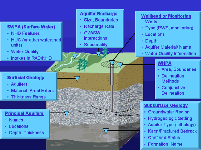
EPA applications that build on the RAD and the USGS NHD are facilitating the construction of Web-based applications dealing with surface water (Plastino 2000). But since the majority of public water supplies partly or fully rely on groundwater, a major challenge for the OGWDW application is to do justice to the three-dimensional nature of the groundwater resource. The simplified block diagram in Figure 7 highlights the major components of the complete surface water and groundwater environmental system where select data and GIS materials are needed to fully implement the OGWDW application. Clearly, the major challenge is to encourage the development of what can be called an NHD for groundwater. EPA's OGWDW, other EPA programs, and partners in other agencies such as the USGS are taking steps to make this concept a reality. As new building blocks for this three-dimensional geodatabase become available, they will incorporated into queries and mapping features for the OGWDW Web-based system.
|
Future Directions
The OGWDW application started with a focus on available information that was drawn largely from a handful of northeastern states. Presently, work is underway to add state-derived information for additional states, rounding out the coverage for the northeast but also including information from states in the Midwest and the Far West. Final versions of these data items will not generally be completed until sometime in 2003; this presents a complication with using available state source water protection information. There are also a number of security issues in accessing the state-derived information. These considerations encourage a shift in the short-term development focus toward creating a range of national-level databases and GIS layers. This effort will provide basic framework materials for the entire country so that the application prototype can become at least partially operational as soon as possible.
Acknowledgments
The work described in this paper was funded by the U.S. Environmental Protection Agency under Contract 68-C-01-007 with Research Triangle Institute (RTI). RTI gratefully acknowledges this support.
Disclaimer: Although the research described has been funded wholly or in part by the U.S. Environmental Protection Agency Contract 68-C-01-007 to Research Triangle Institute, it has not been subject to the Agency's review and therefore does not necessarily reflect the views of the Agency, and no official endorsement should be inferred. Mention of trade names or commercial products does not constitute endorsement or recommendation for use.
References and Bibliography
Aller, L., T. Bennett, J.H. Lehr, R.J. Petty, and G. Hackett. 1987.
DRASTIC: A Standardized System for Evaluating Ground Water Pollution
Potential Using Hydrogeologic Settings. EPA-600/2-87-035. Ada, OK: U.S.
Environmental Protection Agency, Robert S. Kerr Environmental Research
Laboratory, Office of Research and Development.
Clawges, R.M., and C.V. Price. 1999. Productive Aquifers of the Conterminous
United States. Version 99-77. Rapid City, SD: U.S. Geological Survey.
Davies, W.E., J.H. Simpson, G.C. Ohlmacher, W.S. Kirk, and E.G. Newton. 1984.
Engineering Aspects of Karst. Reston, VA: U.S. Geological Survey.
Heath, R.C. 1984. Ground Water Regions of the United States.
Water-Supply Paper 2242. Washington, DC: U.S. Geological Survey.
Miller, J.A. 1998. Principal Aquifers of the 48 Contiguous United
States. Version 1.0. Madison, WI: U.S. Geological Survey.
Newell, C.J., L.P. Hopkins, and P.B. Bedient. 1990. A Hydrogeologic Database
for Ground Water Modeling. Ground Water 28(5):703-714.
Plastino, Michael. 2000. EPA Office of Water Georeferencing Plan: Toward
a More Integrated EPA Information Framework. 20th Annual Esri International
User Conference in San Diego, California. (Internet Address:
http://gis.Esri.com/library/userconf/proc00/professional/professional_content.html).
U.S. EPA (Environmental Protection Agency). 1987a. Sole Source Aquifer
Designation: Petitioner Guidance. 440/6-87-003. Washington, DC: U.S.
Environmental Protection Agency, Office of Ground Water and Drinking Water.
February.
U.S. EPA (Environmental Protection Agency). 1987b. Guidelines for Delineation
of Wellhead Protection Areas. 440/6-87-010. Washington, DC: U.S.
Environmental Protection Agency, Office of Ground Water and Drinking Water.
June.
U.S. EPA (Environmental Protection Agency). 1991a. Wellhead Protection
Strategies for Confined Aquifer Settings. 570/9-91-008. Washington,
DC: U.S. Environmental Protection Agency, Office of Ground Water and Drinking
Water. June.
U.S. EPA (Environmental Protection Agency). 1991b. Delineation of Wellhead
Protection Areas in Fractured Rocks. 570/9-91-009. Washington, DC: U.S.
Environmental Protection Agency, Office of Ground Water and Drinking Water.
June.
U.S. EPA (Environmental Protection Agency). 1993a. Wellhead Protection
in Confined, Semi-Confined, Fractured, and Karst Aquifer Settings.
813/K-93-001. Washington, DC: U.S. Environmental Protection Agency, Office
of Ground Water and Drinking Water. September.
U.S. EPA (Environmental Protection Agency). 1993b. Wellhead Protection:
A Guide for Small Communities. EPA/625/R-93/002. Washington, DC: U.
S. Environmental Protection Agency, Office of Research and Development and
Office of Water.
U.S. EPA (Environmental Protection Agency). 1994. Class V Injection Wells
and Your Drinking Water. 813/F-94-005. Washington, DC: U.S. Environmental
Protection Agency, Office of Research and Development and Office of Water.
July.
U.S. EPA (Environmental Protection Agency). 1995. Tribal Wellhead Protection
Demonstration Projects. 813/R-95-001. Washington, DC: U.S. Environmental
Protection Agency, Office of Ground Water and Drinking Water. July.
U.S. EPA (Environmental Protection Agency). 1997a. State Source Water
Assessment And Protection Programs: Final Guidance. EPA-816-R-97-009.
Washington, DC: U.S. Environmental Protection Agency, Office of Ground Water
and Drinking Water.
U.S. EPA (Environmental Protection Agency). 1997b. Summary of State Biennial
Reports of Wellhead Protection Program Progress (As Required by Section 1428(g)
of the SDWA Amendments of 1986) October 1995 through September 1997.
Washington, DC: U.S. Environmental Protection Agency, Office of Ground Water
and Drinking Water (Internet address:
http://www.epa.gov/safewater/protect/gwr/biennial.html).
U.S. EPA (Environmental Protection Agency). 1999a. Safe Drinking Water
Act, Section 1429: Ground Water Report to Congress. 816/R-99-016.
Washington, DC: U.S. Environmental Protection Agency, Office of Ground Water
and Drinking Water. December.
U.S. EPA (Environmental Protection Agency). 1999b. Class V Injection
Wells: U.S. Environmental Protection Agency Announces New Regulatory Requirements
for Certain Class V Injection Wells. 816/F-99-016. Washington, DC:
U.S. Environmental Protection Agency, Office of Ground Water and Drinking
Water. December.
U.S. EPA (Environmental Protection Agency). 2001. Class I Underground
Injection Control Program: Study of Risks Associated with Class I Underground
Injection Wells. 816-R-01-007. Washington, DC: U.S. Environmental Protection
Agency, Office of Ground Water and Drinking Water. March.
Wolman, Abel. 1969. Water, Health and Society: Selected Papers by Abel Wolman. Edited by Gilbert F. White. Bloomington, IN: Indiana University Press.
William S. Cooter, Ph.D. (To whom inquiries should be directed)
Research Environmental Scientist, sid@rti.org
RTI, P. O. Box 12194, Research Triangle Park, NC 27709-2194
Phone: 919-990-8694
James Sinnott
Programmer and Hydrologist, jsinnott@rti.org
RTI, P. O. Box 12194, Research Triangle Park, NC 27709-2194
Phone: 919-990-8622
Michael Lowry
Geohydrologist and Web Application Designer, mlowry@rti.org
RTI, P. O. Box 12194, Research Triangle Park, NC 27709-2194
Phone: 919-541-7358
Jennifer Lloyd
Programmer and Database Administrator, jml@rti.org
RTI, P. O. Box 12194, Research Triangle Park, NC 27709-2194
Phone: 919-541-5942
Elizabeth Sullivan, esullivan@rti.org
Environmental Scientist and GIS Analyst
RTI, P. O. Box 12194, Research Triangle Park, NC 27709-2194
Phone: 919-990-8627
Roger Anzzolin
Project Manager for GIS Development, anzzolin.roger@epamail.epa.gov
U.S. Environmental Protection Agency, Washington, DC
Phone: 202-564-4093