| Using GIS to Help Government Executives and Citizens Make Great Decisions | ||
|
Edwin Gaskin
Raymond Freeland
Abstract
With the advent of web-based GIS applications, government executives are asking for GIS tools to aid in critical decisions. The objective of a GIS should be that executives use GIS without drawing inaccurate conclusions or having frustrating experiences. A well-designed GIS application will lessen the workload on GIS staff by lessening the requests for information from an executive level. The City of Richmond WebMapper ArcIMS application will provide the tools necessary to aid in the decision making process. 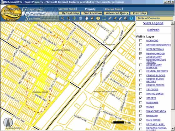
City of Richmond WebMapper
WebMapper’s Role within Richmond City Government
Background
The City of Richmond has suffered from removal of over 1,000 City employees since the mid 1980’s and has lost 1/5 of its total citizen population over that same period of time. To compound the City’s situation, it is estimated that 19.5% of the City population lives below the poverty line. Both the loss of population and economic hardships has resulted in fewer tax revenues for the City Government. While dwindling tax revenues and shrinking employee population have occurred, the remaining employee work force is still responsible for providing the same services to the public, but with fewer resources. Obviously, the demands placed upon the City of Richmond staff continue to be stretched to the limit.
Richmond has created a digital model of the City of Richmond. This model is currently used by a number of staff in departments such as Community Development, Economic Development, Public Works, Public Utilities, Information Technology and the GIS Work Group. GIS has succeeded in improving employee work flow processes and for improving planning and decision making by management.
New Role
In order to use GIS, however, staff was required to learn GIS software and related computer skills, while still having to perform all the duties required of their position. In addition to the steep learning curve, these employees’ departments would need to purchase expensive GIS software and often times, upgrade the computer hardware. It was discovered early on, that training staff to use GIS was not as successful as it was hoped. It was also expensive, due to software and hardware requirements of GIS desktop solutions. Approximately 80% of the City staff members who participated in the GIS Team’s GIS class abandoned or gave-up learning to use GIS. The reason for this is varied. Some folks felt overwhelmed, did not have the basic computer skills, or were in reality too busy to learn to use GIS software. The City’s GIS Team, however, wanted to get more folks involved in the use of GIS. It was necessary to develop an application that was robust enough to allow some advanced GIS analyses, but also easy enough to use for simple information retrieval and mapping. The WebMapper was conceived to address the needs of the 80% of City staff who should benefit from GIS capabilities, but are not GIS enabled or capable. An advanced GIS tool for the internet would be the only cost-effective way to make GIS accessible to the masses. Many of the City staff have positions that require extensive research of property-based information. Prior to GIS, all property and related information has only existed in legacy transactional databases or more often, in hardcopy format. It was virtually impossible for staff to gain access to information in any short time span. Everyday people from City Council, the Planning Commission, Office of the Assessor, Community Development, Office of Zoning and Permitting, Public Works, the Real Estate Office, and Economic Development (among others) have basic questions about specific properties or areas of the City. Previously, staff could spend entire days tracking down the type of information that is now available through the new GIS WebMapper. Because the GIS Team has developed a mature Geodatabase model, it is now possible to make that data accessible to answer property-based questions through the use of the WebMapper. The WebMapper is going to improve response times for researching information related to property location, saving staff time from previously cumbersome “running around” to locate information. It is anticipated that GIS is capable of helping to conserve many hundreds of hours of staff time. In addition to conserving staff time and resources, it is expected that customer service improvements will be realized. Previously, staff spent much time answering phone calls from both internal and external customers, but was unable to provide quick answers to questions. With the WebMapper, citizens will be able to find information themselves, or staff in the call center can gain access to information very quickly. The costs associated with developing the WebMapper are much less than traditional GIS desktop solutions; if a staff member, or citizen, is familiar with the internet, then they are GIS enabled. Using the WebMapper to answer questions that were never possible to get answers to will also advance the City’s decision-making processes involved with development and management of many types of projects. This is a very tangible aspect that will help move the City forward in achieving its goals and priorities. It was realized early on that the WebMapper would require a well organized database that contained all the information in a single repository. While the GIS department has a well maintained Geodatabase, which keeps track of all geography layers and their relationships to properties, the actual assessment, permits, code enforcement, and crime data is stored elsewhere. It was going to be very difficult to organize all this information into a usable format for use by the WebMapper. The solution was the development of a data warehouse.
Role of the Data Warehouse
Currently, the City’s data warehouse contains information for assessments, permits, code enforcement, citizen requests data, and crimes. However, only the assessment part of the equation has achieved full validation, as of June, 2002. It is anticipated that as the data warehouse becomes mature and validated, that the WebMapper will serve as an interface for reporting and mapping such information. The City of Richmond data warehouse is composed of smaller subsets of processed information that are referred to as "data marts." The assessment data marts are a duplication of the Assessor’s original data. ProVal is the computer assisted mass appraisal (CAMA) system used by the Office of the Assessor. Data from these ProVal tables are copied, processed and loaded into data marts for use by the GIS web site (WebMapper) and City GIS users. Accordingly, these data marts will be a central repository and strategy for GIS implementation. The data marts make information available without accessing the data straight from ProVal or having to make a request of DIT to extract that data out for use in GIS. Furthermore, the data marts are organized in a way that makes it easy to access assessment-related information for use by other City agencies. Why build a Data Warehouse? Most of the City database systems, including ProVal, utilize the traditional transactional database solutions, which involve a complicated relational and normalized structure of tables. Highlighted here are the reasons for migrating away from the transactional systems used in the City for GIS modeling:
It was mentioned before that a Geodatabase is maintained separate from assessment information. Prior to the development of Richmond’s Geodatabase, other agencies did not maintain relationships to geographic areas of the City; that type of information was only available in hardcopy, or non-GIS formats. For example, permits could not be related to Council Districts, Enterprise Zones of Development, Police Beats, or any other geographic layer. The added benefit of the data warehouse, is that the loading procedure accesses the RDBMS supported Geodatabase to populate such information. In this way, the GIS is adding value to the different departmental data. The City of Richmond will be able to compare data from many different sources and to present that information through the WebMapper. The WebMapper was just a vision 2 years ago. If it was to become a priority GIS solution for City Government, then a lot of data organization was going to be required. The WebMapper required a backend data source that was well organized. We have achieved this in the development of a data warehouse. The relationship between the data warehouse, WebMapper, and advanced GIS users and other applications is a perfect example of how the GIS project is helping to improve processes, organize information and making that information available to save staff time, resources and make government more efficient. 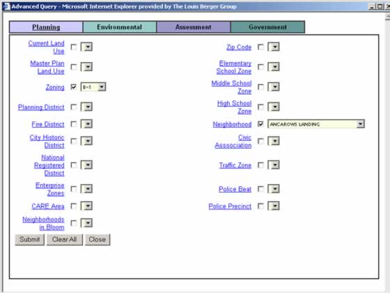
The Advanced Query tool used to access Data Warehouse Information
Authors
Edwin Gaskin, Deputy Director of Special Projects City of Richmond 501 East Franklin Street, Suite 800 Richmond, Virginia 23219 (804) 646-3171 (804) 646-6793 (fax) gaskined@ci.richmond.va.us Raymond Freeland, Director of Geospatial Information Systems The Louis Berger Group, Inc. 1819 H Street, NW Washington, DC 20006 (202) 331-7775 (202) 293-0787 (fax) rfreeland@louisberger.com |