An objective of the City of Burlington, Ontario is to ensure that municipal services meet the growing needs of our community and to provide these services in an easy-to-use and accessible manner. Keeping this in mind, the City has implemented a number of ArcIMS mapping applications that integrate and deliver our GIS information in an easy-to-use interface for the general public as well as for our developers, planners and engineers use. Our most widely accessed applications are the Zoning Bylaw and Official Plan, which connect our mapping to the corresponding bylaws and policies. Other applications that we’ve developed include: Address locator, Mayor/Councillor locator, Arena, Parks and Pools,Proposed and Current capital works, Building Permits Inquiry, Vacant/Underdeveloped Land Inquiry and Winter Control.

The City of Burlington
Background:
The City of Burlington is located on the north-west shore of Lake Ontario, and is one of many communities that make up the Golden Horseshoe on the Niagara Peninsula in southern Ontario, Canada. With a population of 144,130, Burlington is one of four municipalities that make up the Regional Municipality of Halton. Burlington is at the western end of the Greater Toronto area, and is just an hour north of the USA border.
Please visit our website at: http://www.city.burlington.on.ca/
The City of Burlington has been using GIS since 1986. In those early days we were running on a system called GDMS on our Wang mini-computer. In 1995, we purchased our first licenses of Esri’s ArcInfo and ArcView. We recently upgraded to ArcGIS version 8.1, and still maintain some of our ArcView versions 3.1 along with 8.1. ArcView is part of our standard desktop installs, and our concurrent licenses allow many staff to use it occasionally. We are running ArcIMS to serve our Internet based applications. In our Engineering Department, we are using ArcCOGO for inputting survey plans, and the ERDAS Stereo Analyst to update our topographic mapping.
Since we have been using GIS technology for so many years, we have accumulated many layers. To list just a few of these: parcels, address points, house numbers, single line and double line street network, registered plans, reference plans, condominium plans, official plan, zoning bylaw, parks, major buildings, creeks, hydrants, storm sewers, topographic mapping, aerial photography, proposed capital works, inspection and response areas, planning communities and districts, wards and polling subdivisions etc.
Internet Web Applications:
The City started our internet mapping applications using MapObjects. Our first application was a generic application for our internal users on our intranet. Shortly after this, Esri came out with ArcIMS and we decided that was the best way to go since we hadn’t developed too many MapObjects applications yet. Our next decision was whether to get external consultants to develop and code our internet mapping applications or to tackle this ourselves. Half a day was spent installing ArcIMS and about an hour to get a simple application up and running. The decision was easily made to try and code our own applications and use consultants for any more challenging applications. And so we began on the road down internet mapping applications.
First Steps:
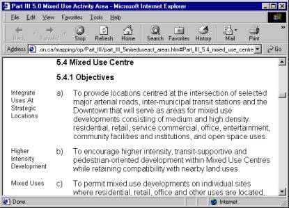
Our first steps were to identify what area of City business would most benefit from a mapping application for our external as well as internal customers. The Zoning Bylaw was identified because of the natural link between the mapping, which we already had, and the Zoning Bylaw documents. The City hired consultants and worked closely with them, converting word documents to HTML documents with embedded links and bookmarks. Staff that create these documents were trained in this aspect and are now comfortable updating and maintaining the Zoning Bylaw in this fashion.
Since this was our first mapping application, and a somewhat involved application, the consultants were also asked to create the mapping side of the program and show us how the links would work between mapping and documents. It was critical that all aspects of the hard copy maps of the Zoning Bylaw were captured in the mapping application – colour, symbols and linework had to match the bylaw exactly to reflect accurately the Zoning Bylaw.
The Zoning Bylaw Application:
After many weeks of hard work between staff and consultants, the Zoning Bylaw application was finally ready to be implemented. Shown below are screen shots of the Zoning Bylaw with explanations of how it all works:
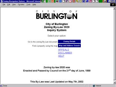
This is the starting page where a user can choose to go directly to the Zoning Bylaw documents or to view the mapping side of the Zoning Bylaw. As you’ll notice, we have a disclaimer associated with each of our internet mapping applications as well as help.
 |
This next screen shot shows a zoomed in area of the City with the zoning designations in red. You’ll notice that we only use a few of the available tools provided with ArcIMS to keep the application as simple as possible. Each of our internet mapping application has a ‘Locate Address’ button. This application has a button to identify the zoning designation and the next screen shot shows how the information is displayed when you click inside the mapping on a particular zoning.
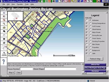
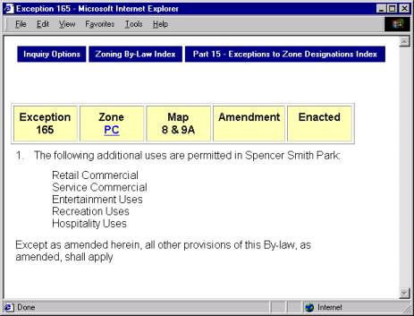
By clicking inside the long green park on the waterfront, the zoning designation of PC-165 was displayed below the map. If the user clicks on this hyperlink, the application will link directly to the zoning bylaw for the designation PC-165 – see next screen shot.

The Zoning Bylaw application has been a time saver for our developers and planners – they no longer have to come into the City offices to look up zoning bylaw information. Our front counter staff have also found it a tremendous tool for them to easily check the zoning on a property.
Looking back at the application now, it seems quite simple, but for a first application, and without a lot of experience from our staff, we feel using a consultant was a wise choice. Our staff have been able to learn from the consultants work and have created approximately 15 internet/intranet applications since then.
The Official Plan mapping application:
This application was very similar to the Zoning Bylaw application and the same consultants were used to implement it. Again, it was critical that what was displayed on the internet accurately reflected the Official Plan documents. Other factors that were different from the Zoning Bylaw were that layers (schedules) of the Official Plan could not be overlaid on each other. The consultants set up the program so that only one layer could be displayed at a time. If a user clicks to view a layer, all other layers automatically turn off. Because of the nature of the Official Plan, this was imperative.
The first page displayed with the Official Plan is similar to the Zoning Bylaw – a screen to choose to view the Official Plan documents directly or to go to the mapping.
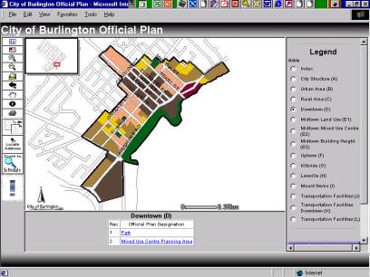 |
Shown below are screen shots of a schedule and document associated with the Official Plan. Again, if the user chooses to click inside the mapping, an html link will be displayed below to link directly to the documents – similar to the Zoning Bylaw discussed above.
Other Internet Mapping Applications:
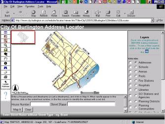
The first mapping application that the City attempted to implement ourselves, without the help of consultants, was our Address Locator. We wanted visitors to our website to be able to easily locate an address within the City of Burlington and view other pertinent information about the city such as Arenas, Pools, Hospitals, Train stations, Schools etc. This application has been very well received and used.
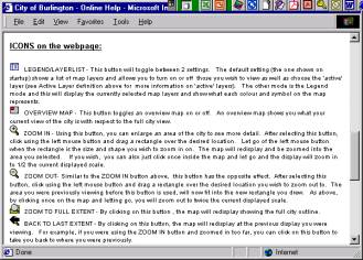
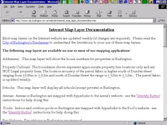
Each of our applications include a help button (question mark) and our help file explains the use of each of the tools as well as describes what each map layer includes. Example below:
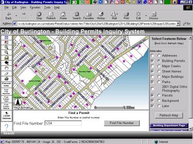
Our building permit inquiry system was developed recently and shows the permits from the last 3 years that were applied for, issued and cancelled. The capability to search by file number is shown below, but the user can also search by permit type or status. To find out more information about a permit, the user simply clicks on the Permit Info button and then clicks inside the map on the permit they are interested in. Information such as address, file number, work proposed, status and type for the selected permit will be displayed below the map.
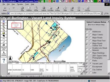
A vacant land inquiry system is also available showing vacant and underdeveloped land in Burlington. The vacant land is colour coded based on the type of vacant land. A user can click on a vacant property and find out area, zoning and owner/contact information about the property. The user can also display digital ortho photography and get a good idea of what the property looks like without having to travel there. This application is helping to promote properties in the city that are available for new industry!
Conclusion:
Both staff and the public are finding our
new web based mapping applications to be a valuable source of information
that makes their job easier and saves time. Linking our developers and planners
to the information they require in an easy to use and informative manner has
reduced the number of calls our counter staff receive and made everyone more
productive. The City of Burlington will continue to provide more mapping
applications that meet the needs of City staff as well as our internet customers.
Futures (Internet and other GIS related):
- Internet
- More and more mapping applications on the web
- E-commerce
- E-commerce capabilities for application areas such as building permit applications, license renewals, property reports
- Arc SDE
- Looking at implementing soon
- GPS – vehicle locators
- Recently completed a demonstration project for vehicle locating systems, expect to proceed with pilot later in the year for winter control vehicles
- Document Management system – link with GIS
- We’ve just started a pilot project with a new document management system, capable of storing AutoCAD drawings and large scanned images. One of our tasks through the pilot project will be to investigate linking these drawings to GIS locators
- Call Centre or Citizen Response system
- We will be investigating a system to track calls from citizens, including a GIS location.
- Infrastructure – Asset Management – Maintenance Management Systems
- We have several projects underway which will be reviewing the best way for us to improve our infrastructure and other asset management. Our Maintenance Management also is due for an upgrade, and this will, of course, be integrated into the inventory systems.
____________________________________________________________
Ann Evans, GIS Application Analyst, City of Burlington, Ontario, Canada
evansa@city.burlington.on.ca