Dr. J.G. Prins, HDR Engineering, Inc., Folsom CA and C. O. Murray, Sonoma County Water Agency, Santa Rosa, CA
Sonoma Valley County Sanitary District (District) conducted a sanitary sewer overflow (SSO) prevention study using an ArcView GIS Interface as the central analytical tool to structure the SSO prevention plan and develop a prioritized implementation plan. The ArcView GIS interface utilized land use, sewer inspection data, reported overflows, flow monitoring, and hydraulic modeling results to develop an overflow prevention plan. The plan considered upsizing and rehabilitation for the sewers to reduce inflows and infiltration to prevent SSOs. This system will be used to identify future sewer rehabilitation projects based on the sewer's structural condition and the I/I reduction potential. The process includes a feedback mechanism to update the structural condition assessments and confidence levels as more inspection data became available.
This paper illustrates how GIS can be used in building a decision support system to maintain sewer maintenance and system improvement plans for building, managing, and maintaining better sewer systems.
Sanitary sewer overflows (SSOs) is not only a potential source for polluting public waters (e.g., creeks, rivers, lakes, beaches, etc.), it also poses a potential health risk to the users of these public water. Regulatory agencies, such as Water Quality Control Boards (WQCB), impose heavy penalties on sewer system management agencies that allow SSOs in their systems. They also require from these sewer system management agency to develop a SSO prevention plan to minimize the risk of associated with SSOs.
In sanitary sewer systems overflows can be cause by various type of pipe defects and/or pipe capacity limitations. Typically, SSOs are due to hydraulic capacity limitation during high flow conditions. These limitations can be due to limiting pipe sizes or physical obstructions in the pipe (e.g., roots, grease, intruding lateral connections, etc.). In most systems with SSO problems, the high flows in the sewer system are during the wet weather season and particularly during or immediately after a heavy rain event. Although sanitary sewer systems are not designed to convey storm runoff, it is inevitable that some of the rainfall will enter the sewers. Potential wet weather inflow and infiltration (I/I) sources are interconnections between storm drain and sanitary sewer systems, cracks or breaks in pipes and manholes that allow ground water to infiltrated the sewer systems, high ground water levels to that induce hydrostatic pressure on pipes, etc.
The SSO preventive measurements (e.g., sewer system upsizing or sewer rehabilitation projects) can be costly depending on the condition of the existing sewer system, the extent of the hydraulic restrictions, and the required level of SSO protection. A typical approach to establish the most feasible level of SSO protection level includes the development of system preventative measures for a range of design storm events (e.g., 2-, 5-, 10-, and 20-year design events). Another factor to consider in the development of these measures is land use. Depending on the develop potential in the sewer system's service area, an increase land use might not only dictate the sewer improvement method, but also the scheduling of identified projects.
From the above it is apparent that in developing SSO prevention plans engineers have to combine several data sources, conduct model runs for multiple what-if scenarios, develop improvement options for several design storm events and land use scenarios, etc. The data used in this process to construct the hydraulic models, conduct the sewer system condition assessments, etc. were developed ~n GIS and could be maintained in GIS to keep the plan updated. More importantly, GIS is a powerful modeling tool that can be used to extract model input data, manage the various modeling scenarios, and analyzing and presenting results.
The potential for utilizing GIS as a decision support system (DSS) tool in the investigating and developing of an optimized SSO prevention plan can best be illustrated in a case study. This paper provide an overview of the GIS tools and the modeling interfaces used in the recent SSO prevention plan developed for Sonoma Valley County Sanitary District (District). It demonstrates the potential for GIS and GIS-based tools to increase productivity, to combine multiple data sources in the decision making process, manage various modeling scenarios and improvement plans, and to develop dynamic and optimized implementation plans. The latter was designed to comply with regulatory requirements and allow for future land use growth in the study area.
Since the release of ArcView 2.0 Dr. Prins developed several ArcView GIS tools to enhance productivity by automating data processing. He also developed a GIS-Modeling interface approach to enable non-GIS users to utilize the power of GIS in the development of hydraulic models. The following discussion will highlight some of these features.
Although GIS is a powerful tool for manipulation and editing geographic data, it does require a high user-skills level to optimize the utilization of these tools, to find short cuts for doing repetitive work, to conduct quality control checks, and to use the more advance GIS functionality embedded in the ArcView objects. In basic tools provided in ArcView GIS also lack some functionality that is essential for maintaining sewer, storm, or water networks (e.g., to snap nodes to lines). The ArcView tools included in the GIS-Modeling interface were specifically designed to make GIS accessible to non-skilled users, to overcome some of the shortcomings in ArcView, and to enhance productivity by automating repetitive task, quality control checks, etc. Two examples of the tools used on the District's project are reviewed below.
Line-Node Editing Tools
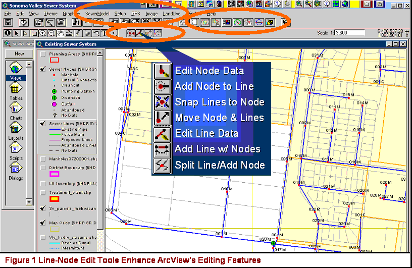
The added tools include a set of line-node editing tools that allow users to edit a line and node theme simultaneously. These tools support cross theme snapping, entering of X- and Y-coordinates (i.e., say from as-built drawings), and a setup dialog to select the line and node theme to edit. Neither theme has to be in edit mode to use these tools. The tools allow adding a node to a line's end point, snapping lines to a node, adding a line with nodes at its end points, and splitting a line and adding a node at the split-point.
Customized dialogs can be added to edit line and node attributes, assign manhole numbers, maintain line-to-node topology, and link lines and nodes to other related data sources (e.g., inspection data). Figure 1 illustrates how these tools can be used to edit line or node attributes, and linked information (e.g., manhole inspection photos) to the input dialogs. These dialogs can be designed to support an intuitive data input format, predefined input selections, etc. to enable low skilled user to enter and maintain the system data.
Layout Management Tool
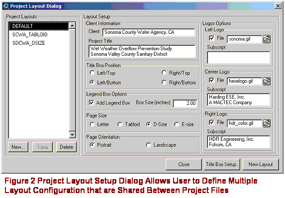
Creating layouts with a consistent look in Arcview has always been a challenge. However, the Layout Manager Tool overcomes most of the layout formatting hurdles. As illustrated in Figure 2, the tool provides a Project Layout Setup dialog that enable users to define multiple typical layout formats to be used on the project. The project layout setup data are stored in separate text file (i.e., not in the Arcview project file) and any project file that has the Layout Management Tool extension loaded can share the settings.
A menu item allows the user to open the Project Layout Setup dialog. The user can add or delete layout setups, or can edit an existing setup. To create a new layout, the user can select a layout setup and click on the New Layout button. The layout will be sized and oriented according to specifications and a border, title box, logos, and captions will be added. A menu item allows the user to open the Title Box Dialog to edit the plot title, scale settings, plot number, etc.
The model extraction approached used for the District's project was developed over several years. Two previous papers (i.e., Prins, 1998 and Prins, 2000) address the GIS-Modeling interface approach and model extraction features in more detail. The GIS-Modeling interface features two major components: the model extraction process; and the land use plan development process. The following is a overview of these two processes.
Model Extraction Process
As illustrated in Figure 3, the model extraction process is a predefined data management system with build-in functionality that link hydraulic model models for multiple system configuration alternatives to the raw data sources (e.g., the base sewer coverage, service areas, and land use). Menu options guide the user through a three-tier model extraction process, allow the user to connect service areas to flow injection manholes, and export the extracted model to an input file for the hydraulic modeling software. This process requires minimal user input. Users are only required to select the modeling alternatives and land use scenarios that define the specific modeling configuration and flow conditions.
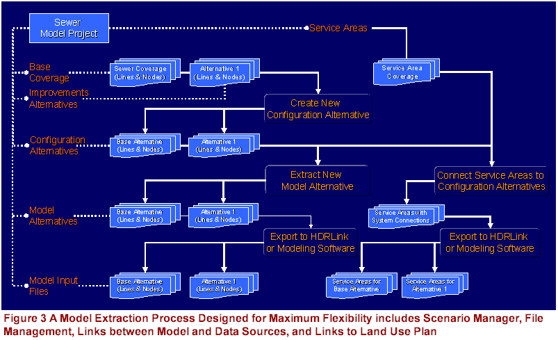
This process has several advantages, which include minimizing errors in data processing, minimizing the data management time, maximizing the data management flexibility, minimizing data redundancy, and establishing a repeatable process for generating hydraulic models. The most important benefit of this approach is the dynamic link it establishes between the raw data sources and the hydraulic model. This allows users (e.g., the District) to update the models and the associated system improvement plan with any changes to the raw data sources (e.g., addition of new lines, rehabilitation of lines, or new land use developments).
The scenario manager features (i.e., the ability to develop multiple model alternatives) make this an ideal tool for generating a range of model simulations required for a decision support system. It allows the user to create and update (i.e. with changes to the raw data sources) several model configuration alternatives with minimal effort. The effort saved in the data management and model development make it possible to focus more on optimizing the system improvement plans and to look at more alternatives than would otherwise be possible.
Land Use Extraction Process
Land use is a key input to any infrastructure master plan (i.e., water, sewer, stormwater, transportation, etc.). The land use extraction process developed by Dr. Prins (see Prins, 2000) has been used to develop a land use plan for the study-area. A customized dialog guides the user though the land use plan development process. As illustrated in Figure 4, the process is designed to extract land use from parcel level information and aggregate it per planning area. It generates a land use projection for each planning area than includes at minimum existing land use and buildout land use. The projection model supports interim land use projection for each planning area. An annual growth rate per planning area and user-defined time steps are required to calculate these interim projects.
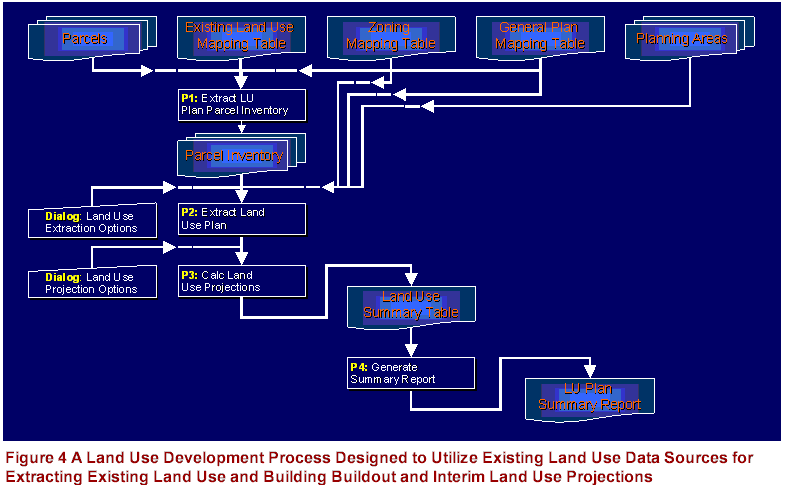
Land use driven model input (e.g., sewer inflows) is calculated by overlaying a set of service area polygons on the planning areas. Polygon-on-polygon intersection and a proportional assignment approach are used to calculate the land use contributing to each service area for a given land use scenario. Unit conversion factors (e.g., unit sewer flow generation factors) can be used to convert the contributing land use to require model input (e.g., sewer flows). This process allows the user to update the land use plan and the associated model scenarios with any changes to the land use data (e.g., new development). The extraction process can be designed to support parcel overlay coverages to develop alternative land use plans.
It is apparent that this system has the potential to evaluate numerous alternatives with minimal effort. This enables engineers and planners to explore the impact of short and long-term development on the supporting infrastructure. Thus, making this process ideal for building a comprehensive decision support system.
The District's SSO prevention plan project included data collection to determine the current condition of the sewers and to quantify the wet weather related inflow into the sewer system. The collection system inspections include manhole inspection (i.e., including lamping data that provide some indication of the condition of the connecting pipes), CCTV pipe inspections, and smoke testing. Flow monitoring was conducted at several locations along the trunk sewers. The flow monitoring program included two flow monitoring periods covering two consecutive raining seasons. Plant inflow records for the same periods were also used as a flow data source.
After analyzing the inspection and flow monitoring data, the results were summarized in database tables with references to the associated entities in the collection system (e.g., flow meter location, pipe locations, etc.). These data sources were linked to the collection system coverage and an integrated data management approach was defined to use these data source in the development of a SSO prevention plan that complies with the RWQCB's requirements. Two of the features of this data management system are discussed below.
 It was not feasible or possible to inspect
every pipe segment or every manhole in the collection system. A linear
interpolation method was used to extrapolate the condition assessment
rating of existing lines to estimate the probable condition of un-inspected
lines. The estimated condition rating included a relative pipe score (i.e., a
relative rating of the pipe condition - ranging between 0 and 4 with 4
representing the worst pipe condition) and a pipe score confidence rating
(i.e., the confidence in the pipe score ranging - ranging between 0 and 100
percent).
It was not feasible or possible to inspect
every pipe segment or every manhole in the collection system. A linear
interpolation method was used to extrapolate the condition assessment
rating of existing lines to estimate the probable condition of un-inspected
lines. The estimated condition rating included a relative pipe score (i.e., a
relative rating of the pipe condition - ranging between 0 and 4 with 4
representing the worst pipe condition) and a pipe score confidence rating
(i.e., the confidence in the pipe score ranging - ranging between 0 and 100
percent).
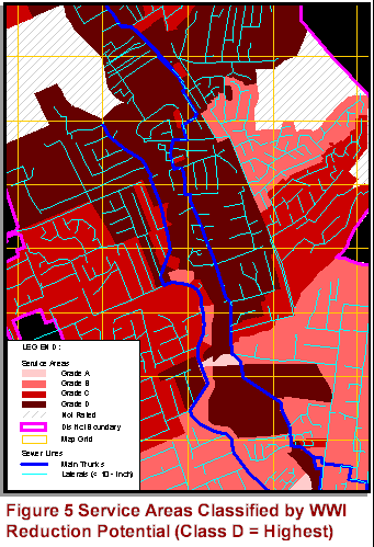
The flow monitoring data analysis quantified two wet weather flow components, a wet weather inflow (WWI) and a rainfall dependent inflow and infiltration (RDI/I) component. These two parameters were used in conjunction with the pipe condition scores to estimate an average WWI Reduction Potential for each service area. This parameter is relative rating of the potential to reduce WWI into the sewers by rehabilitating all the sewer defects in the service area.
Figure 5 illustrate how GIS was used to process and present the inspection and flow data. These data overlays made it possible to identify the problem areas in the system and to verify these observations by comparing it to known overflow locations. The service areas with the highest WWI Reduction Potential were identified as the focal point for potential future sewer rehabilitation projects. Hydraulic model runs were conducted to assess the potential impact of sewer rehabilitation on flow conditions in the sewer and whether sewer rehabilitation alone could be considered feasible SSO prevention option. The results of these model runs will be presented below.
The GIS tools were used to develop a series of dynamic hydraulic models of the sewer system. Before the models were used in the analysis, it was calibrated by comparing simulated dry and wet weather flows with the observed flows at the various flow monitoring locations. The calibrated model could be used with confidence to simulate flow conditions for various growth and wet weather scenarios. The modeled scenarios represented a combination of the following flow events:
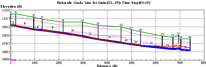
The simulation results (as shown in Figure 6) were used to determine the potential location of overflows on the modeled trunk system and the potential duration and volume of these overf1ows.
|
|
By combining the model results from various modeled scenarios it was possible to identify conveyance restriction in the system and find the most feasible and appropriate SSO prevention strategy. Most of the analysis was conducted in GIS using standard ArcView GIS features. The analysis approach, as demonstrated in Figure 7, included the following:
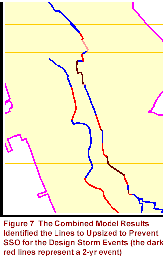 The results from the model scenarios that simulate
flow conditions under bui1dout land use and the 2-, S-, 10-, and 20-year
design storm events were combined to identify the lines that should be upsized
to avoid SSO under the design storm flow conditions.
The results from the model scenarios that simulate
flow conditions under bui1dout land use and the 2-, S-, 10-, and 20-year
design storm events were combined to identify the lines that should be upsized
to avoid SSO under the design storm flow conditions.
Based on this analysis it was concluded that sewer rehabilitation is not a feasible SSO prevention option and that upsizing of the trunk sewer provides a more feasible SSO prevention solution.
The next step in the project was to develop a workable sewer system improvement plan. This plan focused on the following two improvement components.
The hydraulic analysis to define the SSO prevention plan identified the lines that required upsizing to prevent SSOs. However, several other lines have conveyance limitations that result in severe surcharging during design flow conditions. The pipe inspection data (i.e., mostly CCTV data) for the trunk system indicated that large segments of the trunk system would require rehabilitation over the short- to medium-term. The selected sewer improvement plan included improvements that improve the sewer system capacity, minimize the potential for overflows, and rehabilitate the trunk sewers.
GIS was used to identify the conditions that require improvements to the line (i.e., SSOs, conveyance limitation, or structural defects). An implementation priority was assigned to each line that requires improvements. This priority was based on the pipe condition scores, the confidence in these scores, and the capacity rating of sewers, and potential that the line's capacity limitation can cause a SSo. The highest implementation priority was assigned to lines that require upsizing to prevent SSOs or to lines with severe structural defect.
It was assumed that sewer rehabilitation would be sufficient to address lateral improvement needs. In order to maximize the capacity of the system it was decided to consider pipe bursting as the only feasible rehabilitation method. Using the estimated pipe defect scores of the individual pipes in a service area, an average pipe score were calculated for each service area. A rehabilitation priority classification was assigned to each service area based on its average pipe score. These classifications were used to develop a prioritized rehabilitation implementation plan.
A weighted confidence score as calculated for the average pipe score of each service area. The District plans use this confidence rating in conjunction with pipe scores to identify service area with the highest need for CCTV inspection. The CCTV program will be designed to inspect the pipe with pipe scores and low pipe score confidence levels.
The case study presented in this paper demonstrates how GIS could be used as an integral tool in developing a SSO prevention study and a prioritized project improvement and implementation plan. An important factor in the success of this project was that the project was planned and executed through GIS. GIS was not only the mapping tool, it was the central analytical tool. Other tools (e.g., the engineering models) were used to develop input to the GIS analytical process. Another success in this project was the customized functionality added to ArcView GIS to develop a decision support system that integrated GIS data sources, inspection data, and hydraulic modeling results.
Thanks to Sonoma County Water Agency and the Sonoma Valley County Sanitary District for allowing us to use their project as a case study.
The methodology for extrapolating the pipe scores of inspected lines to the un-inspected pipes was developed by William Greene from Harding ESE. Harding ESE acted as the main contractor for the project with HDR as sub-contractor to Harding ESE. Harding ESE was responsible for all the engineering and planning input. HDR work with the District's GIS consultant to develop the GIS data and was responsible for developing the hydraulic models and the GIS-model interface defined in this paper.
Prins, J.G. Dr, Reil, J.R., Madison, M.J., and Swimley, C.E., Develop a Sewer Master Plan with a Dynamic Link to GIS Using ArcView, Esri User's Conference (1998), San Diego, CA.
Prins J.G. Dr. and Bodeaux, Marcie, Building Land Use Plans for Water and Wastewater Master Plans: A Case Study, Esri User's Conference (2000), San Diego, CA.
Dr. J.G. "Koos" Prins
is a Senior Professional Associate at HDR Engineering, Inc.
C. O. Murray is an Water Agency Engineer at Sonoma County Water Agency,
Santa Rosa, CA.