Integrating Environmental Monitoring Data into GIS for the World Trade
Center Emergency Response
Harvey Simon and Mark Gallo, United States Environmental
Protection Agency (EPA) Region 2
In the aftermath of the September 11 World Trade Center Disaster, the EPA was
responsible for collecting, analyzing and interpreting a wide variety of
environmental data to make decisions about worker safety protection and public
health. This paper describes the process of creating a monitoring
database, integration of monitoring data into GIS during a crisis, and how data
processing procedures evolved to streamline the flow of information from field
collection and laboratories into data analysis systems to support decision
making.
Introduction
On
the morning of September 11, 2001 Region 2 employees watched in horror as the
WTC burned. Few saw both planes hit the buildings, but most were watching
when the second plane struck. Employees quickly evacuated the Region 2
main office at 290
Broadway, less than six blocks from the World Trade Center (WTC). They were on the streets when the towers fell. The evacuation
was rapid. People grabbed their things and left as quickly as possible. Computers, printers, and
other electronic devices were left running. Although frightening, the evacuation
was remarkably orderly. Employees went their separate ways outside the building,
making their ways home under difficult conditions. Within hours Region 2
emergency operations were responding to the scene.
|

(Photo Credit: John Ciorciari
http://www.geocities.com/ccng2/wtc_02.html) |
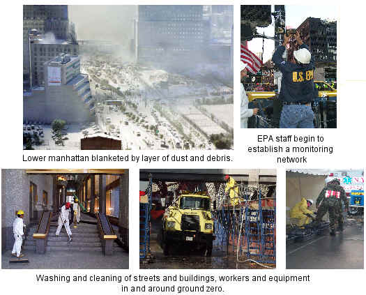
| The collapse of the World Trade Center created the need for
a coordinated emergency response effort unlike any that EPA had experienced
before. When the towers fell, lower Manhattan was coated in a thick layer of
dust and ash. The fires filled the air with acrid smoke. Region 2 responded
by vacuuming streets and buildings, decontaminating workers and equipment at
ground zero, and monitoring the dust, air and water in and around ground
zero. Sampling teams were sent into the field to monitor the air in Brooklyn
neighborhoods where the massive plume from the WTC site was drifting. |
(Photo Credit: EPA Emergency Response Staff)
Air samples were also collected from sites in New Jersey across
the Hudson River from the WTC. EPA On-Scene Coordinators (OSCs) went near Ground Zero, to survey the environmental damage and
collect bulk dust that had been dispersed all over as the towers collapsed. The air
and bulk samples were quickly delivered by car to private laboratories and the
Emergency Response Team's laboratory in Edison; the results were obtained overnight, providing
valuable information on the types and levels of contaminants that had been
released so the health of thousands of rescue workers and those residents in the
surrounding communities could be protected. Extensive monitoring for
asbestos, particulates, metals, and organics was maintained in lower Manhattan,
and at more remote sites in the five boroughs and New Jersey from the first few
days of the disaster until the site was cleared in late June, 2002.
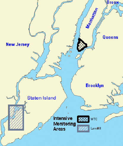
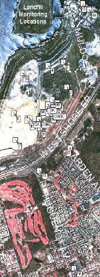
Monitoring at the Staten Island Landfill, which was used as a storage point for
debris from the site to sift for remains and evidence, is still ongoing.
|
 |
|
 |
 |
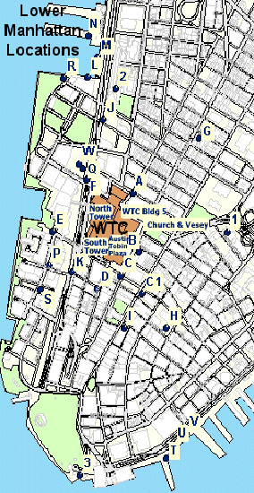
| Primary
monitoring activities were in downtown Manhattan and the vicinity of
the Staten Island Landfill, although there were many additional
regional sampling sites in the five boroughs and New Jersey. |
Region 2's GIS operation was thrown into disarray by the attack. The
central GIS Team was based in EPA's New York Office and most Team members were evacuated
on the day of the attack. Regional GIS and information
technology staff that had been evacuated from the New York office on the day of
the attacks managed to contact each other and arranged to work out of the
Region's laboratory in Edison, NJ where regional emergency operations had been
established. Within several days of the attack, they were providing full
time support to Mark Gallo, the emergency response data management and GIS lead.
Several members of the GIS Team were at an EPA GIS Work Group meeting in San
Francisco on the day of the attacks, and had to find their way home in the middle
of a national air transportation crisis. One managed to fly home eventually,
while the other two (including one of the authors) drove back by rental car.
The New York office was closed for the first few weeks, and telephone, Wide Area
Network and Internet Access were unavailable or limited for an additional 7-10
days. By luck, a mirror of all the Region's GIS data and applications had
been maintained at the Edison Laboratory for several years - the purpose of this
mirror was to improve performance for users in Edison, not for continuing
operations in a crisis. EPA GIS operations for the World Trade Center were
based entirely in Edison until the New York office was fully functional.
Data Management Challenges
As the EPA response to the disaster evolved, it became clear that there were
huge data management challenges that had to be resolved:
- Need for rapid, near-time processing of data for operational decisions,
worker safety and public information: In addition to requiring rapid
processing of data to support operational and public health decisions, EPA
senior management decided very early on that monitoring data would be
published via the Internet in as close to real time as possible. This
was an unprecedented activity for EPA.
- Multiple organizations collecting data, need for central clearinghouse:
Many other organizations were also collecting data for the response and New
York City requested that EPA develop a multi-agency database to store and
share the information. EPA agreed to take on this role and was
responsible for distributing data and data products to responding
organizations and the public.
- Data from different agencies in multiple electronic formats and hard copy:
Many other organizations were also collecting data for the response and New
York City requested that EPA develop a multi-agency database to store and
share the information. Data were initially provided in a wide variety of
formats from paper to electronic spreadsheets, often with almost no metadata
or background information.
- EPA data processing initially hard copy driven and not standardized: In
the early stages of the response data were being delivered in hard copy format
and entered into the database by hand, a laborious, error prone and time
consuming process.
- Need for definition of cartographic product and data report requirements
for a variety of uses: Many of the responding organizations, including EPA
were “disconnected” while working in the field, and many local resident had no
phone service or Internet access for extended periods of time. Production of
hard copy maps and reports that effectively summarized data was vital to field
work and communication with the public.
- Need for accurate base map, remote sensed and operational data: New York
City's Emergency Operations Center (EOC) was destroyed the day of the attacks,
but was re-established on a pier along the Hudson River within 48 hours of the
event. Region 2 staff obtained critical base map information from the EOC
mapping center to ensure that EPA was working from the same base information
as other responding agencies.
- Need for effective internal and external data coordination: The
overwhelming amount of data, coupled with the need for rapid and effective
dissemination to responders, managers and the public made effective
coordination critical.
Data Management and Geospatial Support
Managing and Georeferencing Environmental Data
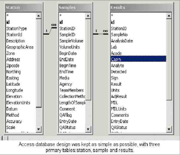
During the first few days following the attacks, Regional GIS and IT staff developed a
Microsoft Access database to house all EPA monitoring data that was being
processed by contract labs, acquired critical local data from New York City
agencies working out of the Emergency Operations Center on Manhattan's west
side, and established geocoding procedures in ArcView for monitoring locations and
incorporations of locational information into the database. In the early stages
of the response, data were being delivered in hard copy format and entered into
the database by hand, a laborious, error prone and time consuming process. The
Region 2 GIS Team developed automated procedures for data entry that radically
reduced errors and data entry work effort.
Many other organizations were also collecting data for the response and New
York City requested that EPA develop a multi-agency database to store and share
the information. EPA Office of Environmental Information (OEI) and OEI Systems Development (SDC) contract staff developed this database using the Region 2 Access
database as a model within less then a week of this request. This required SDC
staff to design, develop and implement a database management operation capable
of tracking the results of environmental monitoring being conducted by 13 city,
state, and federal agencies at the World Trade Center site. The system provided
a front end interface with a wide range of search options and provides standard
reports as well as download capabilities. SDC staff designed data entry
templates and worked with the relevant organizations to facilitate the
collection of their data into the system in whatever way was most efficient. At
times this involved painstaking manual data entry of monitoring results from
organizations who had lost their electronic connectivity – could not upload data
results into a database - and were operating in "paper and fax" mode to submit
their sampling results. In all, information from hundreds of monitoring sites
covering a broad range of media and substances was entered into the database
and made available for analysis and decision-making to Agency and City
officials. Access to the Multi-Agency Database was provided through
a web interface developed by OEI which allowed EPA staff and participating
agencies to easily extract data.
Web Delivery of Monitoring Results to Public
On the heels of the delivery
of the WTC monitoring database was the challenge of providing public
access to real-time status of monitoring results around the WTC. OEI developed
procedures for incorporating data from the multi-agency database into public
access web pages. A team of OEI, Region 2, Office of Air Quality Planning
and Standards (OAQPS) and SDC staff collaborated in the
development and delivery of a series of WTC data presentations – posted on EPA's
Homepage beginning in early October - that provided users with detailed
information on monitoring results at the WTC and the surrounding environment. These
data presentations incorporated detailed maps of monitoring locations, utilizing
base data layers provided by New York City, data tables showing specific
monitoring results and incorporated context developed by EPA experts for public
dissemination. To assure the data was kept as current as possible, an automated
process was put in place to update the website presentations as the database
itself was updated each day. This way, the public had access to the most current
data in the database as it was received and EPA website statistics show that
these materials received hundreds of thousands of hits over October and
November. This was EPA's first attempt at near real-time delivery of emergency
response sampling. (see http://www.epa.gov/wtc/).
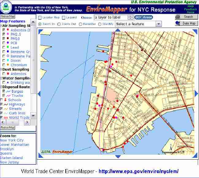
To assure that web site users had a fully integrated view of the monitoring
activities surrounding the WTC, the OEI/SDC Geospatial Team designed and
developed a customized EnviroMapper for NYC Response utilizing ArcIMS. Building on the success of
EPA's existing EnviroMapper applications, the NYC Response EnviroMapper
provides a sophisticated interactive mapping interface that allows the user to
select a geographic area and receive back a map that shows where environmental
monitoring was conducted in the selected area, the type of monitoring done and
the results that were found. (see
http://www.epa.gov/enviro/nyc/em/)
Development of Data Summaries, Trend Analysis and Cartographic Products and
Disseminating Information to EPA Staff and Cooperating Federal, State and Local
Agencies
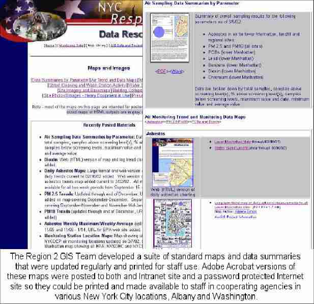
One of the telling aspects of this crisis was the impact on
telecommunications. Many of the responding organizations, including EPA were
“disconnected” while working in the field, and many local residents had no phone
service or Internet access for extended periods of time. Production of hard copy
maps and reports that effectively summarized data was vital to field work and
communication with the effected public. The Region 2 GIS Team developed a suite
of standard maps and data summaries that were updated regularly and printed for
staff use. Adobe Acrobat versions of these maps were posted to both and Intranet
site and a password protected Internet site so they could be printed and made
available to staff in cooperating agencies in various New York City locations,
Albany and Washington. These outputs were used at dozens of small and large
internal, interagency and public meetings, (including Senate and New York City Council
hearings) to explain air quality conditions and trends. Many of these outputs
were developed in cooperation with New York City Department of Health staff
involved in risk communication.
Lessons Learned
This incident stretched EPA's and other government organizations resources in
unprecedented ways. Based on our experience in dealing with data
management and geospatial support, a number of lessons learned became apparent,
many of which could provide useful guidance to any organization trying to
prepare for large disasters or dislocations.
Disaster Recovery, Failover and Backup
- You might be at the center of a disaster and need to be able to protect
your staff and offices, and get back in operation swiftly:
- Develop individual office Emergency Response Plans which will itemize
those critical functions that need to be provided and how to accomplish
these tasks should we be unable to use our offices.
- Develop a telephone and e-mail contact list for all members of the staff
which would be published in “paper” and through a secure web site available
to authorized users. In addition, develop a contact list for those that we
would need to keep in contact with in future events (i.e., other Federal,
state and local governments, grantees, vendors, etc.).
- Establish back-up plans for continuing critical work functions should an
office be unable to continue its operations. Develop plans that would
permit business continuing should an office be down or were unable to gain
access to various Agency and Regional automated systems – Develop a
telephone cascade plan so that information can be moved from employee to
employee. Home phone, cell phone and e-mail contact information for key
employees with emergency response roles.
- Establish web sites and off-premise automated telephone systems that
would provide information to both staff and others needing to re-establish
communications with EPA. – Consider telephone service from several Central
Offices, rather than just one. Using more than one vendor does not guarantee
they are not using the same physical network - you must verify and ask the
right questions of service providers.
- Supplement digital telephone service with analog for emergency purposes.
- Cell phones, wireless and web-based e-mail critical assets.
- Non-emergency security procedures may hurt you in a crisis, plan for
flexibility when trying to re-establish operations..
- Plan for alternate locations which can accommodate large numbers of
staff, including the necessary voice, data, and e-mail infrastructure.
- Mirror all critical data and applications at disaster recovery
location(s).
- Maintain a good relationship with your hardware and software vendors.
Vendor flexibility and support during the crisis were invaluable.
Esri, for example, provided tremendous support to New York City in
establishing it's Emergency Mapping Center, and responded quickly to give
Region 2 temporary ArcGIS licenses for new machines installed in the Edison
Laboratory.
Data Management, Data Analysis and Information Product Development
- Maintain IT capabilities and infrastructure: Veteran staff and contract
support with broad skills, flexibility, and communication skills that
understand Agency business are invaluable and in short supply in a crisis.
- Networking/Telecom, RDBMS, programming, GIS, web development skills are
all critical.
- Keeping equipment up-to-date is vital
- Establish internal and external roles and responsibilities and
coordination mechanisms in advance of a crisis, or as early as possible. Keep
staff with poor communication, planning and team skills out of key
coordination roles.
- Support development of an emergency response data management
infrastructure that will provide emergency response teams with the necessary
database and presentation tools to allow information to be efficiently
recorded in a standardized format, available for decision-making and made
accessible to the public.
- Replace paper driven data collection, data delivery and QA processes
with standards-based electronic processes that flow into data systems that
support rapid integration and analysis. Don’t take years to do this.
- Make data management and analysis an integral part of the data
collection planning process. Know why you are collecting information and
what you hope to use it for, and be aware of who else needs it. Secondary
use is often more important than your own internal needs.
- Presume that in a large emergency, public dissemination of critical
information is an integral part of your emergency response work - and plan
for it.
- Develop web templates for hazard information for important contaminants
in advance. Development of this type of text takes more time than
preparing the data.
- Develop secure Extranet means to facilitate sharing of data, data
services, and other information by responding organizations. Web services
and geoservices have a big role here. Run scenarios and test how to do this
in non-crisis situations.
- Have ability to rapidly collect remote sensed information in place in
advance. Define some standard delivery products that integrate well with
existing software and staff capabilities. Raw data or difficult to
understand remote sensing information is worse than nothing in a crisis.
- Work with multiple involved agencies to develop good metadata for shared
information
- Design information products for different audiences and media
- Graphic, easily understandable summaries of complex data invaluable
- Hard copy needed as well as electronic and web
- Need multiple mechanisms for dissemination
Conclusion
The varied elements of geospatial support for the World Trade Center response
have important implications for EPA and its partners. The lessons learned from
this experience will hopefully help the Agency prepare for the data management
and analysis demands of future events, establish the infrastructure to continue
operations when our own offices are affected by disasters, and prepare the means
in advance to facilitate interagency cooperation and data sharing in a crisis.
DISCLAIMERS AND COPYRIGHTS
The content of this paper does not necessarily reflect the position or policy
of the Environmental Protection Agency, nor does mention of trade names,
commercial products, or organizations imply endorsement by the Environmental
Protection Agency or the federal government.
ACKNOWLEDGMENTS
EPA's data and geospatial support for the World Trade Center was a highly collaborative effort with many participants making
significant contributions, including:
EPA Region 2
Roch Baamonde, Bonnie Bellow,
Yue-On Chiu, Robert Eckman, John Filippelli, Kenneth Fradkin, Bill Hansen, Barry
Kaye, Bob Kelly, Carlos Kercado, Bob Messina, George Nossa, Barbara Pastalove,
Harvey Simon, Robert Simpson, Stan Stephansen, Daisy Tang, Linda Timander, Erwin
Smieszek, Richard Stapleton, Raymond Werner
EPA Office of Environmental
Information
Debbie Villari, Dave Wolf, Julie Kocher
Systems Development Center
Adam Deer, Mash Eslami, Matt
Moss, Michele Passarelli,
Vincent Zhuang
EPA Office of Air Quality Planning and
Standards
Fred Dimmick, Dierdre Murphy,
Debbie Stackhouse, David Mintz
New York City Emergency Mapping Center
Paul Katzer, Allan Leidner
New York State Office for Technology
Bruce Oswald, Thomas
Henderson, Bill Johnson
New York City Department of
Health
Caroline Bragdon
EPA Region 4
Don Norris (Detailed to New York from Athens Lab)
Apologies to any of the many
others who helped that may have been inadvertently left off this list.
Harvey Simon
GIS Coordinator
United States Environmental Protection Agency Region 2Mark Gallo
On-Scene Coordinator
United States Environmental Protection Agency Region 2