The Seamless Integration of Trimbleĺs GPS within ArcPad 6.0
Jason Hill
Trimble Navigation New Zealand Limited
ArcPad users recognize that numerous activities benefit significantly from the integration of GPS technology within ArcPad. GPS integration within ArcPad has not always been straightforward, however. Previously, communication between the GPS receiver and ArcPad occurred only when settings were precise. Now, new functionality within ArcPad 6.0 has made GPS integration and use significantly easier and more robust. This paper describes GPS-related operations that are now possible within ArcPad 6.0, with particular emphasis on the operation and use of Trimbleĺs GPS Pathfinder« and GeoExplorer« CE Series range of GPS receivers within ArcPad.
ArcPad users recognize the integration of GPS technology with ArcPad as being both useful and beneficial to the operation of numerous activities. ArcPad 6.0 offers additional GPS capabilities and also enables the integration of applets that enhance and expand the functional capabilities of ArcPad and its application.
One such applet is Trimbleĺs GPScorrect extension. GPScorrect enables the seamless integration of Trimbleĺs GPS Pathfinder and GeoExplorer CE Series receivers within ArcPad 6.0. It not only configures and operates GPS and real-time differential GPS functions directly within the ArcPad user interface, but it also allows postprocessed differential correction of positions by enabling GPS data to be stored alongside ArcPad-defined features. In combination with Trimbleĺs GPS Pathfinder Express online data-processing service, GPScorrect provides a cost-effective and robust way to ensure that the positional data within an ArcPad Shapefile is of a high quality.
This paper describes the application and functionality of GPScorrect and its operation within ArcPad 6.0. Particular emphasis is placed on the postprocessed differential correction capabilities provided and the continued need for postprocessed differential correction of GPS data for use in a GIS.
GPScorrect adds two significant pieces of functionality to ArcPad: seamless integration and control of a GPS receiver, and the ability to postprocess GPS data collected in the field.
GPScorrect provides a robust mechanism by which users can configure and control the Trimble GPS receiver without exiting the ArcPad software. When the extension is installed it automatically populates the GPS configuration form within ArcPad, providing all the necessary information and communication parameters. This allows a Trimble GPS Pathfinder or GeoExplorer CE Series receiver to be connected seamlessly, without the user needing any knowledge of communication parameters.
Additionally, GPScorrect provides a simple user interface with which to configure and control numerous GPS-quality-related parameters, such as elevation and PDOP mask. This interface is modeled on Trimbleĺs proven and successful GPS control interface.
When GPScorrect is in use, GPS data collected with ArcPad can be postprocessed to improve the positional accuracy of the GPS data. This is even possible for data that has been collected in the field using a real-time differential correction source such as the FAAĺs Wide Area Augmentation System (WAAS). As a result, users benefit from more flexible data collection in the field and guaranteed data quality through postprocessed differential correction in the office.
A GPS position is subject to a number of errors that reduce accuracy, for example, differences in the timing devices in the satellites and the receivers, orbit errors, the earthĺs atmosphere, and receiver noise. However, these errors can be reduced by a process called differential correction.
Differential correction is accomplished by comparing GPS data collected in the field, or by a rover, with data collected simultaneously at a known location, or base station. Because the base station data is collected at a known location, any errors can be measured and the necessary corrections can then be applied to the rover data. By removing or reducing these errors, the accuracy of the GPS position data can be greatly improved, normally from around 10 meters autonomous to 50 centimeters ľ 5 meters corrected, depending on the receiver type.
Differential correction can be done after the data is collected or as it is being collected in the field. Field correction uses a telemetry link between the base station and the field data collection system. This is called real-time differential GPS (DGPS). Today, a variety of DGPS sources are available. These include MSK beacons found in coastal areas and major waterways around the world; commercial satellite-based services available worldwide; and, in the US, the government operated Wide Area Augmentation System (WAAS). By making use of real-time DGPS, you can easily relocate features, verify data, and make decisions in the field.
If you are in an area not yet covered by any of these correction sources, you can use the existing network of reference stations to postprocess your data. Trimble provides two mechanisms that facilitate postprocessing of GPS data: the GPS Pathfinder Express online data-processing service and the GPS Pathfinder Office software. In both cases base station data is required for the process to work. Although you can set up your own base station to provide the necessary data, both GPS Pathfinder Express and GPS Pathfinder Office provide access to over 700 public base stations around the world. Look for one of the following reference stations in your area:
Ľ Trimble Reference Stations (TRSÖ)
Ľ GPS Pathfinder Community Base Stations (CBS)
Ľ Continuously Operating Reference Stations (CORS)
Ľ University NAVSTAR Consortium (UNAVCO) reference stations
Ľ International GPS Service (IGS) reference stations
The requirements of your mobile GIS application will dictate whether you should use real-time or postprocessing differential correction, or a mixture of both. Real-time differential correction is useful when you need accurate position information in the field for precise navigation, relocation of assets, or collection of data. A range of sources of real-time differential corrections is available: some at no cost and others by purchase of a subscription. Source availability depends on the location of your fieldwork and the capabilities of your GPS receiver.
Use postprocessed differential correction to collect accurate data for your GIS, where high quality data is important for the end use of the data in the GIS, but less important while in the field.
Trimbleĺs GPScorrect extension includes Trimbleĺs exclusive SuperCorrect functionality. SuperCorrect allows data collected in the field with real-time corrections to be additionally postprocessed in the office, including WAAS corrected data. It offers two main benefits: the filling of Ĺgapsĺ where real-time data became unavailable in the field and the improvement of positional data through office processing techniques. This is especially advantageous when the real-time corrections are intermittent, and it offers a form of data quality assurance. Furthermore when data is postprocessed, various differential correction techniques are available that allow the accuracy of the GPS data to be further improved.
When SuperCorrect is employed, GPScorrect can record files that contain pseudorange data. Pseudorange data allows either GPS Pathfinder Express or GPS Pathfinder Office to recalculate the positional data that was previously collected in the field. This means that you can use data collection techniques such as velocity filtering to increase accuracy in the field, and still be able to differentially correct your data in the office. Velocity filtering, as the name suggests, allows the rover data to be filtered based on velocity data in the file. Velocity data helps predict where the next position should be and smoothes out any large leaps or spikes in the data. Velocity filtering is advantageous if you are mobile and in a multipath environment, for example, if you are driving and recording streets in an urban environment.
SuperCorrect also allows rover positions that have used satellites not seen by the base station to be postprocessed. The rover data is recomputed using the common satellites between the rover and the base station.
GPScorrect works by programmatically intervening between ArcPad and the Trimble GPS receiver. This is accomplished via the extension capabilities in ArcPad 6.0. GPScorrect can both control the configuration of the receiver and intercept the position data from the receiver. This allows GPScorrect to record additional data to that logged by ArcPad. The ability to log this additional data is half the secret to how GPScorrect works.
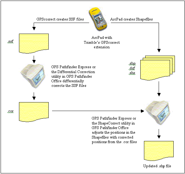
Figure 1: The GPScorrect workflow.
In Figure 1 above you will see that in addition to the normal Shapefile logged by ArcPad, GPScorrect logs a Trimble SSF file. This SSF file contains GPS position data that matches the position data inside the corresponding Shapefile. The two files share one thing in common, time. Every time ArcPad writes GPS position data to a Shapefile, GPScorrect writes a corresponding position to the SSF file.
The SSF file is then differentially corrected by either Trimbleĺs GPS Pathfinder Express online data processing service or the Differential Correction utility within the GPS Pathfinder Office software. The corrected positional data in the .COR file is then merged into the corresponding Shapefile. The position data inside the Shapefile is replaced by the differentially corrected data from Trimbleĺs .COR file. This is the other half of the GPScorrect story. The resultant Shapefiles contain all the previous information collected by ArcPad except that the position data is more accurate due to the postprocessing done in Trimbleĺs software.
With the addition of GPScorrect, ArcPad users can now employ postprocessing to guarantee the quality and consistency of their GPS data. Without GPScorrect, users will have restricted configuration options in terms of their GPS receiver and limited quality control for GPS data. Through experience, Trimble has developed an intuitive configuration interface for GPS-related parameters. This means users no longer need to learn and configure multiple communication parameters. Instead, they are provided with easy-to-understand GPS quality control options. GPScorrect also means that users can continue to benefit from real-time sources, without mitigating the requirement to have quality control over GPS data, a requirement that can only be met through postprocessing.
For further information please visit www.trimble.com.
Jason Hill is a Product Manager in Trimble's Mapping & GIS division based in Christchurch, New Zealand.