Michael C. Szarmes, M.Sc., P.Eng.
The City of Calgary is renowned for its high quality base spatial information and management. The Single Line Road Network is one of four key corporate base spatial data assets utilized throughout the organization. An 18-month corporate priority project was initiated in Q3 2001 to enhance the road network functionality and addressing capabilities within the Esri ArcGIS environment. This paper will discuss the Corporate Addressing and Mapping Project at the City of Calgary. Emphasis will be placed on project framework, base mapping management concepts and subdivision processes, maintenance environment, workflow management, system/data/application architectures, and supporting end-user applications.
The Corporate Addressing and Mapping (CAM) Project currently under development at The City of Calgary is a multi million dollar initiative to effectively bring base mapping and addressing together on behalf of the Corporation. The CAM Project was initiated in Q3 2001 after an accelerated and specialized budget and project selection process. The City of Calgary is renowned for its spatial information in terms of quality, completeness and accuracy.
A number of platforms are utilized throughout the Corporation, including Computer Aided Drafting (CAD), CAD/Oracle maintenance environments, POSSE workflow management, PeopleSoft Financial system, and Esri ArcView and ArcGIS suite of GIS software tools. Engineering Services manages and maintains the key base mapping systems for the Corporation. These include the Legal Survey Fabric (LSF), Ownership Parcel Fabric (OPF), Single Line Road Network (Roadnet), and Digital Aerial Survey (DAS).
Definition [BASE MAP] Information that serves as the spatial reference, framework or context without which users could not relate spatial features. The most fundamental of base maps is the survey control network. However, a set of points in space hardly gives a user a conceptual framework within which to work. The LSF is spatially referenced to survey control, and users can start to conceptualize the spatial framework. The OPF, built upon the LSF and based upon additional information, such as obtained by land titles, is one of the most significant and fundamental of base maps required by users. It serves not only as a means of providing the spatial framework, but also serves as a means of location referencing that is meaningful (e.g. via addresses of the ownership parcels).
The data managed within Engineering Services is leveraged to numerous platforms and systems, including CAD files, databases, and the Corporate GIS SDE environment. The major challenge for The City of Calgary is not so much the technology (although integration is always an issue to be dealt with), but more so the ultimate understanding and commitment for a corporate approach to spatial information management. In fact, it goes even further towards developing the framework that facilitates the management of Business Unit information whilst leveraging that information (both spatial and non-spatial) that is "corporate" in nature to an enterprise system.
This paper gives an in-depth look into the CAM Project within a corporate information management context at The City of Calgary, and presents the solutions that are currently under development that will move the Corporation closer to "corporate" spatial information management. In addition, some very interesting concepts relating to strategic project resourcing, categorization of deliverables given a broader context of Land Information Management, and base mapping management and the like are also included and will be of particular interest to those GIS professionals tasked with implementing corporate spatial information management (including GIS) systems.
Historically, Business Units have customized the Corporation’s existing base maps to meet their specific needs. This has created multiple versions and duplication of maps and related data, which are not integrated into the Corporate data structure, and which cannot easily be shared across the Corporation.
A similar situation has occurred with address-related information. Business Units have created new addresses within their own applications that have not been verified against other sources. Together with the mapping base, this information provides the foundation for the City’s geographic information.
The City’s Organizational Review identified a change opportunity "to rationalize the management of the City’s geographic information and consolidate data sources."
Engineering Services, Development & Building Approvals (D&BA), and ITS Business Units (sp. GIS Centre of Excellence) have seen a dramatic increase in demand for corporate data and mapping products. For example, in the last year, even with limited GIS infrastructure in place in many Business Units, concurrent hits at any time on SDE (the GIS database) have increased from 15 to 80. POSSE connects directly to SDE layers to provide maps as a reference on the desktop, and to support application/public notification processes. Integration/data sharing between POSSE, Engineering Services PUMA database, and the SDE has been in place since 1998. The CAM project will optimize this integration. There are currently over 700 active POSSE users in the Corporation.
The most efficient and accurate way of meeting pent up demand for mapping and data is through the corporate GIS, with a standardized approach to data management. Custom work currently underway for EMS to meet their specific needs for dispatching and emergency response, has reinforced the need once again for a more corporate approach to mapping and data.
Early in the project, it was agreed that a unique project management framework would be applied (Hartman, 2000). Hartman’s framework consists of tools, processes and competencies applied to project management as a means to garner stakeholder involvement and support. CAM has been coordinating this effort with the Office for Corporate Engineering Business Unit.
In April 2001, the CEO and Executive Office embarked on an Accountability Agreement approach to solicit major projects that were felt to be of direct benefit to the Corporation but that were difficult to execute due to conflicting priorities. As a result of this process, six Corporate Priority Initiatives were selected out of a group of over 30 submissions by the General Managers. The CAM Project was selected as one of these initiatives, and an Accountability Agreement document outlining the initiative was developed. This Accountability Agreement served as the initial project framework document, and outlined such items as the business case, high level deliverables, budget, project timelines, resourcing strategy, etc.
Although an accelerated process for strategic project selection, the Accountability Process in and of itself served some significant benefits: (i) it provided an opportunity to collaborate across Business Units, something that was more difficult to achieve in the regular budget approval process; (ii) it provided a unique opportunity to dedicate resources for those projects that are more strategic for the Corporation to invest; and (iii) it allowed the decision makers to compare projects based upon the same criteria and thereby position themselves to better assess the quality and corporate benefit of each submission.
The CAM Project is a collaborative effort between Engineering Services (base mapping management, spatial information management, could be considered a "data" utility for the Corporation), D&BA (planning, subdivision authority, addressing assignment, building permits and the like), and Information Technology Services (ITS). It is considered a business-driven IT Project, signifying the driving force behind the initiative. The Project was scoped as an 18 month initiative starting in Q3 2001 and scheduled for completion by the end of Q4 2002.
The high-level business objectives were initially defined in the development of the Accountability Agreement, as follows:
The CAM Project was initially approved in five (5) phases as discussed below. In addition, a transition to sustainment phase was proposed that would be completed within Q1 2003.
Phase 1 Integration of POSSE address data base into existing Roadnet, to provide a comprehensive product for EMS that is timely and accurate (early wins). This early wins phase includes:
Phase 2 Scoping Study for the Corporate Addressing and Mapping Project. This phase includes:
Phase 3 Redesign work flow processes and application of technology in Development and Building Approvals, Planning & Transportation Policy, and Engineering Services, to ensure accurate and timely updates of both spatial and address information into corporate data sets.
Phase 4 Redesign and Implement Roadnet. Leverage existing high quality mapping to ensure corporate-wide business needs can be met through the GIS environment.
Phase 5 Create and implement the Corporate Addressing component, including leveraging the work done in previous phases to improve reliability and corporate requirements.
This project structure, specifically with the inclusion of an initial early wins phase, proved to be both beneficial (in that the Project was seen to deliver early successes that could be realized), and somewhat of a hindrance (in that the scoping phase that followed the early wins phase was conducted well into the project - project chartering was conducted in Q1 2002). This created some communications challenges that needed to be overcome.
The Project Chartering Process conducted in Q1 2002 served to clarify the project scope, direction and mandate. Applying some project management concepts (Hartman, 2000), the stakeholders involved were able to arrive at a consensus regarding the expectations and scope for the remainder of the project.
The information gathered from the session was compiled and is discussed in this section.
The mission of the project is simple: "To bring accurate, up-to-date addresses and maps together for the Corporation." However, embedded within this simple mission statement are three significant concepts worthy of mention: (i) there is a requirement to merge what is traditionally tabular data (addresses) and spatial data (maps); (ii) there is a requirement to ensure the merged information is of the highest quality and currency; and (iii) there is a requirement to ensure the information is merged on behalf of and for the benefit of the Corporation (e.g. the concept of warehouse, both spatial and non-spatial).
Stakeholders were categorized into six groups and prioritized as follows:
Seven key result areas were identified into which all results-based deliverables were to fall. If the Project could achieve these results based upon a defined set of success measures, then the Project would be deemed a success. The seven key results are as follows:
Integration between Engineering Services and D&BA is a key result whereby addresses, together with those supporting processes and systems, are integrated with those related with base mapping. It is therefore worthy to note here that there is a strong connection between the first and forth key result areas. The first key result area is a process-centric approach to integrating workflow between and across multiple business units. The concepts of process steward and process as independent from those who do the work begins to govern the streamlining in this regard. Considering specifically the subdivision process, there is a lengthy process to take development applications though the planning, design and implementation phases. Base mapping, or the assignment of address to a spatial reality (e.g. OPF), becomes effectively an insertable (or supportive) process. With this in mind, the mapping sub-processes are supportive of the larger subdivision process stewarded by D&BA. The fourth key result area is a technology-centric approach to systems integration. In this way, separate Business Unit database technologies and systems are integrated directly.
There are a number of other areas that the chartering session defined. The specific measures of success are identified. These measures of success are used to indicate the success of the overall project. For example, a key measure of success that will be used to validate the success of the first key result area (workflow integration) are a series of documented workflow processes available from the process steward.
Results-based deliverables are also identified. Of course, to the stakeholder group, these deliverables serve to ensure the success of the corresponding key result area under which it falls. More about the deliverables in the next section. Process-based deliverables are more detailed sub-deliverables.
An important aspect to ensure the success of a project is the risk management and mitigation strategy. Potential risks, there likelihood and impact, when they will become live, and ultimately the mitigation actions to be taken prior to them coming live are identified up front. The mitigation strategy is embedded as process-based deliverables and assigned as scheduled.
To ensure stakeholder alignment is maintained throughout the course of the project, it is important to document up front the priorities should the project start to run of the pre-defined course. The Priority Triangle identifies the priority between time, budget and performance/scope.
Finally, in order to effectively schedule and manage a project, each deliverable can be assigned a perfect, likely and outrageous duration, or PLO Estimate. Estimation is critical to defining timelines, milestones dates and ultimately the probable end date for the project. Estimation in this way also helps to identify potential risks associated with the completion of a specific deliverable, and thereby providing valuable information to determine risk mitigation if required.
There are a number of additional points to project management and planning that will not be discussed here. However, Hartman (2000) is an excellent reference recommended.
Although CAM has documented 50 deliverables, each categorized under a key result area, this paper won’t describe them here. However, it is important to mention an important concept that helps to reconcile project deliverables within a broader corporate context. An important point for the project manager to remember is that of setting expectations and its effective management. After a broad requirements gathering exercise for the CAM Project, it became abundantly clear that the existing systems and processes within the Corporation could not satisfy user expectations. However, it was not enough to simply ignore or shelve their requirements. So the CAM Project Team conceived of a method that could classify deliverables into one of three areas as follows:
This was an important breakthrough since now deliverables could be defined and categorized with the knowledge that the CAM Project is truly the start of a bigger initiative the needs to go forward after CAM has ended (e.g. a Land Information Management Strategy). It is a recognition by the Project Team and Stakeholders that CAM can position the Corporation in such a way to ensure that a solid foundation of knowledge, experience and expertise is available to be exploited.
Bringing together and managing a diverse and highly motivated team of professionals from across a corporation, together with consultants and contracting staff, has its challenges. Couple this with a complex project involving multiple technologies, systems and processes, and it becomes evident that an effective resource management approach is a high priority. In the case of the CAM Project, there was a natural tendency to structure the team along Business Unit lines (planners on the on side, engineers and technologists on the other). Of course, a team structured in such a way does not have an environment in which to gel (or form, storm, norm and ultimately perform as a high performance team). And, considering that integration (both process and technology) were two key result areas, this would have lead to probable failure.
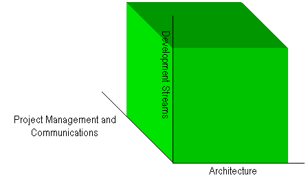
The question then became how to structure the team along different lines. An excellent approach was to divide the project team into two groups, one for technology (technical development and integration) and one for process (business process integration). Both areas, Engineering Services and D&BA, had staff to cover each side, hence facilitating a sort of team cross-pollination effect. But it became evident that something was still lacking structurally. It was at that point that the concept of the Project Resource 3D Framework (or more affectionately called the "CAM Cube") emerged. Figure 1 illustrates this resource concept.
Figure 1: CAM’s Project Resource 3D Framework
Project resources could now be allocated across three axis as follows:
With this approach to resource structuring, the Project Managers could effectively monitor and control all activities. Status meetings became much more efficient, and communications across the Project Team were open and effective, thereby addressing issues as they arose.
GIS is often considered in terms of its capacity to merge diverse spatial information and conduct analysis of geographic data. However, an equally important component to GIS is the underlying information management component. In fact, information management, in its purist form, is truly irrespective of technology and can be considered in a vendor-independent context. Having considered information (and specifically spatial information) management in this context, an added complexity arises when one brings the "corporate" perspective to the fore. One can embark upon a number of differing philosophies that would help to bring "corporate" information management to a reality within and across a corporation. A sound philosophy that is described herein allows for a conceptual segregation of Business Unit information and Corporate information. It is similar to a warehouse concept whereby corporate information is leveraged from the Business Unit databases through an Extraction/Translation/Load (ETL) process.
This Business Unit Maintenance/Enterprise Management approach allows for independent Business Unit maintenance of information within a platform and system efficient for that Business Unit. It also ensures the provision of that subset of the Business Unit information that is "corporate" in nature to be leveraged to the corporate environment (warehouse/data mart for non-spatial data, and a GIS, such as Esri ArcGIS, for spatial and non-spatial data). Of course, there are challenges and drawbacks to this approach when one begins to consider the state of the GIS technology today. Esri ArcGIS allows for both transactional and report/query access within one system architecture. It also allows for long transactions and versioning, thereby improving the spatial data maintenance processes within a single GIS environment. The Business Unit Maintenance/Enterprise Management approach, although not precluding the exploitation of long transactions and versioning, would make it more difficult to achieve and maintain.
Geomatics Division within the Engineering Services Business Unit is mandated to manage base mapping on behalf of the Corporation. This maintenance is currently done in the MicroStation CAD environment, with some connections and management of information in underlying Oracle databases. This is true of each of the LSF, whereby point information was stored in a database, the OPF, whereby parcel point and address-related information was stored a database, and Roadnet, whereby all spatial and non-spatial information was stored in an underlying database.
In 1999, a project was initiated to created an application and underlying database management system to manage all Geomatics-related spatial information within a database environment. The Geomatics’ Spatial Database Application (GSDA) was conceived to manage the Legal Survey and Ownership Parcel Fabrics, the Digital Aerial Survey data, and other spatial datasets such as the survey control network. Roadnet remained out of scope of GSDA being a highly specialized database application unto itself.
A number of governing principles within a broader spatial information management plan within Geomatics was established that would guide the development of this multi-year, multi-phase project. These governing principles are included here to give a perspective as to the fundamental underlying capabilities of the application.
Corporate Perspective
Corporate accessibility to spatial information via open sharing and alignment with corporate spatial information management initiatives is the principle objective of this management plan. Cooperation with corporate clients is key to successful implementation and use of spatial information.
Unified Spatial Data Model
A unified spatial data model capable of managing all Geomatics-related spatial base mapping information will be developed in an open environment. Spatial information will be linked together in a unified architecture and database environment.
Historical Spatial Information Management
Given the historical changes and significance of history in our developing city, management of historical mapping information is fully supported.
Relative and Absolute Coordinate Frames
Realities of mapping coordinate differences with respect to Geodetic Coordinate systems are accounted for in the management plan. It is understood that relative coordinate information can be much more important than absolute positions. Both realities are supported in a unified approach.
Management of Measurement Information
Separate management of measurements is maintained in order to obtain more reliable published coordinate values. Measurements are seen as important in the establishment of a solid base map.
Explicit Statistically Reliable Spatial Accuracy
Explicit management of statistically reliable spatial accuracy, together with their point positions, is a key principle within the mandate of this plan. Although accuracy in itself is important for a number of critical spatial management issues, what is often more important is the knowledge of the spatial accuracy, not the level of accuracy itself.
Business Information versus Spatial Accuracy
It will be understood that spatial information forms only one component of the overall information required by business units across the corporation, and that spatial information is often relatively less important than the business information it augments.
GSDA Phase I concentrated on the storing the point information that made up the LSF. This Phase was successfully completed in Q1 2001. The concept of relative coordinates (e.g. those coordinates typical in a fabric-type base map) and absolute coordinates (e.g. those coordinates traditionally tightly connected with survey control – typically GPS - in an absolute spatial frame) was also included in the model. Hence, within Phase I, the fundamental core data model for managing all coordinate based information, regardless of source, was implemented, thereby setting the foundation within which to integrate the OPF and DAS datasets.
GSDA Phase II expanded the model to include the line work and text information remaining within the LSF. This Phase was successfully completed in Q1 2002.
There are discussions around developing GSDA Phase III in 2003. This development would augment the existing point and line topology to include polygon topology for managing the OPF. The challenge for Geomatics now is the move towards providing the base spatial information within the Esri ArcGIS Geodatabase environment. Although all the information to form the ownership parcel polygons exists within the current production GSDA data model, there is an opportunity to actually create and manage the polygons within a parcel/property data model within the Geodatabase. Maintenance could continue to reside within the MicroStation/Oracle environment, with updates pushed via ArcObjects to the Geodatabase. There is much technical investigation required to assess the feasibility of this approach, but there is merit in its investigation since a large investment has been made to create the CAD/Oracle maintenance environment within GSDA.
The CAM Project is moving closer to a Business Unit Maintenance/Enterprise Management approach to spatial information management. Currently, a C-API process was developed that creates Roadnet SDE layers directly from the underlying Oracle database environment, thereby eliminating the need to convert from the CAD files using AML. This process is far more robust and efficient, and provides for better data integrity in the creation of the spatial layers within SDE.
Systems integration solutions are being developed by the CAM Project Team on a number of fronts, and, together with integrated workflow, will serve as the main benefit of the Project. Figure 2 illustrates the high-level technical architecture adopted.
Figure 2: The Systems Integration Solutions
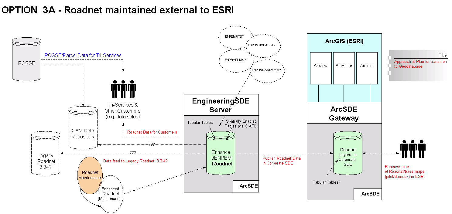
The main concept behind this solution architecture is the physical separation between the Business Unit Maintenance environment and the corporate ArcSDE environment. The Engineering SDE Server environment will be composed of a development and production server architecture and will manage all Geomatics database applications. The servers will also have an instance of SDE installed for the creation of the SDE spatial layers and SDE tables (through the C-API process) that can be QA’d by Engineering Services (e.g. the data steward/maintainer) and then pushed to the corporate ArcSDE environment for access by the corporate client community.
In addition to this, the POSSE system will be integrated with the Engineering Services parcel database and supporting data replication processes between the systems’ primary keys developed. This will ensure that the tabular representation of address within POSSE can be matched and maintained with its corresponding spatial representation with the Engineering Services parcel database.
Finally, a significant research and prototyping effort is moving ahead in the development of a Corporate Road Network logical data model and prototype based upon the Esri Essential Data Model for Transportation Networks. Development of a logical Geodatabase model with the support of a significant cross-section of the Corporate client community will help to develop an appreciation for the requirements and complexities, as well as the potential benefits of corporate spatial information management. The implementation of a prototype core Corporate Road Network (e.g. implementation of the core component of the logical data model, such as segments, junctions, address ranges and the like) will serve to gain an understanding of the technical requirements for data migration and maintenance of base mapping information given multiple user maintenance within a corporate GIS.
POSSE is the workflow management system used for workflow management (as well as the management of address-related information) within D&BA. In order to gain significant improvements in efficiencies, the processes relating to subdivision of land are being streamlined. In addition to this, Engineering Services is adopting POSSE to assist in managing workflow relating to base mapping, in support of the subdivision process. These new processes will be integrated within the broader subdivision process stewarded by D&BA (the concept of insertable process). It truly is a collaborative approach to managing address and parcel/road network information whilst recognizing the corporate responsibilities each Business Unit has to collaborate in this regard.
As mentioned above, currently, address-related information is managed and maintained within the POSSE object data model. This system is a 5NF database that is efficient for transactional access, but not efficient for reporting and querying. The solution was adopted to leverage the address-related information to a 3NF data repository within the context of the broader corporate data warehouse initiative. Application access will be developed for corporate client access to this repository.
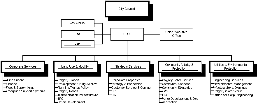
One fundamental reality of the CAM Project is that it can not resolve all issues relating to spatial information management within an enterprise context. The Project also focuses on the Subdivision process, together with the supporting base mapping processes. There is, however, a broader context in which CAM does fit: a Corporate Land Information Management Strategy. Land Information Management within a municipal government context includes processes that support annexation, long range planning, subdivision design, land use designation, development, redevelopment, inspections, assessment, taxation, and the like. Given The City of Calgary’s organizational structure (a division of 29 Business Units into 5 parallel Portfolio’s as illustrated in Figure 3), there is a real challenge to coordinate a corporate strategic initiative such as a Land Information Management Strategy that spans Portfolio boundaries.
Figure 3: The City of Calgary Organizational Structure
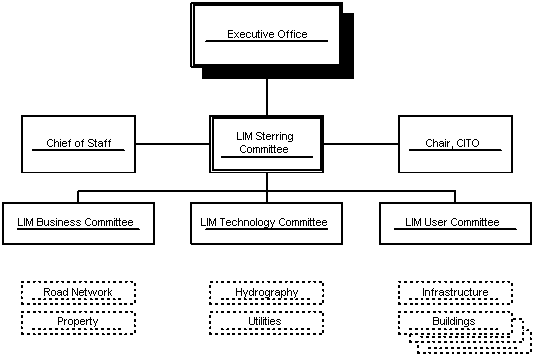
Currently, there is a proposed structure of committees being formed within a Land Information Management context that attempts to bring a diverse group of Senior Management, Management and user/client communities together. Figure 4 illustrates this proposed structure. The LIM Steering Committee is composed of a cross-section of General Managers, the Chief of Staff (linked to the Executive Office) and chaired by the Chief Information Technology Officer (CITO). Three sub-committees are structured into business, technology and user groups. Additional work can be organized in accordance with the various themes of land information, such as along the lines of the Esri Essential Data Models, or other structure suitable to the corporation. There will be challenges relating to governance, stewardship, funding, priorities and the like in order to influence the direction towards Corporate Land Information Management. However, formalizing a committee structure such as this will serve as a firm foundation to making progress in this area.
Figure 4: Proposed Land Information Management Committee Structure
The City of Calgary is, however, now formalizing a strategic group that will be embarking upon a comprehensive approach to Land Information Management starting in Q3 2002. The initial process will focus on defining the existing processes involved in the management of land within the Corporation, and the development of an implementation program to move towards comprehensive and consolidated Land Information Management. Given the state of Esri ArcGIS and other technologies, the future looks exceedingly bright that a truly enterprise approach to Land Information Management at The City of Calgary can be achieved.
Szarmes, Michael C. and P. Drake, 2002. CAM Project Charter. The City of Calgary.
Hartman, Francis T., 2000. Don’t Park Your Brain Outside: A Practical Guide to Improving Stakeholder value with SMART Management. Project Management Institute, Inc.
Michael C. Szarmes, Dipl. Surv. Tech. (Honours), B.Sc. (Distinction, Gold Medal), M.Sc. (NSERC), P.Eng.
Technical Lead, Corporate Addressing & Mapping Project, Engineering Services
The City of Calgary, PO Box 2100, Stn 'M', Calgary, Alberta, CANADA T2P 2M5
Ph: 403-268-5070 Fax: 403-268-1438 E-mail: mszarmes@gov.calgary.ab.ca