Figure 2.CIIMMS map-based search architecture.
William B. Samuels, Thomas McCarty, Nicole Soltyka, Shumei Wei, Russell Kunibe and Carol Fries
Alaska's Cooperatively Implemented Information Management System (CIIMMS) provides an interactive web site that links to a geographically distributed system of information providers. ArcIMS and the ArcIMS Web Mapping Server (WMS) Connector were chosen to perform the CIIMMS map-based search. The software is consistent with the emerging open GIS standards. The map server component provided a map-based metadata search function and allowed contributors to enter geographic location information about their data and projects in metadata records using a map-based data entry tool. This tool displays GIS layers and a digital gazetteer to generate place name keywords and bounding coordinates.
Alaska's Cooperatively Implemented Information Management System (CIIMMS) is an interactive web site developed in response to needs identified by the Cook Inlet User Community. This website was developed as part of an Exxon Valdez Oil Spill (EVOS) Restoration funded project intended to make information relative to the Exxon Valdez Oil Spill damage assessment and restoration more readily available to permitters, regulators, researchers, and the public in response to a state commitment to Cook Inlet interests.
CIIMMS is a unique website providing a one stop portal to AlaskaÆs natural resource information and data. CIIMMS utilizes existing repositories and clearinghouses and existing FGDC standards to search across profiles for biological, geospatial, and bibliographic data and information at a distributed network of locations. CIIMMS focuses on geographic locations and provides users with a means of locating information relative to a particular geographic place in Alaska using a map based search and gazetteer. CIIMMS also provides users with an opportunity to contribute their own information and data to the user community through an online metadata entry tool for projects, data, and information. A map based data entry component of the metadata entry tool makes it easy for contributors to define the particular area of interest to which the data or information pertains. Metadata can be stored in the centralized CIIMMS data or project repository or sent to the appropriate State or Federal geographic data clearinghouse node. CIIMMS also harvests information from websites that focus on Alaska resource information. CIIMMS has designed a web-links browse tree to which users can contribute website links for the web harvest. The web harvest and the search and browse functions of CIIMMS will continue to grow, becoming more valuable to the user community over time.
The system was initially developed for the Cook Inlet watershed, thus, CIIMMS needed to provide a way for the Cook Inlet community (resource managers, scientists and researchers, educators, students, industry, and individual citizens) to identify, share and access, and contribute (on-line) valuable knowledge, information, and data about the Cook Inlet watershed from a distributed network of data resources and information providers. The following six objectives were defined as necessary to meet this need:
The Alaska Department of Natural Resources (ADNR) and the Alaska Department of Environmental Conservation (ADEC) established a multi-agency project team when the CIIMMS project was launched. The team included members from the U.S. Environmental Protection Agency, the U.S. Forest Service, the U.S. Geological Survey, and the Alaska Resources Library and Information Services Library (ARLIS). Science Applications International Corporation (SAIC) provided technical guidance and support to the CIIMMS team. Team meetings were held bimonthly via teleconference in order to accommodate the dispersed locations of team members. As lead agencies, ADEC and ADNR were jointly responsible for project implementation, drawing upon the expertise within each agency. Both agencies worked cooperatively with technical consultants in the areas of hardware and software upgrade requirements, data acquisition and translation support, application development, and staff training. ADEC focused primarily on maintenance of the CIIMMS website and server, development and incorporation of ADEC databases for access by CIIMMS, and water-quality issues and database design. ADNR provided expertise in the areas of geo-referenced data issues, visualization tools, and resource management issues. The team defined a three-phased CIIMMSÆ implementation scheme:
In order to accomplish the system functionality prioritized at the CIIMMS user needs workshop, the system architecture was designed and implemented as follows: A client-server architecture was implemented, based on an Internet browser (i.e., a thin client). The data and information is served in a hybrid environment - both centralized and distributed. For example, during the pilot phase, a centralized server was provided for metadata, summarized data, and some primary data, with links established to distributed servers for sources of the majority of primary data. The CIIMMS Project Team evaluated several options in developing the prototype system architecture. These included the Chesapeake Bay system design (specifically, its metadata entry tool), the Federal Geographic Data Committee (FGDC) clearinghouse design, and several commercial-off-the-shelf (COTS) products Compusult Metamanager, Blue Angel Technology).
The Team decided to base the architecture on a COTS solution customized to reflect the short-term priority functions specified at the user needs workshop. The advantage of this COTS solution is that it offers ōout-of-the-boxö functionality that can be quickly customized for Cook Inlet. The system components, bundled together, allow for the search for, discovery of, and access to geospatial and non-gepspatial metadata and information. This is accomplished through access to (1) servers that comply with existing standards (Z39.50 protocol), (2) servers with Open Database Connectivity (ODBC) compliant databases, (3) the CIIMMS database containing metadata, project descriptions, and Cook Inlet contacts, and (4) selected web pages and hypertext.Based on its evaluation, the Project Team selected the COTS software solution, MetaStar Enterprise, developed by Blue Angel Technology for the CIIMMS Prototype system architecture. MetaStar Enterprise integrates database, search engine, and web technologies in a single solution that provides for the search and discovery of metadata and information via the Internet. Enterprise is a bundle of the MetaStar Data Entry, Repository, Gateway, and Server components. The architecture also includes the Metaharvester, which is a software robot that gathers selected information from designated websites. This tool gathers and parses XML and HTML, extracting designated elements such as HTML tags and META tags (e.g., title, body, meta, etc.). The robot will allow CIIMMS to include web-page information in its metadata database and search engine.
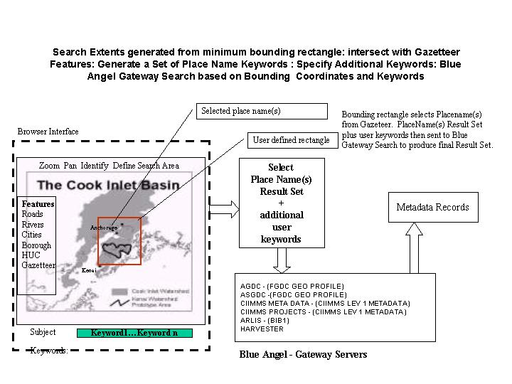
During this initial production phase, a map server component was added to provide the map-based metadata search function. This tool displays local GIS layers, selected boundary files (HUC, Quad, Borough) and a digital gazetteer to generate place name keywords and bounding rectangle coordinates. These criteria will be passed to the Blue Angel Technology MetaStar Enterprise to facilitate the search and discovery of metadata. Figure 1 shows a high-level schematic of the operational system architecture.
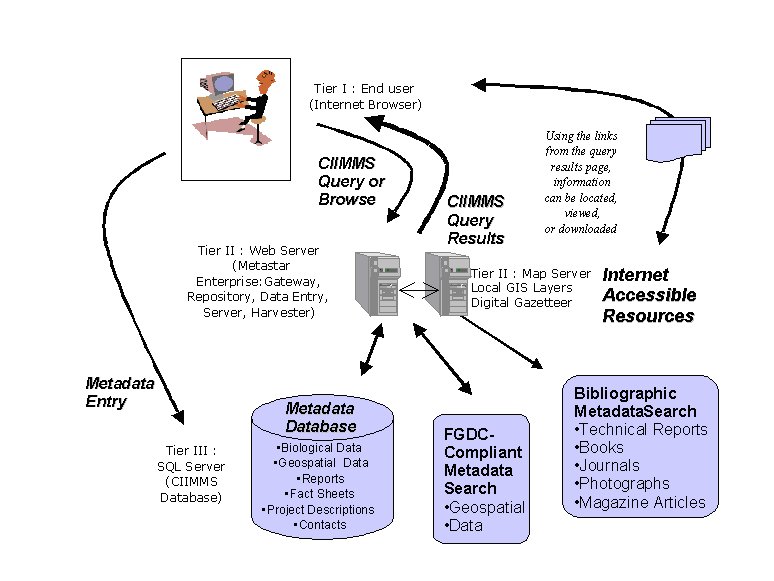
Figure 1.CIIMMS high level system architecture
The system is structured into three tiers, as follows:
CIIMMS utilizes a hybrid centralized/distributed design, meaning that some CIIMMS metadata and information resources are housed on the CIIMMS server (centralized), while other resources are housed on servers located elsewhere (at different agencies or physical locations) throughout the state (distributed). To test the distributive concept, a few distributed sites such as the ADNR Map Server, ADNR Well Log Database and the University of Alaska Environmental and Natural Resources Institute (ENRI), Macro-invertebrates database were made accessible via CIIMMS. These pioneer sites provided lessons learned and expertise to organizations interested in providing data and information access via CIIMMS. CIIMMS can help organizations become more successful at providing access to their own data and information using emerging web technologies. CIIMMS has also provided web-published guidelines and technical support. CIIMMS data access standards (i.e. Open GIS Compliance) as well as accepted ōminimumö metadata standards established through coordination between the Alaska Geographic Data Committee and the CIIMMS Advisory Group, lay the technical foundation for CIIMMS to incorporate new distributive technologies as they arise
Figure 2.CIIMMS map-based search architecture.
Use of the Z39.50 protocol allows CIIMMS to search and acquire metadata from other metadata servers. The Z39.50 standard specifies formats and procedures that standardize the exchange of information between a client and a server, allowing a user to search remote databases, identify records that meet specified criteria, and retrieve desired records. One of the primary advantages of this protocol is that it allows consistent access to a large number of diverse and heterogeneous information sources. This allows CIIMMS to search bibliographic, geospatial, and biological profiles or data sources simultaneously, a very useful, cutting edge capability.
The CIIMMS web harvest expanded to a two-level harvest and user-defined links capabilities were added. The option to direct the web crawl to an additional level within web sites allows the user to hunt for search terms more precisely. The user-defined links provide a tool for managing large quantities of web links with very little maintenance while ensuring that the site continues to be responsive to user needs. Users can enter web links of interest via an on-line form, including a description and categorization of the link. A user who knows more about the relevance of the link than the CIIMMS administrators can provide this information directly to CIIMMS. The CIIMMS administrator can monitor submitted links, check for broken links stored in the CIIMMS database on a regular basis and remove any broken links from the system.
A long-term goal of the CIIMMS architecture is to provide a web-based mapping service that gives users access and viewing capabilities to web-accessible geospatial data within the CIIMMS network of servers. Such a map-based search feature provides a resource for the expansion of CIIMMS to provide web-based access to geographic data in the future. ArcIMS version 3.0 and the OGC Web Mapping Test Bed Connector were chosen to perform the CIIMMS map-based search. The software is consistent with the emerging open-GIS standards and was released in June of 2000. Additionally by using these standards, the CIIMMS project was able to cooperate with a USGS EROS field office (AGDC) Mapping Testbed Project.
The map tool software is a web-based mapping application, which uses the ArcIMS map server and OpenGIS Consortium Web Mapping Standard (OGC WMS) connector. The client side software (Map Tool Viewer) is based on EsriÆs example code that can be downloaded from http://support.Esri.com/index.cfm?fa=downloads.samplesUtilities.gateway . Changes have been made to this software to support different browser versions and to fix bugs identified during development and testing of the Map Tool. Also some new functions have been added. The server side software includes Java classes and Servlets for supporting Albers to Geographic coordinate transformation and the Gazetteer function. Figures 3 and 4 show respectively, the map tool interface and advanced search page which receives the bounding coordinates and place names from the Gazetteer.
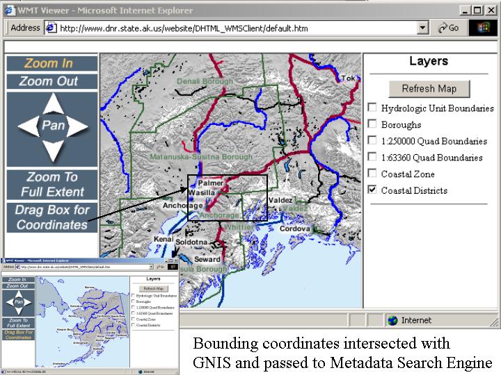
Figure 3.CIIMMS map tool interface.
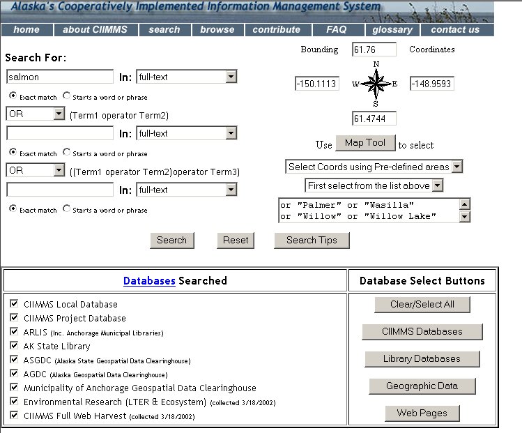
Figure 4.CIIMMS advanced search page.
The map tool provided a map based metadata search function and allows contributors to enter geographic location information about their data and projects in metadata records using a map-based data-entry tool. This tool displays local GIS layers, selected boundary files (HUC, Quad, Borough) and a digital gazetteer to generate place name keywords and bounding rectangle coordinates. These criteria are then passed to the Blue Angel Technology MetaStar Enterprise to facilitate the search and discovery of metadata across a variety of metadata profiles (Dublin Core, FGDC, and NBII). Figure 5 shows a sample metadata record retrived from the Anchorage Municipal Library as a reuslt of the map-based and keyword search.
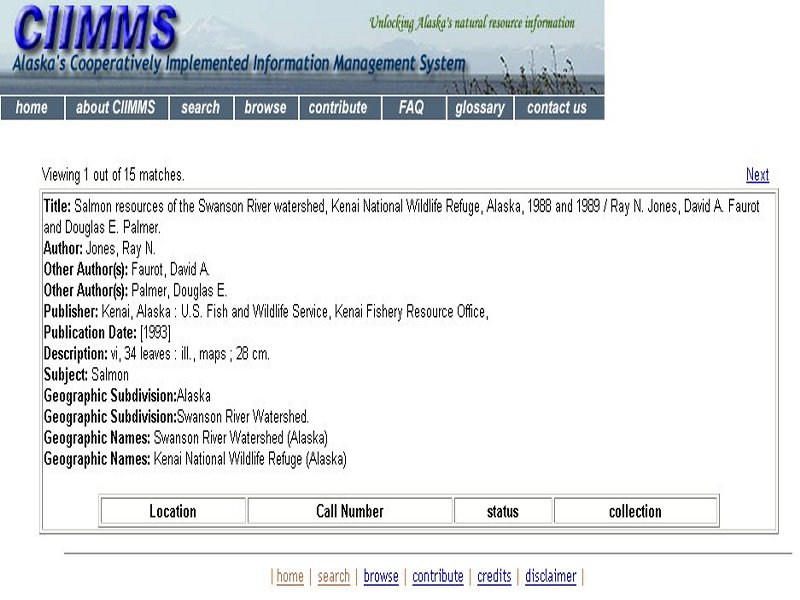
Figure 5.Example metadata record retrieved by the map-based and key-word search.
CIIMMS is a collaborator in the spatial data community and has worked closely with the representatives of the Federal Geographic Data CommitteeÆs National Spatial Data Infrastructure. As such CIIMMS defined the minimum project and data information requirements to be consistent with the FGDC initiated Content Standards for Digital Geospatial Metadata released in 1994, the NBII, and Dublin Core. The FGDC metadata standard is quite complex. CIIMMS has attempted to distill the elements of this standard into an easily understood form for web-based submittal.
This project was funded by the Exxon Valdez Oil Spill (EVOS) Trustee Council. The authors gratefully acknowledge the following individuals for their contributons and guidance during the project: Greg Kellogg, US Environmental Protection Agency, Leslie Patrick, US Geological Survey, and Jeff Hock, Alaska Department of Environmental Conservation.
ADNR, ADEC, SAIC. 2000. "Cook Inlet Information Management and Monitoring System Initial Production Phase Implementation Plan-DRAFT, March, 2000.
SAIC. 1999a. ōCook Inlet Information Management Requirements and Options-Draft Workshop Report.ö Submitted to Alaska Department of Natural Resources and Alaska Department of Environmental Conservation. January, 1999.
SAIC. 1999b. ōCook Inlet Information Management Requirements and Recommendations: Results from the User Needs Workshop.ö Submitted to Alaska Department of Natural Resources and Alaska Department of Environmental Conservation. March, 1999.
Zeiner, Kelly et. al. 2000. ōDevelopment of the Cook Inlet Information Management/Monitoring System (CIIMMS), Watersheds 2000, April 2000.
Zeiner, Kelly et. al. 2000. ōCook Inlet Information Management and Monitoring System Restoration Project 99391, Annual Report,ö May 2000.
Zeiner, Kelly and Russell Kunibe, 2000. Cook Inlet Information Management and Monitoring System (CIIMMS) System Operations and Maintenance Strategy, Draft, August 2000..