Dean Salmons and Daniel Teaf
This paper will explain the use of a Geographic Information System (GIS) within the Florida Department of Transportation’s (FDOT) Turnpike Enterprise Tentative Five Year Work Program. The Tentative Five Year Work Program consists of projects that the Department will undertake to improve Florida’s transportation system during the next five years. The Tentative Five Year Work Program incorporates all levels of project management, from planning and design to post construction services and maintenance of existing roadways. This paper will discuss how a GIS is used on a daily basis to update, analyze, and visualize projects from a statewide perspective as well as solve traffic congestion issues along Turnpike operated roadways. Specific GIS concepts addressed in this paper include the following: dynamic segmentation, database creation, and map generation. In addition this paper will discuss how GIS can be used as a tool for greater public awareness of future impact on residents along Florida’s Turnpike facilities and surrounding communities.
Florida’s Department of Transportation is comprised of seven districts and the Turnpike Enterprise. The Turnpike Enterprise, which was previously considered the eighth district, was created in 1994 due to a growing population and an increasing demand for transportation along Florida’s limited access toll roads. The Turnpike operates more than 400 miles of limited access highways throughout the state and is continually expanding to meet Florida’s growing urban transportation needs.
The Turnpike Mainline extends from north of Miami to northern central Florida where in meets interstate 75. This 265-mile stretch of roadway is the longest of any one facility under the Turnpike jurisdiction. The Mainline, also known as Florida’s “Main Street,” handles nearly one million patrons a day and is divided into three pieces; the southern coin system, ticket system and northern coin system. The total cost for traveling this expanse of roadway is $16.65.
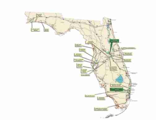
In addition to the Mainline, the Turnpike operates numerous other facilities. Specifically, Turnpike facilities include: the 47 mile Homestead extension (HEFT) which carries patrons to the top of the Florida keys; the 23 mile Sawgrass Expressway in Broward County; the 12 mile Seminole Expressway in Seminole County; the 15 mile Veterans Expressway in Tampa; an 8 mile portion of the Bee Line Expressway in Orlando; the 6 mile Southern Connector Extension of the Central Florida Greeneway in Orlando; the 25 mile Polk Parkway in Lakeland; and the 41 mile Suncoast Parkway on Florida’s West Coast. Currently, the Turnpike Enterprise owns or operates 449 miles of limited access highway, and is continually looking to expand in order to meet Florida’s expected future transportation needs (figure 1). Florida’s Turnpike is a patron-financed system that uses toll revenues and bonds to pay for new construction and continued maintenance.
Figure 1
The Florida Department of Transportation’s Five-Year Work Program is a list of improvements, which the Department will undertake during the next five fiscal years. Each of the Department’s seven districts, as well as the Turnpike Enterprise, is responsible for developing their own Five Year Work Program. Updated annually, these adopted Five Year Work Programs serve as the guideline the Districts will follow to develop a safe, interconnected transportation system for Florida’s citizens and visitors.
In order for a Five Year Work Program to be adopted by the Department, tremendous planning efforts are undertaken and the Districts must coordinate with Metropolitan Planning Organizations (MPO) and local governments. Input from local entities, and citizens via public hearings, is essential in order to fully address all issues and provide a comprehensive Five Year Work Program.The MPOs and local governments are helpful in identifying needs and improvements along Department controlled roadways by encouraging citizen participation and conducting studies. Typical studies include existing traffic congestion and future capacity issues. The MPOs and local governments then produce their annual Transportation Improvement Plan (TIP), which is a list of selected projects in priority order. This list is provided to each District to be incorporated into the Five Year Work Program.
To ensure financial stability of the Work Program, the Department is statutorily required to forecast expected revenues and develop a balanced finance plan. The finance plan must match anticipated revenues to anticipated expenditures. Therefore, the number of eligible projects assessed in the Work Program is contingent upon the Department’s ability to fund them while maintaining existing programs.
The Mission of Florida’s Turnpike is to:
"assist in meeting Florida’s transportations needs
providing a system of user- financed, limited - access
toll highways which meets the needs of
our patrons and protects the interest of our
bondholders.”
The Turnpike Enterprise is a unique entity who’s Tentative Five-Year Work Program is dependent on revenue generated for it’s tolled facilities. A Tentative Five Year Work Program refers to the specific list of prioritized projects prior to adoption. Before the creation of the Turnpike as a separate entity, the Office of Toll Operations operated most toll roads within the state of Florida. The Turnpike is unique in that the money generated from the toll facilities generates revenue, which is then used along with the sale of bonds, to build new limited access highways.The creation of the Turnpike has allowed for focused and concentrated efforts to keep up with Florida’s growing transportation needs.
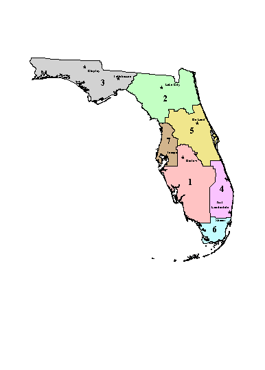
The Turnpike Planning Department is involved in all levels of project development. During the early stages of the planning process, preliminary feasibility and corridor studies are conducted. Information from those studies is taken into consideration and plays an important role in the project selection process. This planning also relies heavily on citizen participation. Many citizens have legitimate concerns on how the Department's projects will effect them. Public hearings are held annually for each District (figure 2) to provide a forum for learning about projects and to deal with issues that citizens may have. The Turnpike contributes to all public hearings for Districts where there is a Turnpike facility.
Figure 2: FDOT District Boundaries
To visualize and understand how a project will impact surrounding areas, high quality, detailed maps are used. These maps create a valuable resource, which allows for planners and citizens to interact and make comprehensive decisions on future projects. All proposed projects can easily be displayed at various scales for public viewing, and this display of spatial information provides for an effective means of communication between all parties involved. In addition, creation of the maps allows for projects to be shown in a real world environment.
New road construction and proposed interchanges can create strong feelings among the local citizens and to avoid frustrations on both sides, a map can represent how proposed projects will benefit entire communities, as well as individual citizens. The public may also voice concern over the amounts of money being spent in their respective community. These maps also display financial information such as construction cost, and show time lines for project completion. In all, the Turnpike Enterprise is heavily involved with public hearings and plays a key role in linking transportation improvement projects with neighboring communities as well as participating with local planning councils to best understand impacts of potential projects.
GIS has become a valuable resource within the Turnpike Enterprise for numerous reasons. The analysis and display of Tentative Five Year Work Program projects allows for a more comprehensive picture of impacts of future and existing projects. The proximity of current projects to future planned projects provides both planners and citizens with previously unforeseen spatial relationships, which provide excellent resources for critical decisions. GIS allows for precise and accurate displays of proposed transportation projects, and can be used for large and small-scale map production. Map generation is the driving force behind the implementation of GIS within the Tentative Five Year Work Program.
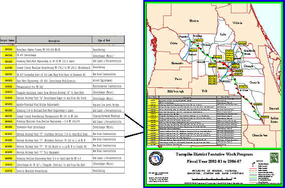
Proposed transportation projects all have one thing in common, location. Location and spatial relationships are what provides the Turnpike with the ability to effectively budget and prioritize Tentative Five Year Work Program projects. This ability is proven during many of the public hearings held throughout the state. Public hearing maps display project locations as well as project identification numbers, project type, and brief project descriptions (figure 3). This information greatly increases the public awareness by providing important and detailed information in a simple and direct manner. Public hearing maps can be displayed for large audiences or scaled down and inserted into handouts or brochures. This versatility allows for the information to be mailed or even handed out door to door in affected neighborhoods and communities.
Prior to implementation of a GIS in the Turnpike Enterprise, maps were not used at public hearings. Simple graphics depicting certain projects were displayed to audiences with limited success. It was difficult to provide the public with the true location of projects and even more difficult to display an individual projects proximity to
Figure 3: Sample Public Hearing Maps
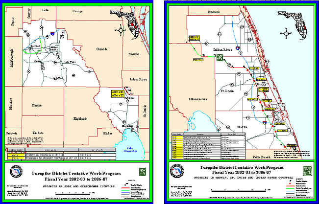
surrounding areas. Graphic displays used prior to the GIS-based maps were of low quality and lacked any real world representation. Today maps produced from the GIS are high quality, professional maps and depict high levels of detail. The GIS allows for large and complex information to be visualized in a consistent and precise manor.
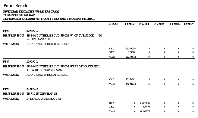
Tentative Five Year Work Program Data is derived from a mainframe database maintained at Central Office. The data is downloaded into large text files and imported into a Microsoft Access database and a report is generated (figure 4). This report is referred to as the Citizen’s Plan and accompanies the map handouts at public hearings. These Citizen’s Plan documents are given to the public on an annual basis, and are a clear and easy to read report showing all projects within the district. The Citizen's Plan is generated on a county-by-county basis, is grouped together for presentations, and handed out at the Districts' public hearings. In addition, the Citizen’s Plan provides much of the financial information as well as construction time frames for the individual projects.
Figure 4: Page from Tentative Five Year Work Program Citizen’s Plan
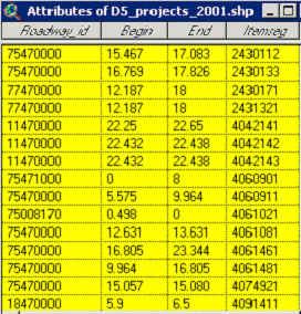
The data downloaded from Central Office contains additional fields, such as begin, end, Roadway_id and Itemseg (figure 5). These four fields provide the information needed for the GIS to create accurate maps. The Begin attribute provides the starting point of the project and the End attribute provides the ending point. The Roadway_id field indicates which facility the project is located on as well as what section of roadway is being referenced and the Itemseg field represents the individual project number. Downloaded into .txt file format, these tables are then added into ArcView and exported to .dbf format. Once in a .dbf file the tables are re-added into ArcView and are then ready to be used in then event theme process.
Figure 5: Attributes of Five Year Work Program Projects Shape file.
At this point, the tables are then joined with additional .dbf files that contain the projects' descriptions and work type attributes. Additional data sometimes is joined depending on the level of detail required in the map. Additional data may include attributes such as descriptions of project locations, capacity improvements, widenings, resurfacings, and maintenance issues.
The next step towards map creation involves downloading files from the Roadway Characteristics Inventory database. This is a statewide database that is maintained in Central Office with the use of ArcInfo software. This database contains characteristics of roadways throughout the state of Florida. Examples include: pavement conditions, road types, interchanges, bridges, and traffic counts. One component of this database is the base map, which consists of an Arc/Info arc coverage and related route systems.
A query of the arcs in the coverage is now necessary to select all limited access roadways that are operated by the Turnpike Enterprise. Once this step is completed, the arcs and route systems are brought into a new coverage and built to ensure all route systems are complete. The new coverage is ready to be added into ArcView for an event theme process.
Now that both components needed to run an event theme have been created, the next step is to map the projects along their corresponding Turnpike facilities. In ArcView the event theme process is run by using the newly created arc coverage as the route theme and the newly created .dbf file containing the fields begin, end and itemseg as the table to be mapped. The results of this event theme will produce a coverage of arcs with various lengths, representing the individual proposed projects. At this point, a shape file of each of the districts proposed projects is created and stored in the GIS library. The completed shapefile of Tentative Five Year Work Program projects contains nearly two dozen fields and upwards of 150 projects.
Final preparation of Tentative Five Year Work Program Maps starts with creating countywide base maps that include Geographic Data Technology (GDT) roadway data along with departmental road layers and the final Work Program shape file. These layers are put together to form the basis of all Tentative Five Year Work Program maps. Mile point locations are used with the Turnpike facility alignments as well as city names and special areas of interests where applicable. Symbolizing the map features can sometimes create confusion for the map-reader so all Public Hearing maps use consistent symbols to represent map features. Next, these county base maps are grouped in accordance with the boundaries of the individual FDOT districts. In addition to these layers, high quality images and graphics are incorporated into the maps. Most Public Hearing maps contain multiple projects and are sometimes difficult to display on one single map (Figure 6). In this case only those projects with more than $500,000 budgeted are displayed.
Figure 6: Sample Public Hearing
Map with multiple projects shown
The next step in preparing the maps for presentation is quality control. Each Public Hearing map goes through a rigorous quality control check with planning staff as well as the Tentative Five Year Work Program scheduling staff. It is critical that all information shown on the maps is accurate and up-to-date. The Tentative Five Year Work Program is updated on a daily basis so insuring quality throughout the maps can be quite challenging. Once final approval from the planning staff is given, the maps are sent to the printer. All maps are originally created at the 8.5 x 11 size layout, and are then printed to the Acrobat distiller and created in .pdf format. The reason behind creating .pdf format maps is to allow for the creation of various sizes of maps. This is especially useful when creating the large E size maps used at the Public Hearing meetings. Traditionally maps are mounted on a 36’’ by 44’’ foam board and finished with a matte laminate for quality display in large meeting rooms.8.5 x 11 size maps are handed out to individual attendees as well. All Public Hearing maps are required to have a FDOT logo and a Turnpike logo on them; this is best achieved by using the stamp tool in Adobe Acrobat 5.0. Previously the logos were brought into the ArcView layout as either a .tiff file or .jpg. It has been determined that the stamp tool can provide for a higher resolution logo and therefore display a cleaner looking logo when shown at different sizes.
Florida’s Turnpike Enterprise plays a vital role in Florida’s transportation needs. To effectively deal with the growing demand of transportation needs, the Turnpike must contend with various private and public concerns regarding transportation issues. Through forming strong ties and having open lines of communication with all those involved, the Turnpike continues to provide effective transportation solutions for Turnpike patrons.
Florida’s Department of Transportation Five Year Work Program and the Turnpike Tentative Five Year Work Program provide a comprehensive list of future transportation projects that require a great deal of planning and coordination. To gain an understanding of how the Turnpike prioritizes projects for future needs, the use of maps has proven to be an efficient means of conveying spatially related information to the public. The Public Hearing maps provide detailed and precise information such as location and scope of future planned projects within the department to the general public as well as local municipalities. The recent implementation of GIS technology in the Tentative Five Year Work Program has created a new way of sharing spatial information within local communities and has stream-lined many of the communication methods. Over the past several years maps produced for the Turnpike’s Tentative Five Year Work Program have taken on a consistent look, which can be recognized during District wide Public Hearings. This has allowed for greater public awareness and created a means to involve local citizens and Turnpike patrons.
Dean Salmons is currently a Senior GIS Analyst with URS Corporation and is working as a consultant for Florida's Turnpike District in Orlando, Florida. Mr. Salmons obtained a B.S. degree in Geography from Florida State University in 1996. For the past several years Mr. Salmons has worked exclusively in the transportation sector and has focused on various ways to use GIS as a communication tool for increased public involvement.
Dean Salmons
Senior GIS Analyst
URS Corporation, Consultant to Florida's Turnpike District
Turnpike Headquarters
Milepost 263, Florida's Turnpike
Bldg 5315, Turkey Lake Service Plaza
Ocoee, Florida 34761
Tel:(407) 532-3999 Ext 3814 Fax:(407) 822-6612
e-mail dean.salmons@dot.state.fl.us
e-mail dean_salmons@urscorp.com
Daniel Teaf is the Program Manager of the Spatial Data Analysis Department of Florida’s Turnpike. He has been working with Turnpike for 6 years and hold a M.S. is Geography from Florida State University.
Daniel Teaf
Program Manager
Turnpike District
Turnpike Headquarters
Milepost 263, Florida's Turnpike
Bldg 5315, Turkey Lake Service Plaza
Ocoee, Florida 34761
Tel: (407) 532-3999 Ext 3807
Fax: (407) 822-6612
e-mail daniel.teaf@dot.state.fl.us
Acknowledgements
The authors would like to recognize all who participate in design, maintenance, and creation of Five Year Work Program database as well as those staff responsible for scheduling of Tentative Five Year Work Program projects.