Abstract:
The City of Edmond is continuing to make progress in implementing its GIS goals
of an enterprise wide GIS, including maintenance management and permitting
systems. In 5 years, the City of Edmond has worked on obtaining an accurate
street address map, and with help from The CEDRA Corporation, has collected a
majority of its infrastructure. The City has also updated parcel data acquired
from Oklahoma County to use as a base for addressing, planning, and zoning
layers.
This paper will present the different data layers that the City of Edmond has collected. These include water, sewer/storm, electric infrastructure, and data collected from aerial photography. Also covered is the on-going implementation of the work order system (Cityworks from Azteca Systems) and permitting system (PERMITS Plus from Accela).
INTRODUCTION AND BACKGROUND:
The City of Edmond, Oklahoma is the northern neighbor to Oklahoma City, Oklahoma. Its population is 70,000 and it services about 23,000 water and 29,000 electric utility accounts.The City of Edmond covers approximately 87 square miles. The City of Edmond political structure includes an elected mayor, four council members and an appointed City Manager. The GIS division is placed under the Information Systems Department in the City.
In 1996, the City of Edmond contracted with PlanGraphics, Inc and Black & Veatch to generate a GIS implementation plan with the goal of an enterprise wide implementation. The resulting report contained an assessment of the GIS needs of the City, a conceptual design, and an implementation plan for data collection and application development. Also included were cost estimates and a schedule.
This paper will document the data collection processes the City of Edmond followed to acquire the information necessary for the enterprise wide GIS. Also discussed are the on-going efforts to implement an integrated maintenance management system using Cityworks, as well as a permitting and workflow tracking system using PERMITS Plus.
Finally, we will look at the City of Edmond’s migration plan from 40+ ArcView 3x licenses, shapefiles, coverages and ArcInfo to ArcGIS, ArcIMS and the Geodatabase.
DATA COLLECTION
The existing map data in the City of Edmond were a digital City Street Map with no coordinate reference and hard copies of ˝ section base maps. Most of the utility construction plans were on 35mm microfilm and few of those were “As-Built”. There was a very low confidence level in any existing data set.
Streets
The first project was the GPS collection of a street centerline map. The City had obtained a copy of the 1990 TIGER data, but we could only achieve a 70% address match rate against our utility account file. Centerline data was collected for every street in the city using a vehicle mounted GPS receiver. At the same time, the beginning and ending address for each block was recorded. The resulting address coverage allowed us to achieve a 99% address match rate. The horizontal accuracy of this data set is 3-10ft.
Digital Ortho Photos, Planimetric and Topographic Data
Prior to any GIS activities, the Engineering Department had a highly accurate GPS monument network developed in the City. Based on this, they had digital ortho photos and topography created by drainage basin for 75% of the City. In 1997, GIS had planimetric data (building footprints, fence lines, vegetation areas, hydrography, paving edges) created from the same aerial photography to use as a base for all of the City’s data layers. In 2001, the City updated the original planimetric data and the black and white aerial photography with color photography. The City also had LIDAR data collected and 2 foot contour topographic data developed for the entire city limits. The horizontal accuracy of the digital photography is +-5 foot, the planimetric data is +- 2.5 ft, and the topographic data follows National Map Accuracy Standards for 2 ft contour data.
Parcels
In 1998 the City of Edmond and the Oklahoma County Assessor’s Office reached a data sharing agreement and Edmond received all of the digitized parcels from the County. The parcel DGN files were converted, transformed and polygons were built. They were then adjusted to the City’s base planimetric and orthophotography. Some address attributes were carried over from Oklahoma County Assessor’s database. The address match rate was initially 65%. An intensive in-house effort was required to raise the match rate to 95%. Accuracy of this data set is from 3 –10ft.
Water & Wastewater Data
Prior to selection of a maintenance management system, the conversion project of the water and wastewater data layers was initiated. The City specified a generic database design that included water and sewer main attributes, service laterals, sewer wyes, manholes, valves, etc.The CEDRA Corporation received all of the City’s microfilm rolls and ˝ section maps. They converted the information from the microfilm to shape files. Due to the lack of confidence in the source data, all visible manholes and water valves were surveyed and the data was adjusted to the correct field locations.
An entire paper can be devoted to the conversion and field collection of these two datasets; however, we will limit this discussion to some of the issues. There was a serious underestimation of the project. It was estimated that the City had approximately 6000 manholes. 8500 were located. The estimate for water valves was 4500, the inventory now consists of over 8000 valves. Most of the manholes are located in the back lot easement. That meant gaining access to backyards, or in other words, locked gates, big dogs, woodpiles and birdbaths. There were buried manholes and asphalt-covered valves. However, the City crews were able to do pro-active maintenance on potential problems found during the survey. Because of the accurate survey and conversion, both the Engineering Department and Utility Line Maintenance have confidence in using the information for their daily tasks. Accuracy specified on the field survey was +- 1 ft.
Electric DataIn late 1997, with deregulation of the electric utilities on the horizon and no digital inventory, the City made the decision to begin the collection of its electric infrastructure. Working closely with the Electric Department, GIS developed a simple point data model. Accepting that there might be some additional data required for the maintenance management system, an in-house GPS project was developed. The City established a local base station for differential collection and a two-person electric crew was deployed using Trimble GPS equipment. As the two-person crew collected locations for all the electric features, they numbered each electric pole, and collected serial numbers on all of the transformers. They also obtained information on capacitor banks, streetlights and other features specified in the data model.
Once the point data was downloaded and corrected, it was turned over to a technician in the Electric Department, who connected the points with line features representing the different phase connections. The crews collected more than 10,000 pole features over the course of approximately 4 years. The GPS units used were mapping grade with sub-meter results. They continue to maintain the data set with the same methodology.
StormThe only source documents for the City’s storm infrastructure were microfilmed construction drawings. We saw two options in converting the storm data. One option was to have an in-house crew use GPS equipment and do a field survey. They would walk each square mile and locate what was visible. The problem is that some storm infrastructure, similar to sanitary sewer infrastructure, is along the back lot easement. Gaining access to backyards is a challenge, even if there is a high probability of manholes located there. The second option was to digitize the storm infrastructure from the microfilmed drawings. We contracted with The CEDRA Corporation to perform the conversion from the microfilmed drawings. Delivery was in a format compatible with the Cityworks maintenance management system.
ZoningThe condition of the City’s Zoning Map was deteriorating. It was a wall map in a planner’s office created with mapping tape that was no longer available. The database design of the zoning map was simple: zone designation, ordinance number of the rezoning case, ordinance date, and a Planned Unit Development designation. Special Use Permits such as churches, schools, wells, and cell towers were going to be a point coverage obtained at a later date.
Because of the nature of the source data, the conversion was an in-house project and we made no attempt to maintain historical data. The Planning Department researched the zoning in each section and obtained the zoning ordinance for each parcel zoned. Using the County parcel data as a base layer and the legal descriptions from the ordinances, the zoning map was recreated using Workstation ARCINFO.
The City acquired additional datasets from various sources. Soil data from the Natural Resources Conservation Service is used for drainage analysis. FEMA Q3 data is used for estimation of flood plane areas. Census data, which we conflated to our more accurate data sets, is used for redistricting as well as population analysis
MAINTENANCE MANAGEMENT SYSTEM, PERMITTING, WORKFLOW TRACKING SYSTEMS AND OTHER APPLICATIONS
Prior to implementing a GIS based maintenance management system, nearly all work order, trouble calls and permits were tracked manually. The advantage to the manual system is that there is no historical data to convert. The challenge is changing work processes so that they can be automated.
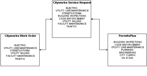
A GIS Technical Committee was formed from staff members of various City departments. There were representatives from the Electric, Utility Line Maintenance (ULM), Street Department, Building Inspections Department and MIS. This committee was responsible for establishing the requirements and selecting the maintenance management system and permitting application, with the focus being enterprise wide. After an extensive evaluation, the GIS Technical Committee selected Esri as the prime contractor with Azteca Systems to provide the GIS integrated maintenance management system and PERMITS Plus as the Permit/Workflow tracking system.
ORACLE was chosen to be the back end database prior to the selection of the applications because of its stability and flexibility. It had just introduced its “ORACLE Workgroup Server”,which made the cost feasible.
Maintenance Management System
All of the modules the City of Edmond required for an enterprise wide maintenance management system were not yet available within Cityworks. Therefore, Esri Professional Services established three separate development tracks based on the needs of the City.
Track 1 included developing the work order management and customer call system requirements and design. A Service Request system problem code hierarchy was established that would handle calls from citizens, and interdepartmental functions such as meter install requests. A biweekly process to download all utility account information from the Utility Billing system into the Service Request was also defined. The water and wastewater maintenance modules were then made available.
Track 2 established the database design, development, and rollout for Streets, Storm and Traffic.
Track 3 addressed the Electric Module.
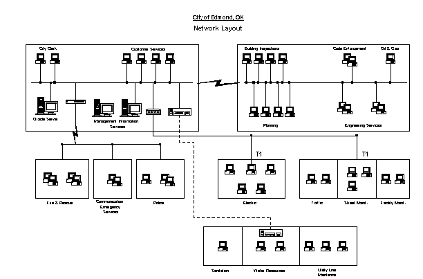
Once the software and datasets mentioned in the previous section were ready for use, it was rolled out in the departments. Because most of the departments using the software were located off site, connected to the network via T1 lines, it was decided that the short-term solution would be to store the shape files locally on each PC. The ORACLE database server would reside in the main computer room on the main campus. This provides for acceptable performance while displaying the different map layers. However, this creates a maintenance issue for the GIS and MIS staff in keeping the different shape files current on each local system.
Defining the different work orders and tasks within each department is a major challenge. New hardcopy work order forms were created for each department. Field crews use these forms to track materials and resources used on each job. These forms then become data entry documents for office personnel. Although automating the work order and service requests streamlined some workflows, additional staffing was necessary in some departments to handle data entry. New reports were created using Seagate Crystal Reports, as well as the ad-hoc reporting capabilities within Cityworks.
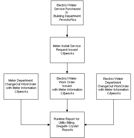
Interdepartmental communication was and continues to be key. Each process has to be defined and integrated across departments and software platforms. For example, when a water meter is purchased, information is recorded in PERMITS Plus by the Building Inspections Department. They also enter a Service Request into Cityworks, which is then processed by the Water Deparment. An interface is being created to eliminate the duplicate data entry.
In 2000, the citywide implementation of the Service Request module was accomplished. The work order system is under constant refinement, as processes are better defined and established.
Permitting, Workflow Tracking Systems
The Building Inspections, Planning, and Engineering Departments were designated to automate their permits and workflows using PERMITS Plus. Code Enforcement, Oil & Gas Inspection Division, Fire Marshals Office and City Clerks office were also identified as potential users of PERMITS Plus.
Implementation of the permitting system began in the Building Inspections Department. The Building Inspections Department is not only responsible for issuing building permits and building inspections, but they also handle contractor registration, the purchasing of meters, and the receipt of planning and engineering permit fees.
The development of the permit activities was based on the receipts issued as well as the different types of inspections. Once the activities and projects were developed in PERMITS Plus, the carbon copy handwritten receipt books were locked away. Temporary data entry operators were hired to back enter all open permits. Daily balancing reports were created using Seagate Crystal Reports and the PERMITS Plus Report Engine.
Code Enforcement is one of the departments that need both Cityworks and PERMITS Plus to function successfully.Cityworks is used to track the initial complaint calls. If follow-up is necessary after the first inspection, a case is created in PERMITS Plus and tracked through compliance.
The Oil & Gas Division had an existing computerized tracking system that was not Y2K compliant. It was found to be more cost effective to manually enter all pertinent information into the PERMITS Plus activity than attempt a data conversion. The data from the old system was then printed out and archived.
There have been PERMITS Plus projects created for and used by the Planning Department. Development has begun for tracking projects in Engineering, including Engineering Inspections and Drainage Engineering. Workflows have been created for Site Plan and Plat Reviews that will be implemented in the near future.
Business and occupational license tracking have been automated using PERMITS Plus in the City Clerks Office, as well as a miscellaneous receipting system. The Electric Department issues invoices via PERMITS Plus that are paid through the City Clerks Office. Again, daily balancing reports were created using Seagate Crystal Reports and PERMITS Plus Report Engine.
Other Applications
The Sanitation Department uses Tower, an ArcView based waste management program from Transcomp Systems. Route layers, parcel data, and geocoded utility account information are maintained by GIS staff. Recently, a new waste transfer station was approved. Gershman, Brickner & Bratton, Inc. (GBB) is using CIVIX FleetRoute in conjunction with our accurate street network and utility account information for route optimization.
Central Communications and Emergency Services also use the data in the MapObjects based GeoNotify system, provided by Dialogic Communications Corporation.
We use ArcView with the aerials, topo, planimetric, utility, and planning layers for real-time presentation in City Council and Planning Commission Meetings. ArcView applications developed in-house are also used in the Fire Departments for grid mapping and in the Police Department for crime analysis.
DATA MAINTENANCE AND MIGRATION ISSUES
Data Updates
The City is changing the requirements for submissions of plats and site plans. They must include surveys opening and closing on City of Edmond monuments. In addition to hardcopy, digital submissions in a standard layer format are required. A new mapping fee has been proposed to fund the maintenance of the affected data sets and provide for field verification. We will continue to update some data sets in-house such as the street centerline and electric data, and plan to use professional services to maintain other data layers. We will evaluate our data maintenance program on a regular basis.
The advantage of migrating to the Geodatabase is clear to the GIS staff. Instead of updating local shape files everywhere in the city, there will be only one location. End users will get the benefit of live updates. However, because of the offsite locations and limitations of the network, they may not get the display performance that they are experiencing with the local shape files.
The City is currently working with Azteca Systems on a migration plan from the 40+ ArcView based work order systems to a combination of ArcIMS and ArcGIS. There is more functionality in an ArcGIS deployment. However, the advantages of an ArcIMS solution are system management and the portability to field systems, which would optimize the work processes further and minimize the additional data entry.
We are looking at a similar solution for PERMIT Plus integration with our GIS data. There is a very loose link between the GIS data and the PERMITS Plus database. We would like to tighten this integration and use the spatial information such as parcel data and zoning more effectively in PERMITS Plus.
CONCLUSION
The City of Edmond’s GIS program began in August 1996 with the goal of becoming an enterprise GIS. This system now provides extensive information about the City’s infrastructure including water, sewer, storm drainage, streets, and the electric distribution system. Planning, zoning, parks and recreation and many other departments’ information are included within the GIS along with data from federal, state and local agencies.
With the use of Azteca Cityworks and Accela’s PERMITS Plus, we are able to access more information about the repairs, maintenance, upgrades and additions to the various areas of infrastructure. This helps the City make more informed decisions on the management of City resources.
The City of Edmond was honored with the Special Achievement Award in GIS from Esri in 1999. In 2002, the South Central Arc Users Group presented the 2002 South Central Arc Users Group Founders Award and praised Edmond for the enterprise-wide GIS that is being implemented.
The success of the GIS system depends on key people in each department. They must have detailed knowledge of the work processes throughout the organization, not just within their department. With the flexibility to replace outdated methodologies and adopt new technologies, improved planning and services can be provided to the citizens of the City.
Sara Cobb
GIS Manager
City of Edmond, Oklahoma USA
sara.cobb@ci.edmond.ok.us
www.edmondok.com
Footnotes:
Azteca, Azteca Systems, Cityworks, MyCityworks.com, azteca.com and @azteca.com are either registered trademarks or trademarks of Azteca Systems, Inc. in the United States and/or other countries.
ARCINFO, ArcGIS, ArcIMS, ArcView are trademarks, registered trademarks, or service marks of Esri in the United States, the European Community, or certain other jurisdictions.
PERMITS Plus is either a registered trademark or trademark of Accela, Inc. in the United States and/or other countries.