Figure 2: Current Annexation Workflow diagram
Elizabeth Young and Brian Besier
City of Fort Worth
The City of Fort Worth currently utilizes a distributed Geographic Information System. Departments are responsible for individual layers that are stored in various locations and formats throughout the City. In an effort to provide access for all GIS users Citywide, the IT Solutions Department will utilize ArcSDE to store, manage and provide access to GIS data for both city employees and citizens. This paper will overview the processes used in creating a more cohesive Enterprise GIS at the City of Fort Worth.
The City of Fort Worth began implementing Geographic Information Systems (GIS) in 1997. Since then, the number of GIS users has expanded to include approximately 20 ArcInfo users and over 100 ArcView users. These users are spread out across the city in 18 departments. Thus, the idea of implementing an enterprise GIS is no small task.
The IT Solutions Department at the City of Fort Worth is tasked with providing user support, assistance with data sharing and coordinating interdepartmental GIS activities as needed. Therefore, it was the responsibility of the IT Solutions Department to lead the migration to an Enterprise GIS. When GIS needs were evaluated for the city, four areas were identified that needed to be addressed to properly implement an Enterprise GIS system. These areas included:
Without examining these issues, the City of Fort Worth would not be able to efficiently and effectively implement an Enterprise GIS.
The City of Fort Worth’s GIS program has continued to grow since its inception in1997. During this time period an abundance of resources have been spent maintaining over 120 single seat ArcView licenses and over 20 single seat ArcInfo licenses. It was determined that the implementation of a centralized license manager would benefit the City both financially and administratively. In June 2002, the City successfully implemented a license manager for concurrent licenses in ArcView, ArcEditor and ArcInfo reducing the total number of ArcGIS licenses from over 120 single use licenses to 65 concurrent use licenses. The maintenance agreement also covered ArcIMS, ArcSDE, all ArcGIS extensions and Developer Support.
In order to successfully implement an Enterprises GIS system, it is important for all GIS users to receive adequate and on-going training. Throughout the City, employees were using ArcInfo Workstation, ArcView 3.2 and ArcGIS 8. To meet the Enterprise GIS goals, all employees were required to migrate to ArcGIS 8. This migration facilitated the ability to store and edit all data layers in a single location using ArcSDE. A GIS training committee was created with volunteers from various departments to identify and arrange the specialized training needed for City employees. The courses being developed by the training committee are:
These courses will use real Fort Worth data and will be designed primarily to train City employees to use GIS as a tool to perform their normal job functions more efficiently.
The third and largest focus area was data sharing. Prior to the ArcSDE implementation, the IT Solutions Department at the City of Fort Worth maintained a file server that all departments could utilize to store data for a fee. This fee-based structure often hindered users from storing data in a centralized location. Users stored their data locally or on a department server causing data sharing to suffer. The lack of data sharing and communication amongst the GIS users emphasized the need to move from a distributed GIS to an Enterprise GIS system. The decision was made in the summer of 2001 to implement ArcSDE to facilitate the City’s data sharing needs. The goal of SDE was to create a centralized geographic data repository containing 100 vector layers and 115 gigabytes of raster imagery. The IT Solutions Department evaluated and tested SDE on both Oracle and Microsoft SQL Server 2000, and selected Microsoft SQL Server 2000 in November 2001 as the relational database management system (RDBMS) for use with ArcSDE. Figure 1 shows a timeline illustrating the implementation process.
| September 2001 | Install ArcSDE 8.1 with Oracle 8.1.7 RDMS / Begin development of Arc 8.1 editing tools |
| October 2001 | Install ArcSDE 8.1 with SQL Server 2000 RDBMS |
| November 2001 | SQL Server 2000 selected as city’s RDBMS |
| December 2001 | Install ArcIMS on test server |
| January 2002 | Install SDE on a more powerful test server and allow limited use by City departments (< 20 users) |
| June 2002 | Install Esri License Manager |
| June 2002 | Move SDE into production environment (100 + Users) - Phase 1, Installed IMS4.0 on Production Server, Finalize geodatabase updating and editing procedures |
| August 2002 | Begin Cadastral Update in SDE – Phase 2 |
Figure 1: ArcSDE Implementation Timeline.
In the months following the decision to use SQL Server, a considerable amount of time was spent on testing and database design. Part of the testing phase included setting up approximately 20 advanced GIS users in the city with ArcSDE access on a test server.
During Phase 1 of the ArcSDE implementation, IT Solutions conducted a City – wide survey of all GIS users to determine all the geographic datasets used by each department. Basic metadata was collected for each layer, including: owning department, description, update frequency, and primary contact. Understanding the amount of data, data types, and update frequency is crucial when scaling a SDE installation and setting tuning parameters. The compiled list of layers also served as a guide and checklist as the geographic datasets were loaded into SDE.
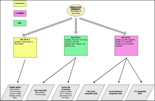
As part of developing the City’s SDE migration strategy, IT Solutions evaluated the current basemap maintenance processes within individual departments and discovered that GIS data is being maintained in multiple file formats in several departments resulting in duplication of effort. To begin the workflow analysis, the City identified three update events: City annexations, subdivision plats filed, and zoning ordinance changes. Each of the update events was diagramed separately to identify the departments involved and the files being edited. Figure 3 shows the current workflow analysis of the annexation event.
Figure 2: Current Annexation Workflow diagram
From the completed workflow diagrams, the City identified 8 critical base layers impacted by the updates that are necessary for a successful implementation of an Enterprise GIS. Table 1 shows the identified layers and the corresponding update event.
| LAYER | UPDATE EVENT |
| Lot/Tract layer | Plat filed |
| Zoning layer | Plat filed / Zoning change |
| Subdivision layer | Plat filed |
| Street Centerline layer | Plat filed |
| City Limit layer | Annexation |
| ETJ layer | Annexation |
| Council District layer | Annexation |
| Fire Hydrant layer | Plat filed |
Table 1: City of Fort Worth base layers
To more efficiently handle the volume of updates, the City has proposed to deviate from the distributed GIS system to shift the maintenance responsibilities of the identified essential base layers to a central group within the IT Solutions department. This will allow the City to streamline the workflow processes based on update events. Figure 4 shows the new annexation workflow.
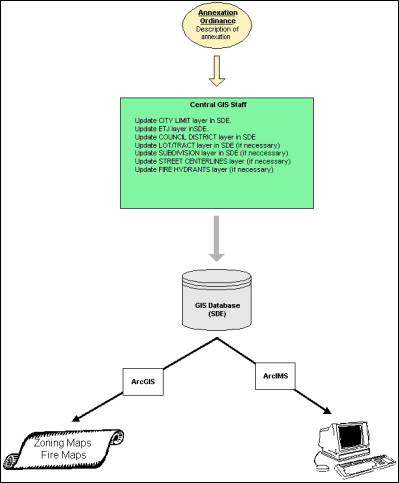
Figure 3: New Annexation Workflow diagram
Implementing the new workflow processes is Phase 2 of the overall SDE Implementation plan. Major tasks include:
Currently, the City is scheduled to begin full basemap editing using ArcGIS and SDE in August 2002.
ArcSDE has proven to be a powerful tool in creating an enterprise level GIS system at the City of Fort Worth. The primary advantage is the accessibility of the data. Users now have a central repository of all spatial and tabular GIS data. Because the GIS data is stored within a RDBMS, it can be readily exported and linked to the City’s Permitting and Computer Aided Dispatch systems. The main disadvantage encountered is the high cost of implementation. Both hardware and software costs are significant, and the time and expense of redeveloping applications using ArcGIS in an organization with highly customized tools developed for workstation ArcInfo or ArcView 3.x can be enormous. Although there is a substantial investment in changing from a distributed to an enterprise GIS, the City of Fort Worth will greatly benefit from the effort. The benefits will be improved data quality, better integration with other City databases, and an increase in access to software and data by GIS users.